ATL: EARL - Remnants - Discussion
Moderator: S2k Moderators
- Hurricaneman
- Category 5

- Posts: 7404
- Age: 45
- Joined: Tue Aug 31, 2004 3:24 pm
- Location: central florida
Re: ATL: INVEST 97L - Models
The models on this are on a disturbing trend towards a stronger storm next week with 97L and will have to be watched especially in the western Gulf and Yucatan
The posts in this forum are NOT official forecast and should not be used as such. They are just the opinion of the poster and may or may not be backed by sound meteorological data. They are NOT endorsed by any professional institution or STORM2K. For official information, please refer to products from the National Hurricane Center and National Weather Service
The posts in this forum are NOT official forecast and should not be used as such. They are just the opinion of the poster and may or may not be backed by sound meteorological data. They are NOT endorsed by any professional institution or STORM2K. For official information, please refer to products from the National Hurricane Center and National Weather Service
0 likes
- tarheelprogrammer
- S2K Supporter

- Posts: 1793
- Joined: Mon Mar 28, 2016 9:25 pm
- Location: Raleigh, NC area (Garner, NC)
Re: ATL: INVEST 97L - Discussion
What stops 97L from just running into the EPAC.
0 likes
My posts are not official forecasts. They are just my opinion and may or may not be backed by sound meteorological data. They are NOT endorsed by any professional institution or storm2k.org. For official information, please refer to the NHC and NWS products.
- Hurricaneman
- Category 5

- Posts: 7404
- Age: 45
- Joined: Tue Aug 31, 2004 3:24 pm
- Location: central florida
Re: ATL: INVEST 97L - Discussion
tarheelprogrammer wrote:What stops 97L from just running into the EPAC.
Its another possibility that can't be discounted but no reliable models are indicating that but looking at it now it seems to have a good MLC but not much at the surface as of now
The posts in this forum are NOT official forecast and should not be used as such. They are just the opinion of the poster and may or may not be backed by sound meteorological data. They are NOT endorsed by any professional institution or STORM2K. For official information, please refer to products from the National Hurricane Center and National Weather Service
0 likes
Re: ATL: INVEST 97L - Discussion
TropicalAnalystwx13 wrote:I'm definitely optimistic about 97L's chances. Its large and broad structure should help it survive the unfavorable conditions it's experiencing now. By days 4 and 5, when it reaches the West Caribbean, the environment is expected to be favorable for development. Low shear, record heat content, above-average ocean temperatures, and enhanced upper-level divergence as a CCKW passes over should favor an amplifying tropical wave at the least, with real potential for the formation of a tropical cyclone. How fast 97L develops and how strong it gets will determine its strength. A stronger storm may gain move more poleward initially thanks to a front off the SE coast, which would put the upper Texas coast in play. A weaker storm that crosses the Yucatan would put Mexico and the southern Texas coastline in play. There are still details to work out, but I think 97L has at least the chance to be the first substantial threat to land in the Atlantic this season.
You have some of my thoughts in about the poleward movement if it strengthens down the road which may be a good possibility.Thye rotation has not left the system even at the the speed it is moving and the sal out there and it's still hanging in.I think some of the GFS ensembles kind of reflect either a weaker high/movement or it's the potential to intensify.
0 likes
- Yellow Evan
- Professional-Met

- Posts: 16231
- Age: 27
- Joined: Fri Jul 15, 2011 12:48 pm
- Location: Henderson, Nevada/Honolulu, HI
- Contact:
Re: ATL: INVEST 97L - Models
Alyono wrote:CMC has development in the EPAC
Euro seems to be doing the same. Probably <10% chance this develops in the Atlantic side at this point.
0 likes
The above post is not official and should not be used as such. It is the opinion of the poster and may or may not be backed by sound meteorological data. It is not endorsed by any professional institution or storm2k.org. For official information, please refer to the NHC and NWS products.
Re: ATL: INVEST 97L - Models
the models that had this developing south of 20N were never given much consideration by myself anyways. This was always going to be a wait until it moves into the Gulf situation. The 0Z models are saying this may not even move far enough north to reach the Gulf
0 likes
Re: ATL: INVEST 97L - Models
Siker wrote:102 hours:
Something strange happened with that run. Storm got very close to the domain boundary, which invalidates the run to a large extent
0 likes
- AtlanticWind
- S2K Supporter

- Posts: 1898
- Age: 67
- Joined: Sun Aug 08, 2004 9:57 pm
- Location: Plantation,Fla
Re: ATL: INVEST 97L - Models
The models seem to be initializing 97L a little farther south than it appears it may Form IMO.
0 likes
Re: ATL: INVEST 97L - Discussion
It certainly has lots of warm water ahead of it:

Does the whole Atlantic seem warmer than usual for this time of year to anyone else, or is it just me?

Does the whole Atlantic seem warmer than usual for this time of year to anyone else, or is it just me?
0 likes
Re: ATL: INVEST 97L - Discussion
Usually as these early Cabo Verde systems get west of -53 they start to pick up a little convection.
Probably a surface temperature thing as Abajon mentioned.
97L is keeping pace with an upper level low currently over Hispaniola rolling west.
That may enhance the usual southerly shear that occurs off South America that systems have to endure transiting the Caribbean.
There is no outflow to vent at this point and apparently the models don't see a favorable environment for development till the western Caribbean.
0 likes
- Medtronic15
- Tropical Depression

- Posts: 53
- Age: 45
- Joined: Fri Jul 01, 2016 5:25 am
- Location: Texas,USA
Re: ATL: INVEST 97L - Models
He we go #Invest97L

0 likes
The posts in this forum are NOT official forecast and should not be used as such. They are just the opinion of the poster and may or may not be backed by sound meteorological data. They are NOT endorsed by any professional institution or STORM2K. For official information, please refer to products from the NHC and NWS.
- Gustywind
- Category 5

- Posts: 12334
- Joined: Mon Sep 03, 2007 7:29 am
- Location: Baie-Mahault, GUADELOUPE
Re: ATL: INVEST 97L - Discussion
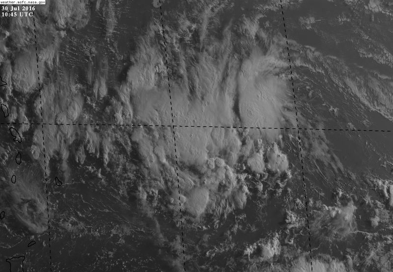
First appareance on SSD...
30/0545 UTC 14.4N 50.6W T1.0/1.0 97L
30/0545 UTC 14.4N 50.6W T1.0/1.0 97L
1 likes
-
ninel conde
Re: ATL: INVEST 97L - Discussion
Nimbus wrote:Usually as these early Cabo Verde systems get west of -53 they start to pick up a little convection.
Probably a surface temperature thing as Abajon mentioned.
97L is keeping pace with an upper level low currently over Hispaniola rolling west.
That may enhance the usual southerly shear that occurs off South America that systems have to endure transiting the Caribbean.
There is no outflow to vent at this point and apparently the models don't see a favorable environment for development till the western Caribbean.
What im seeing is a huge trof developing in the west atl so i think the only place this has a slight chance is deep in the BOC which has been marginally favorable the last few years.
0 likes
- Gustywind
- Category 5

- Posts: 12334
- Joined: Mon Sep 03, 2007 7:29 am
- Location: Baie-Mahault, GUADELOUPE
Re: ATL: INVEST 97L - Discussion
Note that Martinica after Guadeloupe have activated the yellow alert for a risk of strong showers and tstorms.
 http://www.meteofrance.gp/integration/s ... inique.pdf
0 likes
- Gustywind
- Category 5

- Posts: 12334
- Joined: Mon Sep 03, 2007 7:29 am
- Location: Baie-Mahault, GUADELOUPE
Re: ATL: INVEST 97L - Discussion
Tropical Weather Discussion
NWS National Hurricane Center Miami FL
639 AM EDT SAT JUL 30 2016
A well defined tropical wave is moving across the central
Atlantic with axis from 19N50W to 10N50W, moving west at 15 to
20 kt. The tropical wave is evident as a broad and amplified low
to mid level trough between 45W and 55W with abundant deep-layer
moisture in SSMI Total Precipitation Water Vapor Imagery and
satellite derived winds. Recent scatterometer data depicts broad
surface troughing in the same vicinity. The gradient between the
trough and the subtropical ridge to the north is resulting in
fresh to strong trade winds from 13N to 22N between 45W and 55W,
with associated seas to 10 ft. The trade winds convergence is
also supporting scattered moderate convection from 14N to 16N
between 47W and 55W. As this wave moves west during the next
several days, fresh trades accompanied by potentially higher gusts
will move across the waters north of the Greater Antilles and
waters surrounding the Turks and Caicos, southeast Bahamas, and
eastern and central Cuba creating hazardous boating conditions.
0 likes
Who is online
Users browsing this forum: No registered users and 49 guests


