ATL: Ex INVEST 92L - Discussion

Moderator: S2k Moderators

Message
Author
xironman
S2K Supporter
S2K Supporter
Posts: 2522
Joined: Sun Jun 10, 2007 4:53 pm
Location: NoVA

Re: ATL: INVEST 92L - Discussion

#521 Postby xironman » Wed Sep 07, 2016 3:20 pm

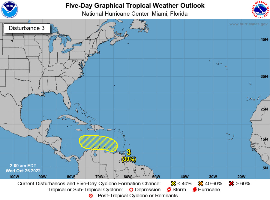
Stormcenter wrote:I never thought model support was a requirement for tropical development. I've seen it happen before without it. Just saying.

xironman wrote:So is this the genesis of the spin off the north coast of Cuba? At the low levels it does not look that bad, but with no models on board I guess it is going nowhere.


Well the models can take a lot into account, like the influx of dry air or lack of instability that might not be apparent from normal observation. Generally when they don't call for development it does not happen, at times it does though. Hence my interest in the spin off Cuba.
0 likes   

User avatar
northjaxpro
S2K Supporter
S2K Supporter
Posts: 8900
Joined: Mon Sep 27, 2010 11:21 am
Location: Jacksonville, FL

Re: ATL: INVEST 92L - Discussion

#522 Postby northjaxpro » Wed Sep 07, 2016 3:46 pm

Image

The ULL is pulling away west- w/sw at a good clip, about to enter into the Central GOM currently and that should allow the system to not encounter any crippling wind shear , plus the anticyclone moving in tandum with ex-92L also will help. Convection still is trying to build along and just off the northeast coast of Cuba.
0 likes   
NEVER, EVER SAY NEVER in the tropics and weather in general, and most importantly, with life itself!!

________________________________________________________________________________________

Fay 2008 Beryl 2012 Debby 2012 Colin 2016 Hermine 2016 Julia 2016 Matthew 2016 Irma 2017 Dorian 2019

User avatar
AJC3
Admin
Admin
Posts: 3999
Age: 61
Joined: Tue Aug 31, 2004 7:04 pm
Location: Ballston Spa, New York
Contact:

Re: ATL: INVEST 92L - Discussion

#523 Postby AJC3 » Wed Sep 07, 2016 4:11 pm

northjaxpro wrote: The ULL is pulling away west- w/sw at a good clip, about to enter into the Central GOM currently and that should allow the system to not encounter any crippling wind shear , plus the anticyclone moving in tandum with ex-92L also will help. Convection still is trying to build along and just off the northeast coast of Cuba.


If the 250 MB progs from the globals are to be believed (and I don't see why they shouldn't be), shear will become less hostile over the central-western Caribbean over the next 2-3 days. However, the area north of Cuba will see the very strong and divergent SW shear currently in place become NW to W, while remaining strong, but not nearly as divergent. This is courtesy of yet another strong mid/upper level trough retrograding SW from offshore the Carolinas through late week.
0 likes   

User avatar
northjaxpro
S2K Supporter
S2K Supporter
Posts: 8900
Joined: Mon Sep 27, 2010 11:21 am
Location: Jacksonville, FL

Re: ATL: INVEST 92L - Discussion

#524 Postby northjaxpro » Wed Sep 07, 2016 4:24 pm

AJC3 wrote:
northjaxpro wrote: The ULL is pulling away west- w/sw at a good clip, about to enter into the Central GOM currently and that should allow the system to not encounter any crippling wind shear , plus the anticyclone moving in tandum with ex-92L also will help. Convection still is trying to build along and just off the northeast coast of Cuba.


If the 250 MB progs from the globals are to be believed (and I don't see why they shouldn't be), shear will become less hostile over the central-western Caribbean over the next 2-3 days. However, the area north of Cuba will see the very strong and divergent SW shear currently in place become NW to W, while remaining strong, but not nearly as divergent. This is courtesy of yet another strong mid/upper level trough retrograding SW from offshore the Carolinas through late week.


I was thinking that mid-ULL trough off the Mid Atantic coast was more of a cutoff Low not moving very much, but it may be moving southwest as you indicated AJC3 We saw a trough axis which helped spawn TD 8 last week off the North Carolina coast.
0 likes   
NEVER, EVER SAY NEVER in the tropics and weather in general, and most importantly, with life itself!!

________________________________________________________________________________________

Fay 2008 Beryl 2012 Debby 2012 Colin 2016 Hermine 2016 Julia 2016 Matthew 2016 Irma 2017 Dorian 2019

User avatar
AJC3
Admin
Admin
Posts: 3999
Age: 61
Joined: Tue Aug 31, 2004 7:04 pm
Location: Ballston Spa, New York
Contact:

Re: ATL: INVEST 92L - Discussion

#525 Postby AJC3 » Wed Sep 07, 2016 5:01 pm

northjaxpro wrote: I was thinking that mid-ULL trough off the Mid Atantic coast was more of a cutoff Low not moving very much, but it may be moving southwest as you indicated AJC3 We saw a trough axis which helped spawn TD 8 last week off the North Carolina coast.


The 250 progs from the ECM/GFS/UKM/CMC are quite similar in showing the ULL retrograding SW underneath the building SE-E CONUS deep layer ridge. By late Friday-early Saturday, it becomes a sharp neutral to slightly negatively tilted trough with its along 77-78W, running from offshore the Carolinas to the central Bahamas. Any remnant piece of the wave that will be sliding WNW north of Cuba will be in really bad place for TC development (or even diurnal convection, for that matter) - the high shear area with dry/confluent/subsident N-NW flow on the upper trough's back side.
0 likes   

User avatar
northjaxpro
S2K Supporter
S2K Supporter
Posts: 8900
Joined: Mon Sep 27, 2010 11:21 am
Location: Jacksonville, FL

Re: ATL: INVEST 92L - Discussion

#526 Postby northjaxpro » Wed Sep 07, 2016 5:39 pm

AJC3 wrote:
northjaxpro wrote: I was thinking that mid-ULL trough off the Mid Atantic coast was more of a cutoff Low not moving very much, but it may be moving southwest as you indicated AJC3 We saw a trough axis which helped spawn TD 8 last week off the North Carolina coast.


The 250 progs from the ECM/GFS/UKM/CMC are quite similar in showing the ULL retrograding SW underneath the building SE-E CONUS deep layer ridge. By late Friday-early Saturday, it becomes a sharp neutral to slightly negatively tilted trough with its along 77-78W, running from offshore the Carolinas to the central Bahamas. Any remnant piece of the wave that will be sliding WNW north of Cuba will be in really bad place for TC development (or even diurnal convection, for that matter) - the high shear area with dry/confluent/subsident N-NW flow on the upper trough's back side.


Yes, that trough likely would be the nail in the coffin as 92L would get sheared relentlessly if indeed it shakes down the way you analyzed, especially if the trough becomes negatively tilted by this weekend.
0 likes   
NEVER, EVER SAY NEVER in the tropics and weather in general, and most importantly, with life itself!!

________________________________________________________________________________________

Fay 2008 Beryl 2012 Debby 2012 Colin 2016 Hermine 2016 Julia 2016 Matthew 2016 Irma 2017 Dorian 2019

User avatar
tpr1967
Tropical Storm
Tropical Storm
Posts: 185
Age: 58
Joined: Sun Jun 15, 2003 8:37 pm
Location: Palmetto,FL

Weak low pressure in Eastern Florida straits (INVEST 92L reactivated)

#527 Postby tpr1967 » Fri Sep 09, 2016 3:25 am

Looking at last visible last night and close up Ir tonight and Radar looks like a weak low pressure area has formed on the North end of tropical wave(ex 92L). What are your thoughts?
1 likes   

User avatar
northjaxpro
S2K Supporter
S2K Supporter
Posts: 8900
Joined: Mon Sep 27, 2010 11:21 am
Location: Jacksonville, FL

Re: Weak low pressure in Eastern Florida straits

#528 Postby northjaxpro » Fri Sep 09, 2016 4:11 am

I thought this was the remnant of ex-92L which has flared up, is that the case?
0 likes   
NEVER, EVER SAY NEVER in the tropics and weather in general, and most importantly, with life itself!!

________________________________________________________________________________________

Fay 2008 Beryl 2012 Debby 2012 Colin 2016 Hermine 2016 Julia 2016 Matthew 2016 Irma 2017 Dorian 2019

Dave C
S2K Supporter
S2K Supporter
Posts: 868
Joined: Thu Sep 04, 2003 4:36 pm
Location: Middleboro, Mass.(midway between Cape Cod and Boston)

Re: Weak low pressure in Eastern Florida straits

#529 Postby Dave C » Fri Sep 09, 2016 5:15 am

Water vapor shows some bad conditions pressing down from the north. Maybe better chance if the gulf moistens up when it tracks into that area.
0 likes   

User avatar
tpr1967
Tropical Storm
Tropical Storm
Posts: 185
Age: 58
Joined: Sun Jun 15, 2003 8:37 pm
Location: Palmetto,FL

Re: Weak low pressure in Eastern Florida straits

#530 Postby tpr1967 » Fri Sep 09, 2016 5:42 am

northjaxpro wrote:I thought this was the remnant of ex-92L which has flared up, is that the case?


Yes this is the northern end of it.
0 likes   

User avatar
tailgater
S2K Supporter
S2K Supporter
Posts: 3339
Joined: Sun Jul 11, 2004 9:13 pm
Location: St. Amant La.

Re: Weak low pressure in Eastern Florida straits

#531 Postby tailgater » Fri Sep 09, 2016 6:05 am

Decent low level structure this morning on this ex-92 wave but big time shear right now and conditions don't get much better in the near future from what I see. Nam carries a weak low along the northern coast of Cuba.
0 likes   
The following post is NOT an official forecast and should not be used as such. It is just the opinion of the poster and may or may not be backed by sound meteorological data. It is NOT endorsed by any professional institution including storm2k.org For Official Information please refer to the NHC and NWS products.

User avatar
cycloneye
Admin
Admin
Posts: 145255
Age: 68
Joined: Thu Oct 10, 2002 10:54 am
Location: San Juan, Puerto Rico

Re: Weak low pressure in Eastern Florida straits

#532 Postby cycloneye » Fri Sep 09, 2016 6:56 am

A small area of disturbed weather associated with a weak low
has formed between Cuba and the western Bahamas. This activity is
expected to spread westward across southern Florida and the Florida
Keys later today and Saturday. Upper-level winds are not favorable
for additional development.
* Formation chance through 48 hours...low...10 percent
* Formation chance through 5 days...low...10 percent
0 likes   
Visit the Caribbean-Central America Weather Thread where you can find at first post web cams,radars
and observations from Caribbean basin members Click Here

User avatar
StormTracker
S2K Supporter
S2K Supporter
Posts: 2903
Age: 59
Joined: Thu Jun 29, 2006 6:06 am
Location: Quail Heights(Redlands), FL.

Re: Weak low pressure in Eastern Florida straits

#533 Postby StormTracker » Fri Sep 09, 2016 7:03 am

cycloneye wrote:
A small area of disturbed weather associated with a weak low
has formed between Cuba and the western Bahamas. This activity is
expected to spread westward across southern Florida and the Florida
Keys later today and Saturday. Upper-level winds are not favorable
for additional development.
* Formation chance through 48 hours...low...10 percent
* Formation chance through 5 days...low...10 percent

Image
0 likes   
Something's wrong when you regret, things that haven't happened yet!

User avatar
northjaxpro
S2K Supporter
S2K Supporter
Posts: 8900
Joined: Mon Sep 27, 2010 11:21 am
Location: Jacksonville, FL

Re: Weak low pressure in Eastern Florida straits

#534 Postby northjaxpro » Fri Sep 09, 2016 7:14 am

Trough which dropped down south down the Mid Atlantic to about the Central Bahamas has caused unfavorable shear environment for now. However, if it survives the next few days, it may find a bit better conditions once it gets into the SE Gulf of Mexico. We will monitor it.
0 likes   
NEVER, EVER SAY NEVER in the tropics and weather in general, and most importantly, with life itself!!

________________________________________________________________________________________

Fay 2008 Beryl 2012 Debby 2012 Colin 2016 Hermine 2016 Julia 2016 Matthew 2016 Irma 2017 Dorian 2019

User avatar
srainhoutx
S2K Supporter
S2K Supporter
Posts: 6919
Age: 67
Joined: Sun Jan 14, 2007 11:34 am
Location: Haywood County, NC
Contact:

Re: Weak low pressure in Eastern Florida straits

#535 Postby srainhoutx » Fri Sep 09, 2016 7:42 am

The ECMWF suggests the wave axis will move West across the Gulf and near Texas later next week. Probably nothing more that a rain maker along the Gulf Coast, but anytime there is an Easterly Wave moving across the Gulf in mid September, it is worth monitoring.
1 likes   
Carla/Alicia/Jerry(In The Eye)/Michelle/Charley/Ivan/Dennis/Katrina/Rita/Wilma/Ike/Harvey

Member: National Weather Association
Wx Infinity Forums
http://wxinfinity.com/index.php

Facebook.com/WeatherInfinity
Twitter @WeatherInfinity

Frank P
S2K Supporter
S2K Supporter
Posts: 2772
Joined: Fri Aug 29, 2003 10:52 am
Location: Biloxi Beach, Ms
Contact:

Re: Weak low pressure in Eastern Florida straits

#536 Postby Frank P » Fri Sep 09, 2016 7:50 am

Looking at the few loops available on the vis sat it does appear ATM to have a decent LLC, all the convection that is trying to build is just southeast of the center of rotation... not sure if it will survive the shear, probably not, nor how long this LLC can exist, but it is an interesting little feature to watch... appears to be heading off to the WNW or just due north of west... somewhere in-between perhaps.. additionally, rotation showing up on the long range radar loop out of Miami..
0 likes   

User avatar
ronjon
Category 5
Category 5
Posts: 4822
Joined: Fri Aug 19, 2005 5:17 pm
Location: Hernando Beach, FL

Re: Weak low pressure in Eastern Florida straits

#537 Postby ronjon » Fri Sep 09, 2016 7:59 am

Only model support I could find is the NAM - forms a weak 1011 mb low in the SE GOM. Yes I know its the NAM.

http://www.tropicaltidbits.com/analysis/models/?model=namconus&region=us&pkg=ref_frzn&runtime=2016090906&fh=84&xpos=0&ypos=221&xpos=0&ypos=221
1 likes   

stormlover2013

Re: Weak low pressure in Eastern Florida straits

#538 Postby stormlover2013 » Fri Sep 09, 2016 8:01 am

the nam babyyy lol man that model
0 likes   

User avatar
tpr1967
Tropical Storm
Tropical Storm
Posts: 185
Age: 58
Joined: Sun Jun 15, 2003 8:37 pm
Location: Palmetto,FL

Re: Weak low pressure in Eastern Florida straits

#539 Postby tpr1967 » Fri Sep 09, 2016 8:06 am

On latest visible seems that maybe llc is trying to get closer to the convection. But still upper level winds are strong out of nw.
0 likes   

User avatar
lrak
S2K Supporter
S2K Supporter
Posts: 1770
Age: 58
Joined: Thu Jun 21, 2007 2:48 pm
Location: Corpus Christi, TX

Re: Weak low pressure in Eastern Florida straits

#540 Postby lrak » Fri Sep 09, 2016 8:37 am

Is this little system 92L leftovers?
0 likes   
AKA karl

Also
Personal Forecast Disclaimer:
My posts on this forum are NOT official forecast and should not be used as such. My posts are my basic observations and are definitely not backed by any "well some" meteorological knowledge. For official information, please refer to the NHC and NWS products.


Return to “2016”

Who is online

Users browsing this forum: No registered users and 5 guests