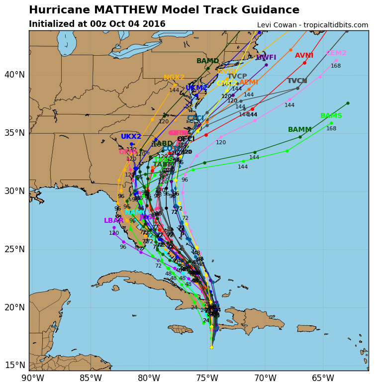
ATL: MATTHEW - Models

Moderator: S2k Moderators

Message
Author
User avatar
SEASON_CANCELED
Category 3
Category 3
Posts: 887
Joined: Mon Jul 06, 2009 5:17 am
Location: 8 Bit Charlie Sheen

Re: ATL: MATTHEW - Models

#5521 Postby SEASON_CANCELED » Mon Oct 03, 2016 7:42 pm

HurricaneWarning92 wrote:
Evil Jeremy wrote:
SEASON_CANCELED wrote:Don't kid yourself the models are going to keep trending west ...somebody will get a direct hit


We don't know either of those for a fact. Is it possible the models will keep going west? Sure. Probable? Perhaps. But we don't know for certain. Same goes for a direct hit. Even if it's probable, we can't talk like we have already seen the future.


This. We don't know that for sure. Models could swing back to the east for all we know.


It's possible but the 5 day window is closing the models accuracy is getting better and better with each run. The chances are against that. I think it shifts 75 miles west or yet and settles back around Okeechobee. My opinion based on the trend


The posts in this forum are NOT official forecasts and should not be used as such. They are just the opinion of the poster and may or may not be backed by sound meteorological data. They are NOT endorsed by any professional institution or STORM2K. For official information, please refer to products from the NHC and NWS.
0 likes   
i am a big stupid ugly moron with an ugly face and a big butt and my butt stinks and i like to kiss my own butt

stormreader

Re: ATL: MATTHEW - Models

#5522 Postby stormreader » Mon Oct 03, 2016 7:45 pm

gatorcane wrote:18Z NAVGEM, landfall West Palm Beach 78 hours.

https://s13.postimg.org/5r7eef3uf/nvg10 ... oplant.gif

Just three days away from possible terrific hurricane landfall, according to that model. Fl should really be transitioning from the speculation stage to the preparation stage. Talk about models shifting back east is almost inappropriate now. The storm is getting too close (time) and it looks be very bad. As we close in on the 72 hr window, even our under performing and erratic models will be coming together for a consensus track. That track is coming into focus now.
1 likes   

User avatar
gatorcane
S2K Supporter
S2K Supporter
Posts: 23692
Age: 47
Joined: Sun Mar 13, 2005 3:54 pm
Location: Boca Raton, FL

Re: ATL: MATTHEW - Models

#5523 Postby gatorcane » Mon Oct 03, 2016 7:46 pm

Blown Away wrote:http://i65.tinypic.com/anby43.jpg
00z Guidance...


Yep looks like a slight shift west...
0 likes   

Ken711
Category 5
Category 5
Posts: 1074
Joined: Tue Aug 28, 2012 12:48 pm

Re: ATL: MATTHEW - Models

#5524 Postby Ken711 » Mon Oct 03, 2016 7:48 pm

stormreader wrote:
gatorcane wrote:18Z NAVGEM, landfall West Palm Beach 78 hours.

https://s13.postimg.org/5r7eef3uf/nvg10 ... oplant.gif

Just three days away from possible terrific hurricane landfall, according to that model. Fl should really be transitioning from the speculation stage to the preparation stage. Talk about models shifting back east is almost inappropriate now. The storm is getting too close (time) and it looks be very bad. As we close in on the 72 hr window, even our under performing and erratic models will be coming together for a consensus track. That track is coming into focus now.


Why?
Last edited by Ntxw on Mon Oct 03, 2016 7:50 pm, edited 1 time in total.
Reason: Removed img tags
1 likes   

Digital-TC-Chaser

Re: ATL: MATTHEW - Models

#5525 Postby Digital-TC-Chaser » Mon Oct 03, 2016 7:51 pm

18z GDFL
Image
0 likes   

User avatar
NDG
S2K Supporter
S2K Supporter
Posts: 15448
Joined: Sun Jul 09, 2006 10:14 pm
Location: Orlando, FL

Re: ATL: MATTHEW - Models

#5526 Postby NDG » Mon Oct 03, 2016 7:54 pm

I was driving to Tampa this evening while the 18z GFS was coming in, I almost lost control of the car. That run is almost as bad as if was to make landfall instead of running parallel to the FL east coast as it shows hurricane force winds to reach the coast for a large area of immediate coastal communities
1 likes   

stormreader

Re: ATL: MATTHEW - Models

#5527 Postby stormreader » Mon Oct 03, 2016 7:56 pm

Ken711 wrote:
stormreader wrote:
gatorcane wrote:18Z NAVGEM, landfall West Palm Beach 78 hours.

https://s13.postimg.org/5r7eef3uf/nvg10 ... oplant.gif

Just three days away from possible terrific hurricane landfall, according to that model. Fl should really be transitioning from the speculation stage to the preparation stage. Talk about models shifting back east is almost inappropriate now. The storm is getting too close (time) and it looks be very bad. As we close in on the 72 hr window, even our under performing and erratic models will be coming together for a consensus track. That track is coming into focus now.


Why?

Because people in Fl don't have time to engage in thinking that is becoming a form of denial. How long should one continue waiting for a model shift east? Wait until a possible cat 4 storm is on your doorstep. We're within a time frame now when model accuracy greatly increases! This is not 2 or 3 days ago. The storm will either be just offshore of Fl, or more likely as models are trending, make a landfall somewhere along the Fl coast. People need to prepare. If the storm passes well to the east without major effects it will almost be miracle. But people right now should begin to prepare for the worst.
1 likes   

User avatar
NDG
S2K Supporter
S2K Supporter
Posts: 15448
Joined: Sun Jul 09, 2006 10:14 pm
Location: Orlando, FL

Re: ATL: MATTHEW - Models

#5528 Postby NDG » Mon Oct 03, 2016 7:57 pm

Ken711 wrote:
stormreader wrote:
gatorcane wrote:18Z NAVGEM, landfall West Palm Beach 78 hours.

https://s13.postimg.org/5r7eef3uf/nvg10 ... oplant.gif

Just three days away from possible terrific hurricane landfall, according to that model. Fl should really be transitioning from the speculation stage to the preparation stage. Talk about models shifting back east is almost inappropriate now. The storm is getting too close (time) and it looks be very bad. As we close in on the 72 hr window, even our under performing and erratic models will be coming together for a consensus track. That track is coming into focus now.


Why?


I am sure this will make the NHC put some parts of SE FL coastal areas under a watch tonight for Residents start making preparations.

Image
1 likes   

Ken711
Category 5
Category 5
Posts: 1074
Joined: Tue Aug 28, 2012 12:48 pm

Re: ATL: MATTHEW - Models

#5529 Postby Ken711 » Mon Oct 03, 2016 8:05 pm

NDG wrote:
Ken711 wrote:
stormreader wrote:Just three days away from possible terrific hurricane landfall, according to that model. Fl should really be transitioning from the speculation stage to the preparation stage. Talk about models shifting back east is almost inappropriate now. The storm is getting too close (time) and it looks be very bad. As we close in on the 72 hr window, even our under performing and erratic models will be coming together for a consensus track. That track is coming into focus now.


Why?


I am sure this will make the NHC put some parts of SE FL coastal areas under a watch tonight for Residents start making preparations.

Image


I'm sure the NHC will make announcements soon perhaps at the 11:00 PM advisory.
1 likes   

User avatar
meriland23
Category 5
Category 5
Posts: 1239
Age: 37
Joined: Mon Aug 29, 2011 9:29 pm

Re: ATL: MATTHEW - Models

#5530 Postby meriland23 » Mon Oct 03, 2016 8:11 pm

I can't believe the massive changes today. I understand this hurricane has been a rollercoaster back and forth but, today was probably the largest, most significant shift I've seen thus far for Matthew, in terms of.track...AND intensity
1 likes   
The posts in this forum are NOT official forecast and should not be used as such. They are just the opinion of the poster and may or may not be backed by sound meteorological data. They are NOT endorsed by any professional institution or storm2k.org. For official information, please refer to the NHC and NWS products.

stormreader

Re: ATL: MATTHEW - Models

#5531 Postby stormreader » Mon Oct 03, 2016 8:13 pm

Ken711 wrote:
NDG wrote:
Ken711 wrote:
Why?


I am sure this will make the NHC put some parts of SE FL coastal areas under a watch tonight for Residents start making preparations.

Image


I'm sure the NHC will make announcements soon perhaps at the 11:00 PM advisory.

They almost certainly will, Ken. And it's all good. This board serves a purpose for those who have a genuine interest in tropical cyclones. They are incredible and fascinating creatures. But infrequently the board also has to come acknowledge for people in the United States the oncoming danger posed by these storms. It's time now to fulfill that function. This storm has all the potential to be one of Fl's very worst.
1 likes   

User avatar
Nimbus
Category 5
Category 5
Posts: 5310
Joined: Mon Jul 19, 2004 10:54 am

Re: ATL: MATTHEW - Models

#5532 Postby Nimbus » Mon Oct 03, 2016 8:17 pm

Some of the 18Z models have the core winds right on the beaches, no mistaking its a serious situation for the storm planners. How are the official wind probabilities doing for the Florida east coast?
For example over 50% chance for the third tier wind speeds above 64 knots might be the trigger for a level evacuation.
0 likes   

User avatar
JaxGator
Category 2
Category 2
Posts: 780
Joined: Sun Jun 12, 2016 3:33 pm
Location: Jacksonville Florida

Re: ATL: MATTHEW - Models

#5533 Postby JaxGator » Mon Oct 03, 2016 8:21 pm

NDG wrote:
Ken711 wrote:
stormreader wrote:Just three days away from possible terrific hurricane landfall, according to that model. Fl should really be transitioning from the speculation stage to the preparation stage. Talk about models shifting back east is almost inappropriate now. The storm is getting too close (time) and it looks be very bad. As we close in on the 72 hr window, even our under performing and erratic models will be coming together for a consensus track. That track is coming into focus now.


Why?


I am sure this will make the NHC put some parts of SE FL coastal areas under a watch tonight for Residents start making preparations.

Image


Look like another west shift doesn't it?
0 likes   
The posts or stuff said are NOT an official forecast. Please look to the NHC and NWS for official forecasts and products.

Floyd-1999, Frances-2004, Jeanne-2004, Fay-2008, Beryl-2012, Debby-2012, Colin-2016, Hermine-2016, Julia-2016, Matthew-2016, Irma-2017, Elsa-2021, Idalia-2023, Debby-2024, Helene-2024.


Go Gators! Go Jags!

User avatar
gatorcane
S2K Supporter
S2K Supporter
Posts: 23692
Age: 47
Joined: Sun Mar 13, 2005 3:54 pm
Location: Boca Raton, FL

Re: ATL: MATTHEW - Models

#5534 Postby gatorcane » Mon Oct 03, 2016 8:23 pm

SFWMD spaghetti, red line is NHC track:

Image
Last edited by gatorcane on Mon Oct 03, 2016 8:23 pm, edited 1 time in total.
0 likes   

Michele B
S2K Supporter
S2K Supporter
Posts: 1114
Joined: Thu Aug 25, 2016 8:08 am
Location: SWFL

Re: ATL: MATTHEW - Models

#5535 Postby Michele B » Mon Oct 03, 2016 8:23 pm

Ken711 wrote:
stormreader wrote:
gatorcane wrote:18Z NAVGEM, landfall West Palm Beach 78 hours.

https://s13.postimg.org/5r7eef3uf/nvg10 ... oplant.gif

Just three days away from possible terrific hurricane landfall, according to that model. Fl should really be transitioning from the speculation stage to the preparation stage. Talk about models shifting back east is almost inappropriate now. The storm is getting too close (time) and it looks be very bad. As we close in on the 72 hr window, even our under performing and erratic models will be coming together for a consensus track. That track is coming into focus now.


Why?


WHY should we be preparing rather than speculating now?

If that is the question, the answer is: there are approximately 8 million Floridians that may need to prepare for a storm the likes of which most of them have never experienced before.
0 likes   
Cleo - 1964, Betsy - 1965, David - 1979, Andrew - 1992, Charlie (Francis, Ivan, Jeanne) - 2004, Irma - 2017, Ian - 2022

Michele B
S2K Supporter
S2K Supporter
Posts: 1114
Joined: Thu Aug 25, 2016 8:08 am
Location: SWFL

Re: ATL: MATTHEW - Models

#5536 Postby Michele B » Mon Oct 03, 2016 8:24 pm

JaxGator wrote:
NDG wrote:
Ken711 wrote:
Why?


I am sure this will make the NHC put some parts of SE FL coastal areas under a watch tonight for Residents start making preparations.

Image


Look like another west shift doesn't it?


More models going west, yes, I'd say.
0 likes   
Cleo - 1964, Betsy - 1965, David - 1979, Andrew - 1992, Charlie (Francis, Ivan, Jeanne) - 2004, Irma - 2017, Ian - 2022

GTStorm
Tropical Storm
Tropical Storm
Posts: 225
Joined: Sat Sep 04, 2004 8:44 pm
Location: Savannah

Re: ATL: MATTHEW - Models

#5537 Postby GTStorm » Mon Oct 03, 2016 8:29 pm

gatorcane wrote:SFWMD spaghetti, red line is NHC track:

Image


Dang. That's not good for coastal Georgia, or anyone along the East coast really. Most of the time these things go away from here. Let's hope there's something the models aren't picking up yet...
0 likes   

invest man
Tropical Storm
Tropical Storm
Posts: 206
Joined: Sun Aug 17, 2008 8:12 pm

Re: ATL: MATTHEW - Models

#5538 Postby invest man » Mon Oct 03, 2016 8:35 pm

According to latest 00z models, looks close to Florida, but looks to be zeroing in on a landfall between Surf City, NC & Ocracoke NC. Agree or disagree. Been watching models for a while and it looks like they have been anywhere from Emerald Isle NC to 100 miles off Hatteras OBX. The west shift now puts most of ENC in the crosshairs! If so any idea of what models are calling for strength wise?
0 likes   

User avatar
Weatherguy173
Tropical Storm
Tropical Storm
Posts: 148
Age: 31
Joined: Wed Aug 01, 2012 10:55 pm
Location: Short Hills NJ

Re: ATL: MATTHEW - Models

#5539 Postby Weatherguy173 » Mon Oct 03, 2016 8:37 pm

The way the models have been shifting over the last 24 hours has been astounding. West, east, west, more west. Makes you wonder, where will they shift in the future? Towards the mid-atlantic? Further east? Toward NY/NJ? With this storm there is no answer. The East Coast cannot afford another hurricane.
0 likes   
Nothing I say is intended to be a forecast; it's only food for thought and friendly advice!

boulderrr
Tropical Depression
Tropical Depression
Posts: 55
Joined: Mon Aug 22, 2016 11:30 am
Location: Nederland, Colorado - 8,500'

Re: ATL: MATTHEW - Models

#5540 Postby boulderrr » Mon Oct 03, 2016 8:41 pm

JaxGator wrote:
Look like another west shift doesn't it?


Looks like a western shift in the short to medium term and an eastward shift in the long term. Beyond North Carolina, most of the models have shifted eastward suggesting a track further from the Northeast. Look how far east the consensus line shifted beyond 120 hours between 18Z and 00Z. I'm assuming this is due to Matthew's slower expected motion and the eastward progression of the storm that will be bringing me snow here in Colorado Wednesday night into Thursday.
2 likes   


Return to “2016”

Who is online

Users browsing this forum: No registered users and 3 guests