ATL: MATTHEW - Post-Tropical - Discussion

Moderator: S2k Moderators

Message
Author
stormreader

Re: ATL: MATTHEW - Hurricane - Discussion

#5801 Postby stormreader » Tue Oct 04, 2016 4:15 pm

stephen23 wrote:Seems when speeding up radar loop that there has been some good northwest jogs every now and then over past few hours. Is it already starting to make it's turn a little bit? That would verify what some were questioning with the Euro

I think you're going to find a pretty hard left turn. At least enough so that as it heads toward Fl it will consistently be a little south of the most recent Euro run. But I do expect that model to catch up to this sometime tomorrow and shift south and west.
1 likes   

xironman
S2K Supporter
S2K Supporter
Posts: 2522
Joined: Sun Jun 10, 2007 4:53 pm
Location: NoVA

Re: ATL: MATTHEW - Hurricane - Discussion

#5802 Postby xironman » Tue Oct 04, 2016 4:16 pm

Aric Dunn wrote:
xironman wrote:w
Aric Dunn wrote:
no multiple dropsondes measured 127kts to 129kts after it crossed hati.

Well, #1 is that I was backing it up that 125 knots was ok because who knows if the recon flight hit the highest wind spots. #2. You don't use dropsondes for sustained wind speeds since they only capture momentary winds, AFM corrected me on that one.


They have been using dropsonde data for advisories this entire system as well as many others.

the upgrade to Cat 5 was due to multiple dropsondes.


Sure, point me to the discussion where they use dropsonde data for sustained winds.
0 likes   

Panfan1995

Re: ATL: MATTHEW - Hurricane - Discussion

#5803 Postby Panfan1995 » Tue Oct 04, 2016 4:17 pm

Can someone tell me why the models shifted east and now are crazy? We have a blocking ridge and growing snd we have a stalled trough. What made the models change so dramatically and then the latest euro go crazy to the point of a double hit on FL and then to GOM? This makes no sense
0 likes   

ozonepete
Professional-Met
Professional-Met
Posts: 4743
Joined: Mon Sep 07, 2009 3:23 pm
Location: From Ozone Park, NYC / Now in Brooklyn, NY

Re: ATL: MATTHEW - Hurricane - Discussion

#5804 Postby ozonepete » Tue Oct 04, 2016 4:18 pm

Happy Pelican wrote:I know all eyes are on Florida but do you think the threat to NY/Jersey Shore is somewhat off the table?


No, sorry. You'll have to wait until at least Thursday to know.
0 likes   

stephen23
Category 1
Category 1
Posts: 341
Joined: Sat Aug 04, 2012 10:57 pm
Location: North Fort Worth

Re: ATL: MATTHEW - Hurricane - Discussion

#5805 Postby stephen23 » Tue Oct 04, 2016 4:19 pm

stormreader wrote:
stephen23 wrote:Seems when speeding up radar loop that there has been some good northwest jogs every now and then over past few hours. Is it already starting to make it's turn a little bit? That would verify what some were questioning with the Euro

I think you're going to find a pretty hard left turn. At least enough so that as it heads toward Fl it will consistently be a little south of the most recent Euro run. But I do expect that model to catch up to this sometime tomorrow and shift south and west.


Not sure what your trying to say. It was the latest Euro who came out south and west of other major model runs in the first place. It was the south and west location in the Euro run who some were questioning through first 24 hours of the latest run.
1 likes   
Personal Forecast Disclaimer:
The posts in this forum are NOT official forecast and should not be used as such. They are just the opinion of the poster and may or may not be backed by sound meteorological data. They are NOT endorsed by any professional institution or storm2k.org. For official information, please refer to the NHC and NWS products.

Aric Dunn
Category 5
Category 5
Posts: 21238
Age: 42
Joined: Sun Sep 19, 2004 9:58 pm
Location: Ready for the Chase.
Contact:

Re: ATL: MATTHEW - Hurricane - Discussion

#5806 Postby Aric Dunn » Tue Oct 04, 2016 4:19 pm

xironman wrote:
Aric Dunn wrote:
xironman wrote:w
Well, #1 is that I was backing it up that 125 knots was ok because who knows if the recon flight hit the highest wind spots. #2. You don't use dropsondes for sustained wind speeds since they only capture momentary winds, AFM corrected me on that one.


They have been using dropsonde data for advisories this entire system as well as many others.

the upgrade to Cat 5 was due to multiple dropsondes.


Sure, point me to the discussion where they use dropsonde data for sustained winds.


looking for the cat five one.. but here when it was still intensifying

"Matthew has continued to rapidly strengthen at a remarkable rate
today. A NOAA Hurricane Hunter aircraft recently reported a peak
SFMR wind of 116 kt and flight-level winds of 121 kt. A recent
dropsonde from the aircraft indicated that surface winds are around
120 kt. Based on all of these data, the initial intensity is set to
120 kt,
an increase of 55 kt in the last 24 hours. The latest
pressure estimate from the aircraft is 949 mb, a drop of 44 mb since
this time yesterday."
2 likes   
Note: If I make a post that is brief. Please refer back to previous posts for the analysis or reasoning. I do not re-write/qoute what my initial post said each time.
If there is nothing before... then just ask :)

Space & Atmospheric Physicist, Embry-Riddle Aeronautical University,
I believe the sky is falling...

Hamanard
Tropical Low
Tropical Low
Posts: 22
Joined: Tue Sep 27, 2016 6:14 pm
Location: Skidaway Island, GA

Re: ATL: MATTHEW - Hurricane - Discussion

#5807 Postby Hamanard » Tue Oct 04, 2016 4:20 pm

Panfan1995 wrote:Can someone tell me why the models shifted east and now are crazy? We have a blocking ridge and growing snd we have a stalled trough. What made the models change so dramatically and then the latest euro go crazy to the point of a double hit on FL and then to GOM? This makes no sense


Please be specific as to where the models have shifted east since a lot of the models have shifted west relative to most locations from the previous run.
0 likes   

User avatar
WPBWeather
S2K Supporter
S2K Supporter
Posts: 535
Age: 67
Joined: Thu Jul 18, 2013 12:33 pm

Re: ATL: MATTHEW - Hurricane - Discussion

#5808 Postby WPBWeather » Tue Oct 04, 2016 4:20 pm

Panfan1995 wrote:Can someone tell me why the models shifted east and now are crazy? We have a blocking ridge and growing snd we have a stalled trough. What made the models change so dramatically and then the latest euro go crazy to the point of a double hit on FL and then to GOM? This makes no sense


You could reread the last 80 pages here to see all that has happened. West has been the trend for several days.
0 likes   

User avatar
MGC
S2K Supporter
S2K Supporter
Posts: 5903
Joined: Sun Mar 23, 2003 9:05 pm
Location: Pass Christian MS, or what is left.

Re: ATL: MATTHEW - Hurricane - Discussion

#5809 Postby MGC » Tue Oct 04, 2016 4:21 pm

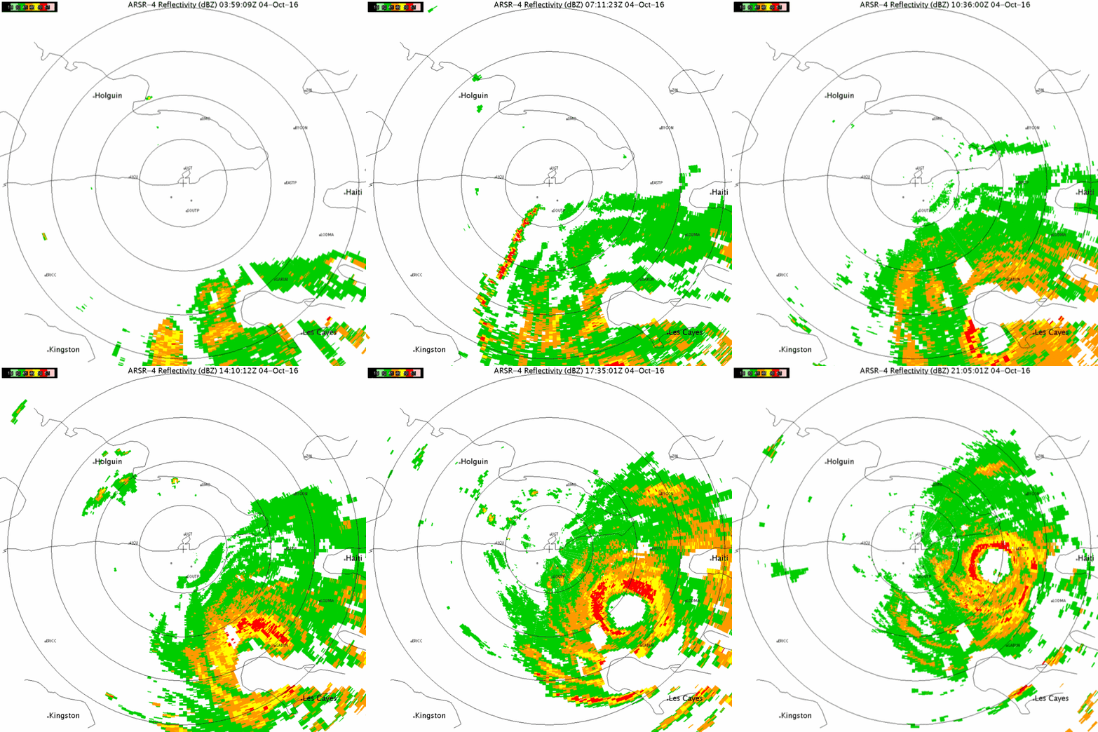
Awesome radar out of Gitmo. Looks like the eyewall is moving on shore now. 5pm nudged a bit closer to FL. NHC has no intensification of Matthew once the hurricane moves into the Atlantic. Kind of surprised with that. Conditions look pretty good to intensify until SW winds aloft from the trough start impacting Matthew. All you folks along the Atlantic coast need to get ready....looks like it could be a close call......MGC
2 likes   

xironman
S2K Supporter
S2K Supporter
Posts: 2522
Joined: Sun Jun 10, 2007 4:53 pm
Location: NoVA

Re: ATL: MATTHEW - Hurricane - Discussion

#5810 Postby xironman » Tue Oct 04, 2016 4:22 pm

Aric Dunn wrote:
xironman wrote:
Aric Dunn wrote:
They have been using dropsonde data for advisories this entire system as well as many others.

the upgrade to Cat 5 was due to multiple dropsondes.


Sure, point me to the discussion where they use dropsonde data for sustained winds.


looking for the cat five one.. but here when it was still intensifying

"Matthew has continued to rapidly strengthen at a remarkable rate
today. A NOAA Hurricane Hunter aircraft recently reported a peak
SFMR wind of 116 kt and flight-level winds of 121 kt. A recent
dropsonde from the aircraft indicated that surface winds are around
120 kt. Based on all of these data, the initial intensity is set to
120 kt,
an increase of 55 kt in the last 24 hours. The latest
pressure estimate from the aircraft is 949 mb, a drop of 44 mb since
this time yesterday."


Notice how they used the SFMR first and the dropsonde to back it up, it is secondary data
Last edited by xironman on Tue Oct 04, 2016 4:23 pm, edited 1 time in total.
0 likes   

User avatar
Nimbus
Category 5
Category 5
Posts: 5333
Joined: Mon Jul 19, 2004 10:54 am

Re: ATL: MATTHEW - Hurricane - Discussion

#5811 Postby Nimbus » Tue Oct 04, 2016 4:22 pm

From the 5 PM advisory

"2. When a hurricane is forecast to take a track roughly parallel
to a coastline, as Matthew is forecast to do from Florida through
South Carolina, it becomes very difficult to estimate impacts this
far in advance. For example, only a small deviation of the track to
the left of the NHC forecast could bring the core of a major
hurricane onshore, while a small deviation to the right could keep
all of the hurricane-force winds offshore. It will likely take
another day or so for the potential impacts of Matthew in the United
States to clarify."

Gonzo found slightly more ridging recently but I think the general expectation (at this time) is that at least the very worst core winds may stay off shore along the east coast of Florida.
0 likes   

Michele B
S2K Supporter
S2K Supporter
Posts: 1115
Joined: Thu Aug 25, 2016 8:08 am
Location: SWFL

Re: ATL: MATTHEW - Hurricane - Discussion

#5812 Postby Michele B » Tue Oct 04, 2016 4:22 pm

GCANE wrote:The last Euro has to be about the most insane forcast I have seen.

Takes out KSC, Savannah, and the southern burbs of Charleston.
Goes back into the Bahamas.
Then another run across Florida into the GOM.


Just got home from work.

WTH DID I miss?!?!?!
Can someone give me the link to THAT model?
0 likes   
Cleo - 1964, Betsy - 1965, David - 1979, Andrew - 1992, Charlie (Francis, Ivan, Jeanne) - 2004, Irma - 2017, Ian - 2022

User avatar
NDG
S2K Supporter
S2K Supporter
Posts: 15456
Joined: Sun Jul 09, 2006 10:14 pm
Location: Orlando, FL

Re: ATL: MATTHEW - Hurricane - Discussion

#5813 Postby NDG » Tue Oct 04, 2016 4:25 pm

Looks like Mike Theiss in Baracoa is going to be right on the northern eyewall, the hotel he is kind of old hope it can hold on.

Image
0 likes   

ozonepete
Professional-Met
Professional-Met
Posts: 4743
Joined: Mon Sep 07, 2009 3:23 pm
Location: From Ozone Park, NYC / Now in Brooklyn, NY

Re: ATL: MATTHEW - Hurricane - Discussion

#5814 Postby ozonepete » Tue Oct 04, 2016 4:25 pm

Michele B wrote:
GCANE wrote:The last Euro has to be about the most insane forcast I have seen.

Takes out KSC, Savannah, and the southern burbs of Charleston.
Goes back into the Bahamas.
Then another run across Florida into the GOM.


Just got home from work.

WTH DID I miss?!?!?!
Can someone give me the link to THAT model?


It was a bad run. They probably had a system malfunction and so it misread the data or wrong data.
1 likes   

floridasun78
Category 5
Category 5
Posts: 3755
Joined: Sun May 17, 2009 10:16 pm
Location: miami fl

Re: ATL: MATTHEW - Hurricane - Discussion

#5815 Postby floridasun78 » Tue Oct 04, 2016 4:26 pm

ok i talk to miami weather service their told me that their waiting to see if models change more too wnw we could see hurr watch in dade that why broward have hurr watch now
1 likes   

SeGaBob

Re: ATL: MATTHEW - Hurricane - Discussion

#5816 Postby SeGaBob » Tue Oct 04, 2016 4:27 pm

Local met said it shifted east and "there might be additional east shifts." That didn't sound right...
1 likes   

Mouton
S2K Supporter
S2K Supporter
Posts: 222
Age: 79
Joined: Sat Jul 30, 2011 8:13 am
Location: Amelia Island Florida

Re: ATL: MATTHEW - Hurricane - Discussion

#5817 Postby Mouton » Tue Oct 04, 2016 4:28 pm

psyclone wrote:
ronjon wrote:frankly shocked the NHC didn't shift the track further west.


they've got time to make their baby steps as needed. Look at those wind probs now...Orlando with a 70% chance of ts winds IIRC....As it stands now central Florida east of US 27 is going to see some decent wind from this...and the coast looks like hammer time. Look at Palm Beach's odds.... :eek: Time to channel understandable anxiety into constructive preps..


YUP, here on Amelia Island got about half the shutters up so far and will have most of the rest up by dark. Have relo plans set for Valdosta Ga, probably overkill but I want a decent life where staying.
Got gas for generator, comfort foods and some reading materials for time without power which could be significant. Medical supplies, water, enough ammo to hold off a division too so as set as can be.

Spoke to one of my Rotary buddies about my not being present at meeting tomorrow and he wondered why. When I said this storm is too strong to trifle with he responded "what storm". I guess some don't keep up on the news. So, if you know anyone that seem unaware of the situation in Fla give them a jog just to up their sensitivity.

Good luck to all.
1 likes   

User avatar
wxmann_91
Category 5
Category 5
Posts: 8013
Age: 34
Joined: Fri Jul 15, 2005 2:49 pm
Location: Southern California
Contact:

Re: ATL: MATTHEW - Hurricane - Discussion

#5818 Postby wxmann_91 » Tue Oct 04, 2016 4:29 pm

ozonepete wrote:
Michele B wrote:
GCANE wrote:The last Euro has to be about the most insane forcast I have seen.

Takes out KSC, Savannah, and the southern burbs of Charleston.
Goes back into the Bahamas.
Then another run across Florida into the GOM.


Just got home from work.

WTH DID I miss?!?!?!
Can someone give me the link to THAT model?


It was a bad run. They probably had a system malfunction and so it misread the data or wrong data.


Source for this? I was under the impression it was a perfectly valid run.
0 likes   

OntarioEggplant
Category 1
Category 1
Posts: 312
Joined: Sun Aug 07, 2016 11:16 am

Re: ATL: MATTHEW - Hurricane - Discussion

#5819 Postby OntarioEggplant » Tue Oct 04, 2016 4:29 pm

ozonepete wrote:
Michele B wrote:
GCANE wrote:The last Euro has to be about the most insane forcast I have seen.

Takes out KSC, Savannah, and the southern burbs of Charleston.
Goes back into the Bahamas.
Then another run across Florida into the GOM.


Just got home from work.

WTH DID I miss?!?!?!
Can someone give me the link to THAT model?


It was a bad run. They probably had a system malfunction and so it misread the data or wrong data.


What? The UKMET had a very similar solution. It's a weird solution, but please don't call it a "bad run from a system malfunction" when that is not the case.
1 likes   

snowpocalypse
Tropical Low
Tropical Low
Posts: 39
Joined: Sat Sep 17, 2016 7:24 pm
Location: GA

Re: ATL: MATTHEW - Hurricane - Discussion

#5820 Postby snowpocalypse » Tue Oct 04, 2016 4:30 pm

SeGaBob wrote:Looks like it shifted east up here.


Ga/sc coast? Did you notice the slower movement? Shifted about 6 hours behind. Hopefully that holds true and keeps it off the coast at SC/NC border
0 likes   


Return to “2016”

Who is online

Users browsing this forum: No registered users and 8 guests