ATL: MATTHEW - Post-Tropical - Discussion
Moderator: S2k Moderators
-
Sav_hurricane_hunter
- Tropical Low

- Posts: 25
- Joined: Fri Sep 30, 2016 11:29 pm
Re: ATL: MATTHEW - Hurricane - Discussion
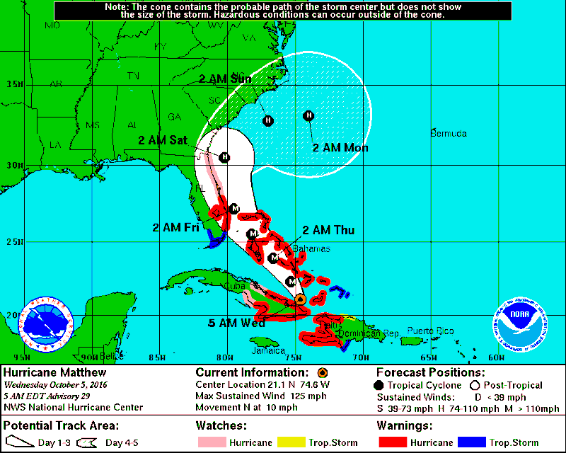
So with it moved east in 5am track does this mean Savannah, Ga is in the clear as far as bad weather?
0 likes

Re: ATL: MATTHEW - Hurricane - Discussion
Latest microwave

1 likes
Personal Forecast Disclaimer:
The posts in this forum are NOT official forecast and should not be used as such. They are just the opinion of the poster and may or may not be backed by sound meteorological data. For official information, please refer to the NHC and NWS products.
The posts in this forum are NOT official forecast and should not be used as such. They are just the opinion of the poster and may or may not be backed by sound meteorological data. For official information, please refer to the NHC and NWS products.
Re: ATL: MATTHEW - Hurricane - Discussion
I was hoping that the discussion would get into the possibilities of the loops, but since it is over five days they smartly stayed away.
0 likes

Re: ATL: MATTHEW - Hurricane - Discussion
JKingTampa wrote:
Very slightly east, but I think the real forecast track will come to better agreement once the land interaction has completely finished and we see how the storm continues on during it's restrengthening. Being near Tampa all east shifts bring us out of any impact whatsoever but I have a feeling it could be more on the western side of that track during landfall which would bring at least Tropical Storm conditions to most of our state.
Through the next 60-72 hrs the margin of error by both the GFS and Euro is around 50-70 miles, so at the most westward shift that I see happening is interior central FL so a track towards the west coast of FL is looking less likely as time gets near.
0 likes

Re: ATL: MATTHEW - Hurricane - Discussion
I would think you will have a better idea in 24 hours. Further from the se coast, but closer to the south coast-
The 0000 UTC GFS has shifted slightly west of the previous run, and is now close to the UKMET and ECWMF tracks. The new NHC forecast is very similar to the previous advisory through 72 hours, and shows a track very close to much of the east coast of the Florida peninsula. Only a slight deviation to the west of forecast track could result in landfall in Florida. The last few iterations of the global models have been trending toward a solution in which the trough is not deep enough to completely lift Matthew northeastward. As a result, the NHC track has been shifted significantly southward at day 5, but it remains well north of the GFS, ECMWF, and UKMET models
The 0000 UTC GFS has shifted slightly west of the previous run, and is now close to the UKMET and ECWMF tracks. The new NHC forecast is very similar to the previous advisory through 72 hours, and shows a track very close to much of the east coast of the Florida peninsula. Only a slight deviation to the west of forecast track could result in landfall in Florida. The last few iterations of the global models have been trending toward a solution in which the trough is not deep enough to completely lift Matthew northeastward. As a result, the NHC track has been shifted significantly southward at day 5, but it remains well north of the GFS, ECMWF, and UKMET models
Sav_hurricane_hunter wrote:So with it moved east in 5am track does this mean Savannah, Ga is in the clear as far as bad weather?
0 likes
-
eastcoastFL

- Category 5

- Posts: 3996
- Age: 44
- Joined: Thu Apr 12, 2007 12:29 pm
- Location: Palm City, FL
Re: ATL: MATTHEW - Hurricane - Discussion

According to the 5am track is looks like Hurricane force winds may cover much of the Florida east coast.
0 likes
Personal Forecast Disclaimer:
The posts in this forum are NOT official forecast and should not be used as such. They are just the opinion of the poster and may or may not be backed by sound meteorological data. They are NOT endorsed by any professional institution or storm2k.org. For official information, please refer to the NHC and NWS products.
The posts in this forum are NOT official forecast and should not be used as such. They are just the opinion of the poster and may or may not be backed by sound meteorological data. They are NOT endorsed by any professional institution or storm2k.org. For official information, please refer to the NHC and NWS products.
Re: ATL: MATTHEW - Hurricane - Discussion
There's going to be a lot of upset people in S.C. at their Governor for calling for evacuations so early if the trend calls for no S.C. landfall. But is better to be safe than sorry, IMO.
The 0000 UTC GFS has shifted slightly west of the
previous run, and is now close to the UKMET and ECWMF tracks. The
new NHC forecast is very similar to the previous advisory through
72 hours, and shows a track very close to much of the east coast
of the Florida peninsula. Only a slight deviation to the west of
forecast track could result in landfall in Florida. The last few
iterations of the global models have been trending toward a solution
in which the trough is not deep enough to completely lift Matthew
northeastward. As a result, the NHC track has been shifted
significantly southward at day 5, but it remains well north of
the GFS, ECMWF, and UKMET models.
Last edited by NDG on Wed Oct 05, 2016 4:25 am, edited 1 time in total.
0 likes
Re: ATL: MATTHEW - Hurricane - Discussion
http://forecast.weather.gov/MapClick.ph ... _TC9n0pBoP
 well, today according to our weather from the nws we will receive hurricane conditions, then tropical storm.
here in Palm Beach county near Royal Palm Beach. Hope they see this to get it corrected. May cause some heart attacks!
here in Palm Beach county near Royal Palm Beach. Hope they see this to get it corrected. May cause some heart attacks!
0 likes
-
JKingTampa

- Tropical Storm

- Posts: 101
- Joined: Wed Sep 10, 2014 8:16 pm
- Location: St. Petersburg, FL
Re: ATL: MATTHEW - Hurricane - Discussion
artist wrote:http://forecast.weather.gov/MapClick.php?lat=26.79403915600045&lon=-80.26748829499968#.V_TC9n0pBoP
here in Palm Beach county near Royal Palm Beach. Hope they see this to get it corrected. May cause some heart attacks!
We have Tropical Storm Conditions in the forecast from NWS all the way here on the east coast near Tampa.
0 likes
Re: ATL: MATTHEW - Hurricane - Discussion
Latest AFD from our Melbourne NWS office:
http://forecast.weather.gov/product.php ... glossary=1
Thu-Fri...
Latest official NHC forecast track of Hurricane Matthew has trended
toward the west, and closer to the FL East coast. This trend is
backed up by the 00Z runs of GFS/ECMWF, which are in good agreement
in depicting a rather ominous solution, bringing the center of major
Hurricane Matthew very close to the coast of East Central Florida
Thursday night into Friday.
This means conditions will deteriorate from south to north as
Matthew approaches on Thursday, with latest guidance suggesting the
arrival of Tropical Storm force winds along the Treasure Coast by
Thursday afternoon...then worsening and spreading north and west
overnight into Friday. The strength and close approach to the
coastline by Matthew suggests hurricane force gusts and hurricane
force sustained winds are becoming more likely Thursday night into
Friday... especially for the coastal counties. Along with damaging
winds and rain squalls, there will be a chance of flooding rains and
significant beach erosion potential. Specific hazards will be
addressed in Hurricane Local Statements from the National Weather
Service in Melbourne.
http://forecast.weather.gov/product.php ... glossary=1
0 likes
-
jlauderdal
- S2K Supporter

- Posts: 7240
- Joined: Wed May 19, 2004 5:46 am
- Location: NE Fort Lauderdale
- Contact:
Re: ATL: MATTHEW - Hurricane - Discussion
NDG wrote:There's going to be a lot of upset people in S.C. at their Governor for calling for evacuations so early if the trend calls for no S.C. landfall. But is better to be safe than sorry, IMO.The 0000 UTC GFS has shifted slightly west of the
previous run, and is now close to the UKMET and ECWMF tracks. The
new NHC forecast is very similar to the previous advisory through
72 hours, and shows a track very close to much of the east coast
of the Florida peninsula. Only a slight deviation to the west of
forecast track could result in landfall in Florida. The last few
iterations of the global models have been trending toward a solution
in which the trough is not deep enough to completely lift Matthew
northeastward. As a result, the NHC track has been shifted
significantly southward at day 5, but it remains well north of
the GFS, ECMWF, and UKMET models.
i posted yesterday seemed pre mature for that...anyway thats their decision the problem it causes complacency..it shouldnt take 3 days to evacuate areas in sc..
2 likes
Re: ATL: MATTHEW - Hurricane - Discussion
Wow! Hopefully it doesn't move much more west.
Yeah, according to the NHC we won't be getting hurricane force until late Thursday, early Friday, so our NWS office screwed up. We have them Wed night instead.
Yeah, according to the NHC we won't be getting hurricane force until late Thursday, early Friday, so our NWS office screwed up. We have them Wed night instead.
JKingTampa wrote:artist wrote:http://forecast.weather.gov/MapClick.php?lat=26.79403915600045&lon=-80.26748829499968#.V_TC9n0pBoP
here in Palm Beach county near Royal Palm Beach. Hope they see this to get it corrected. May cause some heart attacks!
We have Tropical Storm Conditions in the forecast from NWS all the way here on the east coast near Tampa.
Last edited by artist on Wed Oct 05, 2016 4:45 am, edited 1 time in total.
0 likes
-
jlauderdal
- S2K Supporter
- Posts: 7240
- Joined: Wed May 19, 2004 5:46 am
- Location: NE Fort Lauderdale
- Contact:
Re: ATL: MATTHEW - Hurricane - Discussion
there will be plenty of discussion about loops here and shifts, trends and everything else you can imaginexironman wrote:I was hoping that the discussion would get into the possibilities of the loops, but since it is over five days they smartly stayed away.
0 likes
Re: ATL: MATTHEW - Hurricane - Discussion
Well, at least they were on the ball. PBC EM is still twiddling their thumbs-a bad habit they have in hurricanes- still in the lowest alert level 3. Nothing has been announced here at all.
jlauderdal wrote:NDG wrote:There's going to be a lot of upset people in S.C. at their Governor for calling for evacuations so early if the trend calls for no S.C. landfall. But is better to be safe than sorry, IMO.The 0000 UTC GFS has shifted slightly west of the
previous run, and is now close to the UKMET and ECWMF tracks. The
new NHC forecast is very similar to the previous advisory through
72 hours, and shows a track very close to much of the east coast
of the Florida peninsula. Only a slight deviation to the west of
forecast track could result in landfall in Florida. The last few
iterations of the global models have been trending toward a solution
in which the trough is not deep enough to completely lift Matthew
northeastward. As a result, the NHC track has been shifted
significantly southward at day 5, but it remains well north of
the GFS, ECMWF, and UKMET models.
i posted yesterday seemed pre mature for that...anyway thats their decision the problem it causes complacency..it shouldnt take 3 days to evacuate areas in sc..
0 likes
-
jlauderdal
- S2K Supporter
- Posts: 7240
- Joined: Wed May 19, 2004 5:46 am
- Location: NE Fort Lauderdale
- Contact:
Re: ATL: MATTHEW - Hurricane - Discussion
artist wrote:Well, at least they were on the ball. PBC EM is still twiddling their thumbs-a bad habit they have in hurricanes- still in the lowest alert level 3. Nothing has been announced here at all.jlauderdal wrote:NDG wrote:There's going to be a lot of upset people in S.C. at their Governor for calling for evacuations so early if the trend calls for no S.C. landfall. But is better to be safe than sorry, IMO.
i posted yesterday seemed pre mature for that...anyway thats their decision the problem it causes complacency..it shouldnt take 3 days to evacuate areas in sc..
they will decide on evacuations today..all day today and first half tomorrow although not ideal to evacuate tomorrow...its very expensive to evacuate so it seems like they are cutting it close but they have too
0 likes
-
Scorpion
Re: ATL: MATTHEW - Hurricane - Discussion
Looking forward to this, Jupiter appears to be ground zero for highest potential winds but I'll be ready to chase anywhere up the coast. Hermine was a fun first timer, almost was hit with the surge, engine flooded, thankfully I was able to get out.
0 likes

Re: ATL: MATTHEW - Hurricane - Discussion
Wow, the cone changed. But it still looks poised to parallel the whole southeastern US coast.
0 likes
Igor 2010, Sandy 2012, Fay 2014, Gonzalo 2014, Joaquin 2015, Nicole 2016, Humberto 2019, Imelda 2025
I am only a tropical weather enthusiast. My predictions are not official and may or may not be backed by sound meteorological data. For official information, please refer to the NHC and NWS products.
I am only a tropical weather enthusiast. My predictions are not official and may or may not be backed by sound meteorological data. For official information, please refer to the NHC and NWS products.
-
eastcoastFL
- Category 5
- Posts: 3996
- Age: 44
- Joined: Thu Apr 12, 2007 12:29 pm
- Location: Palm City, FL
Re: ATL: MATTHEW - Hurricane - Discussion
http://www.ssd.noaa.gov/goes/east/carb/h5-loop-vis.html
Matt is a big boy! Appears it may be moving slightly NW. But I could be wrong...
Matt is a big boy! Appears it may be moving slightly NW. But I could be wrong...
0 likes
Personal Forecast Disclaimer:
The posts in this forum are NOT official forecast and should not be used as such. They are just the opinion of the poster and may or may not be backed by sound meteorological data. They are NOT endorsed by any professional institution or storm2k.org. For official information, please refer to the NHC and NWS products.
The posts in this forum are NOT official forecast and should not be used as such. They are just the opinion of the poster and may or may not be backed by sound meteorological data. They are NOT endorsed by any professional institution or storm2k.org. For official information, please refer to the NHC and NWS products.
Re: ATL: MATTHEW - Hurricane - Discussion
mourninbrew wrote:sbcc wrote:Madpoodle wrote:
It is. But I can also tell you from dealing with FPL EVERY day, the lineman will go right past you if they see a generator running and no transfer switch. Pick your poison, so far every time I have pulled the meter the lineman have been appreciative, and I am not in jail..
OK. Maybe you should include that in your article.
I am a lineman, on the way to the east coast... Pull the can, nobody will say anything. And it may save an apprentices life or some lineman that's not on top of his game... You know working to turn your power on 17 hours a day and then some. Just my two cents! Cheers
Be safe man, and thank you for the help over here we're gonna need it!
2 likes
Opinions expressed by this poster are purely conjecture on his part and have no basis in reality. As such, taking any advice from me would be foolish, and potentially deadly.
-
eastcoastFL
- Category 5
- Posts: 3996
- Age: 44
- Joined: Thu Apr 12, 2007 12:29 pm
- Location: Palm City, FL
Re: ATL: MATTHEW - Hurricane - Discussion
This is my local hurricane statement from NWS for Martin County
POTENTIAL IMPACTS
-----------------
* WIND:
PREPARE FOR LIFE-THREATENING WIND HAVING POSSIBLE DEVASTATING IMPACTS
ACROSS THE COASTAL COMMUNITIES OF EAST CENTRAL FLORIDA. POTENTIAL
IMPACTS IN THIS AREA
INCLUDE:
- STRUCTURAL DAMAGE TO STURDY BUILDINGS, SOME WITH COMPLETE ROOF
AND WALL FAILURES. COMPLETE DESTRUCTION OF MOBILE HOMES. DAMAGE
GREATLY ACCENTUATED BY LARGE AIRBORNE PROJECTILES. LOCATIONS
MAY BE UNINHABITABLE FOR WEEKS OR MONTHS.
- NUMEROUS LARGE TREES SNAPPED OR UPROOTED ALONG WITH FENCES AND
ROADWAY SIGNS BLOWN OVER.
- MANY ROADS IMPASSABLE FROM LARGE DEBRIS, AND MORE WITHIN URBAN
OR HEAVILY WOODED PLACES. MANY BRIDGES, CAUSEWAYS, AND ACCESS
ROUTES IMPASSABLE.
- WIDESPREAD POWER AND COMMUNICATIONS OUTAGES.
ALSO, PREPARE FOR LIFE-THREATENING WIND HAVING POSSIBLE SIGNIFICANT
TO EXTENSIVE IMPACTS ACROSS INLAND AREAS.
* SURGE:
PREPARE FOR LIFE-THREATENING SURGE HAVING POSSIBLE SIGNIFICANT
IMPACTS ACROSS THE BARRIER ISLANDS OF EAST CENTRAL FLORIDA.
POTENTIAL IMPACTS IN THIS AREA INCLUDE:
- AREAS OF INUNDATION WITH STORM SURGE FLOODING ACCENTUATED BY
WAVES. DAMAGE TO SEVERAL BUILDINGS, MAINLY NEAR THE COAST.
- SECTIONS OF NEAR-SHORE ESCAPE ROUTES AND SECONDARY ROADS BECOME
WEAKENED OR WASHED OUT, ESPECIALLY IN USUALLY VULNERABLE LOW
SPOTS.
- MAJOR BEACH EROSION WITH HEAVY SURF BREACHING DUNES. STRONG AND
NUMEROUS RIP CURRENTS.
- MODERATE DAMAGE TO MARINAS, DOCKS, BOARDWALKS, PIERS, AND OTHER
COASTAL STRUCTURES. SEVERAL SMALL CRAFT BROKEN AWAY FROM
MOORINGS, ESPECIALLY IN UNPROTECTED ANCHORAGES.
* FLOODING RAIN:
PREPARE FOR DANGEROUS RAINFALL FLOODING HAVING POSSIBLE SIGNIFICANT
IMPACTS ACROSS MOST OF EAST CENTRAL FLORIDA. POTENTIAL IMPACTS
INCLUDE:
- MODERATE RAINFALL FLOODING MAY PROMPT SEVERAL EVACUATIONS AND
RESCUES.
- RIVERS MAY QUICKLY BECOME SWOLLEN AND OVERSPILL THEIR BANKS,
ESPECIALLY IN USUALLY VULNERABLE SPOTS. SMALL STREAMS, CREEKS,
CANALS, AND DITCHES WILL OVERFLOW.
- FLOOD WATERS CAN ENTER SOME STRUCTURES OR WEAKEN FOUNDATIONS.
SEVERAL PLACES MAY EXPERIENCE EXPANDED AREAS OF RAPID
INUNDATION IN LOW-LYING SPOTS, AND POOR DRAINAGE
AREAS. SOME STREETS AND PARKING LOTS TAKE ON MOVING WATER AS
STORM DRAINS AND RETENTION PONDS OVERFLOW. DRIVING CONDITIONS
WILL BECOME HAZARDOUS WITH SOME ROAD AND BRIDGE CLOSURES.
* TORNADOES:
PREPARE FOR A TORNADO EVENT HAVING POSSIBLE LIMITED IMPACTS ACROSS
EAST CENTRAL FLORIDA. POTENTIAL IMPACTS INCLUDE:
- THE OCCURRENCE OF ISOLATED TORNADOES CAN HINDER THE EXECUTION
OF EMERGENCY PLANS DURING TROPICAL EVENTS.
- A FEW PLACES MAY EXPERIENCE TORNADO DAMAGE, ALONG WITH POWER
AND COMMUNICATIONS DISRUPTIONS.
0 likes
Personal Forecast Disclaimer:
The posts in this forum are NOT official forecast and should not be used as such. They are just the opinion of the poster and may or may not be backed by sound meteorological data. They are NOT endorsed by any professional institution or storm2k.org. For official information, please refer to the NHC and NWS products.
The posts in this forum are NOT official forecast and should not be used as such. They are just the opinion of the poster and may or may not be backed by sound meteorological data. They are NOT endorsed by any professional institution or storm2k.org. For official information, please refer to the NHC and NWS products.
Who is online
Users browsing this forum: No registered users and 41 guests