Models can change back and forth,to me it is most interesting that the experts at the NHC are saying that conditions are conducive
for development
ATL: HERMINE - Models
Moderator: S2k Moderators
-
AtlanticWind

- S2K Supporter

- Posts: 1898
- Age: 67
- Joined: Sun Aug 08, 2004 9:57 pm
- Location: Plantation,Fla
Re: ATL: INVEST 99L - Models
0 likes
-
weathaguyry

- Category 5

- Posts: 1273
- Age: 22
- Joined: Wed Jun 15, 2016 5:16 am
- Location: Long Island, NY
Re: ATL: INVEST 99L - Models
6z GFS is starting to come out
0 likes
My posts are only my opinions and NOT official forecasts. For official forecasts, consult the National Hurricane Center or the National Weather Service.
Irene 11', Sandy 12', Fay 20’, Isaias 20’, Elsa 21’, Henri 21’, Ida 21’
Irene 11', Sandy 12', Fay 20’, Isaias 20’, Elsa 21’, Henri 21’, Ida 21’
Re: ATL: INVEST 99L - Models
06Z GFS showed very weak system reaching almost reaching FL but retrograding NE...
1 likes
-
cycloneye

- Admin

- Posts: 149516
- Age: 69
- Joined: Thu Oct 10, 2002 10:54 am
- Location: San Juan, Puerto Rico
Re: ATL: INVEST 99L - Models
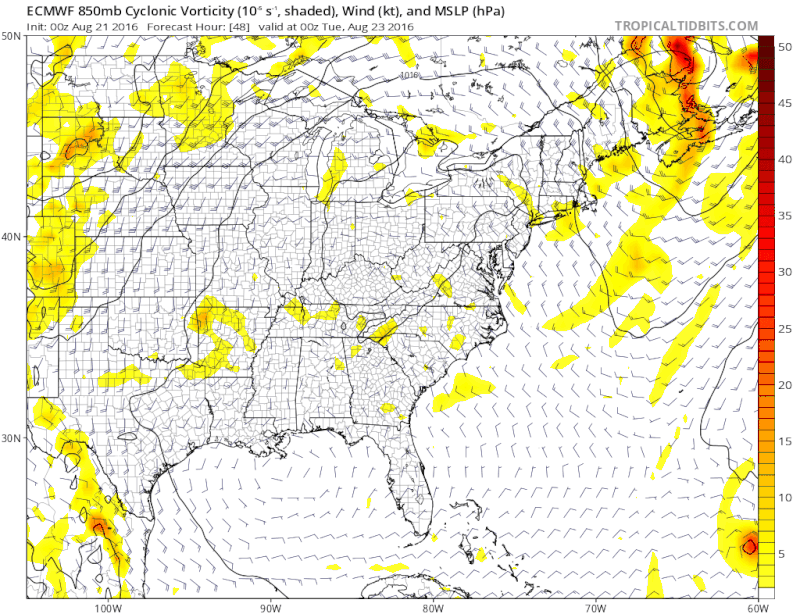
06z develops north of Bahamas but no threat to Florida.

0 likes
Visit the Caribbean-Central America Weather Thread where you can find at first post web cams,radars
and observations from Caribbean basin members Click Here
and observations from Caribbean basin members Click Here
-
cycloneye
- Admin
- Posts: 149516
- Age: 69
- Joined: Thu Oct 10, 2002 10:54 am
- Location: San Juan, Puerto Rico
Re: ATL: INVEST 99L - Models
Moving NE at 288 hours as a Hurricane.

0 likes
Visit the Caribbean-Central America Weather Thread where you can find at first post web cams,radars
and observations from Caribbean basin members Click Here
and observations from Caribbean basin members Click Here


-
JtSmarts

- S2K Supporter
- Posts: 1442
- Age: 40
- Joined: Thu Jul 10, 2003 1:29 pm
- Location: Columbia, South Carolina
Re: ATL: INVEST 99L - Models
Looks like the development of 90 opens things up for 99 to move more northerly instead of into the SE US.
0 likes
-
TheStormExpert
Re: ATL: INVEST 99L - Models
JtSmarts wrote:Looks like the development of 90 opens things up for 99 to move more northerly instead of into the SE US.
Not necessarily, 99L looks to start moving west some towards the Northern Bahamas and Florida before being picked up by an approaching shortwave in Canada.
Still 10 days out though.
0 likes
-
Dean4Storms
- S2K Supporter
- Posts: 6358
- Age: 63
- Joined: Sun Aug 31, 2003 1:01 pm
- Location: Miramar Bch. FL

-
USTropics
- Professional-Met

- Posts: 2739
- Joined: Sun Aug 12, 2007 3:45 am
- Location: Florida State University
Re: ATL: INVEST 99L - Models
Some of the 00z guidance
00z Multi-Model Diagnostic Comparison:

00z Ensemble Tropical Genesis Prob %:

00z Multi-Model Diagnostic Comparison:
00z Ensemble Tropical Genesis Prob %:
0 likes
-
JtSmarts
- S2K Supporter
- Posts: 1442
- Age: 40
- Joined: Thu Jul 10, 2003 1:29 pm
- Location: Columbia, South Carolina
Re: ATL: INVEST 99L - Models
TheStormExpert wrote:JtSmarts wrote:Looks like the development of 90 opens things up for 99 to move more northerly instead of into the SE US.
Not necessarily, 99L looks to start moving west some towards the Northern Bahamas and Florida before being picked up by an approaching shortwave in Canada.
Still 10 days out though.
Going to be very interesting to watch all this unfold, that shortwave wasn't there in previous runs (over the last two days) was it?
0 likes
-
TheStormExpert
Re: ATL: INVEST 99L - Models
JtSmarts wrote:TheStormExpert wrote:JtSmarts wrote:Looks like the development of 90 opens things up for 99 to move more northerly instead of into the SE US.
Not necessarily, 99L looks to start moving west some towards the Northern Bahamas and Florida before being picked up by an approaching shortwave in Canada.
Still 10 days out though.
Going to be very interesting to watch all this unfold, that shortwave wasn't there in previous runs (over the last two days) was it?
GEFS Ensembles aren't bullish so I wouldn't buy into this at all.
0 likes
-
CYCLONE MIKE
- Category 5
- Posts: 2183
- Joined: Tue Aug 31, 2004 6:04 pm
- Location: Gonzales, LA
Re: ATL: INVEST 99L - Models
Buy into which part? that gfs shows this developing as it's moving NE out into the atlantic or showing a trough picking it up? The latest run looks exactly like the 0z Canadian. Weak low heading nw, stalling, then developing as a trough comes in and sweeps it out to sea.
0 likes
This post is NOT AN OFFICIAL FORECAST and should not be used as such. It is just the opinion of the poster and may or may not be backed by sound meteorological data. It is NOT endorsed by any professional institution including storm2k.org. For Official Information please refer to the NHC and NWS products.

Re: ATL: INVEST 99L - Models
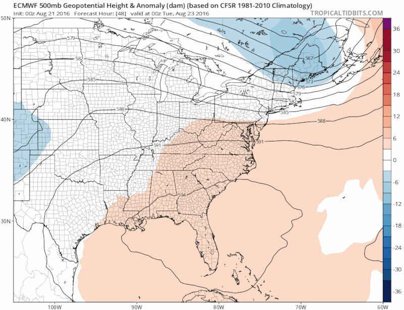
Not sure if anybody noticed that the 0z Euro has Fiona's vorticity absorbing 99L, which has no where to go as it gets trapped underneath under the East Coast Ridge which will be back in full force.
BTW, the Euro dropped its crazy idea of developing a mid and upper level low west of Bermuda, once again, lol.
BTW, the Euro dropped its crazy idea of developing a mid and upper level low west of Bermuda, once again, lol.
1 likes
-
northjaxpro

- S2K Supporter
- Posts: 8900
- Joined: Mon Sep 27, 2010 11:21 am
- Location: Jacksonville, FL
Re: ATL: INVEST 99L - Models
Still about 10 days out, so lots can still change. The latest runs long range are developing a break in the ridge late in the period. This may be the saving grace for Florida and the rest of the CONUS if the trough materializes. HOWEVER, this is a HUGE IF given we are still about 10 days out.
There are simply too many uncertainties folks this far out as you would anticipate. This is why in most instances I usually like to wait until we lock in the 5 to 7 day period to formulate better what the models are doing with these cyclones.
There are simply too many uncertainties folks this far out as you would anticipate. This is why in most instances I usually like to wait until we lock in the 5 to 7 day period to formulate better what the models are doing with these cyclones.
1 likes
NEVER, EVER SAY NEVER in the tropics and weather in general, and most importantly, with life itself!!
________________________________________________________________________________________
Fay 2008 Beryl 2012 Debby 2012 Colin 2016 Hermine 2016 Julia 2016 Matthew 2016 Irma 2017 Dorian 2019
________________________________________________________________________________________
Fay 2008 Beryl 2012 Debby 2012 Colin 2016 Hermine 2016 Julia 2016 Matthew 2016 Irma 2017 Dorian 2019
-
SeGaBob
Re: ATL: INVEST 99L - Models
I think the Gfs has it right this time... A recurve a few hundred miles off of Florida makes sense. The other models will pick up that idea I bet.
Last edited by SeGaBob on Sun Aug 21, 2016 8:03 am, edited 1 time in total.
0 likes
-
northjaxpro
- S2K Supporter
- Posts: 8900
- Joined: Mon Sep 27, 2010 11:21 am
- Location: Jacksonville, FL
Re: ATL: INVEST 99L - Models
1 likes
NEVER, EVER SAY NEVER in the tropics and weather in general, and most importantly, with life itself!!
________________________________________________________________________________________
Fay 2008 Beryl 2012 Debby 2012 Colin 2016 Hermine 2016 Julia 2016 Matthew 2016 Irma 2017 Dorian 2019
________________________________________________________________________________________
Fay 2008 Beryl 2012 Debby 2012 Colin 2016 Hermine 2016 Julia 2016 Matthew 2016 Irma 2017 Dorian 2019
-
Dean4Storms
- S2K Supporter
- Posts: 6358
- Age: 63
- Joined: Sun Aug 31, 2003 1:01 pm
- Location: Miramar Bch. FL
Re: ATL: INVEST 99L - Models
northjaxpro wrote::uarrow: EURO still shows very pronounced ridging, so the GFS idea of developing a trough through the ridge, well I will leave it for you all to debate it.
Yep and the 00z ECM EPS Probability of a TD forming out there east of Florida between 192-240 hours rises to 50% and a TS to 20%.
When I say rising that is compared to the 12Z run before it where the % was 20% chance of a TD forming.
Last edited by Dean4Storms on Sun Aug 21, 2016 8:13 am, edited 2 times in total.
0 likes
Re: ATL: INVEST 99L - Models
northjaxpro wrote::uarrow: EURO still shows very pronounced ridging, so the GFS idea of developing a trough through the ridge, well I will leave it for you all to debate it.
Through day 10 both the GFS and Euro are fairly close, the both show the ridge across the eastern US, through day 7 they both have in similar position, days 7-10 the Euro has is a bit closer centered over the east coast while the GFS has it over the TN valley, but since the Euro doesn't go past 10 days we don't know if it agrees with the GFS of developing a large trough across the eastern US in the 10-14 day range, so there's nothing to debate on
0 likes
-
Blown Away

- S2K Supporter
- Posts: 10253
- Joined: Wed May 26, 2004 6:17 am
Re: ATL: INVEST 99L - Models

12z Intensity Guidance.

06z Intensity Guidance.
0 likes
Hurricane Eye Experience: David 79, Irene 99, Frances 04, Jeanne 04, Wilma 05… Hurricane Brush Experience: Andrew 92, Erin 95, Floyd 99, Matthew 16, Irma 17, Ian 22, Nicole 22…
Who is online
Users browsing this forum: No registered users and 31 guests