ATL: HERMINE - Post-Tropical - Discussion
Moderator: S2k Moderators
-
Aric Dunn
- Category 5

- Posts: 21238
- Age: 43
- Joined: Sun Sep 19, 2004 9:58 pm
- Location: Ready for the Chase.
- Contact:
Re: ATL: HERMINE - Tropical Storm - Discussion
and yes still flying in but because of the last minute flight i may be too late. ill still follow it inland a little just because.
1 likes
Note: If I make a post that is brief. Please refer back to previous posts for the analysis or reasoning. I do not re-write/qoute what my initial post said each time.
If there is nothing before... then just ask
Space & Atmospheric Physicist, Embry-Riddle Aeronautical University,
I believe the sky is falling...
If there is nothing before... then just ask
Space & Atmospheric Physicist, Embry-Riddle Aeronautical University,
I believe the sky is falling...
-
SouthDadeFish

- Professional-Met

- Posts: 2836
- Joined: Thu Sep 23, 2010 2:54 pm
- Location: Miami, FL
- Contact:
Re: ATL: HERMINE - Tropical Storm - Discussion
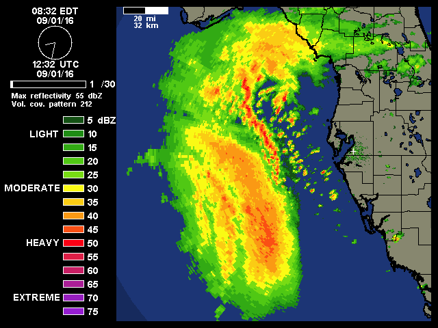
The inner-core is much better defined on this last pass. If the eyewall can close off then I think intensification will resume.
2 likes

Re: ATL: HERMINE - Tropical Storm - Discussion
I know nothing.
But, I am stunned that they only found 991 and 60ish.
But, I am stunned that they only found 991 and 60ish.
0 likes
Re: ATL: HERMINE - Tropical Storm - Discussion
Recon is flying at 850 mb so a 0.8 conversion factor should be applied to flight-level winds. A blend of the flight-level winds and SFMR does not provide enough evidence for an intensity of 60 knots at the moment.
1 likes
Personal Forecast Disclaimer:
The posts in this forum are NOT official forecast and should not be used as such. They are just the opinion of the poster and may or may not be backed by sound meteorological data. They are NOT endorsed by any professional institution or storm2k.org. For official information, please refer to RSMC and NWS products.
The posts in this forum are NOT official forecast and should not be used as such. They are just the opinion of the poster and may or may not be backed by sound meteorological data. They are NOT endorsed by any professional institution or storm2k.org. For official information, please refer to RSMC and NWS products.

Re: ATL: HERMINE - Tropical Storm - Discussion
SEASON_CANCELED wrote:Is the body of this storm offshore Saint Pete move into the area or is just going to go north?
Doesn't take a rocket scientist to see that is heading towards Tampa Bay.
0 likes

Re: ATL: HERMINE - Tropical Storm - Discussion
Best the western semicircle has looked so far.

3 likes
-
HurricaneBelle

- S2K Supporter

- Posts: 1209
- Joined: Sun Aug 27, 2006 6:12 pm
- Location: Clearwater, FL
Re: ATL: HERMINE - Tropical Storm - Discussion
Those discrete cells on the right approaching the west coast in the right front quadrant are generally the most likely to contain spin-ups.
0 likes
-
cycloneye

- Admin

- Posts: 149559
- Age: 69
- Joined: Thu Oct 10, 2002 10:54 am
- Location: San Juan, Puerto Rico
Re: ATL: HERMINE - Advisories
BULLETIN
TROPICAL STORM HERMINE INTERMEDIATE ADVISORY NUMBER 15A
NWS NATIONAL HURRICANE CENTER MIAMI FL AL092016
700 AM CDT THU SEP 01 2016
...HERMINE STRENGTHENS...
SUMMARY OF 700 AM CDT...1200 UTC...INFORMATION
----------------------------------------------
LOCATION...27.1N 86.2W
ABOUT 195 MI...310 KM SSW OF APALACHICOLA FLORIDA
ABOUT 235 MI...380 KM WSW OF TAMPA FLORIDA
MAXIMUM SUSTAINED WINDS...65 MPH...100 KM/H
PRESENT MOVEMENT...NNE OR 20 DEGREES AT 12 MPH...19 KM/H
MINIMUM CENTRAL PRESSURE...992 MB...29.29 INCHES
WATCHES AND WARNINGS
--------------------
CHANGES WITH THIS ADVISORY:
None.
SUMMARY OF WATCHES AND WARNINGS IN EFFECT:
A Hurricane Warning is in effect for...
* Suwannee River to Mexico Beach
A Hurricane Watch is in effect for...
* Anclote River to Suwannee River
* West of Mexico Beach to Destin
A Tropical Storm Warning is in effect for...
* Anclote River to Suwannee River
* West of Mexico Beach to Destin
* Marineland to South Santee River
A Tropical Storm Watch is in effect for...
* North of South Santee River to Surf City
Interests along the United States east coast elsewhere in North
Carolina should monitor the progress of this system.
For storm information specific to your area, including possible
inland watches and warnings, please monitor products issued by your
local National Weather Service forecast office.
DISCUSSION AND 48-HOUR OUTLOOK
------------------------------
At 700 AM CDT (1200 UTC), the center of Tropical Storm Hermine was
located near latitude 27.1 North, longitude 86.2 West. Hermine is
moving toward the north-northeast near 12 mph (19 km/h), and this
motion with a slight increase in forward speed is expected during
the next day or so. On the forecast track, the center of Hermine
will be near the Florida coast in the warning area tonight or early
Friday.
Maximum sustained winds have increased to near 65 mph (100 km/h)
with higher gusts. Additional strengthening is anticipated, and
Hermine is expected to be a hurricane by the time landfall occurs.
Tropical-storm-force winds extend outward up to 140 miles (220 km)
to the east and southeast of the center.
The estimated minimum central pressure from a NOAA Hurricane Hunter
plane was 992 mb (29.29 inches).
HAZARDS AFFECTING LAND
----------------------
WIND: Hurricane conditions are expected to reach the coast
within the warning area beginning tonight. Winds are expected to
first reach tropical storm strength by this afternoon, making
outside preparations difficult or dangerous. Preparations to
protect life and property should be rushed to completion. Tropical
storm conditions are expected to begin within the warning area along
the Atlantic coast on Friday. Tropical storm conditions are
possible in the tropical storm watch area by Friday night and
Saturday.
STORM SURGE: The combination of a dangerous storm surge and the
tide will cause normally dry areas near the coast to be flooded by
rising waters moving inland from the shoreline. There is a danger
of life-threatening inundation within the next 36 hours along the
Gulf coast of Florida from Aripeka to Indian Pass. For a depiction
of areas at risk, please see the Prototype National Weather Service
Storm Surge Watch/Warning Graphic. Persons located within these
areas should take all necessary actions to protect life and property
from rising water. Promptly follow any instructions, including
evacuation orders, from local officials.
The water could reach the following heights above ground if the
peak surge occurs at the time of high tide...
Destin to Indian Pass...1 to 3 feet
Indian Pass to Chassahowitzka...4 to 7 feet
Chassahowitzka to Aripeka...2 to 4 feet
Aripeka to Bonita Beach...including Tampa Bay...1 to 3 feet
Florida-Georgia line to Cape Fear...1 to 3 feet
The Prototype National Weather Service Storm Surge Watch/Warning
Graphic is a depiction of areas that would qualify for inclusion
under a storm surge watch or warning currently under development by
the National Weather Service and planned for operational use in
2017. This prototype graphic is available at
www.hurricanes.gov/graphics_at4.shtml?wsurge
RAINFALL: Hermine is expected to produce storm total rainfall
accumulations of 5 to 10 inches over portions of northwest Florida
and southern Georgia through Friday, with possible isolated maximum
amounts of 20 inches. On Friday and Saturday, Hermine is expected to
produce totals of 4 to 8 inches with local amounts of 10 inches
possible across portions of eastern Georgia, South Carolina, and
eastern North Carolina through Saturday. These rains may cause
life-threatening flash flooding.
TORNADOES: A few tornadoes are possible this afternoon into Friday
morning over north Florida and southeast Georgia. The tornado risk
will continue across the eastern Carolinas from Friday morning into
Friday night.
NEXT ADVISORY
-------------
Next complete advisory at 1000 AM CDT.
$$
Forecaster Pasch
0 likes
Visit the Caribbean-Central America Weather Thread where you can find at first post web cams,radars
and observations from Caribbean basin members Click Here
and observations from Caribbean basin members Click Here
Re: ATL: HERMINE - Tropical Storm - Discussion
Still sneaking up those storm surge values.
Indian Pass to Ochlockonee River...4 to 7 feet
Ochlockonee River to Keaton Beach...5 to 8 feet
Keaton Beach to Chassahowitzka...4 to 7 feet
Indian Pass to Ochlockonee River...4 to 7 feet
Ochlockonee River to Keaton Beach...5 to 8 feet
Keaton Beach to Chassahowitzka...4 to 7 feet
1 likes
-
cycloneye
- Admin
- Posts: 149559
- Age: 69
- Joined: Thu Oct 10, 2002 10:54 am
- Location: San Juan, Puerto Rico
Re: ATL: HERMINE - Advisories
BULLETIN
TROPICAL STORM HERMINE ADVISORY NUMBER 16
NWS NATIONAL HURRICANE CENTER MIAMI FL AL092016
1000 AM CDT THU SEP 01 2016
...HERMINE HEADING FOR THE NORTH FLORIDA GULF COAST...
...LIFE-THREATENING SURGE AND FLOODING RAINS EXPECTED...
SUMMARY OF 1000 AM CDT...1500 UTC...INFORMATION
-----------------------------------------------
LOCATION...27.4N 86.0W
ABOUT 170 MI...275 KM SSW OF APALACHICOLA FLORIDA
ABOUT 220 MI...350 KM W OF TAMPA FLORIDA
MAXIMUM SUSTAINED WINDS...65 MPH...100 KM/H
PRESENT MOVEMENT...NNE OR 30 DEGREES AT 14 MPH...22 KM/H
MINIMUM CENTRAL PRESSURE...991 MB...29.27 INCHES
WATCHES AND WARNINGS
--------------------
CHANGES WITH THIS ADVISORY:
The Tropical Storm Warning has been extended northward for the
Atlantic coast to Surf City North Carolina. A Tropical Storm Watch
has been issued north of Surf City to Oregon Inlet North Carolina,
including Pamlico Sound. The Hurricane Watch and Tropical Storm
Warning have been discontinued west of the Walton/Bay County line.
SUMMARY OF WATCHES AND WARNINGS IN EFFECT:
A Hurricane Warning is in effect for...
* Suwannee River to Mexico Beach
A Hurricane Watch is in effect for...
* Anclote River to Suwannee River
* West of Mexico Beach to the Walton/Bay County line
A Tropical Storm Warning is in effect for...
* Anclote River to Suwannee River
* West of Mexico Beach to the Walton/Bay County line
* Marineland to Surf City
A Tropical Storm Watch is in effect for...
* North of Surf City to Oregon Inlet, including Pamlico Sound
HURRICANE GASTON DISCUSSION NUMBER 40
NWS NATIONAL HURRICANE CENTER MIAMI FL AL072016
1100 AM AST THU SEP 01 2016
Despite a degraded satellite presentation, a 1302 UTC ASCAT-B pass
over Gaston showed a large area of hurricane force winds southeast
of the center and peak winds of 75 kt, and that will serve as the
initial intensity for this advisory. Weakening is forecast as
Gaston moves across the 26C SST isotherm later today and the
vertical shear is expected to increase to 20-30 kt by 48 hours.
Gaston should fall below hurricane strength tonight and gradually
lose tropical characteristics by 48 hours. The low is forecast to
dissipate by 72 hours, as shown in the global models. The NHC
intensity forecast is close to the new IVCN intensity consensus aid.
The hurricane is moving quickly east-northeastward, 070/21. Gaston
will continue moving generally east-northeastward within the mid-
latitude westerlies through dissipation. The new NHC forecast is
near the middle of the guidance envelope and the multi-model
consensus TVCN.
Based on the current forecast, the Azores Meteorological Service has
issued a Tropical Storm Warning for the islands of Faial, Pico,
Graciosa, Sao Jorge, and Terceira in the central Azores.
FORECAST POSITIONS AND MAX WINDS
INIT 01/1500Z 37.6N 40.6W 75 KT 85 MPH
12H 02/0000Z 38.4N 37.1W 65 KT 75 MPH
24H 02/1200Z 39.1N 32.8W 55 KT 65 MPH
36H 03/0000Z 39.7N 29.8W 45 KT 50 MPH
48H 03/1200Z 41.0N 26.5W 35 KT 40 MPH...POST-TROPICAL
72H 04/1200Z...DISSIPATED
$$
Forecaster Brennan
0 likes
Visit the Caribbean-Central America Weather Thread where you can find at first post web cams,radars
and observations from Caribbean basin members Click Here
and observations from Caribbean basin members Click Here
-
USTropics
- Professional-Met
- Posts: 2739
- Joined: Sun Aug 12, 2007 3:45 am
- Location: Florida State University
Re: ATL: HERMINE - Tropical Storm - Discussion
Up to 65 mph:
Code: Select all
10:00 AM CDT Thu Sep 1
Location: 27.4°N 86.0°W
Moving: NNE at 14 mph
Min pressure: 991 mb
Max sustained: 65 mph
0 likes


-
Aric Dunn
- Category 5
- Posts: 21238
- Age: 43
- Joined: Sun Sep 19, 2004 9:58 pm
- Location: Ready for the Chase.
- Contact:
Re: ATL: HERMINE - Tropical Storm - Discussion
previous advisory was nne at 14mph. though its only moved 60 miles in the last 6 hours that yields an average speed of 10 mi/hr
the last 4 hours yields 6.33 mi/hr
so has slowed down..
the last 4 hours yields 6.33 mi/hr
so has slowed down..
0 likes
Note: If I make a post that is brief. Please refer back to previous posts for the analysis or reasoning. I do not re-write/qoute what my initial post said each time.
If there is nothing before... then just ask
Space & Atmospheric Physicist, Embry-Riddle Aeronautical University,
I believe the sky is falling...
If there is nothing before... then just ask
Space & Atmospheric Physicist, Embry-Riddle Aeronautical University,
I believe the sky is falling...
-
HurricaneBelle
- S2K Supporter
- Posts: 1209
- Joined: Sun Aug 27, 2006 6:12 pm
- Location: Clearwater, FL
Re: ATL: HERMINE - Tropical Storm - Discussion
Tampa's TS wind probability has been upped to 53, an all-time high for the system, but no TS warnings extended south of the Pasco County border.
Speculating that Pinellas/Hillsborough told the NHC they don't want to have to activate whatever protocols go into place upon TS warnings.
Speculating that Pinellas/Hillsborough told the NHC they don't want to have to activate whatever protocols go into place upon TS warnings.
2 likes
-
Aric Dunn
- Category 5
- Posts: 21238
- Age: 43
- Joined: Sun Sep 19, 2004 9:58 pm
- Location: Ready for the Chase.
- Contact:
Re: ATL: HERMINE - Tropical Storm - Discussion
that is a large swath of 65to 70kt winds to the SE I would have gone 70mph for the advisory given this new set.
0 likes
Note: If I make a post that is brief. Please refer back to previous posts for the analysis or reasoning. I do not re-write/qoute what my initial post said each time.
If there is nothing before... then just ask
Space & Atmospheric Physicist, Embry-Riddle Aeronautical University,
I believe the sky is falling...
If there is nothing before... then just ask
Space & Atmospheric Physicist, Embry-Riddle Aeronautical University,
I believe the sky is falling...
-
TropicalSailor

- Tropical Depression

- Posts: 94
- Joined: Thu Aug 25, 2016 8:24 am
- Location: Panama City Beach, FL
-
SouthDadeFish
- Professional-Met
- Posts: 2836
- Joined: Thu Sep 23, 2010 2:54 pm
- Location: Miami, FL
- Contact:
Re: ATL: HERMINE - Tropical Storm - Discussion
Aric Dunn wrote:previous advisory was nne at 14mph. though its only moved 60 miles in the last 6 hours that yields an average speed of 10 mi/hr
the last 4 hours yields 6.33 mi/hr
so has slowed down..
I think it's a little faster than that, but yes the last three hours have slowed down a touch.
0 likes
-
SouthDadeFish
- Professional-Met
- Posts: 2836
- Joined: Thu Sep 23, 2010 2:54 pm
- Location: Miami, FL
- Contact:
Re: ATL: HERMINE - Tropical Storm - Discussion
Aric Dunn wrote:that is a large swath of 65to 70kt winds to the SE I would have gone 70mph for the advisory given this new set.
Yes a large swath indeed, but you would need 75 kt flight level or 60 knot SFMR readings to up the intensity, which haven't been found yet.
1 likes
-
SeGaBob
Re: ATL: HERMINE - Tropical Storm - Discussion
Still further east...now between here and Savannah. Still don't believe the 4-8 inch forecast.
1 likes
Who is online
Users browsing this forum: No registered users and 101 guests