ATL: MATTHEW - Post-Tropical - Discussion
Moderator: S2k Moderators
-
marionstorm
- Tropical Depression

- Posts: 94
- Joined: Wed Aug 31, 2016 4:46 am
Re: ATL: MATTHEW - Hurricane - Discussion
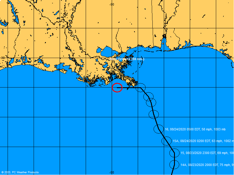
Using the past flight's recon fixes and the latest you can extrapolate landfall on google earth to around Port St. Lucie. That is 300 miles away so of course it will end up further up or down the coast.
0 likes

Re: ATL: MATTHEW - Hurricane - Discussion
Aric Dunn wrote:bahamaswx wrote:Also note that the pass shows no real sign of double wind maxima. No EWRC on the table right now.
again way to early for a ERC. the core just got established .. highly doubt we will see a ERC before landfall. should strengthen/maintain all the way to land.
Not good!
0 likes
-
Aric Dunn
- Category 5

- Posts: 21238
- Age: 43
- Joined: Sun Sep 19, 2004 9:58 pm
- Location: Ready for the Chase.
- Contact:
Re: ATL: MATTHEW - Hurricane - Discussion
another very intense burst of convection with the eyewall. should only help warm the core and deepen it.
1 likes
Note: If I make a post that is brief. Please refer back to previous posts for the analysis or reasoning. I do not re-write/qoute what my initial post said each time.
If there is nothing before... then just ask
Space & Atmospheric Physicist, Embry-Riddle Aeronautical University,
I believe the sky is falling...
If there is nothing before... then just ask
Space & Atmospheric Physicist, Embry-Riddle Aeronautical University,
I believe the sky is falling...
-
Aric Dunn
- Category 5
- Posts: 21238
- Age: 43
- Joined: Sun Sep 19, 2004 9:58 pm
- Location: Ready for the Chase.
- Contact:
Re: ATL: MATTHEW - Hurricane - Discussion
The NOAA plane must be a synoptic flight..
0 likes
Note: If I make a post that is brief. Please refer back to previous posts for the analysis or reasoning. I do not re-write/qoute what my initial post said each time.
If there is nothing before... then just ask
Space & Atmospheric Physicist, Embry-Riddle Aeronautical University,
I believe the sky is falling...
If there is nothing before... then just ask
Space & Atmospheric Physicist, Embry-Riddle Aeronautical University,
I believe the sky is falling...
Re: ATL: MATTHEW - Hurricane - Discussion
marionstorm wrote:Using the past flight's recon fixes and the latest you can extrapolate landfall on google earth to around Port St. Lucie. That is 300 miles away so of course it will end up further up or down the coast.
The Euro and GFS have done a very good job withing 24hr window. BTW, to be exact its fixed center is 277 miles from Port St Lucie
0 likes
-
tropicwatch

- Category 5
- Posts: 3426
- Age: 62
- Joined: Sat Jun 02, 2007 10:01 am
- Location: The Villages, Florida
- Contact:
Re: ATL: MATTHEW - Hurricane - Discussion
Wonder if NHC is waiting on a wind radii from hh.
0 likes
Tropicwatch
Agnes 72', Eloise 75, Elena 85', Kate 85', Charley 86', Florence 88', Beryl 94', Dean 95', Erin 95', Opal 95', Earl 98', Georges 98', Ivan 2004', Arlene 2005', Dennis 2005', Ida 2009' Debby 2012' Irma 2017' Michael 2018'
Agnes 72', Eloise 75, Elena 85', Kate 85', Charley 86', Florence 88', Beryl 94', Dean 95', Erin 95', Opal 95', Earl 98', Georges 98', Ivan 2004', Arlene 2005', Dennis 2005', Ida 2009' Debby 2012' Irma 2017' Michael 2018'
-
KBBOCA
- S2K Supporter

- Posts: 1559
- Joined: Fri Sep 05, 2003 5:27 am
- Location: Formerly Boca Raton, often West Africa. Currently Charlotte NC
Re: ATL: MATTHEW - Hurricane - Discussion
StrongWind wrote:Years ago I saw a graphic that dynamically showed the predicted wind field as the hurricane moved along the track. Is there something like this for Matthew?
From the BoatUS site, here is the windfield graphic:
And from Skeetobite, (http://www.skeetobiteweather.com/) a graphic which overlays the windfield on the track:

and

Last edited by KBBOCA on Thu Oct 06, 2016 3:59 am, edited 1 time in total.
1 likes
-
johngaltfla

- Category 5
- Posts: 2073
- Joined: Sun Jul 10, 2005 9:17 pm
- Location: Sarasota County, FL
- Contact:
Re: ATL: MATTHEW - Hurricane - Discussion
panamatropicwatch wrote:Wonder if NHC is waiting on a wind radii from hh.
This is pretty much the most critical update at 0500. It will cause a panic among those that thought they could ride it out which is not unusual down here as you know.
That eye is looking meaner by the minute and I fear what happens when it gets to the Gulf Stream.
2 likes
-
Aric Dunn
- Category 5
- Posts: 21238
- Age: 43
- Joined: Sun Sep 19, 2004 9:58 pm
- Location: Ready for the Chase.
- Contact:
Re: ATL: MATTHEW - Hurricane - Discussion
panamatropicwatch wrote:Wonder if NHC is waiting on a wind radii from hh.
up to 125mph..
8am might be looking at a high cat 4
0 likes
Note: If I make a post that is brief. Please refer back to previous posts for the analysis or reasoning. I do not re-write/qoute what my initial post said each time.
If there is nothing before... then just ask
Space & Atmospheric Physicist, Embry-Riddle Aeronautical University,
I believe the sky is falling...
If there is nothing before... then just ask
Space & Atmospheric Physicist, Embry-Riddle Aeronautical University,
I believe the sky is falling...
-
johngaltfla
- Category 5
- Posts: 2073
- Joined: Sun Jul 10, 2005 9:17 pm
- Location: Sarasota County, FL
- Contact:
Re: ATL: MATTHEW - Hurricane - Discussion
NDG wrote:Up to 110 knots on the 5 AM advisory.
Yup, 944 mb. Not good. This is a very bad sign as it is now in prime position to crank up well past 135 mph, IMHO before skirting the FL coastline.
0 likes
-
brunota2003

- S2K Supporter
- Posts: 9476
- Age: 35
- Joined: Sat Jul 30, 2005 9:56 pm
- Location: Stanton, KY...formerly Havelock, NC
- Contact:
Re: ATL: MATTHEW - Hurricane - Discussion
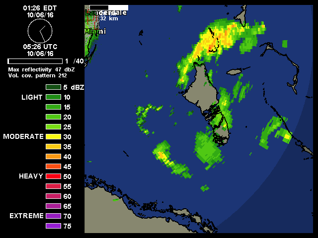
Looking at the Miami radar, does it look like the eye is heading on a more WNW heading? Hopefully it is just a wobble, or my tired eyes seeing things...
0 likes
Just a small town southern boy helping other humans.

-
SouthFloridawx

- S2K Supporter
- Posts: 8346
- Age: 47
- Joined: Tue Jul 26, 2005 1:16 am
- Location: Sarasota, FL
- Contact:
Re: RE: Re: ATL: MATTHEW - Hurricane - Discussion
NHC says NW so, I don't know.
brunota2003 wrote:Looking at the Miami radar, does it look like the eye is heading on a more WNW heading? Hopefully it is just a wobble, or my tired eyes seeing things...
1 likes
-
CourierPR

- Category 5
- Posts: 1336
- Age: 72
- Joined: Tue Aug 31, 2004 7:53 pm
- Location: Pompano Beach, Florida
Re: ATL: MATTHEW - Hurricane - Discussion
brunota2003 wrote:Looking at the Miami radar, does it look like the eye is heading on a more WNW heading? Hopefully it is just a wobble, or my tired eyes seeing things...
I was thinking the same thing and it has me nervous living in northern Broward County.
1 likes
-
jlauderdal
- S2K Supporter
- Posts: 7240
- Joined: Wed May 19, 2004 5:46 am
- Location: NE Fort Lauderdale
- Contact:
Re: ATL: MATTHEW - Hurricane - Discussion
brunota2003 wrote:Looking at the Miami radar, does it look like the eye is heading on a more WNW heading? Hopefully it is just a wobble, or my tired eyes seeing things...
doesnt look 320 to me now but its been averaging that over time and they must feel confident the ridge is about done building
anyone ever see them report higher than normal confidence in any disco ever for any time period..
there is lower than normal confidence in the days 4 and 5 track
prediction.
0 likes
-
tropicwatch
- Category 5
- Posts: 3426
- Age: 62
- Joined: Sat Jun 02, 2007 10:01 am
- Location: The Villages, Florida
- Contact:
Re: ATL: MATTHEW - Hurricane - Discussion
Still general nw motion.
http://weather.msfc.nasa.gov/cgi-bin/get-goes?satellite=GOES-E%20CONUS&lat=23&lon=-77&zoom=1&width=1000&height=800&quality=90&type=Animation&palette=ir2.pal&numframes=30&mapcolor=yellow&map=latlon
http://weather.msfc.nasa.gov/cgi-bin/get-goes?satellite=GOES-E%20CONUS&lat=23&lon=-77&zoom=1&width=1000&height=800&quality=90&type=Animation&palette=ir2.pal&numframes=30&mapcolor=yellow&map=latlon
0 likes
Tropicwatch
Agnes 72', Eloise 75, Elena 85', Kate 85', Charley 86', Florence 88', Beryl 94', Dean 95', Erin 95', Opal 95', Earl 98', Georges 98', Ivan 2004', Arlene 2005', Dennis 2005', Ida 2009' Debby 2012' Irma 2017' Michael 2018'
Agnes 72', Eloise 75, Elena 85', Kate 85', Charley 86', Florence 88', Beryl 94', Dean 95', Erin 95', Opal 95', Earl 98', Georges 98', Ivan 2004', Arlene 2005', Dennis 2005', Ida 2009' Debby 2012' Irma 2017' Michael 2018'
-
brunota2003
- S2K Supporter
- Posts: 9476
- Age: 35
- Joined: Sat Jul 30, 2005 9:56 pm
- Location: Stanton, KY...formerly Havelock, NC
- Contact:
Re: ATL: MATTHEW - Hurricane - Discussion
The next couple of Recon fixes will be interesting. It'll give us a longer term motion, that is better than eyes at 5 in the morning!
0 likes
Just a small town southern boy helping other humans.

Re: ATL: MATTHEW - Hurricane - Discussion
Matthew cranking now as DMAX approaches - pretty much as I indicated yesterday.
Eye suddenly popping on IR.
He entrained very moist, high-energy air as indicated by the high Theta-E and CAPE values in the Bahamas.
This on top of the high heat content of the water.

Eye suddenly popping on IR.
He entrained very moist, high-energy air as indicated by the high Theta-E and CAPE values in the Bahamas.
This on top of the high heat content of the water.
0 likes
Who is online
Users browsing this forum: No registered users and 19 guests