ATL: HERMINE - Post-Tropical - Discussion
Moderator: S2k Moderators
-
Aric Dunn
- Category 5

- Posts: 21238
- Age: 43
- Joined: Sun Sep 19, 2004 9:58 pm
- Location: Ready for the Chase.
- Contact:
Re: ATL: HERMINE - Hurricane - Discussion
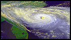
eye is shrinking pretty quickly.. convection building.. should get interesting..
1 likes
Note: If I make a post that is brief. Please refer back to previous posts for the analysis or reasoning. I do not re-write/qoute what my initial post said each time.
If there is nothing before... then just ask
Space & Atmospheric Physicist, Embry-Riddle Aeronautical University,
I believe the sky is falling...
If there is nothing before... then just ask
Space & Atmospheric Physicist, Embry-Riddle Aeronautical University,
I believe the sky is falling...
-
Aric Dunn
- Category 5
- Posts: 21238
- Age: 43
- Joined: Sun Sep 19, 2004 9:58 pm
- Location: Ready for the Chase.
- Contact:
Re: ATL: HERMINE - Hurricane - Discussion
NJWxHurricane wrote:Michele B wrote:johngaltfla wrote:If this is the only landfall for hurricanes in Florida, I'm good for this season.
Weird how the weather got nasty earlier with high winds, heavy rain and now it's super calm relative to yesterday and lunch time today.
Don't count it out yet. It looks like it's going more NE than NNE to me. I think another band of weather is still poised to come our way.
It's almost due north. It's not going NE anymore.
its still average of ne to NNE.. what your seeing is another inner core wobble soon it will look like it slowed and then will shift back east to ne as it completes the loops.
1 likes
Note: If I make a post that is brief. Please refer back to previous posts for the analysis or reasoning. I do not re-write/qoute what my initial post said each time.
If there is nothing before... then just ask
Space & Atmospheric Physicist, Embry-Riddle Aeronautical University,
I believe the sky is falling...
If there is nothing before... then just ask
Space & Atmospheric Physicist, Embry-Riddle Aeronautical University,
I believe the sky is falling...
Re: ATL: HERMINE - Hurricane - Discussion
I believe we will still be looking at 1 a.m. All these cyclonic loops are just negating the faster forward motion from earlier.
0 likes
Personal Forecast Disclaimer:
The posts in this forum are NOT official forecast and should not be used as such. They are just the opinion of the poster and may or may not be backed by sound meteorological data. They are NOT endorsed by any professional institution or storm2k.org. For official information, please refer to the NHC and NWS products.
The posts in this forum are NOT official forecast and should not be used as such. They are just the opinion of the poster and may or may not be backed by sound meteorological data. They are NOT endorsed by any professional institution or storm2k.org. For official information, please refer to the NHC and NWS products.
-
Hurricane Andrew

- S2K Supporter

- Posts: 1891
- Age: 27
- Joined: Sun May 23, 2010 2:53 pm
- Location: KS
Re: ATL: HERMINE - Hurricane - Discussion
Convection building on all sides of the eyewall, if this had an extra twelve hours we would be looking at a category two. As it is, I believe a strong category one is probably.
1 likes
The Enthusiast
NREMT-AEMT, WX nerd
Irene '11, Sandy '12, Irma '17 (SAR)
"Hard to think we were born to live this way..." -Wage War
Re: ATL: HERMINE - Hurricane - Discussion
Very strange...just about 5 miles from the coast in New Port Richey up in Pasco County...as there have been several on and off quick downbursts of precip however it has not brought down any of the stronger winds to the surface in these bands...just very heavy vertical downpours...then...poof...gone...back to warm, moldy, and stagnant. Even though this system has a massive wind field...I wonder if either the dry air entrained into the eastern side is weakening the convective transport of energy to the ground...or maybe we are just not going to get into the sustained wind field with the current quick motion....puzzling...
0 likes
-
jlauderdal
- S2K Supporter
- Posts: 7240
- Joined: Wed May 19, 2004 5:46 am
- Location: NE Fort Lauderdale
- Contact:
Re: ATL: HERMINE - Hurricane - Discussion
GCANE wrote:Cloud tops getting colder on the NW eyewall

ir looks decent but radar is telling a different story..looks like there is a drying trend the last hour or so...one hour doesnt make a storm though...cat 1 surge for sure...things have been active on the eastern side too
1 likes

Re: ATL: HERMINE - Hurricane - Discussion

This is ironically preventing rain in the middle part of Georgia--we're under high clouds and it's reflecting enough sunlight to keep the rain from forming, but there's a band north of here where the outflow clouds are thinner.
1 likes
The above post is not official and should not be used as such. It is the opinion of the poster and may or may not be backed by sound meteorological data. It is not endorsed by any professional institution or storm2k.org. For official information, please refer to the NHC and NWS products.
-
CrazyC83
- Professional-Met

- Posts: 34315
- Joined: Tue Mar 07, 2006 11:57 pm
- Location: Deep South, for the first time!
Re: ATL: HERMINE - Recon
000
URNT15 KWBC 012031
NOAA3 WXWXA HERMINE HDOB 09 20160901
202200 2931N 08443W 6958 03145 0020 +096 +088 128037 038 040 000 03
202230 2930N 08445W 6958 03148 0020 +096 +089 125036 037 /// /// 03
202300 2930N 08447W 6958 03143 0019 +095 +093 125036 036 /// /// 03
202330 2930N 08450W 6958 03142 0018 +093 //// 123036 037 /// /// 05
202400 2930N 08453W 6957 03142 0014 +097 +089 121035 036 /// /// 03
202430 2930N 08455W 6957 03142 0014 +097 +090 118034 035 /// /// 03
202500 2930N 08458W 6958 03142 0012 +099 +083 118034 034 /// /// 03
202530 2929N 08500W 6957 03138 0008 +100 +083 114033 034 /// /// 03
202600 2927N 08500W 6958 03135 0006 +098 +089 112034 035 /// /// 03
202630 2925N 08500W 6960 03127 0003 +094 +092 112036 037 /// /// 03
202700 2923N 08500W 6960 03124 0004 +091 +091 109034 034 036 001 00
202730 2921N 08500W 6957 03126 0005 +090 +088 109039 041 036 000 00
202800 2919N 08500W 6960 03118 9996 +094 +087 105039 040 037 000 00
202830 2917N 08500W 6958 03121 9996 +092 +084 103042 043 038 001 00
202900 2915N 08500W 6960 03111 9985 +098 +086 100043 045 039 001 00
202930 2913N 08500W 6946 03125 9969 +104 +094 097042 042 040 006 00
203000 2911N 08500W 6941 03129 9966 +103 +098 096040 041 042 011 00
203030 2909N 08500W 6963 03099 9963 +104 //// 096034 036 051 020 01
203100 2907N 08500W 6909 03157 9960 +096 //// 123053 059 050 035 01
203130 2905N 08500W 6875 03191 9936 +104 //// 134053 056 051 020 01
0 likes
Re: ATL: HERMINE - Hurricane - Discussion
TPAcane wrote:Very strange...just about 5 miles from the coast in New Port Richey up in Pasco County...as there have been several on and off quick downbursts of precip however it has not brought down any of the stronger winds to the surface in these bands...just very heavy vertical downpours...then...poof...gone...back to warm, moldy, and stagnant. Even though this system has a massive wind field...I wonder if either the dry air entrained into the eastern side is weakening the convective transport of energy to the ground...or maybe we are just not going to get into the sustained wind field with the current quick motion....puzzling...
The best chance will be tonight especially as the vector turns more onshore near the coast. even so it's no guarantee. tonight's convective evolution is key as that will help transport stronger winds to the surface. It's nowcasting time.
1 likes
Re: ATL: HERMINE - Hurricane - Discussion
24ft wave heights at this buoy: http://www.ndbc.noaa.gov/station_page.php?station=42099
0 likes
Personal Forecast Disclaimer:
The posts in this forum are NOT official forecast and should not be used as such. They are just the opinion of the poster and may or may not be backed by sound meteorological data. They are NOT endorsed by any professional institution or storm2k.org. For official information, please refer to the NHC and NWS products.
The posts in this forum are NOT official forecast and should not be used as such. They are just the opinion of the poster and may or may not be backed by sound meteorological data. They are NOT endorsed by any professional institution or storm2k.org. For official information, please refer to the NHC and NWS products.
-
NJWxHurricane
- Tropical Storm

- Posts: 145
- Joined: Wed Aug 24, 2016 11:51 am
- Location: Seaside Heights, NJ (Jersey Shore)
-
CrazyC83
- Professional-Met
- Posts: 34315
- Joined: Tue Mar 07, 2006 11:57 pm
- Location: Deep South, for the first time!
Re: ATL: HERMINE - Recon
000
URNT15 KWBC 012041
NOAA3 WXWXA HERMINE HDOB 10 20160901
203200 2903N 08500W 6958 03090 9931 +112 //// 127048 048 049 008 01
203230 2901N 08500W 6960 03082 9927 +114 //// 124047 048 048 006 05
203300 2859N 08502W 6953 03086 9917 +116 //// 123046 047 045 008 01
203330 2857N 08503W 6939 03098 9907 +118 //// 127047 051 042 008 01
203400 2856N 08504W 6949 03078 9894 +122 //// 124043 045 043 010 01
203430 2854N 08505W 6946 03075 9880 +127 //// 127038 041 047 007 01
203500 2852N 08506W 6946 03071 9875 +129 //// 122034 035 047 007 01
203530 2850N 08507W 6953 03057 9862 +135 +133 118030 034 049 007 00
203600 2848N 08509W 6953 03055 9858 +139 +118 117025 026 043 002 00
203630 2847N 08510W 6952 03052 9852 +142 +107 112021 022 029 000 00
203700 2845N 08511W 6955 03048 9853 +138 +122 110016 018 021 000 00
203730 2843N 08511W 6952 03049 9847 +140 +124 102008 010 019 000 00
203800 2840N 08512W 6958 03043 9844 +146 +105 085006 007 018 000 03
203830 2838N 08511W 6952 03046 9840 +149 +096 069004 005 018 000 03
203900 2837N 08510W 6953 03045 9835 +154 +086 030000 002 020 000 03
203930 2835N 08510W 6953 03047 9836 +154 +078 293003 003 020 000 03
204000 2832N 08510W 6958 03042 9845 +146 +084 268004 006 025 000 00
204030 2830N 08510W 6954 03044 9845 +145 +081 259006 007 026 000 00
204100 2828N 08510W 6956 03043 9844 +147 +079 273008 009 021 000 00
204130 2826N 08510W 6957 03043 9845 +147 +080 272009 010 023 000 00
Pressure 984mb.
0 likes
-
Aric Dunn
- Category 5
- Posts: 21238
- Age: 43
- Joined: Sun Sep 19, 2004 9:58 pm
- Location: Ready for the Chase.
- Contact:
Re: ATL: HERMINE - Hurricane - Discussion
983.. not surprised at all with how much the eye has been shrinking and convection building.. that a significant drop for an hour..
1 likes
Note: If I make a post that is brief. Please refer back to previous posts for the analysis or reasoning. I do not re-write/qoute what my initial post said each time.
If there is nothing before... then just ask
Space & Atmospheric Physicist, Embry-Riddle Aeronautical University,
I believe the sky is falling...
If there is nothing before... then just ask
Space & Atmospheric Physicist, Embry-Riddle Aeronautical University,
I believe the sky is falling...
-
OntarioEggplant
- Category 1

- Posts: 312
- Joined: Sun Aug 07, 2016 11:16 am

Re: ATL: HERMINE - Hurricane - Discussion
OntarioEggplant wrote:So the pressure appears to have dropped some
It's dropped drastically in an hour.
Thankfully it doesn't have much time left to bomb (assuming this is a sign of things to come).
0 likes
-
cycloneye

- Admin

- Posts: 149540
- Age: 69
- Joined: Thu Oct 10, 2002 10:54 am
- Location: San Juan, Puerto Rico
Re: ATL: HERMINE - Advisories
BULLETIN
HURRICANE HERMINE ADVISORY NUMBER 18
NWS NATIONAL HURRICANE CENTER MIAMI FL AL092016
400 PM CDT THU SEP 01 2016
...HURRICANE HERMINE HEADED FOR THE NORTHEAST GULF COAST...
...LIFE-THREATENING SURGE AND FLOODING RAINS EXPECTED...
SUMMARY OF 400 PM CDT...2100 UTC...INFORMATION
----------------------------------------------
LOCATION...28.5N 85.0W
ABOUT 85 MI...135 KM S OF APALACHICOLA FLORIDA
ABOUT 120 MI...195 KM WSW OF CEDAR KEY FLORIDA
MAXIMUM SUSTAINED WINDS...75 MPH...120 KM/H
PRESENT MOVEMENT...NNE OR 30 DEGREES AT 14 MPH...22 KM/H
MINIMUM CENTRAL PRESSURE...988 MB...29.18 INCHES
WATCHES AND WARNINGS
--------------------
CHANGES WITH THIS ADVISORY:
The Tropical Storm Warning has been extended northward along the
United States Atlantic coast north of Surf City to Duck, North
Carolina, including the Pamlico and Albemarle Sounds.
A Tropical Storm Watch has been issued north of Duck to Sandy Hook,
New Jersey, including the Chesapeake Bay from Smith Point southward,
and the southern Delaware Bay.
SUMMARY OF WATCHES AND WARNINGS IN EFFECT:
A Hurricane Warning is in effect for...
* Suwannee River to Mexico Beach
A Hurricane Watch is in effect for...
* Anclote River to Suwannee River
* West of Mexico Beach to the Walton/Bay County line
A Tropical Storm Warning is in effect for...
* Englewood to Suwannee River
* West of Mexico Beach to the Walton/Bay County line
* Flagler/Volusia County line to Duck
* Pamlico and Albemarle Sounds
A Tropical Storm Watch is in effect for...
* North of Duck to Sandy Hook
* Chesapeake Bay from Smith Point southward
* Southern Delaware Bay
Interests elsewhere along the United States northeast coast should
monitor the progress of this system.
HURRICANE HERMINE DISCUSSION NUMBER 18
NWS NATIONAL HURRICANE CENTER MIAMI FL AL092016
400 PM CDT THU SEP 01 2016
Hermine was recently upgraded to a hurricane based on an
SFMR-observed surface wind from an Air Force Hurricane Hunter
aircraft. The initial intensity is set at 65 kt based on that
observation. Satellite images show that the cloud pattern continues
to gradually become better organized with more distinct curved bands
of showers and thunderstorms, although the system currently lacks
concentrated inner-core convection. Hermine has a little more time
to strengthen, so the official forecast shows a slight additional
increase in intensity before landfall. This is consistent with the
latest LGEM guidance. Hermine is forecast to become extratropical
at 48 hours when the global models forecast it to become embedded
within a frontal zone. Later in the forecast period,
vertical shear decreases and the cyclone could be situated over
marginally warm waters. Therefore there is the possibility of the
system regaining some tropical characteristics in 4-5 days, although
this is speculative at this time.
Aircraft center fixes indicate that the motion remains 030/12 kt.
The flow on the eastern side of a mid-level trough over the
southeastern United States should cause Hermine to move
north-northeastward to northeastward with some increase in forward
speed during the next day so. By 48 hours, the track guidance
shows the system slowing down as it begins to interact with a
mid-level cutoff vortex over the eastern United States. In 3 days
or so, the post-tropical cyclone merges with the cutoff low and a
further slowing down of the motion is expected. The official track
forecast lies between the latest GFS and ECMWF predictions.
KEY MESSAGES:
1. As landfall nears, it is important to not focus on the exact
forecast track. Hermine is an extremely asymmetric storm, with a
large extent of dangerous winds, life-threatening storm surge, and
flooding rains well to the east and southeast of the path of the
center.
2. Hermine is expected to become a post-tropical cyclone while still
producing hazardous winds and storm surge over land. NWS policy
allows NHC to write advisories on and issue tropical storm
watches and warnings for post-tropical cyclones, when the system
continues to pose a significant threat to life and property.
NHC and the NWS Eastern Region have decided that this option will be
invoked for Hermine. After Hermine becomes a post-tropical cyclone,
NHC will continue to issue its full suite of advisory and warning
products for as long as the system remains a significant threat to
land.
FORECAST POSITIONS AND MAX WINDS
INIT 01/2100Z 28.5N 85.0W 65 KT 75 MPH
12H 02/0600Z 30.2N 83.9W 70 KT 80 MPH
24H 02/1800Z 32.4N 81.6W 50 KT 60 MPH...INLAND
36H 03/0600Z 34.5N 78.2W 45 KT 50 MPH...INLAND
48H 03/1800Z 36.3N 75.0W 45 KT 50 MPH...POST-TROP/EXTRATROP
72H 04/1800Z 38.0N 72.5W 50 KT 60 MPH...POST-TROP/EXTRATROP
96H 05/1800Z 38.5N 71.5W 50 KT 60 MPH...POST-TROP/EXTRATROP
120H 06/1800Z 39.5N 70.5W 45 KT 50 MPH...POST-TROP/EXTRATROP
$$
Forecaster Pasch
0 likes
Visit the Caribbean-Central America Weather Thread where you can find at first post web cams,radars
and observations from Caribbean basin members Click Here
and observations from Caribbean basin members Click Here

Re: ATL: HERMINE - Hurricane - Discussion
TPAcane wrote:Very strange...just about 5 miles from the coast in New Port Richey up in Pasco County...as there have been several on and off quick downbursts of precip however it has not brought down any of the stronger winds to the surface in these bands...just very heavy vertical downpours...then...poof...gone...back to warm, moldy, and stagnant. Even though this system has a massive wind field...I wonder if either the dry air entrained into the eastern side is weakening the convective transport of energy to the ground...or maybe we are just not going to get into the sustained wind field with the current quick motion....puzzling...
One more band of thunderstorms coming through before sunset then things should quiet down some like they did last night.
Those storms are moving at about 45 knots N over the entire county of Pinellas before reaching you up in Pasco. Most of the power outages have been south county down in St Petersburg (so far).
2 likes
Re: ATL: HERMINE - Hurricane - Discussion
Since it they measured 20 sfmr, couldn't it potentially be even a little lower?
Aric Dunn wrote:983.. not surprised at all with how much the eye has been shrinking and convection building.. that a significant drop for an hour..
0 likes
-
Aric Dunn
- Category 5
- Posts: 21238
- Age: 43
- Joined: Sun Sep 19, 2004 9:58 pm
- Location: Ready for the Chase.
- Contact:
Re: ATL: HERMINE - Hurricane - Discussion
artist wrote:Since it they measured 20 sfmr, couldn't it potentially be even a little lower?Aric Dunn wrote:983.. not surprised at all with how much the eye has been shrinking and convection building.. that a significant drop for an hour..
yeah could be, the flight lvl center are a tad off so FL center was very low. surface winds were higher..
1 likes
Note: If I make a post that is brief. Please refer back to previous posts for the analysis or reasoning. I do not re-write/qoute what my initial post said each time.
If there is nothing before... then just ask
Space & Atmospheric Physicist, Embry-Riddle Aeronautical University,
I believe the sky is falling...
If there is nothing before... then just ask
Space & Atmospheric Physicist, Embry-Riddle Aeronautical University,
I believe the sky is falling...
Who is online
Users browsing this forum: No registered users and 91 guests