ATL: IRMA - Post-Tropical - Discussion
Moderator: S2k Moderators
-
KBBOCA
- S2K Supporter

- Posts: 1559
- Joined: Fri Sep 05, 2003 5:27 am
- Location: Formerly Boca Raton, often West Africa. Currently Charlotte NC
Re: ATL: IRMA - Hurricane - Discussion
That HRRR loop I just posted.... Wow. Entire east coast of FL gets the dirty side of the storm. Serious bands. And plus the storm surge in SW FL. Terrible...
Last edited by KBBOCA on Sun Sep 10, 2017 9:49 am, edited 1 time in total.
0 likes
-
CaptinCrunch

- S2K Supporter
- Posts: 8778
- Age: 58
- Joined: Mon Nov 03, 2003 4:33 pm
- Location: Kennedale, TX (Tarrant Co.)
Re: ATL: IRMA - Hurricane - Discussion
Reporter with wind meter in Miami Beach has 80 mph gust, that would translate to 110-120 mph winds 40 stories up. So yes that can damage those cranes, even in spin mode.
0 likes

Re: ATL: IRMA - Hurricane - Discussion
I did an extrap on radar based on the last 4 hours of current heading and speed, approximate timing. It shows landfall not until 4:00-4:30 PM this afternoon near Naples if it does not speed up or change heading. Keep in mind that the map below is not oriented S-N, but more like SSE-NNW tilt.

Last edited by NDG on Sun Sep 10, 2017 9:50 am, edited 1 time in total.
2 likes

Re: ATL: IRMA - Hurricane - Discussion
11:00 AM EDT Sun Sep 10
Location: 25.0°N 81.5°W
Moving: N at 9 mph
Min pressure: 933 mb
Max sustained: 130 mph
Location: 25.0°N 81.5°W
Moving: N at 9 mph
Min pressure: 933 mb
Max sustained: 130 mph
1 likes
-
AdamFirst

- S2K Supporter
- Posts: 2490
- Age: 36
- Joined: Thu Aug 14, 2008 10:54 am
- Location: Port Saint Lucie, FL
Re: ATL: IRMA - Hurricane - Discussion
1 likes
Dolphins Marlins Canes Golden Panthers HEAT
Andrew 1992 - Irene 1999 - Frances 2004 - Jeanne 2004 - Wilma 2005 - Fay 2008 - Isaac 2012 - Matthew 2016 - Irma 2017 - Dorian 2019 - Ian 2022 - Nicole 2022 - Milton 2024
Andrew 1992 - Irene 1999 - Frances 2004 - Jeanne 2004 - Wilma 2005 - Fay 2008 - Isaac 2012 - Matthew 2016 - Irma 2017 - Dorian 2019 - Ian 2022 - Nicole 2022 - Milton 2024
-
Rail Dawg
- S2K Supporter
- Posts: 326
- Joined: Mon Aug 27, 2012 5:02 pm
- Location: Where the eye makes landfall.
Re: ATL: IRMA - Hurricane - Discussion
Ya'll remember Buys Ballot's Law from weather school right?
Put your back to the wind stick your left arm out that is where the eye is.
Judging from this here in Naples I'm starting to think direct hit.
Yeah I know there's those satellite thingys too lol.
Put your back to the wind stick your left arm out that is where the eye is.
Judging from this here in Naples I'm starting to think direct hit.
Yeah I know there's those satellite thingys too lol.
5 likes
Although I have been a hurricane forecaster since 1980 that only means I've been wrong lots of times.
Re: ATL: IRMA - Hurricane - Discussion
CaptinCrunch wrote:Reporter with wind meter in Miami Beach has 80 mph gust, that would translate to 110-120 mph winds 40 stories up. So yes that can damage those cranes, even in spin mode.
That building appeared to be about 15 stories...
0 likes

Re: ATL: IRMA - Hurricane - Discussion
The center of Irma wobbled more northward over the past few hours
and the initial motion estimate is about 350/8 kt. Irma is embedded
within a broad mid-level gyre over the Gulf of Mexico. The cyclone
is expected to be steered north-northwestward at a faster forward
speed over the next day or two on the eastern side of the gyre. This
will take Irma inland over northern Florida early on Monday and the
southeastern United States over the next couple of days. The track
guidance remains fairly tightly clustered with the ECMWF track a
little to the left and slower than the other models. The official
track forecast lies between the model consensus and the ECMWF
solution. This is just slightly east of the previous official
forecast.
from 11 AM discussion..
SAY WHAT???
2 likes
Just like Jon Snow..."I know nothing" except what I know, and most of what I know is gathered by the fine people of the NHC
Re: ATL: IRMA - Hurricane - Discussion
Hurricane Irma Discussion Number 46
NWS National Hurricane Center Miami FL AL112017
1100 AM EDT Sun Sep 10 2017
Latest observations from the Air Force Hurricane Hunters had
flight-level winds that corresponded to surface winds near 110 kt.
Thus, given sampling considerations, the 115-kt intensity is
retained for this advisory. Irma should maintain this intensity
until the center reaches the southwest Florida coast, and then begin
to weaken while the system interacts with the landmass of the
Florida peninsula. Increasing southwesterly shear associated with
an upper-level trough should also cause weakening of the hurricane
during the next day or so. More rapid weakening is likely after Irma
moves into the southeastern United States in 24-36 hours, and the
cyclone should weaken to a remnant low in 72 hours or sooner. The
official intensity forecast is close to the simple and corrected
consensus models.
The center of Irma wobbled more northward over the past few hours
and the initial motion estimate is about 350/8 kt. Irma is embedded
within a broad mid-level gyre over the Gulf of Mexico. The cyclone
is expected to be steered north-northwestward at a faster forward
speed over the next day or two on the eastern side of the gyre. This
will take Irma inland over northern Florida early on Monday and the
southeastern United States over the next couple of days. The track
guidance remains fairly tightly clustered with the ECMWF track a
little to the left and slower than the other models. The official
track forecast lies between the model consensus and the ECMWF
solution. This is just slightly east of the previous official
forecast.
FORECAST POSITIONS AND MAX WINDS
INIT 10/1500Z 25.0N 81.5W 115 KT 130 MPH
12H 11/0000Z 26.6N 82.1W 110 KT 125 MPH
24H 11/1200Z 29.2N 83.0W 80 KT 90 MPH
36H 12/0000Z 31.9N 84.6W 40 KT 45 MPH...INLAND
48H 12/1200Z 33.8N 86.7W 30 KT 35 MPH...INLAND
72H 13/1200Z 36.0N 89.0W 25 KT 30 MPH...POST-TROP/INLAND
96H 14/1200Z 38.5N 86.5W 20 KT 25 MPH...POST-TROP/INLAND
120H 15/1200Z...DISSIPATED
1 likes
-
galaxy401

- Category 5

- Posts: 2446
- Age: 30
- Joined: Sat Aug 25, 2012 9:04 pm
- Location: Casa Grande, Arizona
Re: ATL: IRMA - Hurricane - Discussion
No mention of the dropsonde anywhere. Must of been unreliable.
0 likes
Got my eyes on moving right into Hurricane Alley: Florida.
-
PandaCitrus
- Category 1

- Posts: 424
- Joined: Mon Sep 04, 2017 2:44 pm
-
tolakram
- Admin

- Posts: 20179
- Age: 62
- Joined: Sun Aug 27, 2006 8:23 pm
- Location: Florence, KY (name is Mark)
Re: ATL: IRMA - Hurricane - Discussion
NHC does produce wind charts, as well as track graphics. You can't put everything on a single chart. 
http://www.nhc.noaa.gov/refresh/graphics_at1+shtml/093910.shtml?50wind120#wcontents
wait, actually you can with there new interactive chart. Forecast error cone is as important as wind speed area IMO.
http://www.nhc.noaa.gov/refresh/graphics_at1+shtml/093910.shtml?gm_track#contents
http://www.nhc.noaa.gov/refresh/graphics_at1+shtml/093910.shtml?50wind120#wcontents
wait, actually you can with there new interactive chart. Forecast error cone is as important as wind speed area IMO.
http://www.nhc.noaa.gov/refresh/graphics_at1+shtml/093910.shtml?gm_track#contents
1 likes
M a r k
- - - - -
Join us in chat: Storm2K Chatroom Invite. Android and IOS apps also available.
The posts in this forum are NOT official forecasts and should not be used as such. Posts are NOT endorsed by any professional institution or STORM2K.org. For official information and forecasts, please refer to NHC and NWS products.
-
tolakram
- Admin
- Posts: 20179
- Age: 62
- Joined: Sun Aug 27, 2006 8:23 pm
- Location: Florence, KY (name is Mark)
Re: ATL: IRMA - Hurricane - Discussion
I added some iPhone and Android app links to the chat instructions, for those of you who would like to join chat on a mobile device. Please be aware of data usage and battery life considerations if you don't have power!
http://www.storm2k.org/phpbb2/viewtopic.php?f=22&t=111692
http://www.storm2k.org/phpbb2/viewtopic.php?f=22&t=111692
2 likes
M a r k
- - - - -
Join us in chat: Storm2K Chatroom Invite. Android and IOS apps also available.
The posts in this forum are NOT official forecasts and should not be used as such. Posts are NOT endorsed by any professional institution or STORM2K.org. For official information and forecasts, please refer to NHC and NWS products.
- - - - -
Join us in chat: Storm2K Chatroom Invite. Android and IOS apps also available.
The posts in this forum are NOT official forecasts and should not be used as such. Posts are NOT endorsed by any professional institution or STORM2K.org. For official information and forecasts, please refer to NHC and NWS products.
-
Portaransas
- Tropical Low

- Posts: 21
- Joined: Wed Aug 23, 2017 3:16 pm
Re: ATL: IRMA - Hurricane - Discussion
Jeff Piotrowski looks to be set up very close to the where eye will land (again). Should be some great footage https://www.periscope.tv/Jeff_Piotrowski/1MnGnmNQrAyKO?
2 likes

-
Sciencerocks
- Category 5
- Posts: 10181
- Age: 40
- Joined: Thu Jul 06, 2017 1:51 am
Re: ATL: IRMA - Main Recon Thread (Data only)
000
URNT15 KNHC 101502
AF306 3011A IRMA HDOB 34 20170910
145300 2429N 08101W 6963 02940 9781 +119 +119 216082 085 063 007 00
145330 2430N 08102W 6966 02929 9778 +118 //// 216079 081 063 008 01
145400 2432N 08104W 6967 02922 9769 +121 +121 213074 078 059 006 00
145430 2433N 08105W 6969 02915 9759 +119 //// 213073 075 058 006 01
145500 2434N 08106W 6967 02911 9742 +120 +117 211073 074 058 005 00
145530 2436N 08108W 6967 02903 9734 +123 +114 211074 074 059 003 00
145600 2437N 08109W 6967 02896 9725 +122 +113 213075 076 074 008 03
145630 2438N 08111W 6967 02887 9713 +125 +113 214078 079 061 003 00
145700 2440N 08112W 6967 02880 9707 +124 +121 215081 082 061 005 00
145730 2441N 08114W 6969 02867 9693 +127 +105 215080 081 063 004 00
145800 2442N 08115W 6970 02857 9688 +122 +104 214083 084 059 002 00
145830 2443N 08116W 6967 02849 9676 +122 +104 214087 088 058 006 00
145900 2445N 08118W 6964 02840 9657 +124 +101 213089 090 077 009 00
145930 2446N 08119W 6965 02817 9636 +126 +112 212089 090 078 010 03
150000 2447N 08121W 6978 02788 9614 +128 +121 220092 093 065 008 00
150030 2448N 08122W 6961 02785 9590 +129 +114 224096 099 067 008 00
150100 2450N 08123W 6957 02765 9561 +134 +133 225097 099 076 009 00
150130 2451N 08124W 6975 02724 9531 +137 +137 225095 098 077 006 00
150200 2452N 08126W 6967 02705 9497 +142 +140 229099 100 082 006 00
150230 2453N 08127W 6974 02667 9459 +149 +135 234098 100 080 004 00
0 likes
-
KBBOCA
- S2K Supporter
- Posts: 1559
- Joined: Fri Sep 05, 2003 5:27 am
- Location: Formerly Boca Raton, often West Africa. Currently Charlotte NC
Re: ATL: IRMA - Hurricane - Discussion
15 different flood warnings for NWS Tampa Bay area just hit my Twitter feed...
0 likes
-
StormingB81

- S2K Supporter
- Posts: 5676
- Age: 44
- Joined: Thu Aug 27, 2009 1:45 am
- Location: Rockledge, Florida
Re: ATL: IRMA - Hurricane - Discussion
MrJames wrote:
They going to stick with it..probably just saw it was still in the cone if it doesnt get back on track ...
0 likes
-
tolakram
- Admin
- Posts: 20179
- Age: 62
- Joined: Sun Aug 27, 2006 8:23 pm
- Location: Florence, KY (name is Mark)
Re: ATL: IRMA - Hurricane - Discussion
https://twitter.com/RLuettich/status/906896240205582336
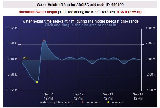
Rick Luettich @RLuettich
The maximum storm surge + waves in Naples will be ~ 2-3 hrs after eye. Combination can be devastating. #Irma
11:04 AM - Sep 10, 2017
Rick Luettich @RLuettich
The maximum storm surge + waves in Naples will be ~ 2-3 hrs after eye. Combination can be devastating. #Irma
11:04 AM - Sep 10, 2017
0 likes
M a r k
- - - - -
Join us in chat: Storm2K Chatroom Invite. Android and IOS apps also available.
The posts in this forum are NOT official forecasts and should not be used as such. Posts are NOT endorsed by any professional institution or STORM2K.org. For official information and forecasts, please refer to NHC and NWS products.
- - - - -
Join us in chat: Storm2K Chatroom Invite. Android and IOS apps also available.
The posts in this forum are NOT official forecasts and should not be used as such. Posts are NOT endorsed by any professional institution or STORM2K.org. For official information and forecasts, please refer to NHC and NWS products.
-
northjaxpro

- S2K Supporter
- Posts: 8900
- Joined: Mon Sep 27, 2010 11:21 am
- Location: Jacksonville, FL
Re: ATL: IRMA - Hurricane - Discussion
CronkPSU wrote:The center of Irma wobbled more northward over the past few hours
and the initial motion estimate is about 350/8 kt. Irma is embedded
within a broad mid-level gyre over the Gulf of Mexico. The cyclone
is expected to be steered north-northwestward at a faster forward
speed over the next day or two on the eastern side of the gyre. This
will take Irma inland over northern Florida early on Monday and the
southeastern United States over the next couple of days. The track
guidance remains fairly tightly clustered with the ECMWF track a
little to the left and slower than the other models. The official
track forecast lies between the model consensus and the ECMWF
solution. This is just slightly east of the previous official
forecast.
from 11 AM discussion..
SAY WHAT???
Well, NHC has responded with a slight adjustment east of thirvprevious official track. So, essentially, Irma's center will move a bit closer up the spine of the peninsula. Areas like Orlando, Ocala, and Gainesville will get a bit closer to Irma's center if this shift east continues.
Last edited by northjaxpro on Sun Sep 10, 2017 10:08 am, edited 1 time in total.
1 likes
NEVER, EVER SAY NEVER in the tropics and weather in general, and most importantly, with life itself!!
________________________________________________________________________________________
Fay 2008 Beryl 2012 Debby 2012 Colin 2016 Hermine 2016 Julia 2016 Matthew 2016 Irma 2017 Dorian 2019
________________________________________________________________________________________
Fay 2008 Beryl 2012 Debby 2012 Colin 2016 Hermine 2016 Julia 2016 Matthew 2016 Irma 2017 Dorian 2019
Who is online
Users browsing this forum: No registered users and 17 guests