
12z Euro is persistent in landfall near Naples, continuing on an almost due north heading.
Edit: Meant to type 12z GFS.
ATL: IRMA - Post-Tropical - Discussion
Moderator: S2k Moderators
Re: ATL: IRMA - Hurricane - Discussion
Last edited by NDG on Sun Sep 10, 2017 12:37 pm, edited 1 time in total.
1 likes
-
Sciencerocks
- Category 5

- Posts: 10181
- Age: 40
- Joined: Thu Jul 06, 2017 1:51 am
Re: ATL: IRMA - Main Recon Thread (Data only)
000
URNT15 KNHC 101532
AF306 3011A IRMA HDOB 37 20170910
152300 2549N 08226W 6967 03006 9888 +112 +112 068064 069 052 014 00
152330 2550N 08227W 6969 03008 9887 +111 +111 068060 061 052 012 03
152400 2552N 08229W 6968 03013 9880 +110 +110 064055 060 052 011 03
152430 2553N 08230W 6972 03008 9883 +112 +112 064054 055 053 010 00
152500 2554N 08232W 6970 03015 9881 +114 +114 062056 057 052 008 00
152530 2556N 08233W 6964 03026 9904 +110 //// 061056 057 055 010 05
152600 2557N 08235W 6967 03025 9909 +110 +110 062053 054 052 014 03
152630 2558N 08236W 6967 03030 9912 +108 +108 063055 056 051 014 03
152700 2600N 08238W 6965 03036 9903 +110 +110 063060 061 /// /// 03
152730 2601N 08239W 6967 03036 9903 +109 +109 066060 061 051 009 03
152800 2602N 08241W 6970 03036 9907 +107 +107 066060 061 050 008 03
152830 2604N 08242W 6965 03045 9910 +110 //// 073060 060 049 007 01
152900 2605N 08244W 6967 03045 9915 +107 //// 078064 067 049 006 01
152930 2607N 08245W 6960 03061 9946 +107 //// 076068 070 050 006 05
153000 2608N 08247W 6963 03057 9943 +110 +110 079063 066 048 013 03
153030 2609N 08249W 6974 03051 9935 +110 +110 072066 068 045 014 00
153100 2611N 08250W 6976 03048 9910 +117 +104 071059 062 043 006 03
153130 2612N 08252W 6966 03063 9918 +112 +104 073058 059 043 002 00
153200 2614N 08253W 6969 03061 9923 +114 +089 069052 056 042 002 00
153230 2615N 08255W 6968 03064 9928 +112 +078 068049 051 042 002 00
$$
0 likes


Re: ATL: IRMA - Hurricane - Discussion
GCANE wrote:

Slight turn more to the NNW. Naples looks like the next target. Maybe the straight northern movement is over.
2 likes
-
stormreader
Re: ATL: IRMA - Hurricane - Discussion
NDG wrote:12z Euro is persistent in landfall near Naples, continuing on an almost due north heading.
Going to be pretty rough in Naples.
0 likes
-
Portastorm

- Storm2k Moderator

- Posts: 9955
- Age: 63
- Joined: Fri Jul 11, 2003 9:16 am
- Location: Round Rock, TX
- Contact:
Re: ATL: IRMA - Hurricane - Discussion
KBBOCA wrote:wxman57 wrote:Just finished the Irma advisory. I think the NHC track is a good bit too far west. Center may move inland south of Naples this afternoon, barring any west wobble.
Any of you have a link to any live webcams that are still working? Anything from the chasers? Haven't had a chance to look around.
Mark Sudduth apparently has a stream going from Marco Island, but I'm not a subscriber / don't have link
If you follow him on Twitter at @JeffPiotrowski ... he has a live periscope going on now as he is driving around Marco Island.
1 likes
Any forecasts under my name are to be taken with a grain of salt. Get your best forecasts from the National Weather Service and National Hurricane Center.

Re: ATL: IRMA - Hurricane - Discussion
KBBOCA wrote:Tampa Bay waters being pushed out:
#Tampa Bay is being pushed out right now, as soon as those winds change that water is going to surge back in! #Irma
https://twitter.com/WeatherKait/status/906892683490287617
Reminds me of scenes in Thailand immediately before the Boxing Day Tsunami of 2004.
1 likes
-
jlauderdal
- S2K Supporter

- Posts: 7240
- Joined: Wed May 19, 2004 5:46 am
- Location: NE Fort Lauderdale
- Contact:
Re: RE: Re: ATL: IRMA - Hurricane - Discussion
Windier than ever in fllcaneseddy wrote:Seeing on WSVN right now Brickell Avenue is completely submerged although power is still on...water almost to the top of the steps in some of the high rises
0 likes
-
decgirl66

- S2K Supporter
- Posts: 292
- Age: 59
- Joined: Sun Aug 29, 2004 1:23 pm
- Location: Titusville, FL
Re: ATL: IRMA - Hurricane - Discussion
norva wrote:East Polk County here, just had a tornado warning, a squall line just came through. Getting windier...Power still on.
Thank you for posting! I'm in N Brevard, but my parents are in Winter Haven! Stay safe!
1 likes
-
KBBOCA
- S2K Supporter
- Posts: 1559
- Joined: Fri Sep 05, 2003 5:27 am
- Location: Formerly Boca Raton, often West Africa. Currently Charlotte NC
Re: ATL: IRMA - Hurricane - Discussion
Storm Surge threat NOT over for the Keys:
NWS Key WestVerified account @NWSKeyWest 10m10 minutes ago
Storm Surge remains a significant threat for the Keys. As the west winds continue storm surge could increase to 5-10 ft above ground level.
https://twitter.com/NWSKeyWest/status/9 ... 9749891073
NWS Key WestVerified account @NWSKeyWest 10m10 minutes ago
Storm Surge remains a significant threat for the Keys. As the west winds continue storm surge could increase to 5-10 ft above ground level.
https://twitter.com/NWSKeyWest/status/9 ... 9749891073
0 likes
-
otowntiger
- Category 5
- Posts: 1932
- Joined: Tue Aug 31, 2004 7:06 pm
Re: ATL: IRMA - Hurricane - Discussion
ConvergenceZone wrote:I think this will still be around 100mph by the time it reaches the Tampa area
It very well could be east of Tampa the way it's looking now. Which would be good for them.
0 likes
-
KBBOCA
- S2K Supporter
- Posts: 1559
- Joined: Fri Sep 05, 2003 5:27 am
- Location: Formerly Boca Raton, often West Africa. Currently Charlotte NC
Re: ATL: IRMA - Hurricane - Discussion
NWS Eastern RegionVerified account @NWSEastern 3m3 minutes ago
Here are some of the peak wind gust observations, observed rainfall, and forecast additional rainfall from #Irma as of 11 am EDT Sunday.
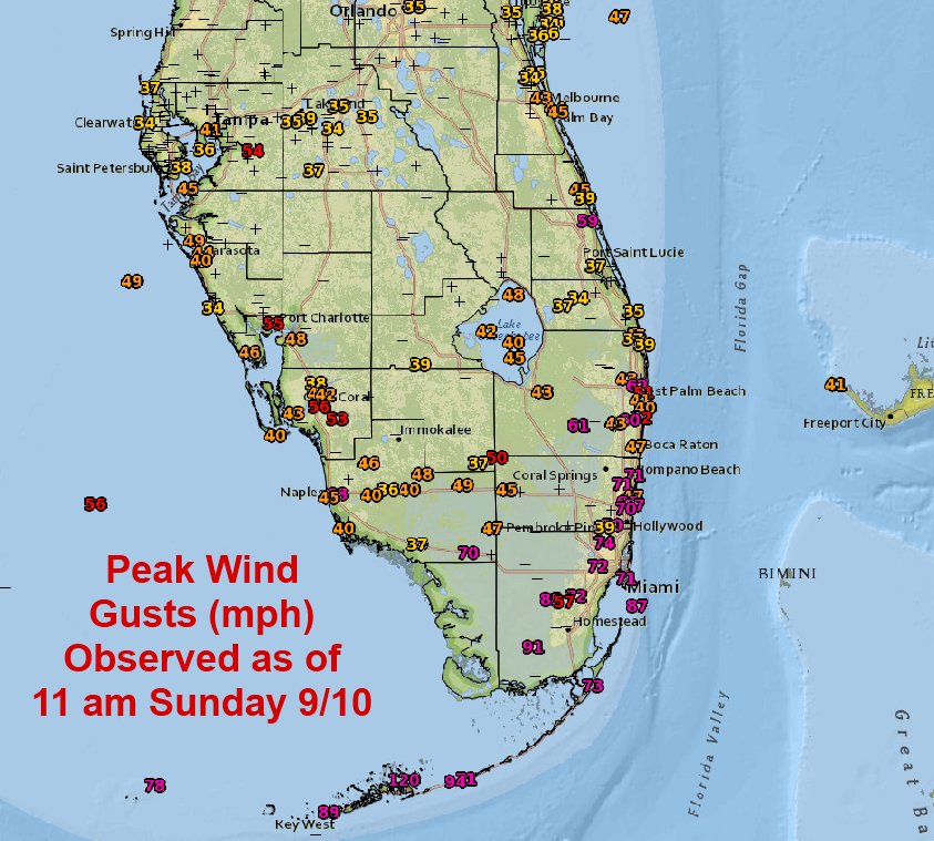
https://twitter.com/NWSEastern/status/906904708111060992
Here are some of the peak wind gust observations, observed rainfall, and forecast additional rainfall from #Irma as of 11 am EDT Sunday.
https://twitter.com/NWSEastern/status/906904708111060992
0 likes
-
CrazyC83
- Professional-Met

- Posts: 34315
- Joined: Tue Mar 07, 2006 11:57 pm
- Location: Deep South, for the first time!
Re: ATL: IRMA - Hurricane - Discussion
What was the validity of the 129 kt dropsonde report earlier? That seemed quite high. Drop that and I would probably go 110 kt for the current intensity.
0 likes
-
KBBOCA
- S2K Supporter
- Posts: 1559
- Joined: Fri Sep 05, 2003 5:27 am
- Location: Formerly Boca Raton, often West Africa. Currently Charlotte NC
Re: ATL: IRMA - Hurricane - Discussion
John MoralesVerified account @JohnMoralesNBC6 6m6 minutes ago
Rain: 4-8 inches in South Florida's metro area. Another foot possible. (note: locally higher amounts possible).
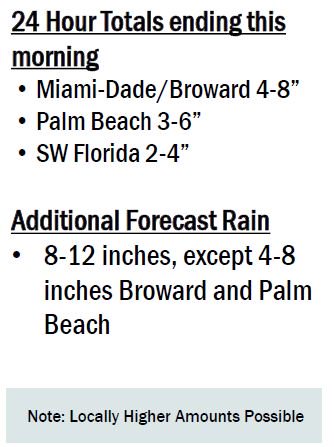
Rain: 4-8 inches in South Florida's metro area. Another foot possible. (note: locally higher amounts possible).
0 likes
-
Sciencerocks
- Category 5
- Posts: 10181
- Age: 40
- Joined: Thu Jul 06, 2017 1:51 am
Re: ATL: IRMA - Main Recon Thread (Data only)
000
URNT15 KNHC 101542
AF306 3011A IRMA HDOB 38 20170910
153300 2616N 08256W 6967 03068 9932 +112 +076 068050 050 042 003 00
153330 2618N 08258W 6964 03073 9934 +111 +076 070050 050 043 003 00
153400 2619N 08259W 6968 03069 9931 +115 +072 070050 051 043 001 00
153430 2620N 08301W 6967 03073 9940 +110 +077 074050 050 044 002 00
153500 2622N 08303W 6965 03078 9947 +105 +081 075049 049 044 002 00
153530 2623N 08304W 6967 03076 9950 +104 +084 075049 050 044 002 00
153600 2624N 08306W 6967 03080 9953 +105 +083 074051 052 045 001 00
153630 2626N 08307W 6970 03080 9955 +105 +086 072052 052 045 001 00
153700 2627N 08309W 6963 03089 9959 +103 +089 073052 053 044 002 03
153730 2628N 08310W 6973 03080 9958 +107 +086 072053 054 044 002 00
153800 2630N 08312W 6965 03094 9960 +106 +083 070052 054 043 003 00
153830 2631N 08314W 6970 03087 9971 +100 +088 070056 057 043 002 00
153900 2632N 08315W 6965 03095 //// +090 //// 071054 056 042 002 01
153930 2634N 08317W 6967 03095 //// +088 //// 072054 054 041 002 01
154000 2635N 08318W 6967 03097 //// +083 //// 068054 056 040 002 01
154030 2636N 08320W 6969 03097 0019 +092 //// 057056 058 039 005 05
154100 2638N 08321W 6966 03102 0022 +093 +093 055057 058 039 006 00
154130 2639N 08323W 6963 03107 0027 +092 //// 061058 061 041 007 01
154200 2640N 08324W 6972 03101 0035 +092 +092 054061 063 039 007 00
154230 2642N 08326W 6971 03103 0036 +088 //// 051052 060 041 008 05
$$
0 likes

Re: ATL: IRMA - Hurricane - Discussion
Melbourne FL here! We still have power. It’s a little windy and we have a ton of rain but I’m not sure how bad it’s supposed to get
2 likes
-
Bocadude85

- Category 5
- Posts: 2991
- Age: 39
- Joined: Mon Apr 18, 2005 2:20 pm
- Location: Honolulu,Hi
Re: ATL: IRMA - Hurricane - Discussion
Winds continue to increase here, we have had several power flashes but so far still have power.
2 likes
-
KBBOCA
- S2K Supporter
- Posts: 1559
- Joined: Fri Sep 05, 2003 5:27 am
- Location: Formerly Boca Raton, often West Africa. Currently Charlotte NC
Re: ATL: IRMA - Hurricane - Discussion
NWS OPCVerified account @NWSOPC 17m17 minutes ago
1512Z GOES16 (non-operational) visible satellite view of #Hurricane #Irma as it continues to impact #Florida.
https://twitter.com/NWSOPC/status/906902305441796097
1512Z GOES16 (non-operational) visible satellite view of #Hurricane #Irma as it continues to impact #Florida.
https://twitter.com/NWSOPC/status/906902305441796097
Last edited by KBBOCA on Sun Sep 10, 2017 10:49 am, edited 1 time in total.
0 likes

Re: ATL: IRMA - Hurricane - Discussion
Smiley face on GOES-16?

Slightly early frame...

Slightly early frame...
Last edited by birddogsc on Sun Sep 10, 2017 10:51 am, edited 1 time in total.
9 likes
-
HenkL
- S2K Supporter
- Posts: 2401
- Joined: Fri Sep 10, 2004 5:33 pm
- Location: Groningen, The Netherlands
- Contact:
Re: ATL: IRMA - Main Recon Thread (Data only)
URNT12 KNHC 101524
VORTEX DATA MESSAGE AL112017
A. 10/15:06:20Z
B. 25 deg 03 min N
081 deg 35 min W
C. 700 mb 2539 m
D. 82 kt
E. 139 deg 14 nm
F. 229 deg 100 kt
G. 139 deg 14 nm
H. 934 mb
I. 14 C / 3064 m
J. 19 C / 3048 m
K. 13 C / NA
L. OPEN S
M. NA
N. 12345 / 7
O. 0.02 / 2 nm
P. AF306 3011A IRMA OB 15
MAX FL WIND 100 KT 139 / 14 NM 15:02:00Z
CNTR DROPSONDE SFC WIND 230 / 9 KT
MAX FL TEMP 17 C 143 / 6 NM FROM FL CNTR
0 likes
-
stormreader
Re: ATL: IRMA - Hurricane - Discussion
Ok. Question for the many who really know how to look at the internal structure of the storm. To my untrained eye, it looks like Irma might be getting better organized here as it makes its run for the main Fl southwest coast. Storm stabilized at 130 and moved through the keys, is it possible that we are getting some late strengthening right now?
0 likes
Who is online
Users browsing this forum: No registered users and 111 guests