You are correct, sw carib too...the way things are going anywhere west of 60NDG wrote:jlauderdal wrote:Time to start looking at the gulf for future florida threatswxman57 wrote:Bad storm for the Caribbean, but it's looking more likely it won't be a threat to the East U.S. Coast. Chances of it passing within 125 miles of Florida down to 2-3%. Still about a 5% chance for the Outer Banks. Deep trof/front approaching the East Coast early next week should steer it northeastward. Time to head to the office to work on the next Maria advisory...
And NW Caribbean.
ATL: MARIA - Post-Tropical - Discussion
Moderator: S2k Moderators
-
jlauderdal
- S2K Supporter

- Posts: 7240
- Joined: Wed May 19, 2004 5:46 am
- Location: NE Fort Lauderdale
- Contact:
Re: RE: Re: RE: Re: ATL: MARIA - Hurricane - Discussion
0 likes

Re: ATL: MARIA - Hurricane - Discussion
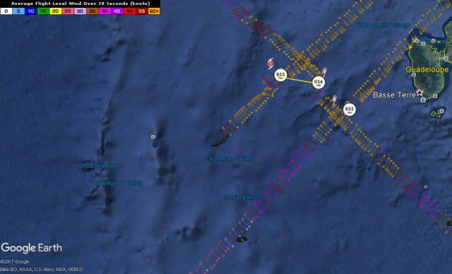
NE quadrant still remains strong, too bad there are no readings from SFMR.
115030 1615N 06235W 6963 02901 //// +080 //// 133117 120 /// /// 05
115100 1614N 06236W 6969 02857 //// +086 //// 131126 129 /// /// 05
115130 1613N 06237W 6967 02809 //// +102 //// 132136 140 /// /// 05
115200 1612N 06238W 6942 02779 //// +114 //// 140141 144 /// /// 05
115230 1611N 06240W 6985 02659 //// +131 //// 140128 137 /// /// 05
115300 1610N 06241W 6971 02608 9393 +150 +136 138091 117 /// /// 03
115330 1609N 06242W 6980 02547 9329 +168 +126 133052 081 /// /// 03
115400 1608N 06243W 6969 02550 9301 +184 +114 130013 037 /// /// 03
115430 1606N 06244W 6965 02562 9299 +198 +107 286017 020 /// /// 03
115500 1605N 06245W 6967 02586 9328 +193 +109 301027 032 /// /// 03
115530 1603N 06247W 6965 02618 9377 +172 +118 301045 052 /// /// 03
0 likes
-
SouthDadeFish

- Professional-Met

- Posts: 2835
- Joined: Thu Sep 23, 2010 2:54 pm
- Location: Miami, FL
- Contact:
Re: ATL: MARIA - Hurricane - Discussion
Very unfortunate the SFMR readings were not available. Looks like the extrapolated pressure dropped a couple millibars. I don't see any clear signs of a secondary eyewall from the flight-level winds either.
1 likes
-
SouthDadeFish
- Professional-Met
- Posts: 2835
- Joined: Thu Sep 23, 2010 2:54 pm
- Location: Miami, FL
- Contact:
Re: ATL: MARIA - Hurricane - Discussion
Maria is going to pass very near buoy station 42060. Latest wind gusts to 60 kt.
http://www.ndbc.noaa.gov/station_page.php?station=42060
http://www.ndbc.noaa.gov/station_page.php?station=42060
1 likes

Re: ATL: MARIA - Hurricane - Discussion
Eye still shrinking
Product: Air Force Vortex Message (URNT12 KNHC)
A. Time of Center Fix: 19th day of the month at 11:54:20Z
B. Center Fix Coordinates: 16°07'N 62°44'W (16.1167N 62.7333W)
F. Maximum Flight Level Wind Inbound: From 139° at 144kts (From the SE at ~ 165.7mph)
G. Location of Maximum Flight Level Wind Inbound: 8 nautical miles (9 statute miles) to the NE (43°) of center fix
H. Minimum Sea Level Pressure: 933mb (27.55 inHg)
I. Maximum Flight Level Temp & Pressure Altitude Outside Eye: 10°C (50°F) at a pressure alt. of 3,049m (10,003ft)
J. Maximum Flight Level Temp & Pressure Altitude Inside Eye: 20°C (68°F) at a pressure alt. of 3,058m (10,033ft)
K. Dewpoint Temp (collected at same location as temp inside eye): 11°C (52°F)
L. Eye Character: Closed
M. Eye Shape & Diameter: Circular with a diameter of 7 nautical miles
Remarks Section:
Maximum Flight Level Wind: 144kts (~ 165.7mph) which was observed 8 nautical miles to the NE (43°) from the flight level center at 11:52:00Z
Dropsonde Surface Wind at Center: From 145° at 25kts (From the SE at 29mph)
0 likes
-
SouthDadeFish
- Professional-Met
- Posts: 2835
- Joined: Thu Sep 23, 2010 2:54 pm
- Location: Miami, FL
- Contact:
Re: ATL: MARIA - Hurricane - Discussion
That eye dropsonde supports a pressure of 930-931 mb.
0 likes
-
AubreyStorm

- Category 1

- Posts: 337
- Age: 45
- Joined: Fri Jun 16, 2017 6:21 pm
- Location: Texas, USA
Re: ATL: MARIA - Hurricane - Discussion
Hmmmmmm? The ridge is strengthening to the north?
http://tropic.ssec.wisc.edu/real-time/m ... anim=html5
http://tropic.ssec.wisc.edu/real-time/m ... anim=html5
0 likes
The posts are NOT an official forecast. Please REFER to the NHC and NWS for official forecasts and products.

-
AubreyStorm
- Category 1
- Posts: 337
- Age: 45
- Joined: Fri Jun 16, 2017 6:21 pm
- Location: Texas, USA
Re: ATL: MARIA - Hurricane - Discussion
Not good!
0 likes
The posts are NOT an official forecast. Please REFER to the NHC and NWS for official forecasts and products.
-
euro6208
Re: ATL: MARIA - Hurricane - Discussion
I wonder just how strong our typhoons were. ADT, dvorak, and SATCON still below what recon is finding.
115 from dvorak, 135 from SATCON, and 130 from ADT. Some would say it is only a small margin but it is big when it is headed towards a populated area. Cat 4 or Cat 5.
Recon is truly essential. Our typhoons underestimated big time.
115 from dvorak, 135 from SATCON, and 130 from ADT. Some would say it is only a small margin but it is big when it is headed towards a populated area. Cat 4 or Cat 5.
Recon is truly essential. Our typhoons underestimated big time.
2 likes
-
Aric Dunn
- Category 5

- Posts: 21238
- Age: 43
- Joined: Sun Sep 19, 2004 9:58 pm
- Location: Ready for the Chase.
- Contact:
Re: ATL: MARIA - Hurricane - Discussion
THis could seriously be pumping up the ridging.. we need those GIV flights.
0 likes
Note: If I make a post that is brief. Please refer back to previous posts for the analysis or reasoning. I do not re-write/qoute what my initial post said each time.
If there is nothing before... then just ask
Space & Atmospheric Physicist, Embry-Riddle Aeronautical University,
I believe the sky is falling...
If there is nothing before... then just ask
Space & Atmospheric Physicist, Embry-Riddle Aeronautical University,
I believe the sky is falling...


Re: ATL: MARIA - Hurricane - Discussion
Gustywind wrote:Winds are really picking up in Guadeloupe! I cannot see anything from my house but i can assume you that i have this powerfull voice of the Wind behing my Windows..." Vrrr"... maybe strong gusts near 90-100 km/h IMO
Even Barbados had very squally weather in many parts last night. (A flood warning remains in effect until Noon, and all public schools have been ordered closed for a second day.) So, I can only imagine what you've been experiencing. Hope you're okay. Continue to keep us posted as best as you can.
4 likes
-
Dave C
- S2K Supporter
- Posts: 868
- Joined: Thu Sep 04, 2003 4:36 pm
- Location: Middleboro, Mass.(midway between Cape Cod and Boston)
Re: ATL: MARIA - Hurricane - Discussion
I hope everyone in ST Croix is prepared by now, it seems that the hurr. centers arrival time of the core may be later then what I see on sat. They have the core there around midnite but appears maybe comes in more towards sundown?
0 likes
Re: ATL: MARIA - Hurricane - Discussion
Weather will be going downhill during the day today across the VI Islands and P.R.
Just a few hours left before making final preparations. I hope everyone is sheltered well, do not stay in a wooden roof home, go to a re-enforced solid concrete building to ride out the hurricane, stay away from windows.

Just a few hours left before making final preparations. I hope everyone is sheltered well, do not stay in a wooden roof home, go to a re-enforced solid concrete building to ride out the hurricane, stay away from windows.
3 likes
-
arizona_sooner
- Tropical Depression

- Posts: 64
- Joined: Sat Jan 09, 2010 10:09 am
- Location: Peoria, AZ
Re: ATL: MARIA - Hurricane - Discussion
I was speaking with my fiance down in Trinidad last night on the phone and she said she saw lightning off in the distance all evening long. Probably 500 miles from the center of the storm, maybe related, maybe not.
1 likes
-
wxman57

- Moderator-Pro Met

- Posts: 23173
- Age: 68
- Joined: Sat Jun 21, 2003 8:06 pm
- Location: Houston, TX (southwest)
Re: ATL: MARIA - Hurricane - Discussion
arizona_sooner wrote:I was speaking with my fiance down in Trinidad last night on the phone and she said she saw lightning off in the distance all evening long. Probably 500 miles from the center of the storm, maybe related, maybe not.
Maria's eastern feeder band extends all the way down to Trinidad.
5 likes
-
dukeblue219
- S2K Supporter
- Posts: 556
- Joined: Fri Sep 30, 2016 3:52 pm
Re: ATL: MARIA - Hurricane - Discussion
They're through the SE quadrant, heading back out NW in the next data dump. (edit - looks like they might have turned slightly right at the end when they entered the eye)
URNT15 KNHC 191307
AF305 0415A MARIA HDOB 41 20170919
125830 1547N 06231W 6954 03087 //// +087 //// 221066 070 /// /// 05
125900 1549N 06232W 6962 03065 9932 +102 +067 221076 077 /// /// 03
125930 1550N 06234W 6971 03048 9913 +112 +069 221077 078 /// /// 03
130000 1551N 06235W 6968 03042 9914 +099 +079 220080 082 /// /// 03
130030 1552N 06236W 6972 03020 9902 +099 +074 220085 086 /// /// 03
130100 1553N 06237W 6962 03020 9888 +098 +083 219085 086 /// /// 03
130130 1555N 06239W 6970 02999 9862 +106 +087 217087 088 /// /// 03
130200 1556N 06240W 6970 02979 //// +092 //// 216089 089 /// /// 05
130230 1557N 06241W 6967 02970 9824 +102 +096 217091 092 /// /// 03
130300 1558N 06242W 6966 02942 9795 +106 +091 219098 100 /// /// 03
130330 1600N 06244W 6964 02913 //// +095 //// 216101 102 /// /// 05
130400 1601N 06245W 6969 02864 //// +100 //// 218108 111 /// /// 05
130430 1602N 06246W 6957 02829 9627 +133 +101 221116 118 /// /// 03
130500 1603N 06247W 6972 02751 9548 +146 +107 226122 123 /// /// 03
130530 1604N 06248W 6954 02696 9471 +146 +134 232110 122 /// /// 03
130600 1605N 06250W 6993 02581 9377 +164 +127 238074 096 /// /// 03
130630 1607N 06251W 6966 02572 9324 +178 +116 236041 063 /// /// 03
130700 1608N 06252W 6963 02560 9292 +199 +106 245009 026 /// /// 03
130730 1610N 06253W 6965 02552 9296 +191 +108 055010 017 /// /// 03
130800 1611N 06252W 6962 02556 9291 +196 +105 072021 023 /// /// 03
0 likes
-
arizona_sooner
- Tropical Depression
- Posts: 64
- Joined: Sat Jan 09, 2010 10:09 am
- Location: Peoria, AZ
Re: ATL: MARIA - Hurricane - Discussion
Maria's eastern feeder band extends all the way down to Trinidad.
Yeah I just called again and it's a cloudy, rainy day in south Trinidad. Not much wind though, so that's good. Maria's influence is pretty widespread.
1 likes
Who is online
Users browsing this forum: No registered users and 140 guests