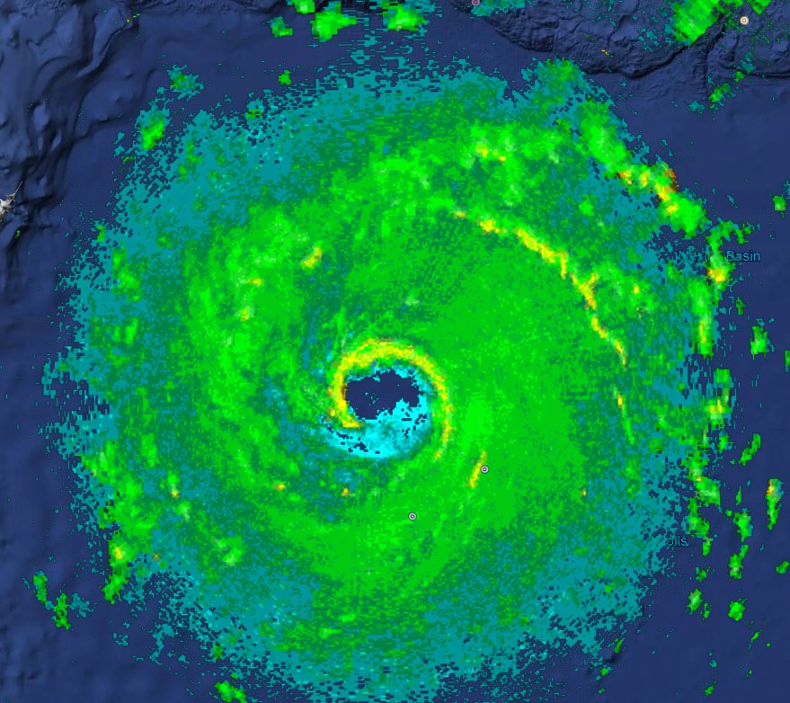
ATL: HARVEY - Post-Tropical - Discussion

Moderator: S2k Moderators

Message
Author
Chris_in_Tampa
Category 5
Category 5
Posts: 5075
Age: 42
Joined: Thu Jun 21, 2007 11:06 pm
Location: Tampa, Florida, USA
Contact:

Re: ATL: HARVEY - Hurricane - Discussion

#2261 Postby Chris_in_Tampa » Thu Aug 24, 2017 2:04 pm

Chris_in_Tampa wrote:
Aric Dunn wrote:Something is wrong with the recon data lol

Aircraft static air pressure is missing and the extrapolated surface pressure column is gone. My system is not designed to allow for the aircraft static air pressure to be missing and coded like "////". NHOP (http://www.ofcm.gov/publications/nhop/nhop2.htm) doesn't specify that. I'll try to make some adjustments.

URNT15 KWBC 241756
NOAA2 1309A HARVEY HDOB 20 20170824
[deleted for clarity]
175500 2255N 09249W 7892 02116 0058 +171 +107 220020 020 012 001 00
175530 2255N 09247W //// 02109 +168 +107 221020 021 012 002 23
175600 2253N 09246W //// 02117 +168 +106 222019 019 015 001 20

0058 is the column for extrapolated surface pressure (or d-value). Missing in later obs. And where you see "////" that should never be coded as missing.


I have added the messages manually after I made a manual adjustment to my recon system. The system will not handle it in real time yet. I have to add the missing column in manually. I think I might temporarily have the system add that column if missing. Until then, I have to manually add each HDOB that is not correct.
1 likes   

User avatar
Cunxi Huang
Category 1
Category 1
Posts: 329
Age: 27
Joined: Thu Sep 26, 2013 12:17 pm
Location: San Jose, CA
Contact:

Re: ATL: HARVEY - Hurricane - Discussion

#2262 Postby Cunxi Huang » Thu Aug 24, 2017 2:05 pm

holy cow...873 mb, only 1 mb higher than Patricia? :D :eek: I would love to see one 870's anywhere in Atlantic but not here where close to land.

Image
Image
2 likes   
06 SuTY SAOMAI | 09 TY LINFA | 10 TY FANAPI | 10 SuTY MEGI | 16 SuTY MERANTI | 19 SuTY LEKIMA | 24 C2 FRANCINE
DO NOT use my posts for life and death decisions. For official information, please refer to products from your RSMC and national weather agency.

WeatherCat
S2K Supporter
S2K Supporter
Posts: 19
Joined: Tue Jul 26, 2011 3:28 pm
Location: Houston/Galveston, TX

Re: ATL: HARVEY - Hurricane - Discussion

#2263 Postby WeatherCat » Thu Aug 24, 2017 2:08 pm

Sharing disturbing new update from Jeff Lindner ... don't understand "not including Galveston Bay" and it's probably a typo since the Bay is west of High Island:


Special Advisory: 100pm Update (cat 3...125mph expected)

Harvey continues into rapid intensification…pressure down to 979mb and winds sustained to 85mph.

100pm forecast now brings strong cat 3 (125mph sustained) into the middle TX coast…cat 4 is possible.

This is a life threatening hurricane and rainfall situation.

Preparations to protect life and property MUST be rushed to completion.

Numerous evacuation orders are now in effect….follow orders immediately….persons in the hurricane warning area need to heed recommendations by local officials.

***Storm Surge warning extended to High Island…not including Galveston Bay***

New Evacuation Orders:

West end Galveston Island (voluntary evacuation order in place)

Mandatory Evac: City of Portland

Will get new impacts out after the 400pm NHC advisory package…biggest change at 100pm:

Raise storm surge values from Sargent to Jamaica Beach: 5-8 ft

Storm Surge Inundation link:

http://www.nhc.noaa.gov/refresh/graphic ... n#contents
Last edited by WeatherCat on Thu Aug 24, 2017 2:09 pm, edited 1 time in total.
0 likes   
__________

The above post is NOT an official forecast and should not be used as such. It is the opinion of the poster and may or may not be backed by sound meteorological data. WeatherCat posts are NOT endorsed by any professional institution, including storm2k.org. For official information, please refer to NHC and NWS products.

Aric Dunn
Category 5
Category 5
Posts: 21238
Age: 42
Joined: Sun Sep 19, 2004 9:58 pm
Location: Ready for the Chase.
Contact:

Re: ATL: HARVEY - Hurricane - Discussion

#2264 Postby Aric Dunn » Thu Aug 24, 2017 2:08 pm

Chris_in_Tampa wrote:
Aric Dunn wrote:Something is wrong with the recon data lol

Aircraft static air pressure is missing and the extrapolated surface pressure column is gone. My system is not designed to allow for the aircraft static air pressure to be missing and coded like "////". NHOP (http://www.ofcm.gov/publications/nhop/nhop2.htm) doesn't specify that. I'll try to make some adjustments.

URNT15 KWBC 241756
NOAA2 1309A HARVEY HDOB 20 20170824
[deleted for clarity]
175500 2255N 09249W 7892 02116 0058 +171 +107 220020 020 012 001 00
175530 2255N 09247W //// 02109 +168 +107 221020 021 012 002 23
175600 2253N 09246W //// 02117 +168 +106 222019 019 015 001 20

0058 is the column for extrapolated surface pressure (or d-value). Missing in later obs. And where you see "////" that should never be coded as missing.


I have added the messages manually after I made a manual adjustment to my recon system. The system will not handle it in real time yet. I have to add the missing column in manually. I think I might temporarily have the system add that column if missing. Until then, I have to manually add each HDOB that is not correct.

Thank you !
0 likes   
Note: If I make a post that is brief. Please refer back to previous posts for the analysis or reasoning. I do not re-write/qoute what my initial post said each time.
If there is nothing before... then just ask :)

Space & Atmospheric Physicist, Embry-Riddle Aeronautical University,
I believe the sky is falling...

Nederlander
S2K Supporter
S2K Supporter
Posts: 1251
Joined: Sat Jul 19, 2008 4:28 pm
Location: Conroe, TX

Re: ATL: HARVEY - Hurricane - Discussion

#2265 Postby Nederlander » Thu Aug 24, 2017 2:09 pm

Cunxi Huang wrote:holy cow...873 mb, only 1 mb higher than Patricia? :D :eek: I would love to see one 870's anywhere in Atlantic but not here where close to land.


Don't think it's got the time to get near that pressure unless it stays offshore.. that would be a drop of about 3mb per hour up until projected landfall.
2 likes   

User avatar
Cuda17
S2K Supporter
S2K Supporter
Posts: 85
Age: 48
Joined: Mon Jan 03, 2011 5:03 pm
Location: Bellville, TX

Re: ATL: HARVEY - Hurricane - Discussion

#2266 Postby Cuda17 » Thu Aug 24, 2017 2:11 pm

Aric Dunn wrote:Its about that time. Looks like an eye is about to clear out shortly.


Also its unlikely that was dry air intrusion.


I agree, looks more like shadows from the towers on the North eye wall.
2 likes   
Personal Forecast Disclaimer:
The posts in this forum are NOT official forecast and should not be used as such. They are just the opinion of the poster and may or may not be backed by sound meteorological data. They are NOT endorsed by any professional institution or storm2k.org. For official information, please refer to the NHC and NWS products.

User avatar
lrak
S2K Supporter
S2K Supporter
Posts: 1770
Age: 58
Joined: Thu Jun 21, 2007 2:48 pm
Location: Corpus Christi, TX

Re: ATL: HARVEY - Hurricane - Discussion

#2267 Postby lrak » Thu Aug 24, 2017 2:13 pm

Volunteer evacuation for CC TX and Mandatory for Port Aransas.
0 likes   
AKA karl

Also
Personal Forecast Disclaimer:
My posts on this forum are NOT official forecast and should not be used as such. My posts are my basic observations and are definitely not backed by any "well some" meteorological knowledge. For official information, please refer to the NHC and NWS products.

User avatar
NDG
S2K Supporter
S2K Supporter
Posts: 15449
Joined: Sun Jul 09, 2006 10:14 pm
Location: Orlando, FL

Re: ATL: HARVEY - Hurricane - Discussion

#2268 Postby NDG » Thu Aug 24, 2017 2:14 pm

GOM big picture, Harvey and 92L's circulation off of the coast of Ft Myers, if it was not for the big outflow from Harvey we would had been seen to named systems in the GOM.

Image
0 likes   

User avatar
GCANE
S2K Supporter
S2K Supporter
Posts: 11509
Joined: Mon Oct 22, 2007 8:03 am

Re: ATL: HARVEY - Hurricane - Discussion

#2269 Postby GCANE » Thu Aug 24, 2017 2:15 pm

Cuda17 wrote:
Aric Dunn wrote:Its about that time. Looks like an eye is about to clear out shortly.


Also its unlikely that was dry air intrusion.


I agree, looks more like shadows from the towers on the North eye wall.


Yup, very likely.
0 likes   

User avatar
cycloneye
Admin
Admin
Posts: 145799
Age: 68
Joined: Thu Oct 10, 2002 10:54 am
Location: San Juan, Puerto Rico

Re: ATL: HARVEY - Hurricane - Discussion

#2270 Postby cycloneye » Thu Aug 24, 2017 2:18 pm

@GregPostel
There's apparently a lot of lightning in the eyewall convection, roughly 250 miles SE of Brownsville, TX #hurricane #Harvey #txwx #lawx.


Image


 https://twitter.com/GregPostel/status/900797479570092033


0 likes   
Visit the Caribbean-Central America Weather Thread where you can find at first post web cams,radars
and observations from Caribbean basin members Click Here

User avatar
GCANE
S2K Supporter
S2K Supporter
Posts: 11509
Joined: Mon Oct 22, 2007 8:03 am

Re: ATL: HARVEY - Hurricane - Discussion

#2271 Postby GCANE » Thu Aug 24, 2017 2:18 pm

I don't think I have seen a tower spin around and build so fast before.
Truly remarkable.
1 likes   

Javlin
Category 5
Category 5
Posts: 1621
Age: 64
Joined: Fri Jul 09, 2004 7:58 pm
Location: ms gulf coast

Re: ATL: HARVEY - Hurricane - Discussion

#2272 Postby Javlin » Thu Aug 24, 2017 2:20 pm

Best pic I have seen of 92L in days.If the last VDM is a location of the center it appears a to still be NNW-N if that's the case.it appears to my eyes the UUL is directly to it's W in Mexico.
http://www.atmos.washington.edu/~ovens/ ... nhanced+24
0 likes   

User avatar
KWT
Category 5
Category 5
Posts: 31415
Joined: Tue Aug 17, 2004 11:02 am
Location: UK!!!

Re: ATL: HARVEY - Hurricane - Discussion

#2273 Postby KWT » Thu Aug 24, 2017 2:20 pm

Lots of lightning is very suggestive of a rapidly strengthening eyewall, very efficient at bringing down some very high winds down to the surface.
2 likes   
Personal Forecast Disclaimer:
The posts in this forum are NOT official forecast and should not be used as such. They are just the opinion of the poster and may or may not be backed by sound meteorological data. They are NOT endorsed by any professional institution or storm2k.org. For official information, please refer to the NHC and NWS products

AxaltaRacing24
Category 5
Category 5
Posts: 1755
Age: 25
Joined: Wed Jul 27, 2016 11:14 am
Location: Jupiter, FL

Re: ATL: HARVEY - Hurricane - Discussion

#2274 Postby AxaltaRacing24 » Thu Aug 24, 2017 2:23 pm

This looks like it is going to explode into a monster.
Image
0 likes   

SunnyThoughts
Category 5
Category 5
Posts: 2263
Joined: Wed Jul 09, 2003 12:42 pm
Location: Pensacola, Florida

Re: ATL: HARVEY - Hurricane - Discussion

#2275 Postby SunnyThoughts » Thu Aug 24, 2017 2:23 pm

When is the next AF hurricane hunter mission scheduled to head out?
0 likes   

Aric Dunn
Category 5
Category 5
Posts: 21238
Age: 42
Joined: Sun Sep 19, 2004 9:58 pm
Location: Ready for the Chase.
Contact:

Re: ATL: HARVEY - Hurricane - Discussion

#2276 Postby Aric Dunn » Thu Aug 24, 2017 2:24 pm

NDG wrote:GOM big picture, Harvey and 92L's circulation off of the coast of Ft Myers, if it was not for the big outflow from Harvey we would had been seen to named systems in the GOM.


However its that said outflow that will give life to our next system.
2 likes   
Note: If I make a post that is brief. Please refer back to previous posts for the analysis or reasoning. I do not re-write/qoute what my initial post said each time.
If there is nothing before... then just ask :)

Space & Atmospheric Physicist, Embry-Riddle Aeronautical University,
I believe the sky is falling...

User avatar
AubreyStorm
Category 1
Category 1
Posts: 337
Age: 44
Joined: Fri Jun 16, 2017 6:21 pm
Location: Texas, USA

Re: ATL: HARVEY - Hurricane - Discussion

#2277 Postby AubreyStorm » Thu Aug 24, 2017 2:24 pm

NOAA hurricane hunter radar scan courtesy of @TropicalATL shows well-defined, nearly closed eyewall of #Harvey at 1:30pm CDT.

Image
2 likes   
The posts are NOT an official forecast. Please REFER to the NHC and NWS for official forecasts and products.

User avatar
Kazmit
Category 5
Category 5
Posts: 2125
Age: 22
Joined: Mon Jul 25, 2016 8:49 am
Location: Williamsburg, VA / Bermuda

Re: ATL: HARVEY - Hurricane - Discussion

#2278 Postby Kazmit » Thu Aug 24, 2017 2:26 pm

And to think this was a disorganized tropical depression less than 24 hours ago...
0 likes   
Igor 2010, Sandy 2012, Fay 2014, Gonzalo 2014, Joaquin 2015, Nicole 2016, Humberto 2019

I am only a tropical weather enthusiast. My predictions are not official and may or may not be backed by sound meteorological data. For official information, please refer to the NHC and NWS products.

Aric Dunn
Category 5
Category 5
Posts: 21238
Age: 42
Joined: Sun Sep 19, 2004 9:58 pm
Location: Ready for the Chase.
Contact:

Re: ATL: HARVEY - Hurricane - Discussion

#2279 Postby Aric Dunn » Thu Aug 24, 2017 2:26 pm

AubreyStorm wrote:NOAA hurricane hunter radar scan courtesy of @TropicalATL shows well-defined, nearly closed eyewall of #Harvey at 1:30pm CDT.


The rate of inner core orginization is pretty amazing. I still we have a major by 11pm.

Also that image was before its current state of convection all the wat around. Next pass will be closed
1 likes   
Note: If I make a post that is brief. Please refer back to previous posts for the analysis or reasoning. I do not re-write/qoute what my initial post said each time.
If there is nothing before... then just ask :)

Space & Atmospheric Physicist, Embry-Riddle Aeronautical University,
I believe the sky is falling...

User avatar
AdamFirst
S2K Supporter
S2K Supporter
Posts: 2491
Age: 36
Joined: Thu Aug 14, 2008 10:54 am
Location: Port Saint Lucie, FL

Re: ATL: HARVEY - Hurricane - Discussion

#2280 Postby AdamFirst » Thu Aug 24, 2017 2:28 pm

Taylormae wrote:I understand this is several days out but what, if any, effects will reach Pensacola, FL? Wondering how prepared we should be.
Thank you all.


Way too early to say. May lift north well before Pensacola. Keep an eye on the forecasts.
1 likes   
Dolphins Marlins Canes Golden Panthers HEAT
Andrew 1992 - Irene 1999 - Frances 2004 - Jeanne 2004 - Wilma 2005 - Fay 2008 - Isaac 2012 - Matthew 2016 - Irma 2017 - Dorian 2019 - Ian 2022 - Nicole 2022 - Milton 2024


Return to “2017”

Who is online

Users browsing this forum: No registered users and 5 guests