

ATL: FRANKLIN - Remnants - Discussion
Moderator: S2k Moderators
-
wxman57

- Moderator-Pro Met

- Posts: 23174
- Age: 68
- Joined: Sat Jun 21, 2003 8:06 pm
- Location: Houston, TX (southwest)
Re: ATL: INVEST 90L - Discussion
RL3AO wrote:wxman57 wrote:panamatropicwatch wrote:Kind of surprised with only 60% during five day time frame.
I'm not surprised. If they went higher, at least in the 48hr time frame, they'd have to start potential tropical cyclone advisories, as the system will be affecting land within 48 hrs. I'm sure that fact will govern how high they go within 48hrs. I think I'd go 60/90 now.
I still think they will hold off PTC advisories until genesis is almost certain (at least 90 within 48 hrs).
When I met with them in April, they said that they would be quite "cautious" at first when issuing PTCs, meaning not until they were fairly certain development would occur within 36 hrs.
2 likes
Re: ATL: INVEST 90L - Discussion
Afternoon popups now firing over PR and DR.
TUTT weakening.
Expect to see a poleward outflow channel to kick in.
90L already has a good UL Divergence.
TUTT weakening.
Expect to see a poleward outflow channel to kick in.
90L already has a good UL Divergence.
1 likes
-
lrak

- S2K Supporter

- Posts: 1770
- Age: 59
- Joined: Thu Jun 21, 2007 2:48 pm
- Location: Corpus Christi, TX
Re: ATL: INVEST 90L - Discussion
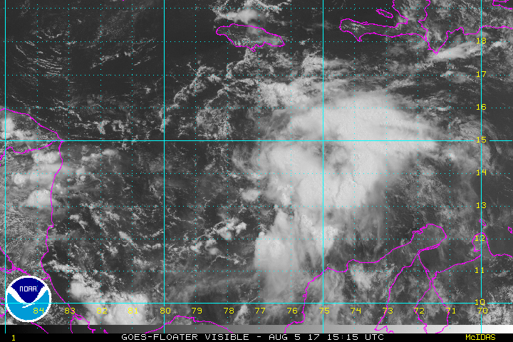
I see a fast swirl at about 15N 76W, is that the center?
https://weather.msfc.nasa.gov/cgi-bin/get-goes?satellite=GOES-E%20CONUS&lat=15&lon=-76&info=vis&zoom=1&width=1000&height=800&quality=90&type=Animation&palette=ir1.pal&numframes=30&mapcolor=yellow
https://weather.msfc.nasa.gov/cgi-bin/get-goes?satellite=GOES-E%20CONUS&lat=15&lon=-76&info=vis&zoom=1&width=1000&height=800&quality=90&type=Animation&palette=ir1.pal&numframes=30&mapcolor=yellow
0 likes
AKA karl
Also
Personal Forecast Disclaimer:
My posts on this forum are NOT official forecast and should not be used as such. My posts are my basic observations and are definitely not backed by any "well some" meteorological knowledge. For official information, please refer to the NHC and NWS products.
Also
Personal Forecast Disclaimer:
My posts on this forum are NOT official forecast and should not be used as such. My posts are my basic observations and are definitely not backed by any "well some" meteorological knowledge. For official information, please refer to the NHC and NWS products.
Re: ATL: INVEST 90L - Discussion
Looking at some of the small rising Cu Nims to the west of the circulation, it looks like west winds are nearly at the surface.
1 likes
-
lrak
- S2K Supporter
- Posts: 1770
- Age: 59
- Joined: Thu Jun 21, 2007 2:48 pm
- Location: Corpus Christi, TX
Re: ATL: INVEST 90L - Discussion
I can't believe how large it's grown today. From the northern tip of SA to the top of the Central-Caribbean 
0 likes
AKA karl
Also
Personal Forecast Disclaimer:
My posts on this forum are NOT official forecast and should not be used as such. My posts are my basic observations and are definitely not backed by any "well some" meteorological knowledge. For official information, please refer to the NHC and NWS products.
Also
Personal Forecast Disclaimer:
My posts on this forum are NOT official forecast and should not be used as such. My posts are my basic observations and are definitely not backed by any "well some" meteorological knowledge. For official information, please refer to the NHC and NWS products.

Re: ATL: INVEST 90L - Discussion
Quite impressive today. I wasn't expecting it to get this organized yet, though for some reason I'm always surprised at how these waves come back after escaping the central Caribbean, despite having seen it so often.
2 likes
The above post is not official and should not be used as such. It is the opinion of the poster and may or may not be backed by sound meteorological data. It is not endorsed by any professional institution or storm2k.org. For official information, please refer to the NHC and NWS products.
-
tropicwatch

- Category 5

- Posts: 3426
- Age: 62
- Joined: Sat Jun 02, 2007 10:01 am
- Location: The Villages, Florida
- Contact:
Re: ATL: INVEST 90L - Discussion
Pressure falling in the western Caribbean. Station 42057 - Western Caribbean - 195 NM WSW of Negril, Jamaica at 4pm reported a pressure of 1011mb. This is 1.2mb's lower then yesterday's pressure at the same time and lower than anytime after that report.
0 likes
Tropicwatch
Agnes 72', Eloise 75, Elena 85', Kate 85', Charley 86', Florence 88', Beryl 94', Dean 95', Erin 95', Opal 95', Earl 98', Georges 98', Ivan 2004', Arlene 2005', Dennis 2005', Ida 2009' Debby 2012' Irma 2017' Michael 2018'
Agnes 72', Eloise 75, Elena 85', Kate 85', Charley 86', Florence 88', Beryl 94', Dean 95', Erin 95', Opal 95', Earl 98', Georges 98', Ivan 2004', Arlene 2005', Dennis 2005', Ida 2009' Debby 2012' Irma 2017' Michael 2018'
-
lrak
- S2K Supporter
- Posts: 1770
- Age: 59
- Joined: Thu Jun 21, 2007 2:48 pm
- Location: Corpus Christi, TX
Re: ATL: INVEST 90L - Discussion
https://noaahrd.wordpress.com/2015/08/06/35th-anniversary-of-hurricane-allen/ Scooby is saying "ruh roh" a little north of were 90L is but sure looks like him. Allen was my first Hurricane Swell  I almost drown
  lesson learned check your leash before heading out into 10 feet seas. Never found my board after it broke off. I thought I was a gonner.
1 likes
AKA karl
Also
Personal Forecast Disclaimer:
My posts on this forum are NOT official forecast and should not be used as such. My posts are my basic observations and are definitely not backed by any "well some" meteorological knowledge. For official information, please refer to the NHC and NWS products.
Also
Personal Forecast Disclaimer:
My posts on this forum are NOT official forecast and should not be used as such. My posts are my basic observations and are definitely not backed by any "well some" meteorological knowledge. For official information, please refer to the NHC and NWS products.


Re: ATL: INVEST 90L - Models
GFS much more organized before the Yucatán, 1007mb TS by 48 hours.
0 likes

Re: ATL: INVEST 90L - Discussion
um I would watch for center reformation in this early stage...js
1 likes
Re: ATL: INVEST 90L - Models
Cpv17 wrote:The Euro appears to be initializing the storm too far to the south. Once we actually have a closed area of low pressure for the models to initialize from then we'll have a much better idea of where this is headed.
agree with this
0 likes
-
cycloneye

- Admin

- Posts: 149471
- Age: 69
- Joined: Thu Oct 10, 2002 10:54 am
- Location: San Juan, Puerto Rico
Re: ATL: INVEST 90L - Models
18z GFS stronger in BOC than past runs.

0 likes
Visit the Caribbean-Central America Weather Thread where you can find at first post web cams,radars
and observations from Caribbean basin members Click Here
and observations from Caribbean basin members Click Here
-
lrak
- S2K Supporter
- Posts: 1770
- Age: 59
- Joined: Thu Jun 21, 2007 2:48 pm
- Location: Corpus Christi, TX
Re: ATL: INVEST 90L - Models
cycloneye wrote:18z GFS stronger in BOC than past runs.
and the high pressure over S. TX has decreased as well.
0 likes
AKA karl
Also
Personal Forecast Disclaimer:
My posts on this forum are NOT official forecast and should not be used as such. My posts are my basic observations and are definitely not backed by any "well some" meteorological knowledge. For official information, please refer to the NHC and NWS products.
Also
Personal Forecast Disclaimer:
My posts on this forum are NOT official forecast and should not be used as such. My posts are my basic observations and are definitely not backed by any "well some" meteorological knowledge. For official information, please refer to the NHC and NWS products.
-
lrak
- S2K Supporter
- Posts: 1770
- Age: 59
- Joined: Thu Jun 21, 2007 2:48 pm
- Location: Corpus Christi, TX
Re: ATL: INVEST 90L - Discussion
ROCK wrote:um I would watch for center reformation in this early stage...js
wow could it be a replacement about 100 miles north?
0 likes
AKA karl
Also
Personal Forecast Disclaimer:
My posts on this forum are NOT official forecast and should not be used as such. My posts are my basic observations and are definitely not backed by any "well some" meteorological knowledge. For official information, please refer to the NHC and NWS products.
Also
Personal Forecast Disclaimer:
My posts on this forum are NOT official forecast and should not be used as such. My posts are my basic observations and are definitely not backed by any "well some" meteorological knowledge. For official information, please refer to the NHC and NWS products.
-
tropicwatch
- Category 5
- Posts: 3426
- Age: 62
- Joined: Sat Jun 02, 2007 10:01 am
- Location: The Villages, Florida
- Contact:
Re: ATL: INVEST 90L - Discussion
Kind of looks like the circulation might be consolidating closer to the large area of convection.
3 likes
Tropicwatch
Agnes 72', Eloise 75, Elena 85', Kate 85', Charley 86', Florence 88', Beryl 94', Dean 95', Erin 95', Opal 95', Earl 98', Georges 98', Ivan 2004', Arlene 2005', Dennis 2005', Ida 2009' Debby 2012' Irma 2017' Michael 2018'
Agnes 72', Eloise 75, Elena 85', Kate 85', Charley 86', Florence 88', Beryl 94', Dean 95', Erin 95', Opal 95', Earl 98', Georges 98', Ivan 2004', Arlene 2005', Dennis 2005', Ida 2009' Debby 2012' Irma 2017' Michael 2018'
Re: ATL: INVEST 90L - Discussion
Nice tower 13.5N 77.5W.
Firing close into the LLC.
Looks likely this will continue to strengthen overnight.
TPW and UL Outflow all improving.


Firing close into the LLC.
Looks likely this will continue to strengthen overnight.
TPW and UL Outflow all improving.
1 likes
Re: ATL: INVEST 90L - Discussion
If you watch around 12N/77W the low level flow earlier was out of the south, now it's from the SW-WSW so it seems like a LLC might be trying to form near 14N.
0 likes
The above post is not official and should not be used as such. It is the opinion of the poster and may or may not be backed by sound meteorological data. It is not endorsed by any professional institution or storm2k.org. For official information, please refer to the NHC and NWS products.
-
TropicalAnalystwx13

- Category 5
- Posts: 2109
- Age: 28
- Joined: Tue Jul 19, 2011 8:20 pm
- Location: Wilmington, NC
- Contact:
Re: ATL: INVEST 90L - Discussion
Barring some last minute southward shift, this is probably going to have ample time to develop into a named storm prior to the Yucatan, and it may be near or at hurricane intensity while making landfall in central Mexico.
2 likes
-
MGC

- S2K Supporter
- Posts: 5940
- Joined: Sun Mar 23, 2003 9:05 pm
- Location: Pass Christian MS, or what is left.
Re: ATL: INVEST 90L - Discussion
90L has continued to get better organized today. 8pm TWO should bump up the odds of development considerably. Would not be surprised if recon finds a TD or TS tomorrow.....MGC
1 likes
Who is online
Users browsing this forum: No registered users and 29 guests