
Product: NOAA Vortex Message (URNT12 KWBC)
Transmitted: 4th day of the month at 10:50Z
Agency: National Oceanic and Atmospheric Administration (NOAA)
Aircraft: Lockheed WP-3D Orion (Reg. Num. N42RF)
Storm Number & Year: 11 in 2017
Storm Name: Irma (flight in the North Atlantic basin)
Mission Number: 2
Observation Number: 12 ( See all messages of this type for this mission. )
A. Time of Center Fix: 4th day of the month at 10:27:07Z
B. Center Fix Coordinates: 16°47'N 52°21'W (16.7833N 52.35W)
B. Center Fix Location: 547 statute miles (880 km) to the ENE (62°) from Bridgetown, Barbados.
C. Minimum Height at Standard Level: 2,655m (8,711ft) at 700mb
D. Estimated (by SFMR or visually) Maximum Surface Wind Inbound: 89kts (~ 102.4mph)
E. Location of the Estimated Maximum Surface Wind Inbound: 5 nautical miles (6 statute miles) to the SSW (207°) of center fix
F. Maximum Flight Level Wind Inbound: From 312° at 95kts (From the NW at ~ 109.3mph)
G. Location of Maximum Flight Level Wind Inbound: 7 nautical miles (8 statute miles) to the SSW (211°) of center fix
H. Minimum Sea Level Pressure: 948mb (28.00 inHg)
I. Maximum Flight Level Temp & Pressure Altitude Outside Eye: 11°C (52°F) at a pressure alt. of 2,989m (9,806ft)
J. Maximum Flight Level Temp & Pressure Altitude Inside Eye: 14°C (57°F) at a pressure alt. of 3,334m (10,938ft)
K. Dewpoint Temp (collected at same location as temp inside eye): 12°C (54°F)
K. Sea Surface Temp (collected at same location as temp inside eye): Not Available
L. Eye Character: Closed
M. Eye Shape & Diameter: Circular with a diameter of 18 nautical miles (21 statute miles)
N. Fix Determined By: Penetration, Radar, Wind, Pressure and Temperature
N. Fix Level: 700mb
O. Navigational Fix Accuracy: 0.1 nautical miles
O. Meteorological Accuracy: 1 nautical mile
Remarks Section - Remarks That Were Decoded...
Maximum Flight Level Wind: 117kts (~ 134.6mph) which was observed 12 nautical miles (14 statute miles) to the NW (315°) from the flight level center at 9:06:56Z
Maximum Flight Level Wind Outbound: 109kts (~ 125.4mph) which was observed 10 nautical miles (12 statute miles) to the NE (42°) from the flight level center at 10:29:44Z
Dropsonde Surface Wind at Center: From 80° at 10kts (From the E at 12mph)
Remarks Section - Additional Remarks...
EYEWALL WEAKER NW THROUGH NE
ATL: IRMA - Post-Tropical - Discussion
Moderator: S2k Moderators
-
Hurricaneman

- Category 5

- Posts: 7404
- Age: 45
- Joined: Tue Aug 31, 2004 3:24 pm
- Location: central florida
Re: ATL: IRMA - Hurricane - Discussion
Looks to be about to bottom out on latitude and possibly pressure later on today so the islands really need to hunker down and get ready for this
0 likes
-
WeatherGuesser
- Category 5
- Posts: 2672
- Joined: Tue Jun 29, 2010 6:46 am
Re: ATL: IRMA - Hurricane - Discussion
Hurricaneman wrote:Looks to be about to bottom out on latitude and possibly pressure later on today so the islands really need to hunker down and get ready for this
Every time somebody posts that, it goes further south and gets deeper.
1 likes
-
Chris_in_Tampa
- Category 5
- Posts: 5101
- Age: 42
- Joined: Thu Jun 21, 2007 11:06 pm
- Location: Tampa, Florida, USA
- Contact:
Re: ATL: IRMA - Main Recon Thread (Data only)
Just an FYI, checking NOAA's server, last radar scan available from NOAA, for current Monday morning P-3 mission into Irma, was available at 5:47am AST.
This was the last available image of this type from the center, at 5:04am EDT:

Credit: NOAA-AOC
I get images like this just for the center and then the normal scans every 5 minutes for Google Earth usually.
This was the last available image of this type from the center, at 5:04am EDT:
Credit: NOAA-AOC
I get images like this just for the center and then the normal scans every 5 minutes for Google Earth usually.
1 likes
Re: ATL: IRMA - Hurricane - Discussion
WeatherGuesser wrote:Hurricaneman wrote:Looks to be about to bottom out on latitude and possibly pressure later on today so the islands really need to hunker down and get ready for this
Every time somebody posts that, it goes further south and gets deeper.
Maybe so but if you look at recon the eye has actually shifted slightly N of W. The drops in latitude maybe over.
0 likes
Re: ATL: IRMA - Hurricane - Discussion
Latest Water Temp vs Depth Profile from Kermit
Product: Bathythermal Data (SOFX01 KWBC)
Date Profile Data was Processed: September 4th, 2017 at 10:31:49Z
Agency: National Oceanic and Atmospheric Administration (NOAA)
Aircraft: Lockheed WP-3D Orion (Reg. Num. N42RF)
Storm Number: 11L in 2017 (flight in the North Atlantic basin)
AXBT Buoy Drop (Airborne eXpendable Bathythermograph)
Profile Date: September 4th, 2017
Profile Time: 10:20:43Z
Profile Coordinates: 16.474N 52.654W
Profile Location: 519 statute miles (836 km) to the ENE (63°) from Bridgetown, Barbados.
AXBT Channel: 12
Sea Surface Temperature: 27.14°C (80.9°F)
Depth of 26°C Isotherm: 19.5 m (64 ft)
Deepest Depth of AXBT: 76.5 m (251 ft)
AXBT Diagram...
0 likes
-
Hurricaneman
- Category 5
- Posts: 7404
- Age: 45
- Joined: Tue Aug 31, 2004 3:24 pm
- Location: central florida
Re: ATL: IRMA - Hurricane - Discussion
tiger_deF wrote:WeatherGuesser wrote:Hurricaneman wrote:Looks to be about to bottom out on latitude and possibly pressure later on today so the islands really need to hunker down and get ready for this
Every time somebody posts that, it goes further south and gets deeper.
Maybe so but if you look at recon the eye has actually shifted slightly N of W. The drops in latitude maybe over.
Maybe 265 movement from recon
0 likes
-
tolakram
- Admin

- Posts: 20186
- Age: 62
- Joined: Sun Aug 27, 2006 8:23 pm
- Location: Florence, KY (name is Mark)
Re: ATL: IRMA - Hurricane - Discussion
Remember you can't get movement from recon over 2 or even 3 drops due to the fact the drops are not always centered.

1 likes
M a r k
- - - - -
Join us in chat: Storm2K Chatroom Invite. Android and IOS apps also available.
The posts in this forum are NOT official forecasts and should not be used as such. Posts are NOT endorsed by any professional institution or STORM2K.org. For official information and forecasts, please refer to NHC and NWS products.

-
northjaxpro

- S2K Supporter

- Posts: 8900
- Joined: Mon Sep 27, 2010 11:21 am
- Location: Jacksonville, FL
Re: ATL: IRMA - Hurricane - Discussion
Yeah I'm looking at the imagery now. It appears this morning Irma has level out and is moving due west at the moment, slightly north of due west. .Hopefully we will have no more south of west motion pertain to our neighbors down in the islands. I pray that all are getting prepared and ready over in the Northeast Caribbean islands for Irma's approach.
Last edited by northjaxpro on Mon Sep 04, 2017 6:17 am, edited 1 time in total.
1 likes
NEVER, EVER SAY NEVER in the tropics and weather in general, and most importantly, with life itself!!
________________________________________________________________________________________
Fay 2008 Beryl 2012 Debby 2012 Colin 2016 Hermine 2016 Julia 2016 Matthew 2016 Irma 2017 Dorian 2019
________________________________________________________________________________________
Fay 2008 Beryl 2012 Debby 2012 Colin 2016 Hermine 2016 Julia 2016 Matthew 2016 Irma 2017 Dorian 2019
-
tolakram
- Admin
- Posts: 20186
- Age: 62
- Joined: Sun Aug 27, 2006 8:23 pm
- Location: Florence, KY (name is Mark)
Re: ATL: IRMA - Hurricane - Discussion
https://twitter.com/EricBlake12/status/904660429825339392
Eric Blake ✔ @EricBlake12
The @NOAA_HurrHunter radar data is invaluable to see the inner core of #Irma- look at the similar eyewall mesovortices also seen in #Harvey
7:00 AM - Sep 4, 2017

These images are from TropicalAtlantic
http://tropicalatlantic.com/recon/recon.cgi?basin=al&year=2017&storm=Irma
Eric Blake ✔ @EricBlake12
The @NOAA_HurrHunter radar data is invaluable to see the inner core of #Irma- look at the similar eyewall mesovortices also seen in #Harvey
7:00 AM - Sep 4, 2017
These images are from TropicalAtlantic
http://tropicalatlantic.com/recon/recon.cgi?basin=al&year=2017&storm=Irma
1 likes
M a r k
- - - - -
Join us in chat: Storm2K Chatroom Invite. Android and IOS apps also available.
The posts in this forum are NOT official forecasts and should not be used as such. Posts are NOT endorsed by any professional institution or STORM2K.org. For official information and forecasts, please refer to NHC and NWS products.
- - - - -
Join us in chat: Storm2K Chatroom Invite. Android and IOS apps also available.
The posts in this forum are NOT official forecasts and should not be used as such. Posts are NOT endorsed by any professional institution or STORM2K.org. For official information and forecasts, please refer to NHC and NWS products.
-
Big Easy Breeze
- Tropical Depression

- Posts: 76
- Joined: Mon Aug 28, 2017 7:52 am
Re: ATL: IRMA - Hurricane - Discussion
WeatherGuesser wrote:IF it gets into the GOM, then what?
Depending on the trend; evacuate your area immediately. There will be no room for error.
This hurricane eerily reminds me of the trends with Katrina. People kept doubting the westward trends. Then on that Friday evening, all you know what broke loose, when Katrina was within 72 hrs. of landfall at the La/Miss border.
All I can say is. Be vigilante, be aware and most importantly; have a plan to evacuate and to where. DO NOT be planning on a city to evacuate, within 72 hrs. If so, you will find yourself farther away than you would like. Take this from my own personal experience.
If Irma's trend continues and you live in the panhandlev of Fla., east to NC. You should already have a city in mind to evacuate to.
I cannot emphasize enough. Do not ignore the trends. If you do, It will potentially catch you unprepared as far as being able to find a location you would like to evacuate to.
0 likes
Re: ATL: IRMA - Hurricane - Discussion
Nice development in 4 hrs
Top Microwave image at 10:11Z
Bottom at 6:14Z
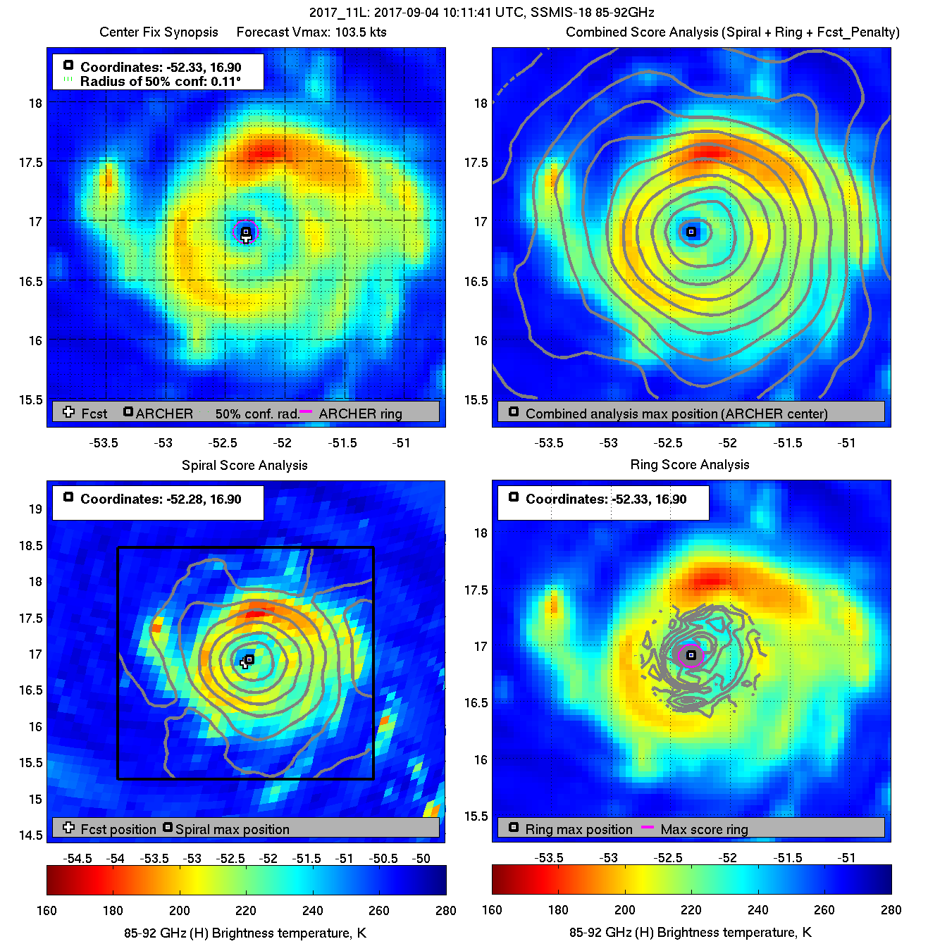
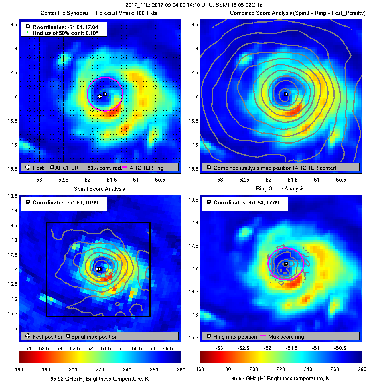
Top Microwave image at 10:11Z
Bottom at 6:14Z
2 likes
-
xtyphooncyclonex

- Category 5
- Posts: 3891
- Age: 24
- Joined: Sat Dec 08, 2012 9:07 am
- Location: Cebu City
- Contact:
Re: ATL: IRMA - Hurricane - Discussion
And so RI begins...

1 likes
REMINDER: My opinions that I, or any other NON Pro-Met in this forum, are unofficial. Please do not take my opinions as an official forecast and warning. I am NOT a meteorologist. Following my forecasts blindly may lead to false alarm, danger and risk if official forecasts from agencies are ignored.
-
jlauderdal
- S2K Supporter
- Posts: 7240
- Joined: Wed May 19, 2004 5:46 am
- Location: NE Fort Lauderdale
- Contact:
Re: ATL: IRMA - Hurricane - Discussion
Sanibel wrote:GFS suggests a Donna-like nightmare track for us...All these years on the board saying "Donna-like track" and here we are looking at the real thing coming true on the models...This household is now under hurricane emergency status and today will be spent getting ready...Track could still change but there's no sense not preparing for the worst...This is no Charlie...This will be a surger...We're in the "A" zone 300 yards from the beach...
.
not quite an emergency at my place but i did pick up 5 cases of water this morning, they had about 1/2 their stock...my advanced preps will ensure that water goes unused for this event...
this is a good day to stock up on water, you can always use it later and avoid massive lines or worse no water...stay safe...southerly route shredder in play, if that doesnt work someone in the continental united states has a good shot at a major event..be smart, stay safe
also, they arent going to evacuate southern florida even if its a cat 5, as the houston mayor pointed out many times there are too many peeps and they have a better logistical setup in houston then sofla....many houses in sofla are like the bahamas, solid concrete reinforced steel construction like mine...i had a hurricane inspection done 15 years to save money on insurance and the inspector said, this house can easily go to 140 without risk of coming down and he wasnt speculating because look at older houses in the islands that have stood up to major hurricanes, roofs not as strong but consider how far out cat 3-5 winds extend its not that far, there is no reason to evacuate because of wind, surge is a different story
andrew housing had major problems due to really shoddy new construction, if you have an older home you are most likely best to shelter in place
1 likes
Re: ATL: IRMA - Hurricane - Discussion
Seems she took a quick step to the south as she just started to strengthen
May have gone thru a quick EWRC
May have gone thru a quick EWRC
0 likes

Re: ATL: IRMA - Hurricane - Discussion
I'm in the Cocoa area about 2 miles from the coast and I have two small kids. No idea if I should evacuate out of Florida or stay put. I guess time will give us a clearer answer but on Thursday/Friday everything might be a parking lot.
0 likes
-
La Sirena

- Category 1

- Posts: 308
- Joined: Sun Aug 21, 2016 4:02 pm
- Location: Formerly of the Keys, back home in East TN
Re: ATL: IRMA - Hurricane - Discussion
Sanibel wrote:GFS suggests a Donna-like nightmare track for us...All these years on the board saying "Donna-like track" and here we are looking at the real thing coming true on the models...This household is now under hurricane emergency status and today will be spent getting ready...Track could still change but there's no sense not preparing for the worst...This is no Charlie...This will be a surger...We're in the "A" zone 300 yards from the beach...
.
You're making the right decision! I'm hoping others follow suit. We sold our house in the lower Keys and moved around the start of hurricane season this year. If this run came to fruition there would be nothing left of our home I'm sure. We never had to experience a hurricane there and for that I'm grateful. Already reached out to several friends in the Keys offering shelter if they evacuate.
At least we have a week to watch the fierce Miss Irma....hoping all in the southern islands are prepared and fare well.
Last edited by La Sirena on Mon Sep 04, 2017 6:40 am, edited 1 time in total.
0 likes
The posts in this forum are NOT official forecasts and should not be used as such. They are just the opinion of the poster and may or may not be backed by sound meteorological data. They are NOT endorsed by any professional institution or STORM2K. For official information, please refer to products from the NHC and NWS.
Hurricane Irma,Hurricane Michael, Hurricane Helene
-
Hurricaneman
- Category 5
- Posts: 7404
- Age: 45
- Joined: Tue Aug 31, 2004 3:24 pm
- Location: central florida
Re: ATL: IRMA - Hurricane - Discussion
Looks to be heading due west if not just a bit north of due west like a 272 heading righ at 16.7n
0 likes
-
euro6208
Re: ATL: IRMA - Hurricane - Discussion
God bless everyone in the Caribbean Islands, Puerto Rico, and Cuba!
1 likes
Who is online
Users browsing this forum: No registered users and 50 guests