ATL: HARVEY - Models
Moderator: S2k Moderators
-
tarheelprogrammer

- S2K Supporter

- Posts: 1793
- Joined: Mon Mar 28, 2016 9:25 pm
- Location: Raleigh, NC area (Garner, NC)
Re: ATL: HARVEY - Models
Weaker this run, but further in the GOM I believe. It needs to be watched again sadly. They do not need any surge in Houston right now, NONE! 
0 likes
My posts are not official forecasts. They are just my opinion and may or may not be backed by sound meteorological data. They are NOT endorsed by any professional institution or storm2k.org. For official information, please refer to the NHC and NWS products.
-
stormreader
Re: ATL: HARVEY - Models
tolakram wrote:

Okay. I thought that secondary landfall would be Thurs or Fri. Not that Wednesday isn't bad enough.
0 likes
-
TheStormExpert
Re: ATL: HARVEY - Models
Joe Bastardi calling for Harvey to restrengthen to Cat.1 intensity before it's 2nd landfall near the Houston/Galveston area late Tuesday/early Wednesday.
https://twitter.com/BigJoeBastardi/status/901869321554624513
https://twitter.com/BigJoeBastardi/status/901869321554624513
0 likes
-
stormreader
Re: ATL: HARVEY - Models
stormreader wrote:Jagno wrote:As a resident of SW Louisiana I don't like these drawings. Go back and draw a better one please.
Don't blame you. As it stands now, the core has sort of been hollowed out of the storm. Still a very well established cyclonic rotation, though. If models verify, than with center just off Texas coast, more moisture to draw on, the bulk of the precip would be established further north and east of the center than a more tightly wound and developing system. Now if storm reorganizes some in Gulf, it should bring some of that moisture back in more tightly around center, but with a secondary landfall somewhere near Galveston, and then moving north, the Lake Charles area, might still catch as much of that moisture as anyone. And as I look at radar, you guys are catching your "fair share" right now.
But system scheduled to move into E Central Texas, north of the gulf coast Thursday and Fri. There could still be "training" of moisture out of the gulf over SW La especially, as the storm is well to the north in East Texas/.
0 likes
-
stormreader
Re: ATL: HARVEY - Models
TheStormExpert wrote:Joe Bastardi calling for Harvey to restrengthen to Cat.1 intensity before it's 2nd landfall near the Houston/Galveston area late Tuesday/early Wednesday.
https://twitter.com/BigJoeBastardi/status/901869321554624513
If it verifies, it will pull that moisture back in around a reorganizing storm, bringing more danger again to Galveston-Houston as the storm will move right over them (center).
1 likes
-
sphelps8681
- Category 2

- Posts: 785
- Joined: Thu Aug 16, 2007 5:37 pm
- Location: Somewhere over the rainbow
Re: ATL: HARVEY - Models
TheStormExpert wrote:Joe Bastardi calling for Harvey to restrengthen to Cat.1 intensity before it's 2nd landfall near the Houston/Galveston area late Tuesday/early Wednesday.
https://twitter.com/BigJoeBastardi/status/901869321554624513
This would not be good for anyone north and east of that.
1 likes

Re: ATL: HARVEY - Models
stormreader wrote:Jagno wrote:As a resident of SW Louisiana I don't like these drawings. Go back and draw a better one please.
Don't blame you. As it stands now, the core has sort of been hollowed out of the storm. Still a very well established cyclonic rotation, though. If models verify, than with center just off Texas coast, more moisture to draw on, the bulk of the precip would be established further north and east of the center than a more tightly wound and developing system. Now if storm reorganizes some in Gulf, it should bring some of that moisture back in more tightly around center, but with a secondary landfall somewhere near Galveston, and then moving north, the Lake Charles area, might still catch as much of that moisture as anyone. And as I look at radar, you guys are catching your "fair share" right now.
Water breeching sandbags along backside of my home now. Thankfully still manageable.
1 likes

-
CycloneGuru
Re: ATL: HARVEY - Models
sphelps8681 wrote:TheStormExpert wrote:Joe Bastardi calling for Harvey to restrengthen to Cat.1 intensity before it's 2nd landfall near the Houston/Galveston area late Tuesday/early Wednesday.
https://twitter.com/BigJoeBastardi/status/901869321554624513
This would not be good for anyone north and east of that.
SRA might have to release water, this is going to be a nightmare more than it already is...
0 likes

Re: ATL: HARVEY - Models
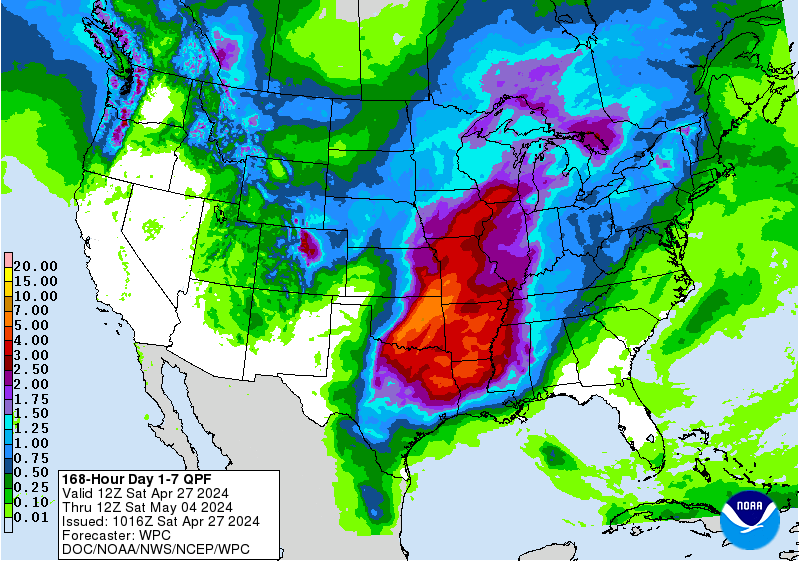
I blew it off the first few days, so I might have missed it close the last few days. But this is the first time I have seen QPF 7 day close to what happens.
http://www.wpc.ncep.noaa.gov/qpf/p168i.gif?1503860122
http://www.wpc.ncep.noaa.gov/qpf/p168i.gif?1503860122
1 likes
-
Frank P
- S2K Supporter
- Posts: 2779
- Joined: Fri Aug 29, 2003 10:52 am
- Location: Biloxi Beach, Ms
- Contact:
Re: ATL: HARVEY - Models
Steve wrote:I blew it off the first few days, so I might have missed it close the last few days. But this is the first time I have seen QPF 7 day close to what happens.
http://www.wpc.ncep.noaa.gov/qpf/p168i.gif?1503860122
I think perhaps the pink areas should be enlarge to include more to the Houston and surrounding areas.. but overall yes..
0 likes
-
1900hurricane

- Category 5

- Posts: 6063
- Age: 34
- Joined: Fri Feb 06, 2015 12:04 pm
- Location: Houston, TX
- Contact:
Re: ATL: HARVEY - Models
2 likes
Contract Meteorologist. TAMU & MSST. Fiercely authentic, one of a kind. We are all given free will, so choose a life meant to be lived. We are the Masters of our own Stories.
Opinions expressed are mine alone.
Follow me on Twitter at @1900hurricane : Read blogs at https://1900hurricane.wordpress.com/
Opinions expressed are mine alone.
Follow me on Twitter at @1900hurricane : Read blogs at https://1900hurricane.wordpress.com/
Re: ATL: HARVEY - Models
CycloneGuru wrote:sphelps8681 wrote:TheStormExpert wrote:Joe Bastardi calling for Harvey to restrengthen to Cat.1 intensity before it's 2nd landfall near the Houston/Galveston area late Tuesday/early Wednesday.
https://twitter.com/BigJoeBastardi/status/901869321554624513
This would not be good for anyone north and east of that.
SRA might have to release water, this is going to be a nightmare more than it already is...
The BRA will have to release water as well pretty soon if we keep getting rain in North Texas. Lakes are already full due to above average rainfall year
0 likes
Personal Forecast Disclaimer:
The posts in this forum are NOT official forecast and should not be used as such. They are just the opinion of the poster and may or may not be backed by sound meteorological data. They are NOT endorsed by any professional institution or storm2k.org. For official information, please refer to the NHC and NWS products.
The posts in this forum are NOT official forecast and should not be used as such. They are just the opinion of the poster and may or may not be backed by sound meteorological data. They are NOT endorsed by any professional institution or storm2k.org. For official information, please refer to the NHC and NWS products.
-
tolakram
- Admin

- Posts: 20179
- Age: 62
- Joined: Sun Aug 27, 2006 8:23 pm
- Location: Florence, KY (name is Mark)
Re: ATL: HARVEY - Models
Models here please, take discussion to the other thread. Let's also not post the Bastardi forecast as it is not a model.
2 likes
M a r k
- - - - -
Join us in chat: Storm2K Chatroom Invite. Android and IOS apps also available.
The posts in this forum are NOT official forecasts and should not be used as such. Posts are NOT endorsed by any professional institution or STORM2K.org. For official information and forecasts, please refer to NHC and NWS products.
-
CycloneGuru
Re: ATL: HARVEY - Models
Sorry I get lost sometimes when there is things posted, i just wanted to respond.
1 likes
Re: ATL: HARVEY - Models
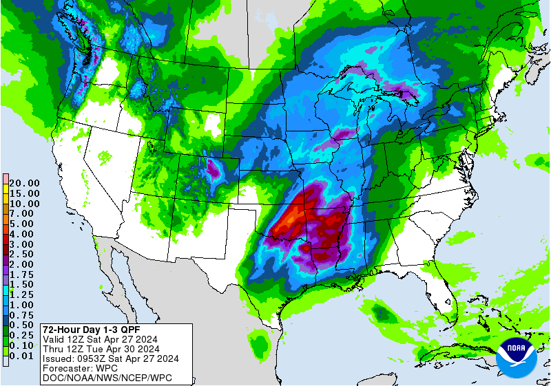
Frank P wrote:Steve wrote:I blew it off the first few days, so I might have missed it close the last few days. But this is the first time I have seen QPF 7 day close to what happens.
http://www.wpc.ncep.noaa.gov/qpf/p168i.gif?1503860122
I think perhaps the pink areas should be enlarge to include more to the Houston and surrounding areas.. but overall yes..
Yeah. We'll have to see how things fill in. I meant to qualify my original post with with the QPF Modeling this year. It's done okay and overestimated/underestimated in years gone by. I don't know if this year has to do with the mid-term GFS's issues of missing out on smaller scale environmental features since it hasn't been hitting the 5 or 7 day totals where it was plainly obvious tropical processes would be in play. It's been that way for every US impact so far. But it does have a pretty strong call on 15+ where it has it in the 3 Day range valid through Wed at 7am.
http://www.wpc.ncep.noaa.gov/qpf/d13_fi ... 3862437913
1 likes
-
stormreader
Re: ATL: HARVEY - Models
BRweather wrote:NAVGEM big shift
https://www.tropicaltidbits.com/analysis/models/navgem/2017082712/navgem_mslp_pcpn_scus_14.png
Bringing SW La more under gun if that would verify. But at this point, I think we have to go with that Euro solution as most likely (pending further observation). Its been calling for Harvey to come back into the coastal waters for a couple of days now. GFS run finally came in to line with it. That more likely scenario is probably worse for Houston and SE Texas. But SW La will probably now still experience a flood event. It won't be on the same magnitude as the Texas event, but nonetheless, very good chance we will see some important flooding in SW LA, TOO.
0 likes
-
ForeverFlorida90s
Re: ATL: HARVEY - Models
https://www.cyclocane.com/harvey-spaghetti-models/
Check out harvey models notice an Eastern shift 1 even brings him to the southern golf interesting week ahead
Check out harvey models notice an Eastern shift 1 even brings him to the southern golf interesting week ahead
1 likes
-
tarheelprogrammer
- S2K Supporter
- Posts: 1793
- Joined: Mon Mar 28, 2016 9:25 pm
- Location: Raleigh, NC area (Garner, NC)
Re: ATL: HARVEY - Models
Anyone know what the UKMET does with Harvey?
0 likes
My posts are not official forecasts. They are just my opinion and may or may not be backed by sound meteorological data. They are NOT endorsed by any professional institution or storm2k.org. For official information, please refer to the NHC and NWS products.
-
bamajammer4eva
- Category 4

- Posts: 907
- Joined: Sun Apr 18, 2010 3:21 am
- Location: Ozark, AL
Re: ATL: HARVEY - Models
ForeverFlorida90s wrote:https://www.cyclocane.com/harvey-spaghetti-models/
Check out harvey models notice an Eastern shift 1 even brings him to the southern golf interesting week ahead
That one model headed straight southeast would be the xtrap which can also be seen in the image below. This is just the current motion and not a model.
tarheelprogrammer wrote:Anyone know what the UKMET does with Harvey?
Blue is the UKMET which I believe did shift to the right. I haven't seen intensity text

2 likes
Who is online
Users browsing this forum: No registered users and 64 guests