095900 2608N 09535W 6966 02734 9503 +171 +107 200003 012 027 001 00
950.3mb this pass. Put it up 3 or 4 MB and we have another 5mb or so pressure drop in the last hour.
ATL: HARVEY - Post-Tropical - Discussion
Moderator: S2k Moderators
-
MaineWeatherNut
- Tropical Storm

- Posts: 225
- Joined: Sun Sep 01, 2013 5:06 pm
Re: ATL: HARVEY - Hurricane - Discussion
1 likes
The content of this post does NOT constitute official forecast and should not be used as such. They are the opinion of the poster and may or may not be backed by sound meteorological data. They are NOT endorsed by any professional institution or Storm2K. For official information, please refer to the local meteorological centers of respective areas.
-
Sciencerocks
- Category 5

- Posts: 10186
- Age: 40
- Joined: Thu Jul 06, 2017 1:51 am
Re: ATL: HARVEY - Hurricane - Discussion
MaineWeatherNut wrote:095900 2608N 09535W 6966 02734 9503 +171 +107 200003 012 027 001 00
950.3mb this pass. Put it up 3 or 4 MB and we have another 5mb or so pressure drop in the last hour.
Its bombing!
Also consider that the smrf for the southwest quad supports cat2 with 2 above 85 knots.
0 likes


Re: ATL: HARVEY - Hurricane - Discussion
No doubt, the eye is tightening up.
Hope this doesn't make a turn to due north.
Hope this doesn't make a turn to due north.
1 likes

Re: ATL: HARVEY - Hurricane - Discussion
Obviously worked out the dry air issues it had last night and the eye is still only 12 miles wide.
With such a small eye at 958 mb's it seems likely Harvey might go through an eye wall replacement cycle before landfall.
That won't help texas much unless it causes dry air intrusion, and with a 48 hour stall over the Texas coast that would still be disastrous.
Wobble watching I think I'm seeing a slight slow down in the northwest motion the last couple hours.
Could be an illusion I'm only looping 5 hours of infrared imagery. That might mean Harvey doesn't track as far inland, the outflow is beginning to expand north on light shear ahead of the trough.
Hope the models start getting more consistent today.
https://weather.msfc.nasa.gov/GOES/goeseasthurrwv.html
1 likes

-
Sciencerocks
- Category 5
- Posts: 10186
- Age: 40
- Joined: Thu Jul 06, 2017 1:51 am
Re: ATL: HARVEY - Hurricane - Discussion
000
URNT12 KNHC 251017
VORTEX DATA MESSAGE AL092017
A. 25/09:56:10Z
B. 26 deg 06 min N
095 deg 35 min W
C. 700 mb 2693 m
D. 86 kt
E. 135 deg 7 nm
F. 232 deg 92 kt
G. 140 deg 10 nm
H. 953 mb
I. 13 C / 3061 m
J. 17 C / 3046 m
K. 10 C / NA
L. CLOSED
M. C11
N. 1234 / 7
O. 0.02 / 0.75 nm
P. AF305 1709A HARVEY OB 12
MAX FL WIND 96 KT 116 / 17 NM 08:46:30Z
CNTR DROPSONDE SFC WIND 155 / 16 KT
MAX FL TEMP 17 C 360 / 2 NM FROM FL CNTR
;
down 5 more millibars. If this keeps up and the winds catch up this could become a cat4 before landfall.
0 likes


-
JtSmarts

- S2K Supporter

- Posts: 1442
- Age: 40
- Joined: Thu Jul 10, 2003 1:29 pm
- Location: Columbia, South Carolina
Re: ATL: HARVEY - Hurricane - Discussion
Charley's TS wind field has expanded from 90 miles to 140 miles. Hurricane force winds still extend 25 miles from the center (Same as Charley 2004).
0 likes
Re: ATL: HARVEY - Hurricane - Discussion
I hope this scares those people on its path that have not evacuated yet to evacuate.

Last edited by NDG on Fri Aug 25, 2017 5:29 am, edited 1 time in total.
1 likes

Re: ATL: HARVEY - Hurricane - Discussion
Not sure if anyone has commented on it yet, but I think it is officially moving more NNW instead of NW.
1 likes
Re: ATL: HARVEY - Hurricane - Discussion
Yet another 20mb drop during the night, the sad part is that it could happen tonight again before landfall.
0 likes
-
USTropics
- Professional-Met

- Posts: 2738
- Joined: Sun Aug 12, 2007 3:45 am
- Location: Florida State University
Re: ATL: HARVEY - Hurricane - Discussion
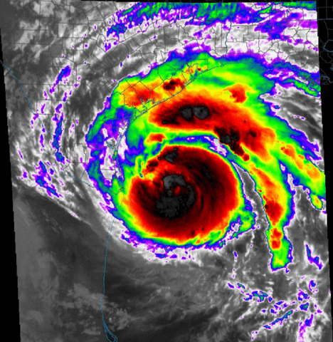
Satellite presentation and radar continues to improve this morning, most likely will be able to see a cleared out pinhole eye and indications of perhaps a stadium effect currently going on with first visible. Below is a saved loop from GOES-16:
Last edited by USTropics on Fri Aug 25, 2017 5:31 am, edited 1 time in total.
1 likes
-
northjaxpro

- S2K Supporter
- Posts: 8900
- Joined: Mon Sep 27, 2010 11:21 am
- Location: Jacksonville, FL
Re: ATL: HARVEY - Hurricane - Discussion
Nimbus wrote:Obviously worked out the dry air issues it had last night and the eye is still only 12 miles wide.
With such a small eye at 958 mb's it seems likely Harvey might go through an eye wall replacement cycle before landfall.
That won't help texas much unless it causes dry air intrusion, and with a 48 hour stall over the Texas coast that would still be disastrous.
Wobble watching I think I'm seeing a slight slow down in the northwest motion the last couple hours.
Could be an illusion I'm only looping 5 hours of infrared imagery. That might mean Harvey doesn't track as far inland, the outflow is beginning to expand north on light shear ahead of the trough.
Hope the models start getting more consistent today.
https://weather.msfc.nasa.gov/GOES/goeseasthurrwv.html
Good morning. This is also what I am watching for to see if Harvey is beginning to slow its forward motion or any drifts northward or northward wobbles.
The eye is smaller this morning, about as tight and tiny as you can have in an intense tropical cyclone. I have no doubts this will be not only a major Cat 3 cyclone, but Harvey I believe will be a Cat r later today. He is not done bombing out just yet.
What an incredible storm! I pray for all in TX and please stay safe and out of harm's way please!!
1 likes
NEVER, EVER SAY NEVER in the tropics and weather in general, and most importantly, with life itself!!
________________________________________________________________________________________
Fay 2008 Beryl 2012 Debby 2012 Colin 2016 Hermine 2016 Julia 2016 Matthew 2016 Irma 2017 Dorian 2019
________________________________________________________________________________________
Fay 2008 Beryl 2012 Debby 2012 Colin 2016 Hermine 2016 Julia 2016 Matthew 2016 Irma 2017 Dorian 2019
-
Aric Dunn
- Category 5
- Posts: 21238
- Age: 43
- Joined: Sun Sep 19, 2004 9:58 pm
- Location: Ready for the Chase.
- Contact:
Re: ATL: HARVEY - Hurricane - Discussion
Slept a long time.. I see it has deepened quite a bit and radar continues to show rapid deepening..
1 likes
Note: If I make a post that is brief. Please refer back to previous posts for the analysis or reasoning. I do not re-write/qoute what my initial post said each time.
If there is nothing before... then just ask
Space & Atmospheric Physicist, Embry-Riddle Aeronautical University,
I believe the sky is falling...
If there is nothing before... then just ask
Space & Atmospheric Physicist, Embry-Riddle Aeronautical University,
I believe the sky is falling...
-
Sciencerocks
- Category 5
- Posts: 10186
- Age: 40
- Joined: Thu Jul 06, 2017 1:51 am
Re: ATL: HARVEY - Hurricane - Discussion
NDG wrote:I hope this scares those people on its path that have not evacuated yet to evacuate.
]
Reminds me of hurricane Charley of 2004. I was 18 years old and doing exactly what I am doing right now and want to sleep for a few hours only to wake up to new recon data of it upgraded to a cat4. Certainly wouldn't surprise.
1 likes
Re: ATL: HARVEY - Hurricane - Discussion
The central and upper TX coast will never be the same, I am afraid after Harvey is gone after next week.
0 likes
-
MississippiWx

- S2K Supporter
- Posts: 1720
- Joined: Sat Aug 14, 2010 1:44 pm
- Location: Hattiesburg, Mississippi
Re: ATL: HARVEY - Hurricane - Discussion
5mb drop in one pass. Harvey may be putting on one last big show before landfall. Obviously, anymore northward movement provides more time over water.
0 likes
This post is not an official forecast and should not be used as such. It is just the opinion of MississippiWx and may or may not be backed by sound meteorological data. It is not endorsed by any professional institution including storm2k.org. For Official Information please refer to the NHC and NWS products.
Re: ATL: HARVEY - Hurricane - Discussion
I had not realized that it was a 5 mb drop in between the last 2 passes, wow!

0 likes
Who is online
Users browsing this forum: No registered users and 46 guests