ATL: IRMA - Post-Tropical - Discussion

Moderator: S2k Moderators

Message
Author
sma10
Category 5
Category 5
Posts: 1710
Joined: Tue Aug 02, 2005 1:13 pm

Re: ATL: IRMA - Hurricane - Discussion

#3901 Postby sma10 » Tue Sep 05, 2017 9:25 am

caneman wrote:
curtadams wrote:
Patrick99 wrote:There was some scuttlebutt on the model thread about models trending east and possibly just missing Florida.....I don't follow the models so closely, any possibility to this?

Models aren't exact. Even the NHC forecast, the best "model" there is, has a five-day forecast error of 250 miles. That's more than the width of the peninsula. So even now, it's quite plausible that Irma and her eyewall could completely miss SFL to either side. Of course anybody there MUST be preparing because a direct strike is quite likely too.


The 5 day margin of era on this storm has been unusually low at I believe 125 mile error so far.


Correct. If the models continue to perform at this good a level, a 125 mile miss is the difference of two degrees of longitude, making a curve up 78W instead of 80W very plausible.
1 likes   

User avatar
sweetpea
S2K Supporter
S2K Supporter
Posts: 858
Age: 58
Joined: Fri Jun 10, 2005 5:49 pm
Location: Sopchoppy, FL

Re: ATL: IRMA - Hurricane - Discussion

#3902 Postby sweetpea » Tue Sep 05, 2017 9:26 am

Just spoke to my dad in Puerto Rico. He said all store shelves are empty. They are saying the island could be without electric for 2-3 months. I am suck a wreck, so worried about all my family in PR. Sending alot of prayers for everyone in the islands.

Definitely will be a long week with also worrying about Florida. We lived there for 20 years and have alot of friends and family there also. Please everyone stay safe in the path of this storm.
Last edited by sweetpea on Tue Sep 05, 2017 9:31 am, edited 1 time in total.
4 likes   

User avatar
Bocadude85
Category 5
Category 5
Posts: 2990
Age: 38
Joined: Mon Apr 18, 2005 2:20 pm
Location: Honolulu,Hi

Re: ATL: IRMA - Hurricane - Discussion

#3903 Postby Bocadude85 » Tue Sep 05, 2017 9:27 am

NJWxHurricane wrote:
MississippiWx wrote:
Hypercane_Kyle wrote:
Sorry, should have specified the global models... yea, the 12z guidance definitely shifted east somewhat. Just shows all possibilities are on the table.


Nothing has shifted east today so far except statistical models and the 6z GFS. Statistical models are basically useless. Watch the main global models come out at 12z for trends.

and the navgem


Not that it really matters but the 6Z HWRF and HMON shifted west. For ever model that shifted east its counter balanced by a model that shifted slightly west, the general area of threat is still Florida for now.
0 likes   

CrazyC83
Professional-Met
Professional-Met
Posts: 34090
Joined: Tue Mar 07, 2006 11:57 pm
Location: Deep South, for the first time!

Re: ATL: IRMA - Main Recon Thread (Data only)

#3904 Postby CrazyC83 » Tue Sep 05, 2017 9:32 am

000
URNT15 KNHC 051429
AF309 0811A IRMA HDOB 33 20170905
141930 1742N 05716W 6973 03136 0059 +080 +079 121066 069 051 005 00
142000 1741N 05718W 6979 03129 0068 +076 //// 126061 064 051 006 01
142030 1740N 05719W 6961 03146 0053 +077 //// 125060 061 049 003 01
142100 1738N 05720W 6970 03136 0048 +081 +077 126062 063 049 003 00
142130 1737N 05722W 6964 03137 0046 +078 +074 125061 063 050 004 00
142200 1736N 05723W 6966 03133 0051 +077 +077 128064 066 048 006 00
142230 1735N 05724W 6969 03125 0030 +086 +077 132066 067 049 004 00
142300 1733N 05726W 6974 03116 //// +076 //// 135065 068 050 005 01
142330 1732N 05727W 6970 03116 0035 +081 //// 136062 066 051 006 01
142400 1731N 05728W 6972 03115 0032 +087 +087 138065 069 051 007 00
142430 1730N 05729W 6976 03106 0027 +090 +090 136068 070 049 010 00
142500 1729N 05731W 6973 03112 0040 +087 +087 139064 067 052 023 03
142530 1727N 05732W 6959 03116 0030 +091 +091 133069 071 054 022 00
142600 1726N 05733W 6972 03109 0039 +087 +087 138070 073 054 026 00
142630 1725N 05734W 6970 03099 0022 +078 +078 139075 077 056 019 00
142700 1724N 05736W 6973 03093 0026 +077 +077 139074 077 055 019 03
142730 1723N 05737W 6968 03098 0015 +085 +085 142080 083 058 012 00
142800 1722N 05738W 6958 03110 0010 +087 +087 136077 084 057 012 00
142830 1720N 05739W 6974 03084 0005 +090 +090 137077 079 057 010 03
142900 1719N 05740W 6975 03083 0001 +088 +088 137078 080 053 018 03
$$
;
0 likes   

User avatar
Bocadude85
Category 5
Category 5
Posts: 2990
Age: 38
Joined: Mon Apr 18, 2005 2:20 pm
Location: Honolulu,Hi

Re: ATL: IRMA - Hurricane - Discussion

#3905 Postby Bocadude85 » Tue Sep 05, 2017 9:35 am

Great discussion by the NWS Miami forecast office

http://forecast.weather.gov/product.php?site=NWS&issuedby=MFL&product=AFD&format=CI&version=1&glossary=0

DISCUSSION...

All eyes continue to closely monitor the progress of Hurricane
Irma. Here are the current Key Messages in relation to South
Florida:

1. Irma is a powerful, dangerous hurricane approaching the
northern Leeward Islands, and the threat to South Florida
continues to increase from late Friday through Monday time frame.

2. South Florida residents and visitors should closely monitor the
progress of Irma. Gather any needed supplies and review your
hurricane action plans. Be prepared to implement that plan later
this week. Continue to monitor the latest forecasts and warnings
from the National Weather Service.

3. Do not focus on the hour to hour changes in the computer
models, nor on the exact center line track in National Hurricane
Center forecasts. These can shift around considerably at this
forecast time range. Instead, focus on reviewing plans and making
preparations in the event watches or warnings are required.


Short term (Today through Wednesday night)...Strong ridge to the
northeast should keep the easterly flow across the region with a
moist tropical environment persisting over South Florida this
week. A fairly weak east flow remains over the region next couple
of days allowing for both the Atlantic and Gulf sea breezes to
develop each afternoon through mid week. Thunderstorms initiate
near the coast and progress inland across the interior and west
Gulf coast in the afternoon hours this week. The main threats from
these convection will be gusty wind, heavy rain, and frequent
lightning. Temperatures will be reaching the mid to low 90s across
the area with dew points in the mid to upper 70s. Heat index
values will once again range between 105 to 108 over the western
interior, near advisory criteria. At this time no advisory has
been issued as conditions remain marginal. The heat index will be
of increasing concern over the next several days, especially
Thursday as tropical moisture combines with light wind flow and
plenty of diurnal heating to create conditions that may warrant
heat advisories for parts of South Florida.

Pattern begins to transition by mid week as a low pressure over the
Great Lakes deepens as far south east of the Mississippi River.
To the east, Hurricane Irma is expected to remain a major
hurricane. The interactions of the frontal boundary associated
with the upper trough and Atlantic high pressure will be the
steering force for Irma. At this point, the environment ahead of
the storm looks to be supportive for it to remain a strong
hurricane.

The chances of South Florida seeing some impacts from Irma later
this week are increasing. It is still too early to forecast where
Irma`s path will go. Models will continue to change and we will have
to watch for emerging trends and what potential impacts could emerge
with Irma. At this point, the best bet for South Florida is to make
a hurricane plan, gather their hurricane kit, and continue to
monitor the progress of Irma as we head through the week.

The extended forecast is almost entirely going to depend on Hurricane
Irma. Continued in this forecast package the mention of conditions
beginning to deteriorate over the Atlantic waters and the coastal
areas with an increase in winds and heavy rainfall as threats into
next weekend.

MARINE...
Showers and thunderstorms will continue around and over the
waters through mid-week. Tropical storm and hurricane conditions
will be possible late in the week, though great uncertainty remains
and all mariners should continue to monitor the forecast and
progress of Irma.
0 likes   

User avatar
Blown Away
S2K Supporter
S2K Supporter
Posts: 10165
Joined: Wed May 26, 2004 6:17 am

Re: ATL: IRMA - Hurricane - Discussion

#3906 Postby Blown Away » Tue Sep 05, 2017 9:36 am

Bocadude85 wrote:
NJWxHurricane wrote:
MississippiWx wrote:
Nothing has shifted east today so far except statistical models and the 6z GFS. Statistical models are basically useless. Watch the main global models come out at 12z for trends.

and the navgem


Not that it really matters but the 6Z HWRF and HMON shifted west. For ever model that shifted east its counter balanced by a model that shifted slightly west, the general area of threat is still Florida for now.


06z HWRF over middle keys...
Last edited by Blown Away on Tue Sep 05, 2017 9:38 am, edited 1 time in total.
0 likes   
Hurricane Eye Experience: David 79, Irene 99, Frances 04, Jeanne 04, Wilma 05… Hurricane Brush Experience: Andrew 92, Erin 95, Floyd 99, Matthew 16, Irma 17, Ian 22, Nicole 22…

KBBOCA
S2K Supporter
S2K Supporter
Posts: 1559
Joined: Fri Sep 05, 2003 5:27 am
Location: Formerly Boca Raton, often West Africa. Currently Charlotte NC

Re: ATL: IRMA - Hurricane - Discussion

#3907 Postby KBBOCA » Tue Sep 05, 2017 9:37 am

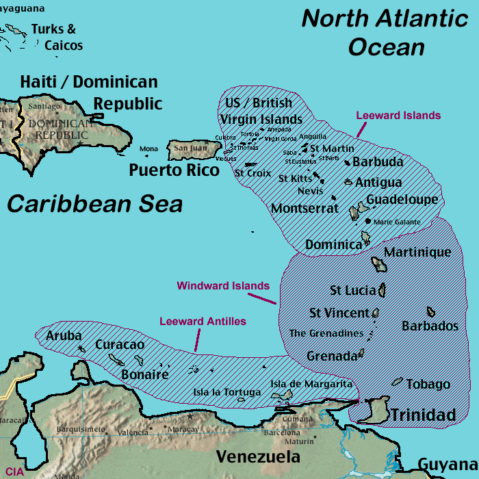
Been using the Closest Point of Approach tool at Storm Carib for some of the islands. So terrifying... Islands such as Anguilla & Barbuda, St. Maarten, St. Barths getting pretty much direct hits if current forecast track verifies:

Obviously any wobbles matter quite a bit to some of the islands that are currently in the 50-90 miles away range. Got to hope and pray for Irma to begin the turn NW. But even if she does, the size of the storm and the proximity to the islands could mean catastrophic impact even from 40-70 miles away.

Not looking yet at Turks & Caicos, Puerto Rico or the DR/Haiti, but there are AT LEAST 8 islands within a "closest point of approach of 50 miles" - 4 of those with a CPA of less than 20 miles.

http://stormcarib.com/closest.cgi

Results for Anguilla (18.2N, 63.08W):
The approximate Closest Point of Approach (CPA) is located near 18.2N, 63.1W or about 1.7 miles(2.8 km) from your location. The estimated time of when the center of the storm will be at that location is in about 1 day, 4 hours and 47 minutes from now (Wednesday, September 6 at 3:00PM AST).


Results for Barbuda (17.63N, 61.78W):
The approximate Closest Point of Approach (CPA) is located near 17.8N, 61.7W or about 10.6 miles (17.1 km) from your location. The estimated time of when the center of the storm will be at that location is in about 22 hours and 44 minutes from now (Wednesday, September 6 at 9:00AM AST).


Results for St.Maarten/St.Martin (18.05N, 63.12W):
The approximate Closest Point of Approach (CPA) is located near 18.2N, 63.1W or about 12.3 miles (19.9 km) from your location. The estimated time of when the center of the storm will be at that location is in about 1 day, 4 hours and 26 minutes from now (Wednesday, September 6 at 2:54PM AST).

Results for St.Barths (17.9N, 62.85W):
The approximate Closest Point of Approach (CPA) is located near 18.1N, 62.8W or about 16.2 miles (26.1 km) from your location. The estimated time of when the center of the storm will be at that location is in about 1 day, 3 hours and 18 minutes from now (Wednesday, September 6 at 1:42PM AST).

Results for St.John (18.35N, 64.73W):
The approximate Closest Point of Approach (CPA) is located near 18.7N, 64.6W or about 28.3 miles (45.5 km) from your location. The estimated time of when the center of the storm will be at that location is in about 1 day, 11 hours and 10 minutes from now (Wednesday, September 6 at 9:36PM AST).

Results for St.Thomas (18.33N, 64.98W):
The approximate Closest Point of Approach (CPA) is located near 18.8N, 64.8W or about 35.3 miles (56.9 km) from your location. The estimated time of when the center of the storm will be at that location is in about 1 day, 12 hours and 1 minute from now (Wednesday, September 6 at 10:30PM AST).

Results for Saba (17.63N, 63.22W):
The approximate Closest Point of Approach (CPA) is located near 18.2N, 63.0W or about 41.8 miles (67.2 km) from your location. The estimated time of when the center of the storm will be at that location is in about 1 day, 4 hours and 20 minutes from now (Wednesday, September 6 at 2:42PM AST).

Results for Antigua (17.12N, 61.78W):
The approximate Closest Point of Approach (CPA) is located near 17.7N, 61.6W or about 43.7 miles (70.4 km) from your location. The estimated time of when the center of the storm will be at that location is in about 22 hours and 3 minutes from now (Wednesday, September 6 at 8:18AM AST).

Results for St.Kitts (17.3N, 62.68W):
The approximate Closest Point of Approach (CPA) is located near 18.0N, 62.4W or about 51.5 miles (82.9 km) from your location. The estimated time of when the center of the storm will be at that location is in about 1 day, 1 hours and 39 minutes from now (Wednesday, September 6 at 12:06PM AST).

Results for Nevis (17.14N, 62.59W):
The approximate Closest Point of Approach (CPA) is located near 18.0N, 62.3W or about 60.0 miles (96.5 km) from your location. The estimated time of when the center of the storm will be at that location is in about 1 day, 1 hours and 9 minutes from now (Wednesday, September 6 at 11:30AM AST).

Results for St.Croix (17.7N, 64.8W):
The approximate Closest Point of Approach (CPA) is located near 18.7N, 64.4W or about 71.8 miles (115.5 km) from your location. The estimated time of when the center of the storm will be at that location is in about 1 day, 10 hours and 29 minutes from now (Wednesday, September 6 at 8:54PM AST).

Results for Montserrat (16.74N, 62.19W):
The approximate Closest Point of Approach (CPA) is located near 17.8N, 61.8W or about 77.3 miles (124.4 km) from your location. The estimated time of when the center of the storm will be at that location is in about 23 hours and 5 minutes from now (Wednesday, September 6 at 9:24AM AST).

Results for Guadeloupe (16.27N, 61.52W):
The approximate Closest Point of Approach (CPA) is located near 17.6N, 61.1W or about 95.1 miles (153.0 km) from your location. The estimated time of when the center of the storm will be at that location is in about 20 hours from now (Wednesday, September 6 at 6:18AM AST).
Image
1 likes   

dukeblue219
S2K Supporter
S2K Supporter
Posts: 538
Joined: Fri Sep 30, 2016 3:52 pm

Re: ATL: IRMA - Hurricane - Discussion

#3908 Postby dukeblue219 » Tue Sep 05, 2017 9:37 am

In the next 20 minutes or so the USAF recon will be making a pass through the N/NE portion of the eyewall, penetrating at roughly the same angle as this morning's 150kt+ SFMR readings.
0 likes   

Airboy
Category 1
Category 1
Posts: 439
Joined: Wed Jul 27, 2011 10:41 am

Re: ATL: IRMA - Hurricane - Discussion

#3909 Postby Airboy » Tue Sep 05, 2017 9:38 am

I have a colleague at my office that has her two children and her ex-boyfriend on vacation in Florida, they landed yesterday, will stay two weeks. Talk about bad luck in timing......
0 likes   
Personal Forecast Disclaimer:
The posts in this forum are NOT official forecast and should not be used as such. They are just the opinion of the poster and may or may not be backed by sound meteorological data. They are NOT endorsed by any professional institution or storm2k.org. For official information, please refer to the NHC and NWS products.

User avatar
doomhaMwx
Category 5
Category 5
Posts: 2456
Age: 26
Joined: Tue Apr 18, 2017 4:01 am
Location: Baguio/Benguet, Philippines
Contact:

Re: ATL: IRMA - Hurricane - Discussion

#3910 Postby doomhaMwx » Tue Sep 05, 2017 9:38 am

1 likes   

User avatar
meriland29
Category 2
Category 2
Posts: 770
Joined: Thu Aug 03, 2017 11:05 am

Re: ATL: IRMA - Hurricane - Discussion

#3911 Postby meriland29 » Tue Sep 05, 2017 9:38 am

I was hoping someone could fill me in on something. I notice the last few frames the color of of the cane has significantly lessened in grays, blacks, etc. Does that mean EWR or slight weakening?

http://www.ssd.noaa.gov/PS/TROP/floater ... imated.gif
Last edited by tolakram on Tue Sep 05, 2017 9:40 am, edited 1 time in total.
Reason: removed IMG tags around direct links.
0 likes   

CrazyC83
Professional-Met
Professional-Met
Posts: 34090
Joined: Tue Mar 07, 2006 11:57 pm
Location: Deep South, for the first time!

Re: ATL: IRMA - Main Recon Thread (Data only)

#3912 Postby CrazyC83 » Tue Sep 05, 2017 9:41 am

000
URNT15 KNHC 051438
AF309 0811A IRMA HDOB 34 20170905
142930 1718N 05742W 6967 03084 9985 +084 +081 136078 080 054 005 00
143000 1717N 05743W 6966 03087 9983 +082 +079 136079 080 059 004 00
143030 1716N 05744W 6965 03082 9986 +079 //// 136082 083 059 005 01
143100 1715N 05745W 6972 03067 9991 +077 //// 135086 088 060 004 01
143130 1713N 05747W 6963 03071 9980 +080 //// 136085 087 062 007 01
143200 1712N 05748W 6971 03055 9976 +081 //// 141088 090 062 007 01
143230 1711N 05749W 6965 03059 9958 +082 //// 144090 092 062 005 01
143300 1710N 05750W 6964 03053 9941 +082 +081 144092 094 064 003 01
143330 1709N 05751W 6963 03045 9937 +083 +080 145095 097 066 006 00
143400 1708N 05752W 6968 03035 9914 +097 +070 146096 097 067 004 00
143430 1707N 05753W 6967 03026 9911 +092 +070 146099 100 067 006 00
143500 1706N 05754W 6965 03025 9902 +096 +066 146104 106 068 006 00
143530 1705N 05755W 6963 03017 9902 +086 +071 143107 109 070 007 00
143600 1704N 05756W 6964 03011 9903 +080 +072 144109 109 071 006 00
143630 1703N 05757W 6966 02997 9888 +083 +071 144112 113 072 006 00
143700 1702N 05758W 6972 02982 9891 +073 +068 144115 117 077 011 00
143730 1701N 05759W 6960 02987 9897 +067 +067 145119 121 078 020 00
143800 1700N 05800W 6969 02964 9888 +070 +070 147120 122 083 022 00
143830 1659N 05801W 6968 02948 9879 +067 +067 145126 127 088 027 00
143900 1658N 05802W 6958 02949 9848 +079 +079 149125 127 092 028 00
$$
;
0 likes   

tolakram
Admin
Admin
Posts: 20035
Age: 62
Joined: Sun Aug 27, 2006 8:23 pm
Location: Florence, KY (name is Mark)

Re: ATL: IRMA - Hurricane - Discussion

#3913 Postby tolakram » Tue Sep 05, 2017 9:41 am

meriland29 wrote:I was hoping someone could fill me in on something. I notice the last few frames the color of of the cane has significantly lessened in grays, blacks, etc. Does that mean EWR or slight weakening?

http://www.ssd.noaa.gov/PS/TROP/floater ... imated.gif


Could be. Recon is n the storm now so we don;t have to guess. ERC's are expected, especially in cat 5 canes.
0 likes   
M a r k
- - - - -
Join us in chat: Storm2K Chatroom Invite. Android and IOS apps also available.

The posts in this forum are NOT official forecasts and should not be used as such. Posts are NOT endorsed by any professional institution or STORM2K.org. For official information and forecasts, please refer to NHC and NWS products.

psyclone
S2K Supporter
S2K Supporter
Posts: 4773
Joined: Wed Aug 24, 2005 9:04 pm
Location: palm harbor fl

Re: ATL: IRMA - Hurricane - Discussion

#3914 Postby psyclone » Tue Sep 05, 2017 9:43 am

Daytime insolation warms the cold cloud tops on infrared imagery.
0 likes   

User avatar
KimmieLa
S2K Supporter
S2K Supporter
Posts: 99
Joined: Fri May 25, 2012 10:38 pm
Location: Baton Rouge, LA

Re: ATL: IRMA - Hurricane - Discussion

#3915 Postby KimmieLa » Tue Sep 05, 2017 9:43 am

SunnyThoughts wrote:Emergency management services in Fla are top notch. By tomorrow morning they will be in high gear ( if not sooner). I'm sure evacuation centers are planning to open as we speak all up and down the peninsula. Stay calm and decide on what you are going to do TODAY, don't wait. If you can afford to leave, go visit family or friends for a week or so in other parts of the country. If you can't afford that, like I said, Fla is top notch when it comes to shelters. Just don't wait until Friday to leave on the highways. My thoughts and prayers go out to all of you further south.


These are words of wisdom. Lots of 'ifs" on the track. Have seen repeatedly that the hurricane force winds are wider than the Florida peninsula. With that said, I truly would make a decision today what I would be doing. I flooded last year, lost everything in my home. I learned possessions are just stuff. Your life is valuable, especially to your family. Nothing is worth putting yourself in grave danger. Heed what your local officials are saying and have your game plan ready to go, sooner rather than later. I am praying for the islands and for Florida. I have no idea which way this storm will head,(model watching will drive you crazy) but I would be prepared for the worse. Like SunnyThoughts said, it might be time to go and visit family, if you can. I am in south La., and I am gonna grab a little extra at the grocery store today, just in case. All I am saying is be prepared. Make your decision and find your peace. Tell friends and family not on this wonderful board what is coming and what to expect so that they can make good choices too. I pray everyone of our S2K family fares well.
0 likes   

User avatar
MississippiWx
S2K Supporter
S2K Supporter
Posts: 1704
Joined: Sat Aug 14, 2010 1:44 pm
Location: Hattiesburg, Mississippi

Re: ATL: IRMA - Hurricane - Discussion

#3916 Postby MississippiWx » Tue Sep 05, 2017 9:43 am

Hypercane_Kyle wrote:Wonder if another EWRC is about to start, cloudtops have warmed considerably since sunrise


Sun naturally warms the cloud tops this time of the day.
2 likes   
This post is not an official forecast and should not be used as such. It is just the opinion of MississippiWx and may or may not be backed by sound meteorological data. It is not endorsed by any professional institution including storm2k.org. For Official Information please refer to the NHC and NWS products.

SunnyThoughts
Category 5
Category 5
Posts: 2263
Joined: Wed Jul 09, 2003 12:42 pm
Location: Pensacola, Florida

Re: ATL: IRMA - Models

#3917 Postby SunnyThoughts » Tue Sep 05, 2017 9:44 am

Gov Rick Scott live briefing...showing on twc right now
0 likes   

KBBOCA
S2K Supporter
S2K Supporter
Posts: 1559
Joined: Fri Sep 05, 2003 5:27 am
Location: Formerly Boca Raton, often West Africa. Currently Charlotte NC

Re: ATL: IRMA - Hurricane - Discussion

#3918 Postby KBBOCA » Tue Sep 05, 2017 9:45 am

EyELeSs1 wrote:
CrazyC83 wrote:Anguilla, Antigua, Barbuda and Anedega look to get the worst of this. Do we have any members on those islands?


Checking in from Antigua. Needless to say, we are watching every wobble from here on.


You are in the thoughts & prayers of many here and elsewhere today. I hope and pray you have somewhere safe to stay. We are watching the wobbles with you and hope Irma will pull north of the islands.
1 likes   

User avatar
chris_fit
Category 5
Category 5
Posts: 3251
Age: 42
Joined: Wed Sep 10, 2003 11:58 pm
Location: Tampa Bay Area, FL

Re: ATL: IRMA - Hurricane - Discussion

#3919 Postby chris_fit » Tue Sep 05, 2017 9:46 am

meriland29 wrote:I was hoping someone could fill me in on something. I notice the last few frames the color of of the cane has significantly lessened in grays, blacks, etc. Does that mean EWR or slight weakening?

http://www.ssd.noaa.gov/PS/TROP/floater ... imated.gif


IRC, this is typical when the sun comes up. Sun makes things warmer, hence cloud tops warm a bit during daylight. I dont think this has anything to do with intensity, just the way the IR works.

Pro Mets - please correct if I'm mistaken.
0 likes   

User avatar
CourierPR
Category 5
Category 5
Posts: 1335
Age: 71
Joined: Tue Aug 31, 2004 7:53 pm
Location: Pompano Beach, Florida

Re: ATL: IRMA - Hurricane - Discussion

#3920 Postby CourierPR » Tue Sep 05, 2017 9:46 am

Meteorologist Bryan Norcross pointed out in tweets this morning that Irma's hurricane force wind field is wider than South Florida and it won't take a direct hit to produce Wilma type winds and storm surge on both coasts.
5 likes   


Return to “2017”

Who is online

Users browsing this forum: No registered users and 8 guests