ATL: IRMA - Post-Tropical - Discussion

Moderator: S2k Moderators

Message
Author
User avatar
flamingosun
S2K Supporter
S2K Supporter
Posts: 198
Joined: Wed Sep 15, 2004 4:51 am
Location: Merritt Island, FL

Re: ATL: IRMA - Hurricane - Discussion

#7621 Postby flamingosun » Fri Sep 08, 2017 7:09 am

From the FloridaDisaster.org website, here is the info on Lake Okeechobee dyke, especially pertinent to those communities along the southern HALF of the lake:

Governor Scott spoke to Col. Jason Kirk with the U.S. Army Corps of Engineers today and the Corps. believes there will be additional impacts from excessive wind pushing some water over the Dike. While they have assured the Governor that the structural integrity of the Dike will not be compromised, Governor Scott has ordered voluntary evacuations beginning immediately in the cities surrounding the southern half of Lake Okeechobee from Lake Port to Canal Point in Hendry, Palm Beach and Glades counties. Mandatory evacuations will be put in place for these communities beginning tomorrow morning. Information regarding transportation and sheltering will be released tomorrow morning. This decision was made due to Governor Scott’s sole focus on life safety as Hurricane Irma approaches Florida. The seven cities affected by these orders are as follows:
South Bay
Lake Harbor
Pahokee
Moore Haven
Clewiston
Belle Glade
Canal Point


Edited to add:
It was dated YESTERDAY, so the "tomorrow" referred to is TODAY
For reference, Glades and Hendry are not on the coast
Last edited by flamingosun on Fri Sep 08, 2017 7:24 am, edited 2 times in total.
0 likes   

User avatar
Hurricane Andrew
S2K Supporter
S2K Supporter
Posts: 1891
Age: 26
Joined: Sun May 23, 2010 2:53 pm
Location: KS

Re: ATL: IRMA - Hurricane - Discussion

#7622 Postby Hurricane Andrew » Fri Sep 08, 2017 7:10 am

GCANE wrote:Another EWRC starting?
Even bigger??

Image

I think that's just intense outer banding, but wouldn't it keep the strength down?
1 likes   

The Enthusiast
NREMT-AEMT, WX nerd

Irene '11, Sandy '12, Irma '17 (SAR)

"Hard to think we were born to live this way..." -Wage War

User avatar
Extratropical94
Professional-Met
Professional-Met
Posts: 3538
Age: 30
Joined: Wed Oct 20, 2010 6:36 am
Location: Hamburg, Germany
Contact:

Re: ATL: IRMA - Main Recon Thread (Data only)

#7623 Postby Extratropical94 » Fri Sep 08, 2017 7:13 am

NOAA thru 28

Image
0 likes   
54° 11' 59'' N, 9° 9' 20'' E
Boomer Sooner!
Go Broncos! Go Cards! Go Niners!
- Daniel

User avatar
Hypercane_Kyle
Category 5
Category 5
Posts: 3354
Joined: Sat Mar 07, 2015 7:58 pm
Location: Cape Canaveral, FL

Re: ATL: IRMA - Hurricane - Discussion

#7624 Postby Hypercane_Kyle » Fri Sep 08, 2017 7:15 am

GCANE wrote:Another EWRC starting?
Even bigger??

Image


I don't think so, not when the first EWRC isn't even complete yet. IMO, those are extremely intense spiral bands.
1 likes   
My posts are my own personal opinion, defer to the National Hurricane Center (NHC) and other NOAA products for decision making during hurricane season.

User avatar
Extratropical94
Professional-Met
Professional-Met
Posts: 3538
Age: 30
Joined: Wed Oct 20, 2010 6:36 am
Location: Hamburg, Germany
Contact:

Re: ATL: IRMA - Main Recon Thread (Data only)

#7625 Postby Extratropical94 » Fri Sep 08, 2017 7:16 am

NOAA 29
URNT15 KWBC 081214
NOAA2 2011A IRMA HDOB 29 20170908
120500 2054N 07325W 7513 02479 9986 +144 +112 201060 061 /// /// 03
120530 2056N 07327W 7509 02479 9983 +142 +121 200064 066 /// /// 03
120600 2057N 07328W 7524 02458 9979 +142 +121 198065 066 /// /// 03
120630 2059N 07330W 7515 02461 9975 +138 +130 197069 072 /// /// 03
120700 2101N 07332W 7529 02438 9974 +136 +125 200070 071 /// /// 03
120730 2102N 07333W 7525 02445 9966 +141 +117 200073 076 /// /// 03
120800 2104N 07335W 7499 02464 9957 +140 +119 200077 078 /// /// 03
120830 2105N 07337W 7498 02461 9952 +134 //// 207074 076 /// /// 05
120900 2107N 07338W 7508 02444 9948 +134 +132 207067 069 /// /// 03
120930 2109N 07340W 7527 02418 9940 +138 +136 202067 069 /// /// 03
121000 2110N 07342W 7511 02431 9931 +139 +138 200071 072 /// /// 03
121030 2112N 07343W 7494 02445 9925 +138 +137 199071 074 /// /// 03
121100 2113N 07345W 7525 02403 9917 +142 +137 197074 074 062 007 03
121130 2115N 07347W 7517 02404 9909 +142 +132 198075 077 059 011 00
121200 2117N 07348W 7518 02395 9903 +137 //// 199077 081 062 011 01
121230 2118N 07350W 7515 02389 9890 +141 +139 199073 075 064 016 00
121300 2120N 07352W 7482 02418 9877 +143 //// 201079 081 067 021 05
121330 2121N 07353W 7489 02397 9863 +142 //// 204081 088 068 024 01
121400 2123N 07355W 7513 02365 9854 +145 //// 212081 083 070 014 01
121430 2124N 07357W 7504 02364 9842 +146 //// 209082 083 072 012 01
0 likes   
54° 11' 59'' N, 9° 9' 20'' E
Boomer Sooner!
Go Broncos! Go Cards! Go Niners!
- Daniel

User avatar
AdamFirst
S2K Supporter
S2K Supporter
Posts: 2491
Age: 36
Joined: Thu Aug 14, 2008 10:54 am
Location: Port Saint Lucie, FL

Re: ATL: IRMA - Hurricane - Discussion

#7626 Postby AdamFirst » Fri Sep 08, 2017 7:20 am

The eye is 40 nautical miles (46 regular miles) wide. I wouldn't take comfort on either side of the coast if the center happens to "miss"
2 likes   
Dolphins Marlins Canes Golden Panthers HEAT
Andrew 1992 - Irene 1999 - Frances 2004 - Jeanne 2004 - Wilma 2005 - Fay 2008 - Isaac 2012 - Matthew 2016 - Irma 2017 - Dorian 2019 - Ian 2022 - Nicole 2022 - Milton 2024

User avatar
GCANE
S2K Supporter
S2K Supporter
Posts: 11500
Joined: Mon Oct 22, 2007 8:03 am

Re: ATL: IRMA - Hurricane - Discussion

#7627 Postby GCANE » Fri Sep 08, 2017 7:21 am

Hurricane Andrew wrote:I think that's just intense outer banding, but wouldn't it keep the strength down?


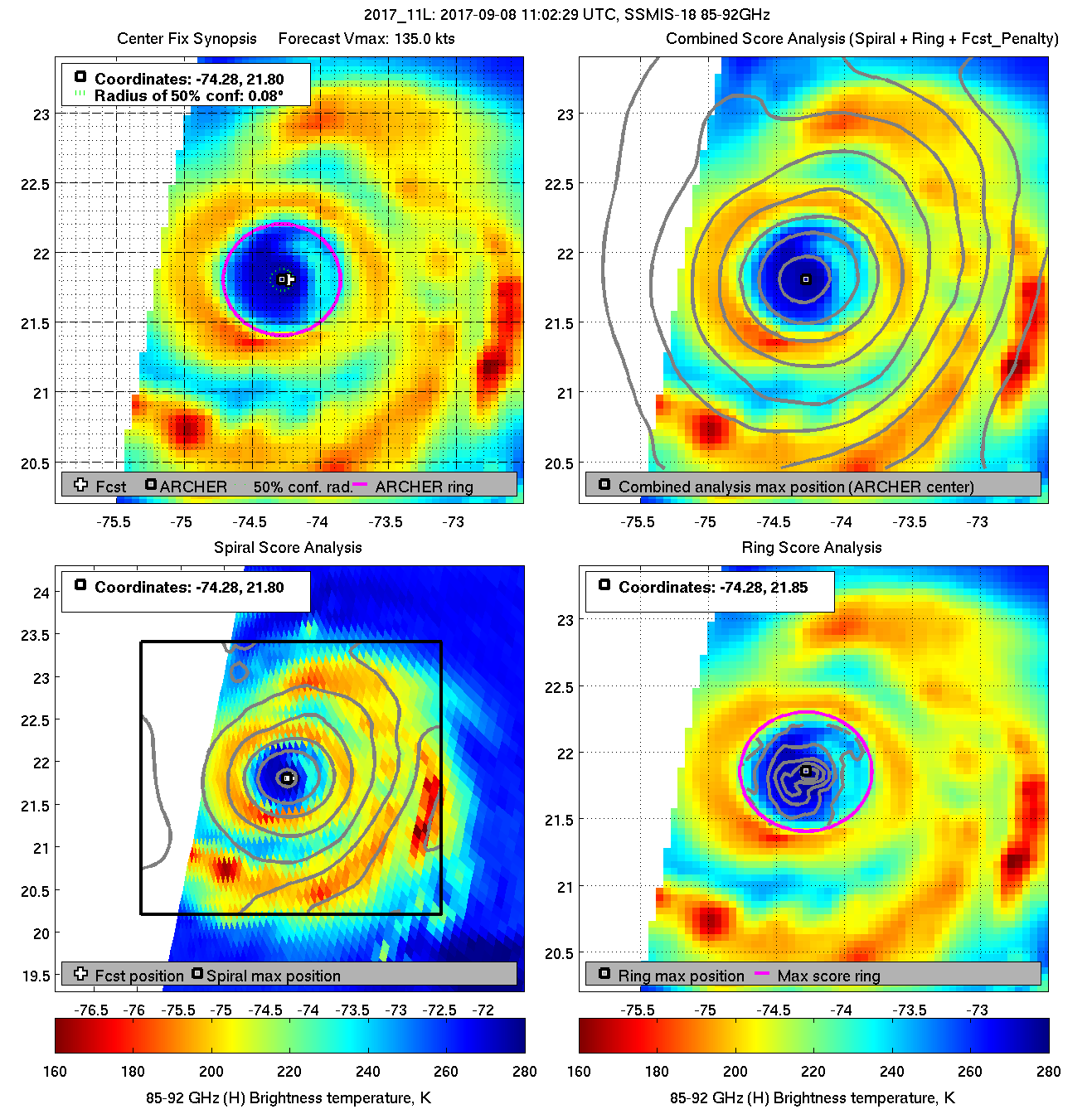
Another Microwave about an hour ago.
Going to be interesting to see how this structure plays out once she gets near the Straits.
A big pump of hot water from the GOM and forecast is for a sudden increase in mid-level moisture.

Image
0 likes   

tolakram
Admin
Admin
Posts: 20012
Age: 62
Joined: Sun Aug 27, 2006 8:23 pm
Location: Florence, KY (name is Mark)

Re: ATL: IRMA - Hurricane - Discussion

#7628 Postby tolakram » Fri Sep 08, 2017 7:23 am

Analyzed wind shear near 0.

Image
0 likes   
M a r k
- - - - -
Join us in chat: Storm2K Chatroom Invite. Android and IOS apps also available.

The posts in this forum are NOT official forecasts and should not be used as such. Posts are NOT endorsed by any professional institution or STORM2K.org. For official information and forecasts, please refer to NHC and NWS products.

kranki
S2K Supporter
S2K Supporter
Posts: 61
Joined: Fri Jul 08, 2005 7:34 am
Location: Port Richey, formerly Summerland Key

Re: ATL: IRMA - Hurricane - Discussion

#7629 Postby kranki » Fri Sep 08, 2017 7:24 am

The new projections look mostly positive to me. The strength in my area, Tampa, should be much less than S. FL. However, I lived in the Keys for 10 years starting in 1998. lol So, the shutters are going on. Other than that, I am pretty ready. The elevation of the house is over 25 feet and I have a big generator with lots of propane. Hurricane George taught me that. So, I think our area will do ok except for probably the low lying areas close to the Gulf that will flood. I am staying as I did in the Keys except I won't have those big hurricane windows to look out and see the storm coming at me. lol Good luck to everyone and stay safe.
1 likes   

User avatar
Extratropical94
Professional-Met
Professional-Met
Posts: 3538
Age: 30
Joined: Wed Oct 20, 2010 6:36 am
Location: Hamburg, Germany
Contact:

Re: ATL: IRMA - Main Recon Thread (Data only)

#7630 Postby Extratropical94 » Fri Sep 08, 2017 7:26 am

NOAA 30
URNT15 KWBC 081224
NOAA2 2011A IRMA HDOB 30 20170908
121500 2126N 07358W 7514 02345 9832 +148 +148 206085 088 071 012 00
121530 2127N 07400W 7529 02321 9829 +143 //// 200088 090 069 013 01
121600 2128N 07402W 7509 02334 9820 +139 //// 194094 095 072 010 01
121630 2130N 07404W 7497 02330 9799 +142 +138 193098 100 079 008 00
121700 2131N 07406W 7499 02306 9780 +141 +138 194103 105 081 008 00
121730 2133N 07408W 7511 02273 9755 +143 +142 193109 111 083 011 00
121800 2134N 07410W 7513 02244 9725 +144 +140 191116 119 090 012 00
121830 2136N 07411W 7519 02207 9693 +143 +143 193123 124 096 016 00
121900 2137N 07413W 7500 02188 9646 +146 //// 194128 130 104 036 01
121930 2139N 07415W 7509 02141 9594 +156 //// 198127 132 109 038 01
122000 2140N 07417W 7493 02124 9545 +165 //// 200109 113 114 023 01
122030 2142N 07419W 7517 02064 9511 +172 //// 190108 111 113 009 01
122100 2143N 07421W 7530 02016 9471 +181 +174 185105 110 109 003 00
122130 2145N 07423W 7513 02001 9430 +185 +177 181103 105 098 004 00
122200 2147N 07425W 7482 01997 9380 +190 //// 175097 100 091 006 01
122230 2148N 07427W 7538 01894 9342 +196 +193 170080 088 092 003 03
122300 2148N 07429W 7490 01931 9316 +198 +190 168063 068 067 005 03
122330 2147N 07431W 7482 01927 9304 +194 //// 164049 053 048 002 05
122400 2147N 07434W 7499 01896 9291 +194 //// 168039 042 039 002 01
122430 2146N 07436W 7525 01858 9281 +200 +193 156028 032 032 002 03
0 likes   
54° 11' 59'' N, 9° 9' 20'' E
Boomer Sooner!
Go Broncos! Go Cards! Go Niners!
- Daniel

shawn6304
Tropical Low
Tropical Low
Posts: 39
Joined: Tue Oct 04, 2016 2:14 pm
Location: Deerfield Beach Florida

Re: ATL: IRMA - Hurricane - Discussion

#7631 Postby shawn6304 » Fri Sep 08, 2017 7:26 am

wxman57 wrote:
ronjon wrote:
wxman57 wrote:
If Irma tracks up the central FL Peninsula then you would see tides below normal there with a strong northerly wind. Very good GFS/EC agreement now. Eyewall may miss Miami/Palm Beach to the west and Ft. Myers to the east.


Yes wxman IF it can thread the needle with the eyewall but one wobble west or east and well we all know what that means.


Yeah, it would mean stronger northerly wind on the west coast, but still no surge, which was the original question. Irma would have to pass the Keys and come up from the south into Ft. Myers like Charlie. That would be very bad for the SW Peninsula. Can't rule that out, but it's looking like Irma will stay to the east.


Won't the SW coast get surge as the storm passes to the north? Almost like a reverse surge?
1 likes   

Michele B
S2K Supporter
S2K Supporter
Posts: 1114
Joined: Thu Aug 25, 2016 8:08 am
Location: SWFL

Re: ATL: IRMA - Hurricane - Discussion

#7632 Postby Michele B » Fri Sep 08, 2017 7:27 am

M3gaMatch wrote:
Hurricane Andrew wrote:EWRC, which lasted about 24hrs, is now done; once she re-tightens, I expect her to begin deepening again. Just my opinion, please refer to the NHC for official forecasts, products, etc. They've been doing a great job.

http://tropic.ssec.wisc.edu/real-time/m ... splay.html


That is a great animation, thanks.


That really IS a great animation!

It shows the whole EWRC and some dry air trying to intrude, but she seems able to fight it off!

AWESOME (in one way....)
0 likes   
Cleo - 1964, Betsy - 1965, David - 1979, Andrew - 1992, Charlie (Francis, Ivan, Jeanne) - 2004, Irma - 2017, Ian - 2022

User avatar
Hypercane_Kyle
Category 5
Category 5
Posts: 3354
Joined: Sat Mar 07, 2015 7:58 pm
Location: Cape Canaveral, FL

Re: ATL: IRMA - Hurricane - Discussion

#7633 Postby Hypercane_Kyle » Fri Sep 08, 2017 7:32 am

Michele B wrote:
M3gaMatch wrote:
Hurricane Andrew wrote:EWRC, which lasted about 24hrs, is now done; once she re-tightens, I expect her to begin deepening again. Just my opinion, please refer to the NHC for official forecasts, products, etc. They've been doing a great job.

http://tropic.ssec.wisc.edu/real-time/m ... splay.html


That is a great animation, thanks.


That really IS a great animation!

It shows the whole EWRC and some dry air trying to intrude, but she seems able to fight it off!

AWESOME (in one way....)


Not seeing anything that looks like dry air intrusion, what am I missing?
0 likes   
My posts are my own personal opinion, defer to the National Hurricane Center (NHC) and other NOAA products for decision making during hurricane season.

User avatar
Phoenix78
Tropical Low
Tropical Low
Posts: 41
Joined: Tue Jul 22, 2003 12:52 pm
Location: Vero Beach, Florida

Re: ATL: IRMA - Hurricane - Discussion

#7634 Postby Phoenix78 » Fri Sep 08, 2017 7:33 am

Folks, I'm looking at the hourly weather forecast graphs on the NWS office website. My location in Vero Beach is forecasted on this graph to experience sustained winds of 65mph, with 80mph gusts Sunday night! Miami, West Palm and Lakeland also show much lower windspeeds than yesterday!! What's going on???? Are these graphs accurate????
0 likes   

tolakram
Admin
Admin
Posts: 20012
Age: 62
Joined: Sun Aug 27, 2006 8:23 pm
Location: Florence, KY (name is Mark)

Re: ATL: IRMA - Hurricane - Discussion

#7635 Postby tolakram » Fri Sep 08, 2017 7:33 am

0 likes   
M a r k
- - - - -
Join us in chat: Storm2K Chatroom Invite. Android and IOS apps also available.

The posts in this forum are NOT official forecasts and should not be used as such. Posts are NOT endorsed by any professional institution or STORM2K.org. For official information and forecasts, please refer to NHC and NWS products.

User avatar
Extratropical94
Professional-Met
Professional-Met
Posts: 3538
Age: 30
Joined: Wed Oct 20, 2010 6:36 am
Location: Hamburg, Germany
Contact:

Re: ATL: IRMA - Hurricane - Discussion

#7636 Postby Extratropical94 » Fri Sep 08, 2017 7:33 am

11L IRMA 170908 1200 21.8N 74.7W ATL 130 927
0 likes   
54° 11' 59'' N, 9° 9' 20'' E
Boomer Sooner!
Go Broncos! Go Cards! Go Niners!
- Daniel

Michele B
S2K Supporter
S2K Supporter
Posts: 1114
Joined: Thu Aug 25, 2016 8:08 am
Location: SWFL

Re: ATL: IRMA - Hurricane - Discussion

#7637 Postby Michele B » Fri Sep 08, 2017 7:34 am

Hypercane_Kyle wrote:
Michele B wrote:
M3gaMatch wrote:
That is a great animation, thanks.


That really IS a great animation!

It shows the whole EWRC and some dry air trying to intrude, but she seems able to fight it off!

AWESOME (in one way....)


Not seeing anything that looks like dry air intrusion, what am I missing?


Is the blue on the east side not dry air intrusion?
0 likes   
Cleo - 1964, Betsy - 1965, David - 1979, Andrew - 1992, Charlie (Francis, Ivan, Jeanne) - 2004, Irma - 2017, Ian - 2022

PandaCitrus
Category 1
Category 1
Posts: 424
Joined: Mon Sep 04, 2017 2:44 pm

Re: ATL: IRMA - Hurricane - Discussion

#7638 Postby PandaCitrus » Fri Sep 08, 2017 7:35 am

I don't think southeast Florida is off the hook with a west track. Not in the least. A 45 mile wide eye hitting where the euro says it will would put the northeast quadrant and the eyewall over metro south Florida.

That could be a worse damage run than the GFS. At least with HE'S south Florida would get 3 to 4 hours of eye and calm winds.
1 likes   

tolakram
Admin
Admin
Posts: 20012
Age: 62
Joined: Sun Aug 27, 2006 8:23 pm
Location: Florence, KY (name is Mark)

Re: ATL: IRMA - Hurricane - Discussion

#7639 Postby tolakram » Fri Sep 08, 2017 7:35 am

Phoenix78 wrote:Folks, I'm looking at the hourly weather forecast graphs on the NWS office website. My location in Vero Beach is forecasted on this graph to experience sustained winds of 65mph, with 80mph gusts Sunday night! Miami, West Palm and Lakeland also show much lower windspeeds than yesterday!! What's going on???? Are these graphs accurate????


Track drifted a little bit west. If you are in the cone then expectations are landfall can be anywhere in that cone. Track will drift left and right up until landfall. When wind estimates are produced that are based on that track so they will go up and down. Expect the worst, hope for the best.
1 likes   
M a r k
- - - - -
Join us in chat: Storm2K Chatroom Invite. Android and IOS apps also available.

The posts in this forum are NOT official forecasts and should not be used as such. Posts are NOT endorsed by any professional institution or STORM2K.org. For official information and forecasts, please refer to NHC and NWS products.

User avatar
Extratropical94
Professional-Met
Professional-Met
Posts: 3538
Age: 30
Joined: Wed Oct 20, 2010 6:36 am
Location: Hamburg, Germany
Contact:

Re: ATL: IRMA - Main Recon Thread (Data only)

#7640 Postby Extratropical94 » Fri Sep 08, 2017 7:37 am

NOAA 31
URNT15 KWBC 081234
NOAA2 2011A IRMA HDOB 31 20170908
122500 2145N 07438W 7531 01838 9276 +200 +195 149018 021 023 001 00
122530 2144N 07440W 7499 01881 9274 +200 +193 183005 010 023 001 00
122600 2144N 07442W 7525 01856 9275 +201 +193 299008 012 020 001 03
122630 2145N 07444W 7561 01813 9276 +204 +194 359013 015 019 002 00
122700 2146N 07445W 7471 01919 9278 +202 +187 017021 027 021 003 00
122730 2148N 07447W 7513 01879 9286 +203 +186 033032 035 033 003 00
122800 2149N 07449W 7504 01897 9297 +200 +194 030039 042 036 002 00
122830 2150N 07450W 7515 01895 9306 +206 +190 032049 055 055 004 00
122900 2151N 07452W 7511 01918 9327 +197 +190 034071 082 073 013 00
122930 2153N 07453W 7528 01927 9364 +185 //// 035096 100 085 019 01
123000 2154N 07455W 7512 01983 9406 +181 +174 036102 102 097 009 00
123030 2155N 07456W 7513 02010 9444 +174 +169 040105 109 104 005 00
123100 2156N 07458W 7546 01997 9471 +174 +173 050108 115 109 003 00
123130 2158N 07500W 7534 02042 9511 +168 //// 055128 136 110 013 01
123200 2159N 07501W 7359 02281 9569 +140 //// 040144 148 112 034 05
123230 2200N 07503W 7338 02341 9605 +134 //// 037140 144 107 046 01
123300 2201N 07504W 7499 02185 9641 +143 +140 041136 138 100 035 00
123330 2202N 07505W 7525 02190 9669 +152 +143 044132 134 091 022 00
123400 2203N 07507W 7511 02228 9697 +149 +132 046125 128 087 012 00
123430 2205N 07508W 7509 02248 9720 +149 +131 049121 122 083 010 00
0 likes   
54° 11' 59'' N, 9° 9' 20'' E
Boomer Sooner!
Go Broncos! Go Cards! Go Niners!
- Daniel


Return to “2017”

Who is online

Users browsing this forum: No registered users and 6 guests