ATL: IRMA - Post-Tropical - Discussion

Moderator: S2k Moderators

Message
Author
Michele B
S2K Supporter
S2K Supporter
Posts: 1114
Joined: Thu Aug 25, 2016 8:08 am
Location: SWFL

Re: ATL: IRMA - Hurricane - Discussion

#7641 Postby Michele B » Fri Sep 08, 2017 7:38 am

Phoenix78 wrote:Folks, I'm looking at the hourly weather forecast graphs on the NWS office website. My location in Vero Beach is forecasted on this graph to experience sustained winds of 65mph, with 80mph gusts Sunday night! Miami, West Palm and Lakeland also show much lower windspeeds than yesterday!! What's going on???? Are these graphs accurate????


This is a very large storm, many miles across with a large eye, which just enlarged again after another ERC. This means even the hurricane force wind field will cover more miles.

I wouldn't doubt the reports.
0 likes   
Cleo - 1964, Betsy - 1965, David - 1979, Andrew - 1992, Charlie (Francis, Ivan, Jeanne) - 2004, Irma - 2017, Ian - 2022

tolakram
Admin
Admin
Posts: 20012
Age: 62
Joined: Sun Aug 27, 2006 8:23 pm
Location: Florence, KY (name is Mark)

Re: ATL: IRMA - Hurricane - Discussion

#7642 Postby tolakram » Fri Sep 08, 2017 7:38 am

0 likes   
M a r k
- - - - -
Join us in chat: Storm2K Chatroom Invite. Android and IOS apps also available.

The posts in this forum are NOT official forecasts and should not be used as such. Posts are NOT endorsed by any professional institution or STORM2K.org. For official information and forecasts, please refer to NHC and NWS products.

User avatar
NDG
S2K Supporter
S2K Supporter
Posts: 15446
Joined: Sun Jul 09, 2006 10:14 pm
Location: Orlando, FL

Re: ATL: IRMA - Hurricane - Discussion

#7643 Postby NDG » Fri Sep 08, 2017 7:39 am

wxman57 wrote:
Myersgirl wrote:This trend is definitely not good for us on the South west coast. Worried about the surge coming up the river here in Fort Myers. It didn't rise here for Charlie or Wilma, but this might be different.


If Irma tracks up the central FL Peninsula then you would see tides below normal there with a strong northerly wind. Very good GFS/EC agreement now. Eyewall may miss Miami/Palm Beach to the west and Ft. Myers to the east.


I respectfully disagree with you, there should be some storm surge over SW FL as Irma tracks north and the winds turn onshore from the west and southwest, definitely not as high as the Keys and SE FL & NE FL .
GFS derived model shows some storm surge over SW FL.

Image

http://mag.ncep.noaa.gov/model-guidance ... oop_end=-1
Last edited by tolakram on Fri Sep 08, 2017 7:43 am, edited 1 time in total.
Reason: typo, I hope :)
1 likes   

User avatar
Bunkertor
Category 5
Category 5
Posts: 3397
Joined: Tue May 09, 2006 3:48 pm

Re: ATL: IRMA - Hurricane - Discussion

#7644 Postby Bunkertor » Fri Sep 08, 2017 7:42 am

0 likes   

AutoPenalti
Category 5
Category 5
Posts: 4030
Age: 29
Joined: Mon Aug 17, 2015 4:16 pm
Location: Ft. Lauderdale, Florida

Re: ATL: IRMA - Hurricane - Discussion

#7645 Postby AutoPenalti » Fri Sep 08, 2017 7:43 am

I don't think that's a dry air intrusion...
1 likes   
The posts in this forum are NOT official forecasts and should not be used as such. They are just the opinion of the poster and may or may not be backed by sound meteorological data. They are NOT endorsed by any professional institution or STORM2K. For official information, please refer to products from the NHC and NWS.


Model Runs Cheat Sheet:
GFS (5:30 AM/PM, 11:30 AM/PM)
HWRF, GFDL, UKMET, NAVGEM (6:30-8:00 AM/PM, 12:30-2:00 AM/PM)
ECMWF (1:45 AM/PM)

TCVN
is a weighted averaged

shawn6304
Tropical Low
Tropical Low
Posts: 39
Joined: Tue Oct 04, 2016 2:14 pm
Location: Deerfield Beach Florida

Re: ATL: IRMA - Hurricane - Discussion

#7646 Postby shawn6304 » Fri Sep 08, 2017 7:45 am

I guess it is good and means people are getting prepared but i thought this board would be hopping today and its really kind of a ghost town in here.
0 likes   

Michele B
S2K Supporter
S2K Supporter
Posts: 1114
Joined: Thu Aug 25, 2016 8:08 am
Location: SWFL

Re: ATL: IRMA - Hurricane - Discussion

#7647 Postby Michele B » Fri Sep 08, 2017 7:47 am

AutoPenalti wrote:I don't think that's a dry air intrusion...


OK, sorry.

I guess the saying: "A little knowledge is a dangerous thing" rings true!
0 likes   
Cleo - 1964, Betsy - 1965, David - 1979, Andrew - 1992, Charlie (Francis, Ivan, Jeanne) - 2004, Irma - 2017, Ian - 2022

Snowman67
Category 2
Category 2
Posts: 633
Joined: Thu Dec 31, 2009 12:44 pm
Location: Tomball, TX

Re: ATL: IRMA - Hurricane - Discussion

#7648 Postby Snowman67 » Fri Sep 08, 2017 7:48 am

No one should let their guard down just because the peak winds are not as strong. I went through Hurricane Ike. It was a category 2 when it hit the Texas coast with winds of 110 mph and did massive amounts of damage. You have to look at the size of the overall storm. Ike was a very large storm and the hurricane force winds were spread over a large area. Irma is also a large storm and getting larger. Everyone stay safe.
1 likes   
Any forecast I make is based on my opinion only. Please refer to the NWS or NHC for official forecasts.

User avatar
Extratropical94
Professional-Met
Professional-Met
Posts: 3538
Age: 30
Joined: Wed Oct 20, 2010 6:36 am
Location: Hamburg, Germany
Contact:

Re: ATL: IRMA - Main Recon Thread (Data only)

#7649 Postby Extratropical94 » Fri Sep 08, 2017 7:48 am

NOAA 32
URNT15 KWBC 081244
NOAA2 2011A IRMA HDOB 32 20170908
123500 2206N 07510W 7518 02255 9742 +144 //// 051118 119 083 008 01
123530 2207N 07512W 7528 02265 9767 +140 //// 052116 117 080 007 01
123600 2209N 07513W 7513 02303 9788 +141 +137 051109 111 076 003 00
123630 2210N 07515W 7512 02317 9804 +144 +128 052104 106 072 004 00
123700 2211N 07517W 7509 02335 9818 +142 +128 051101 102 074 004 00
123730 2213N 07518W 7516 02335 9829 +144 +137 052100 101 070 007 00
123800 2214N 07520W 7510 02353 9841 +142 +141 052098 099 066 011 00
123830 2215N 07522W 7517 02354 9850 +141 //// 053095 098 066 012 01
123900 2217N 07523W 7497 02383 9857 +142 //// 055090 097 065 013 01
123930 2218N 07525W 7530 02356 9866 +145 +143 054091 091 065 013 00
124000 2219N 07527W 7518 02375 9874 +146 +142 058090 095 064 009 00
124030 2221N 07529W 7517 02384 9883 +144 +142 060090 094 065 006 00
124100 2222N 07530W 7523 02385 9885 +150 +136 061084 085 064 005 00
124130 2224N 07532W 7506 02412 9896 +146 +136 060087 087 061 005 00
124200 2225N 07534W 7498 02425 9905 +143 +141 060089 090 059 008 00
124230 2226N 07536W 7511 02419 9915 +141 +141 060091 092 057 008 00
124300 2228N 07538W 7517 02416 9925 +138 //// 060093 095 057 008 01
124330 2229N 07539W 7503 02438 9936 +136 //// 057090 092 054 010 01
124400 2231N 07541W 7518 02430 9943 +136 //// 055087 089 053 014 05
124430 2232N 07543W 7512 02445 9949 +136 //// 056087 088 051 014 01
0 likes   
54° 11' 59'' N, 9° 9' 20'' E
Boomer Sooner!
Go Broncos! Go Cards! Go Niners!
- Daniel

User avatar
Phoenix78
Tropical Low
Tropical Low
Posts: 41
Joined: Tue Jul 22, 2003 12:52 pm
Location: Vero Beach, Florida

Re: ATL: IRMA - Hurricane - Discussion

#7650 Postby Phoenix78 » Fri Sep 08, 2017 7:48 am

Phoenix78 wrote:
Folks, I'm looking at the hourly weather forecast graphs on the NWS office website. My location in Vero Beach is forecasted on this graph to experience sustained winds of 65mph, with 80mph gusts Sunday night! Miami, West Palm and Lakeland also show much lower windspeeds than yesterday!! What's going on???? Are these graphs accurate????

Track drifted a little bit west. If you are in the cone then expectations are landfall can be anywhere in that cone. Track will drift left and right up until landfall. When wind estimates are produced that are based on that track so they will go up and down. Expect the worst, hope for the best.


I'm not sure how to cut and paste here, but my point is yesterday we were looking at sustained winds of 120mph, with gusts to 140 - now the forecast calls for winds of 65mph with gusts to 80!!!! Could this possibly be correct???
0 likes   

kaykayjs
Tropical Low
Tropical Low
Posts: 11
Joined: Mon Sep 04, 2017 4:38 pm
Location: Orlando

Re: ATL: IRMA - Hurricane - Discussion

#7651 Postby kaykayjs » Fri Sep 08, 2017 7:49 am

Orlando here. Looks like on the current track we will get the right side (eye wall? not sure since the eye wall is so huge). My dad is in a mobile home in Kissimmee and being stubborn. Hoping to get him to leave. Praying we only get a 2 here because I'm not sure his place will hold up.
0 likes   
Opal '95, Ivan '04, Katrina '05, Matthew '16, Irma '17

tolakram
Admin
Admin
Posts: 20012
Age: 62
Joined: Sun Aug 27, 2006 8:23 pm
Location: Florence, KY (name is Mark)

Re: ATL: IRMA - Hurricane - Discussion

#7652 Postby tolakram » Fri Sep 08, 2017 7:50 am

 https://twitter.com/NHC_Surge/status/906125853997838336


NHC_Surge ✔ @NHC_Surge
There is growing concern for significant storm surge flooding over SW FL, see latest information here: http://www.nhc.noaa.gov/refresh/graphics_at1+shtml/093751.shtml?inundation#contents
8:03 AM - Sep 8, 2017
0 likes   
M a r k
- - - - -
Join us in chat: Storm2K Chatroom Invite. Android and IOS apps also available.

The posts in this forum are NOT official forecasts and should not be used as such. Posts are NOT endorsed by any professional institution or STORM2K.org. For official information and forecasts, please refer to NHC and NWS products.

User avatar
Tireman4
S2K Supporter
S2K Supporter
Posts: 5853
Age: 59
Joined: Fri Jun 30, 2006 1:08 pm
Location: Humble, Texas
Contact:

Re: ATL: IRMA - Hurricane - Discussion

#7653 Postby Tireman4 » Fri Sep 08, 2017 7:53 am

For the newbies, make sure to put in your hometown or where you are. That will help the pro and amateur mets help with your questions. Thanks.
1 likes   

SootyTern
S2K Supporter
S2K Supporter
Posts: 316
Age: 56
Joined: Sun Sep 05, 2004 5:09 pm
Location: NYC (formerly Homestead, FL)

Re: ATL: IRMA - Hurricane - Discussion

#7654 Postby SootyTern » Fri Sep 08, 2017 7:54 am

GCANE wrote:
Hurricane Andrew wrote:I think that's just intense outer banding, but wouldn't it keep the strength down?


Another Microwave about an hour ago.
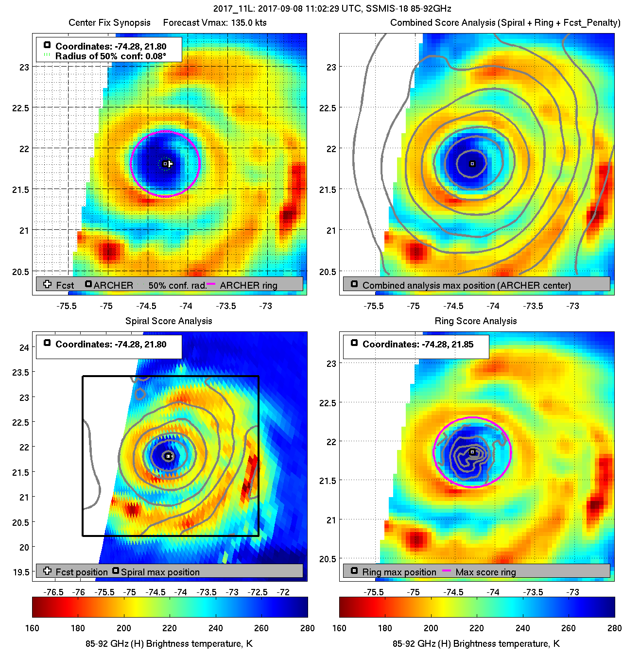
Going to be interesting to see how this structure plays out once she gets near the Straits.
A big pump of hot water from the GOM and forecast is for a sudden increase in mid-level moisture.

Image


GCANE, what do you think the probabilities are of re-intensification to Cat 5 before landfall if she keeps clear of Cuba?
0 likes   
Disclaimer:
The posts in this forum are NOT official forecasts and should not be used as such. For official information, please refer to the NHC and NWS products.

Gulf Coast: Opal '95 Georges '98 / So Fla: Katrina '05 Wilma '05 Irma '17

norva
Tropical Low
Tropical Low
Posts: 44
Joined: Fri Sep 01, 2017 10:41 am

Re: ATL: IRMA - Hurricane - Discussion

#7655 Postby norva » Fri Sep 08, 2017 7:55 am

Any wind and gust forecasts for your town are to be taken with a bit of a grain of salt, the track can and will shift, intensity at landfall and how quickly it will weaken are all up in the air. Look at it as just one possibility and maybe a sense of range but keep in mind until it's happening these forecasts are just a possibility.
2 likes   

User avatar
Extratropical94
Professional-Met
Professional-Met
Posts: 3538
Age: 30
Joined: Wed Oct 20, 2010 6:36 am
Location: Hamburg, Germany
Contact:

Re: ATL: IRMA - Main Recon Thread (Data only)

#7656 Postby Extratropical94 » Fri Sep 08, 2017 7:58 am

NOAA SE EYEWALL DROP - 120 kt sfc
UZNT13 KWBC 081248
XXAA 58128 99217 70743 08014 99958 26006 14120 00879 ///// /////
92312 23803 16139 85053 21410 18640 88999 77999
31313 09608 81219
61616 NOAA2 2011A IRMA OB 15
62626 EYEWALL 135 MBL WND 16133 AEV 33304 DLM WND 18133 957750 WL
150 15129 085 REL 2165N07426W 121928 SPG 2177N07426W 122229 =
XXBB 58128 99217 70743 08014 00958 26006 11850 21410 22750 15800
21212 00958 14120 11954 14629 22946 15132 33939 15625 44932 15635
55925 16139 66919 16636 77915 16645 88907 17139 99899 17645 11892
18138 22884 18138 33865 18149 44850 18640 55786 19130 66777 19642
77750 19627
31313 09608 81219
61616 NOAA2 2011A IRMA OB 15
62626 EYEWALL 135 MBL WND 16133 AEV 33304 DLM WND 18133 957750 WL
150 15129 085 REL 2165N07426W 121928 SPG 2177N07426W 122229 =
0 likes   
54° 11' 59'' N, 9° 9' 20'' E
Boomer Sooner!
Go Broncos! Go Cards! Go Niners!
- Daniel

znel52

Re: ATL: IRMA - Hurricane - Discussion

#7657 Postby znel52 » Fri Sep 08, 2017 7:59 am

Getting close to Cat 5 again it appears

Flight Level Wind (30 sec. Avg.)

From 40° at 144 knots
(From the NE at ~ 165.7 mph

Peak (10 sec. Avg.) Flight Level Wind

148 knots
(~ 170.3 mph)
0 likes   

User avatar
Extratropical94
Professional-Met
Professional-Met
Posts: 3538
Age: 30
Joined: Wed Oct 20, 2010 6:36 am
Location: Hamburg, Germany
Contact:

Re: ATL: IRMA - Hurricane - Discussion

#7658 Postby Extratropical94 » Fri Sep 08, 2017 8:01 am

znel52 wrote:Back to Cat 5?

Flight Level Wind (30 sec. Avg.)

From 40° at 144 knots
(From the NE at ~ 165.7 mph

Peak (10 sec. Avg.) Flight Level Wind

148 knots
(~ 170.3 mph)


Unlikely. Surface estimates are near 110-115 knots, and a dropsonde just measured 120 in the SE eyewall. So Cat 4 is a good call for now.
0 likes   
54° 11' 59'' N, 9° 9' 20'' E
Boomer Sooner!
Go Broncos! Go Cards! Go Niners!
- Daniel

User avatar
SouthDadeFish
Professional-Met
Professional-Met
Posts: 2835
Joined: Thu Sep 23, 2010 2:54 pm
Location: Miami, FL
Contact:

Re: ATL: IRMA - Hurricane - Discussion

#7659 Postby SouthDadeFish » Fri Sep 08, 2017 8:01 am

znel52 wrote:Back to Cat 5?

Flight Level Wind (30 sec. Avg.)

From 40° at 144 knots
(From the NE at ~ 165.7 mph

Peak (10 sec. Avg.) Flight Level Wind

148 knots
(~ 170.3 mph)


Those are flight-level winds. With the reduction factor, those winds at the surface would be around 125-130 kt. SFMR isn't measuring any surface winds anywhere near category-5 right now. In fact, it's struggling to find category-4 winds. Of course, that could easily change once the eyewall replacement finishes.
1 likes   

User avatar
sponger
S2K Supporter
S2K Supporter
Posts: 1620
Joined: Thu Jul 22, 2004 11:26 am
Location: St Augustine

Re: ATL: IRMA - Hurricane - Discussion

#7660 Postby sponger » Fri Sep 08, 2017 8:01 am

shawn6304 wrote:I guess it is good and means people are getting prepared but i thought this board would be hopping today and its really kind of a ghost town in here.


Making final preps! Or asleep from model watching!
1 likes   
The following post is NOT an official forecast and should not be used as such. It is just the opinion of the poster and may or may not be backed by sound meteorological data. It is NOT endorsed by any professional institution including storm2k.org For Official Information please refer to the NHC and NWS products.


Return to “2017”

Who is online

Users browsing this forum: No registered users and 9 guests