ATL: IRMA - Post-Tropical - Discussion
Moderator: S2k Moderators
-
BYG Jacob
Re: ATL: IRMA - Hurricane - Discussion
Storm surge is only predicted to be 10 feet on the east coast of the FLA peninsula. That seems too low for a system this size and intensity, unless the waters around the coast prevent surge from being higher.
0 likes

Re: ATL: IRMA - Hurricane - Discussion
norva wrote:Zarniwoop wrote:It seems unlikely she'll restrengthen.
She's done nothing but degrade for over a day and she'll be brushing cuba for some time now.
That "ERC is almost done" has been going on for 24 hours.
Still a terrible storm with awful consequences for Cuba and Florida (not to mention everywhere its already been), but it appears it won't be the armageddon everyone was afraid of.
Please note: I'm a complete idiot about weather systems and you should refer to official NHC products when making decisions.
Wasn't a weakening here forecasted? I think it is too early to say she won't restrengthen.
I certainly agree there's no certainty about what she'll do once free of Cuba. It just seems that the NHC has had this thing pegged and weakening most of the way in.
I think the GFS and its regularly outrageous over-intensification can be very misleading. God forbid its ever right about intensity.
0 likes
Re: ATL: IRMA - Hurricane - Discussion
I am a bit confused at everyone saying it's not going to restrengthen.
It has weakened due to an EWRC and brushing Cuba... AS EXPECTED
It then will move north into MUCH more favorable and warm water conditions... AS EXPECTED.
So what is the reasoning behind the posts people are making saying its not going to be as bad? Give us some basis to back these statements. they are currently misleading and could cause people to make hasty decisions based on speculation.
Irma is doing exactly as forecast so far.
3 likes
// Opinions are my own, I am not a Meteorologist. Consult the NHC or Local NWS and Emergency Management for current information in your area. //
-
BYG Jacob
Re: ATL: IRMA - Hurricane - Discussion
GCANE wrote:Core about 2 hrs ago.
Massive lapse rate from surface / boundary layer to 600mb.
Looks like its ready for another round, just needs a little juice.

Once she finishes her EWRC, she'll bomb out, her core is far too organized for her not to.
2 likes
-
mrbagyo

- Category 5

- Posts: 3963
- Age: 33
- Joined: Thu Apr 12, 2012 9:18 am
- Location: 14.13N 120.98E
- Contact:
Re: ATL: IRMA - Hurricane - Discussion

eye is a little ragged
0 likes
The posts in this forum are NOT official forecast and should not be used as such. They are just the opinion of the poster and may or may not be backed by sound meteorological data. They are NOT endorsed by any professional institution or storm2k.org. For official information, please refer to RSMC, NHC and NWS products.
Re: ATL: IRMA - Hurricane - Discussion
Bocadude85 wrote:Scorpion wrote:Bocadude85 wrote:In my personal opinion I am starting to think that Irma will be a moderate wind event in SE.Fla(45-75mph). Seems to me the models are locked onto a landfall in the Keys and then Everglades City.
I agree. That's a pretty huge shift, from major hurricane winds yesterday to weak TS winds today. I had a feeling it wasn't going to be that bad here.
Here is the current Hurricane Local Statement from the NWS Miami to back up my personal opinion.
Irma Local Watch/Warning Statement/Advisory Number 38
National Weather Service Miami FL AL112017
1140 AM EDT Fri Sep 8 2017
FLZ068-082345-
/O.CON.KMFL.HU.W.1011.000000T0000Z-000000T0000Z/
Metro Palm Beach-
1140 AM EDT Fri Sep 8 2017
...HURRICANE WARNING REMAINS IN EFFECT...
* LOCATIONS AFFECTED
- Boca West
- Palm Springs
- Florida Gardens
- Palm Beach Gardens
* WIND
- LATEST LOCAL FORECAST: Equivalent Tropical Storm force wind
- Peak Wind Forecast: 45-55 mph with gusts to 75 mph
- Window for Tropical Storm force winds: early Sunday morning
until Monday morning
http://forecast.weather.gov/showsigwx.php?warnzone=FLZ068&warncounty=FLC099&firewxzone=FLZ068&local_place1=2%20Miles%20NE%20West%20Palm%20Beach%20FL&product1=Hurricane+Local+Statement&lat=26.7477&lon=-80.1262#.WbLPYdEpDxw
And here is the update to that forcast
Hurricane Irma Local Statement Advisory Number 38...UPDATED
FLZ063-066>075-168-172>174-090030-
Hurricane Irma Local Statement Advisory Number 38...UPDATED
National Weather Service Miami FL AL112017
1225 PM EDT Fri Sep 8 2017
This product covers South Florida
**MAJOR HURRICANE IRMA MOVING CLOSER TO SOUTH FLORIDA FOR THIS
WEEKEND**
NEW INFORMATION
---------------
* CHANGES TO WATCHES AND WARNINGS:
- None
* CURRENT WATCHES AND WARNINGS:
- A Storm Surge Warning and Hurricane Warning are in effect for
Coastal Broward, Coastal Collier, Coastal Miami-Dade, Coastal
Palm Beach, Far South Miami-Dade, Inland Collier, Inland
Miami-Dade, Mainland Monroe, and Metro Miami-Dade
- A Hurricane Warning is in effect for Glades, Hendry, Inland
Broward, Inland Palm Beach, Metro Broward, and Metro Palm Beach
* STORM INFORMATION:
- About 400 miles southeast of Miami FL or about 500 miles
east-southeast of Naples FL
- 22.0N 75.3W
- Storm Intensity 150 mph
- Movement West-northwest or 285 degrees at 14 mph
0 likes

Re: ATL: IRMA - Hurricane - Discussion
BYG Jacob wrote:GCANE wrote:Core about 2 hrs ago.
Massive lapse rate from surface / boundary layer to 600mb.
Looks like its ready for another round, just needs a little juice.
Once she finishes her EWRC, she'll bomb out, her core is far too organized for her not to.
There are really no forecasted impairments like dry air, shear, land interaction, etc.
0 likes

Re: ATL: IRMA - Hurricane - Discussion
GCANE wrote:Man! I don't want to see this thing getting in the GOM

Plenty to eat there
1 likes
-
dukeblue219
- S2K Supporter

- Posts: 556
- Joined: Fri Sep 30, 2016 3:52 pm
Re: ATL: IRMA - Hurricane - Discussion
The data is still coming in and out from the recon planes, but the latest dropsonde found 144 knots (166mph) 12mb above the surface (call it 360 feet?), average of 135 knots (155mph) in the lowest 150 meters, and 124 knots at splash. Those winds were out of the East, indicating a drop in the northern part of the eyewall. A separate dropsonde a few minutes later hit near the center at 928mb.
A whole bunch of HDOB data just loaded up. Peak SFMR (not flagged) is now 137 knots (158mph).
A whole bunch of HDOB data just loaded up. Peak SFMR (not flagged) is now 137 knots (158mph).
Last edited by dukeblue219 on Fri Sep 08, 2017 12:23 pm, edited 3 times in total.
1 likes
Re: ATL: IRMA - Hurricane - Discussion
norva wrote:Zarniwoop wrote:It seems unlikely she'll restrengthen.
She's done nothing but degrade for over a day and she'll be brushing cuba for some time now.
That "ERC is almost done" has been going on for 24 hours.
Still a terrible storm with awful consequences for Cuba and Florida (not to mention everywhere its already been), but it appears it won't be the armageddon everyone was afraid of.
Please note: I'm a complete idiot about weather systems and you should refer to official NHC products when making decisions.
Wasn't a weakening here forecasted? I think it is too early to say she won't restrengthen.
Agreed, she is doing exactly as the NHC has forecasted (which we all doubted by the way, "No way she degrades through there it is like bathwater!!!") I mean it is following the forecast exactly, well done NHC!
Last edited by ava_ati on Fri Sep 08, 2017 12:23 pm, edited 1 time in total.
0 likes
-
jlauderdal
- S2K Supporter
- Posts: 7240
- Joined: Wed May 19, 2004 5:46 am
- Location: NE Fort Lauderdale
- Contact:
Re: RE: Re: ATL: IRMA - Hurricane - Discussion
No doubt, everyone needs to.prepare for a cat 4 or 5 direct hit..dont get sucked into model runs...nhc track has error so fl peeps we could get a direct hitAric Dunn wrote:besides the fact that the eye is huge and eyewall will still be over miami ( which is worse) not sure what all the sighs of relief are ?
Also remember that becasue of the angle of approach even a slight wobble to the nne for an hours greatly increases risks up the coast to areas like west palm..
so just act like its coming right at you and you wont be surprised..
2 likes

Re: ATL: IRMA - Hurricane - Discussion
She has definitely had a rough 24 hrs. Funny how perspective changes with a "weakening" storm.if she had just rapid intensified and looked like this everybody would be bedwetting.look, this is going to suck for Florida no matter how you slice it. Maybe the cat 5 buzz saw into Miami isn't going to come to fruition(maybe it still will). Large storms create their own level of misery as it decreases the ability for you to drive to the next town for power, a warm meal, etc...most of Florida could lose power. I see no reason to bash folks north of fort lauderale who are not panicking or feel better staying put. If they prepared for the worst, great. That's what matters. East coast north of there may get "just" cat 2 gusts out of this. That's being realistic. If I was leaving anywhere from Tampa to West palm I'd be ready to buckle down for a cat 5, not panicking, and hoping for a cat 3/2. Of course for anybody in a surge area on the SW coast and keys it'll be a moot point if this regains a category. Ask people on the MS gulf coast if Katrina not being a 4/5 at landfall made a dang bit of difference.
Last edited by PTPatrick on Fri Sep 08, 2017 12:29 pm, edited 1 time in total.
2 likes
-
tolakram
- Admin

- Posts: 20183
- Age: 62
- Joined: Sun Aug 27, 2006 8:23 pm
- Location: Florence, KY (name is Mark)
Re: ATL: IRMA - Hurricane - Discussion
IR LOOP Cloud tops cooling almost as fast as they warmed.
https://weather.msfc.nasa.gov/cgi-bin/get-abi?satellite=GOESEastconusband14&lat=23&lon=-76width=1400&height=800&zoom=1&type=Animation&numframes=30&quality=90&palette=ir2.pal
https://weather.msfc.nasa.gov/cgi-bin/get-abi?satellite=GOESEastconusband14&lat=23&lon=-76width=1400&height=800&zoom=1&type=Animation&numframes=30&quality=90&palette=ir2.pal
2 likes
M a r k
- - - - -
Join us in chat: Storm2K Chatroom Invite. Android and IOS apps also available.
The posts in this forum are NOT official forecasts and should not be used as such. Posts are NOT endorsed by any professional institution or STORM2K.org. For official information and forecasts, please refer to NHC and NWS products.
-
AutoPenalti
- Category 5
- Posts: 4091
- Age: 29
- Joined: Mon Aug 17, 2015 4:16 pm
- Location: Ft. Lauderdale, Florida
Re: ATL: IRMA - Hurricane - Discussion
Looks like more weakening per recon?
EDIT: Nope, they found 130kts.
EDIT: Nope, they found 130kts.
Last edited by AutoPenalti on Fri Sep 08, 2017 12:26 pm, edited 1 time in total.
1 likes
The posts in this forum are NOT official forecasts and should not be used as such. They are just the opinion of the poster and may or may not be backed by sound meteorological data. They are NOT endorsed by any professional institution or STORM2K. For official information, please refer to products from the NHC and NWS.
Model Runs Cheat Sheet:
GFS (5:30 AM/PM, 11:30 AM/PM)
HWRF, GFDL, UKMET, NAVGEM (6:30-8:00 AM/PM, 12:30-2:00 AM/PM)
ECMWF (1:45 AM/PM)
TCVN is a weighted averaged
-
ConvergenceZone
.gif)
- Category 5
- Posts: 5241
- Joined: Fri Jul 29, 2005 1:40 am
- Location: Northern California
Re: ATL: IRMA - Hurricane - Discussion
While I don't want to see a Hurricane hit Cuba, if this hits Cuba, it can mean the difference between a Cat 1 hitting Florida as opposed to a Cat 3 or 4 hitting Florida
0 likes
-
Hypercane_Kyle

- Category 5
- Posts: 3465
- Joined: Sat Mar 07, 2015 7:58 pm
- Location: Cape Canaveral, FL
Re: ATL: IRMA - Hurricane - Discussion
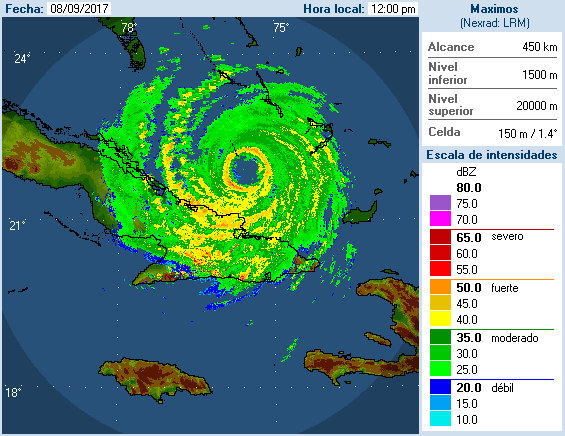
Radar presentation is significantly better than on visible.
0 likes
My posts are my own personal opinion, defer to the National Hurricane Center (NHC) and other NOAA products for decision making during hurricane season.
-
dukeblue219
- S2K Supporter
- Posts: 556
- Joined: Fri Sep 30, 2016 3:52 pm
Re: ATL: IRMA - Hurricane - Discussion
I'm thinking that might have been the last pass for this Air Force mission. The next NOAA plane will enter the storm around 4:30pm EDT.
Edit to add: The vortex message is out, confirming 137 knot surface winds and 928mb.
Edit to add: The vortex message is out, confirming 137 knot surface winds and 928mb.
Last edited by dukeblue219 on Fri Sep 08, 2017 12:28 pm, edited 2 times in total.
1 likes
-
Hypercane_Kyle
- Category 5
- Posts: 3465
- Joined: Sat Mar 07, 2015 7:58 pm
- Location: Cape Canaveral, FL
Re: ATL: IRMA - Hurricane - Discussion
AutoPenalti wrote:Looks like more weakening per recon?
EDIT: Nope, they found 130kts.
Peak uncontaminated SFMR was 137 knots.
1 likes
My posts are my own personal opinion, defer to the National Hurricane Center (NHC) and other NOAA products for decision making during hurricane season.
Re: ATL: IRMA - Hurricane - Discussion
ConvergenceZone wrote:While I don't want to see a Hurricane hit Cuba, if this hits Cuba, it can mean the difference between a Cat 1 hitting Florida as opposed to a Cat 3 or 4 hitting Florida
Or 5, still in play.
0 likes
-
Kenderkin17
- Tropical Low

- Posts: 12
- Joined: Wed Sep 06, 2017 7:40 am
Re: ATL: IRMA - Hurricane - Discussion
I haven't seen anyone talking about Dvorak for Irma recently, did it just become uninteresting or not significant any longer?
0 likes
Who is online
Users browsing this forum: No registered users and 32 guests