ATL: IRMA - Post-Tropical - Discussion

Moderator: S2k Moderators

Message
Author
bordot
Tropical Wave
Tropical Wave
Posts: 8
Age: 36
Joined: Sun Aug 16, 2009 5:09 pm
Location: Las Vegas

Re: ATL: IRMA - Hurricane - Discussion

#9421 Postby bordot » Sat Sep 09, 2017 9:09 am

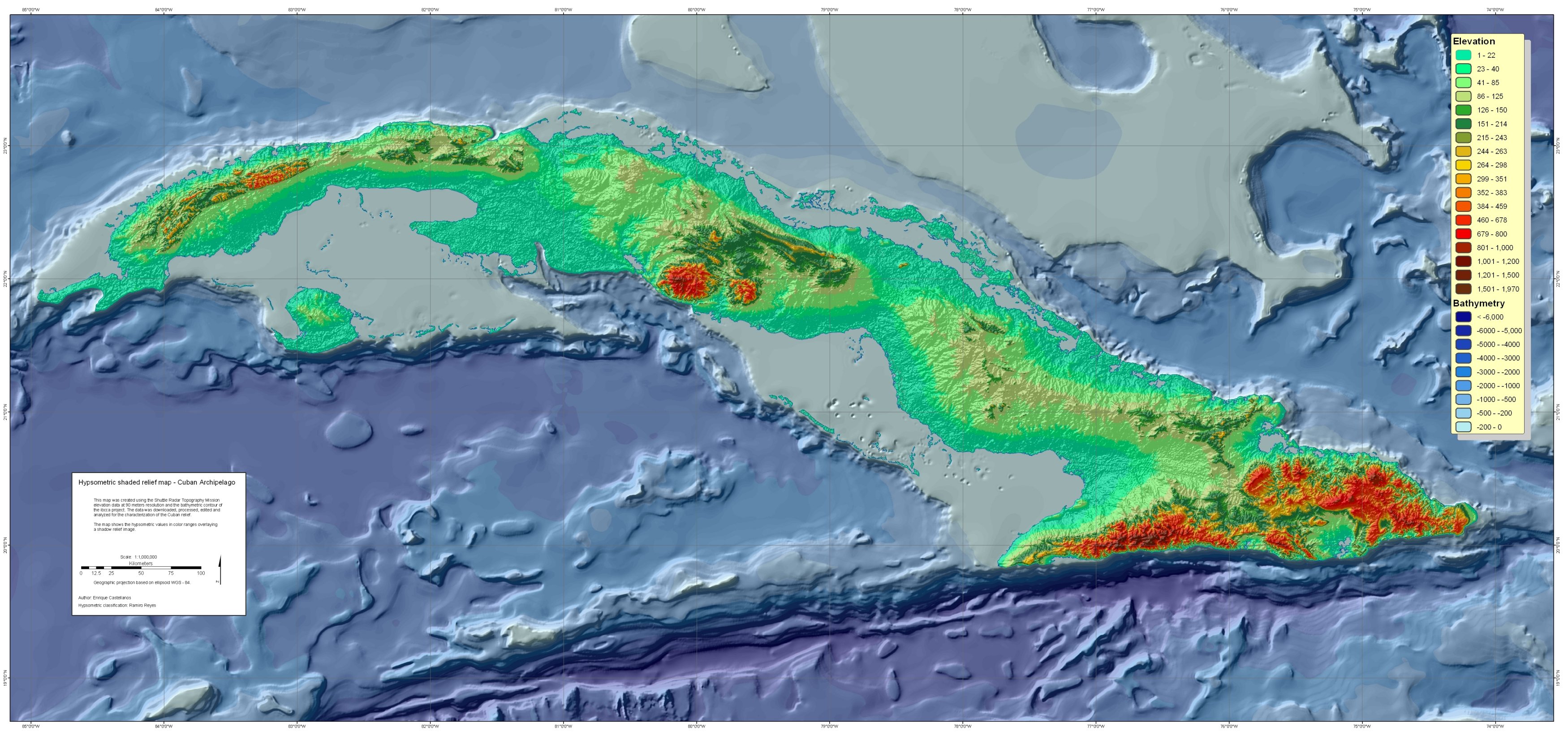
For anyone curious about the effects of Cuba's mountain systems on Irma, check out this topography map of Cuba.

Image

I don't believe she'll be affected much as long as she doesn't go too far SW (unlikely)
0 likes   

stormreader

Re: ATL: IRMA - Hurricane - Discussion

#9422 Postby stormreader » Sat Sep 09, 2017 9:10 am

GCANE wrote:Keeping an eye on the band east of Miami.
Firing off two heavy-duty towers.

Image

Image

Just my average ordinary uninformed opinion, but I don't have a good feeling about this thing coming off the Cuban coast. Structure still really, really good. Small and tightly wound. Latent energy in the storm is very high. No storm can compare with the prolonged Cat 4 and 5 status of this one. That Cuban impact would have taken more out of other storms. Everything is in place for a very quick wind up in the Straits. I don't think 160 mph is out of the question through the keys. IMO
3 likes   

tolakram
Admin
Admin
Posts: 20027
Age: 62
Joined: Sun Aug 27, 2006 8:23 pm
Location: Florence, KY (name is Mark)

Re: ATL: IRMA - Hurricane - Discussion

#9423 Postby tolakram » Sat Sep 09, 2017 9:15 am

 https://twitter.com/pppapin/status/906520347012460544


Philippe Papin @pppapin
Weakening of #Irma over #Cuba is primarily by loss of ocean #LHF. Even w/ flat land, #WISHE too weak for Cat 4-5 TC. http://www.atmos.albany.edu/student/ppa ... h_0p25.php
10:11 AM - Sep 9, 2017 · New York, USA
2 2 Replies 6 6 Retweets 8 8 likes
1 likes   
M a r k
- - - - -
Join us in chat: Storm2K Chatroom Invite. Android and IOS apps also available.

The posts in this forum are NOT official forecasts and should not be used as such. Posts are NOT endorsed by any professional institution or STORM2K.org. For official information and forecasts, please refer to NHC and NWS products.

tatlopuyo
Tropical Low
Tropical Low
Posts: 24
Joined: Sat Aug 26, 2017 8:53 pm

Re: ATL: IRMA - Hurricane - Discussion

#9424 Postby tatlopuyo » Sat Sep 09, 2017 9:17 am

I wouldnt be surprised if this will not turn nw and continue moving w/wnw. Im no expert. Just basing it from experience observing supertyphoons here in the wespac. Haiyan is one example.
1 likes   

tolakram
Admin
Admin
Posts: 20027
Age: 62
Joined: Sun Aug 27, 2006 8:23 pm
Location: Florence, KY (name is Mark)

Re: ATL: IRMA - Hurricane - Discussion

#9425 Postby tolakram » Sat Sep 09, 2017 9:17 am

 https://twitter.com/TropicalTidbits/status/906521576258097152


Levi Cowan @TropicalTidbits
Quick Saturday morning video update on Hurricane #Irma: https://www.tropicaltidbits.com/blog/20 ... h-florida/
10:16 AM - Sep 9, 2017
0 likes   
M a r k
- - - - -
Join us in chat: Storm2K Chatroom Invite. Android and IOS apps also available.

The posts in this forum are NOT official forecasts and should not be used as such. Posts are NOT endorsed by any professional institution or STORM2K.org. For official information and forecasts, please refer to NHC and NWS products.

MBryant
Category 1
Category 1
Posts: 416
Joined: Fri Aug 27, 2004 7:13 pm
Location: Orange, Texas

Re: ATL: IRMA - Hurricane - Discussion

#9426 Postby MBryant » Sat Sep 09, 2017 9:20 am

Is there a chance, albeit a small one, that Irma makes it far enough west to miss the northern steering currents and makes it to the southern steering currents and heads into the Yucatan?
0 likes   
Living at the intersection of Rita and Humberto and Ike and Harvey and Laura and Delta!

This post is NOT an official forecast and should not be used as such. It is just my opinion and may or may not be backed by sound meteorological products.

HenkL
S2K Supporter
S2K Supporter
Posts: 2401
Joined: Fri Sep 10, 2004 5:33 pm
Location: Groningen, The Netherlands
Contact:

Re: ATL: IRMA - Main Recon Thread (Data only)

#9427 Postby HenkL » Sat Sep 09, 2017 9:22 am

URNT12 KNHC 091419
VORTEX DATA MESSAGE AL112017
A. 09/14:02:00Z
B. 22 deg 45 min N
079 deg 35 min W
C. 700 mb 2590 m
D. 99 kt
E. 043 deg 9 nm
F. 120 deg 104 kt
G. 034 deg 17 nm
H. 941 mb
I. 13 C / 3052 m
J. 16 C / 3051 m
K. NA / NA
L. CLOSED
M. C15
N. 12345 / 7
O. 0.02 / 1 nm
P. AF307 2611A IRMA OB 22
MAX OUTBOUND AND MAX FL WIND 105 KT 017 / 22 NM 14:09:00Z
CNTR DROPSONDE SFC WIND 175 / 7
0 likes   

User avatar
Evil Jeremy
S2K Supporter
S2K Supporter
Posts: 5463
Age: 32
Joined: Mon Apr 10, 2006 2:10 pm
Location: Los Angeles, CA

Re: ATL: IRMA - Hurricane - Discussion

#9428 Postby Evil Jeremy » Sat Sep 09, 2017 9:23 am

MBryant wrote:Is there a chance, albeit a small one, that Irma makes it far enough west to miss the northern steering currents and makes it to the southern steering currents and heads into the Yucatan?


Not one computer model presents this as a remote possibility
1 likes   
Frances 04 / Jeanne 04 / Katrina 05 / Wilma 05 / Fay 08 / Debby 12 / Andrea 13 / Colin 16 / Hermine 16 / Matthew 16 / Irma 17

User avatar
ConvergenceZone
Category 5
Category 5
Posts: 5197
Joined: Fri Jul 29, 2005 1:40 am
Location: Northern California

Re: ATL: IRMA - Hurricane - Discussion

#9429 Postby ConvergenceZone » Sat Sep 09, 2017 9:25 am

I knew I'd wake up to a Cat 3. I just knew it, in spite of what some people were saying about it not losing intensity. Cuba does this to storms all the time. If it starts moving away from Cuba now, I think it will maintain strength, but if it continues to ride the coastline for most of the day, then we are probably looking at a Cat 2 heading for Florida.
1 likes   

Mello1
Category 1
Category 1
Posts: 363
Joined: Mon Sep 15, 2003 2:08 pm
Location: Chicago

Re: ATL: IRMA - Hurricane - Discussion

#9430 Postby Mello1 » Sat Sep 09, 2017 9:25 am

MBryant wrote:Is there a chance, albeit a small one, that Irma makes it far enough west to miss the northern steering currents and makes it to the southern steering currents and heads into the Yucatan?

Most folk here have said no already to this.
0 likes   

User avatar
thundercam96
Tropical Storm
Tropical Storm
Posts: 129
Joined: Thu Aug 18, 2011 3:01 pm
Location: Boston, MA

Re: ATL: IRMA - Hurricane - Discussion

#9431 Postby thundercam96 » Sat Sep 09, 2017 9:25 am

tolakram wrote:
thundercam96 wrote:Based on some selective trends that have been showing regarding a weaker hurricane making landfall, I hope this doesn't add to the large complacency factor at hand. An estimated quarter of the states population (5 Million of ~20 million) has evacuated their residence to either another state or nearby locale. In the end, if thing landfalls as a Cat 3, it will have done a lot less damage than the Cat 4/5 they were predicting to hit. It will be great that the damage lessened and lives would be put at a considerably smaller risk throughout the entire state. But, what happens the next time something like this happens? Will the thought of "They always weaken before landfall" or "We evacuated last time and nothing big happened".


Where does one go with that? What does it matter? The forecast was the best possible, the dangers are still real, and if people want to be complacent for the next one and get themselves killed ... so be it. There's not a lot that can really be done. Keep in mind we just came out of a disaster in Houston where people were upset that an evacuation was not done. There is no such thing as the perfect solution.

I think most people know the score, understand the risks, and basically don't make a big deal out of it and so we never hear about it. Houston may have taken a big hit AND helped folks be less complacent about this one.


I understand your point tolakram. I am just disappointed when I look on social media and seeing all of the popup "news" sites speaking of this "Monstrosity Category 5 Super Hurricane" and how its going to destroy Florida/SE US..... from 10 days out. A frightening majority of the general populous take this information like it just came out of the mouth of god. Before you know it, you see friends on Facebook saying that "This storms going to hit Texas" or "There is a 245 MPH storm coming! Lookout!". These were actual quotes from friends I am connected with on social media that are very wise, knowledgeable people who should be able to discern between garbage and facts.
1 likes   
Fay '08 / Mathew 16'

Personal Forecast Disclaimer: I am not a certified meteorologist, therefore, what is posted on this forum under my header should not be treated as an official forecast. Please refer to the NWS/NHC products for forecast information.

Jelff
Tropical Depression
Tropical Depression
Posts: 50
Joined: Tue Aug 29, 2017 3:04 pm
Contact:

Re: ATL: IRMA - Hurricane - Discussion

#9432 Postby Jelff » Sat Sep 09, 2017 9:26 am

The link below will display a Google + GIS (Geographical Information System) map that can show you the water height and wind speed at various data collection stations on the coast.

When the map opens it is centered at Florida and the basemap is a black and white satellite image that refreshes every 30 minutes. If the basemap is black it simply means you are looking at the map when it is nighttime in Florida.

Also when the map opens each green dot is a weather sensing station on the coast. If you click any of those stations then you will see a popup that includes a “data” link. If you follow that “data” link then you will see the official web page for that station. That web page displays a graph of water level. As Irma passes you will be able to see any storm surge measured by the gage.

To see a wind speed graph for this station, look above the water level graph and click the link titled “Meteorological Obs.”

In addition to the coastal gage layer (Tide_wind_and_more), other useful GIS data overlay layers include stream gages and rain gages. If the ‘top' layer you have turned on displays gages, then you can click on a gage and then click the link in the popup and that will open the official web page for that gage.

The map can display 20+ GIS data overlays.

Want to make your own custom map link? Sure, you can do that.

The "Map Tips" link in the upper left corner will show you how to turn the other GIS data overlay layers on/off, how to make your own custom map link and more tips for getting the most benefit from the map.

Coastal gages map: https://bit.ly/2xWCeLA
0 likes   

User avatar
Steve
S2K Supporter
S2K Supporter
Posts: 9623
Joined: Sat Apr 05, 2003 11:41 pm
Location: Not a state-caster

Re: ATL: IRMA - Hurricane - Discussion

#9433 Postby Steve » Sat Sep 09, 2017 9:28 am

MBryant wrote:Is there a chance, albeit a small one, that Irma makes it far enough west to miss the northern steering currents and makes it to the southern steering currents and heads into the Yucatan?


It's going going to run out of time. The trough-reinforcing ULL has crossed into Tennessee and Mississippi and is centered just south of Memphis. It's going to be the feature that helps pull Irma northerly either through or adjacent to SW FL. Run the water vapor loop and see if you can't pick it out.
http://www.ssd.noaa.gov/goes/comp/ceus/wv-animated.gif
1 likes   

stormreader

Re: ATL: IRMA - Hurricane - Discussion

#9434 Postby stormreader » Sat Sep 09, 2017 9:30 am

Image

Easy to pick out eye on latest sat image. Reds reappearing in inner circulation.
0 likes   

Mello1
Category 1
Category 1
Posts: 363
Joined: Mon Sep 15, 2003 2:08 pm
Location: Chicago

Re: ATL: IRMA - Hurricane - Discussion

#9435 Postby Mello1 » Sat Sep 09, 2017 9:30 am

ConvergenceZone wrote:I knew I'd wake up to a Cat 3. I just knew it, in spite of what some people were saying about it not losing intensity. Cuba does this to storms all the time. If it starts moving away from Cuba now, I think it will maintain strength, but if it continues to ride the coastline for most of the day, then we are probably looking at a Cat 2 heading for Florida.

I felt the storm would move more westerly before it turns, but in my no-weather expert opinion, the storm's sheer size contributes to its energy that will not see it weakening below a 3 -- especially once it does make the turn north and the eye is back over very warm waters. It will strengthen IMO. I would look at the wind speed and how much time she has to get it together once over the GOM.
1 likes   

tolakram
Admin
Admin
Posts: 20027
Age: 62
Joined: Sun Aug 27, 2006 8:23 pm
Location: Florence, KY (name is Mark)

Re: ATL: IRMA - Hurricane - Discussion

#9436 Postby tolakram » Sat Sep 09, 2017 9:30 am

thundercam96 wrote:I understand your point tolakram. I am just disappointed when I look on social media and seeing all of the popup "news" sites speaking of this "Monstrosity Category 5 Super Hurricane" and how its going to destroy Florida/SE US..... from 10 days out. A frightening majority of the general populous take this information like it just came out of the mouth of god. Before you know it, you see friends on Facebook saying that "This storms going to hit Texas" or "There is a 245 MPH storm coming! Lookout!". These were actual quotes from friends I am connected with on social media that are very wise, knowledgeable people who should be able to discern between garbage and facts.


But you aren't really surprised are you? Let's move on, not your fault but this will never change. It will either not be as bad as feared, just as bad, or worse. Social media is a playground for people to get attention. I do not think it's a majority of people, but I have no way to prove that stat other than to point to the massive numbers of people who evacuated when told of the danger.
3 likes   
M a r k
- - - - -
Join us in chat: Storm2K Chatroom Invite. Android and IOS apps also available.

The posts in this forum are NOT official forecasts and should not be used as such. Posts are NOT endorsed by any professional institution or STORM2K.org. For official information and forecasts, please refer to NHC and NWS products.

MBryant
Category 1
Category 1
Posts: 416
Joined: Fri Aug 27, 2004 7:13 pm
Location: Orange, Texas

Re: ATL: IRMA - Hurricane - Discussion

#9437 Postby MBryant » Sat Sep 09, 2017 9:31 am

Evil Jeremy wrote:
MBryant wrote:Is there a chance, albeit a small one, that Irma makes it far enough west to miss the northern steering currents and makes it to the southern steering currents and heads into the Yucatan?


Not one computer model presents this as a remote possibility

I wouldn't expect it to since it would be a statistical anomaly rather than a probability.

THIS IS THEORETICAL ONLY and not likely. It's probably the wrong time to ask the question at all with so many in imminent danger. Prepare as if the worst case is coming for you and hope it is not. Be thankful if it is not.
0 likes   
Living at the intersection of Rita and Humberto and Ike and Harvey and Laura and Delta!

This post is NOT an official forecast and should not be used as such. It is just my opinion and may or may not be backed by sound meteorological products.

User avatar
Steve
S2K Supporter
S2K Supporter
Posts: 9623
Joined: Sat Apr 05, 2003 11:41 pm
Location: Not a state-caster

Re: ATL: IRMA - Hurricane - Discussion

#9438 Postby Steve » Sat Sep 09, 2017 9:32 am

ConvergenceZone wrote:I knew I'd wake up to a Cat 3. I just knew it, in spite of what some people were saying about it not losing intensity. Cuba does this to storms all the time. If it starts moving away from Cuba now, I think it will maintain strength, but if it continues to ride the coastline for most of the day, then we are probably looking at a Cat 2 heading for Florida.


Don't sleep on conditions progged south of the FL Keys. If Cuba knocks it down to a 2, it could still get back to a 4 and is expected to do so. GFS has been overestimating pressure but takes it back down to the 920s. If that's 15mb too low, 930s is still brutal. You know I'm not knocking your post, but I wouldn't underestimate the likely damage we will all be paying for.
Last edited by Steve on Sat Sep 09, 2017 9:42 am, edited 1 time in total.
3 likes   

clambite
S2K Supporter
S2K Supporter
Posts: 15
Age: 72
Joined: Tue Aug 23, 2016 9:26 am
Location: Morehead City, NC

Re: ATL: IRMA - Hurricane - Discussion

#9439 Postby clambite » Sat Sep 09, 2017 9:35 am

tatlopuyo wrote:I wouldnt be surprised if this will not turn nw and continue moving w/wnw. Im no expert. Just basing it from experience observing supertyphoons here in the wespac. Haiyan is one example.


I would think counter clockwise vs. clockwise would have the opposite effect.
2 likes   

User avatar
hiflyer
S2K Supporter
S2K Supporter
Posts: 563
Joined: Wed Sep 08, 2004 11:24 am
Location: West Broward Florida

Re: ATL: IRMA - Hurricane - Discussion

#9440 Postby hiflyer » Sat Sep 09, 2017 9:38 am

MBryant wrote:Is there a chance, albeit a small one, that Irma makes it far enough west to miss the northern steering currents and makes it to the southern steering currents and heads into the Yucatan?


Better hope not cause about 20 big empty cruise ships fled florida ports for the Yucatan channel yesterday morning to ride out the storm!!!
1 likes   


Return to “2017”

Who is online

Users browsing this forum: No registered users and 9 guests