Edit: Here are the missing obs:
URNT15 KWBC 092141
NOAA2 2711A IRMA HDOB 27 20170909
213130 2350N 08120W 6956 02992 9810 +124 +115 045064 065 061 006 00
213200 2348N 08118W 6957 02986 9803 +124 +114 045066 068 060 006 00
213230 2347N 08117W 6956 02981 9794 +127 +116 042068 068 059 005 00
213300 2345N 08115W 6957 02972 9786 +128 +115 041071 071 059 006 00
213330 2344N 08114W 6957 02967 9779 +127 +120 042072 073 059 006 00
213400 2342N 08112W 6954 02961 9769 +126 //// 039069 072 058 016 05
213430 2341N 08110W 6957 02949 9755 +132 +119 039069 070 059 011 03
213500 2340N 08109W 6961 02934 9752 +126 +120 038072 075 060 004 00
213530 2338N 08107W 6958 02925 9740 +126 +110 040078 080 061 004 00
213600 2337N 08106W 6964 02907 9721 +131 +112 039084 086 061 003 00
213630 2335N 08104W 6958 02901 9702 +136 +106 038087 088 062 005 00
213700 2334N 08102W 6952 02894 9687 +134 +120 037086 087 063 012 00
213730 2332N 08101W 6957 02871 9669 +134 +127 034090 091 068 010 00
213800 2331N 08059W 6951 02858 9644 +137 +116 034095 098 071 010 00
213830 2329N 08057W 6952 02832 9620 +135 +105 033099 101 073 023 00
213900 2328N 08056W 6967 02784 9583 +137 +129 032098 103 078 045 00
213930 2326N 08054W 6975 02736 9532 +147 //// 024084 085 091 021 01
214000 2324N 08052W 6968 02718 9492 +159 +140 023085 086 090 006 00
214030 2323N 08051W 6956 02702 9462 +157 +132 018085 085 076 005 00
214100 2321N 08049W 6959 02656 9420 +160 +127 013087 088 066 008 00
URNT15 KWBC 092131
NOAA2 2711A IRMA HDOB 26 20170909
212130 2418N 08152W 6958 03084 9932 +114 +088 044065 066 /// /// 03
212200 2417N 08150W 6968 03071 9928 +116 +081 039065 066 047 003 00
212230 2415N 08149W 6951 03090 9930 +110 +093 043066 067 048 002 00
212300 2414N 08147W 6954 03081 9917 +117 +086 043067 068 048 003 00
212330 2413N 08145W 6961 03069 9918 +112 +093 043065 067 048 004 00
212400 2411N 08144W 6959 03067 9915 +112 +087 044064 065 049 004 00
212430 2410N 08142W 6954 03069 9909 +114 +084 045068 069 051 004 00
212500 2408N 08141W 6962 03056 9907 +112 +078 043068 069 051 005 00
212530 2407N 08139W 6961 03053 9899 +117 +071 038070 075 051 003 00
212600 2405N 08137W 6957 03054 9900 +108 +095 040072 078 050 006 00
212630 2404N 08136W 6957 03047 9881 +118 +104 042065 065 052 004 00
212700 2403N 08134W 6953 03049 9877 +120 +099 042066 067 054 003 00
212730 2401N 08133W 6953 03045 9874 +118 +102 042068 070 055 004 00
212800 2400N 08131W 6960 03029 9866 +118 +107 044069 070 055 004 00
212830 2358N 08129W 6954 03033 9861 +119 +103 045070 071 056 005 00
212900 2357N 08128W 6960 03020 9853 +120 +109 044069 070 056 006 00
212930 2355N 08126W 6957 03019 9848 +118 +115 044071 074 056 006 00
213000 2354N 08125W 6951 03022 9835 +124 +116 046076 078 057 011 00
213030 2353N 08123W 6949 03015 9832 +115 //// 047075 081 060 012 05
213100 2351N 08122W 6961 02990 9817 +121 //// 047066 066 059 005 01
Some transmission issues from Kermit, this is OB 27:
URNT15 KWBC 092141
NOAA2 2711A IRMA HDOB 27 20170909
213130 2350N 08120W 6956 02992 9810 +124 +115 045064 065 061 006 00
213200 2348N 08118W 6957 02986 9803 +124 +114 045066 068 060 006 00
213230 2347N 08117W 6956 02981 9794 +127 +116 042068 068 059 005 00
213300 2345N 08115W 6957 02972 9786 +128 +115 041071 071 059 006 00
213330 2344N 08114W 6957 02967 9779 +127 +120 042072 073 059 006 00
213400 2342N 08112W 6954 02961 9769 +126 //// 039069 072 058 016 05
213430 2341N 08110W 6957 02949 9755 +132 +119 039069 070 059 011 03
213500 2340N 08109W 6961 02934 9752 +126 +120 038072 075 060 004 00
213530 2338N 08107W 6958 02925 9740 +126 +110 040078 080 061 004 00
213600 2337N 08106W 6964 02907 9721 +131 +112 039084 086 061 003 00
213630 2335N 08104W 6958 02901 9702 +136 +106 038087 088 062 005 00
213700 2334N 08102W 6952 02894 9687 +134 +120 037086 087 063 012 00
213730 2332N 08101W 6957 02871 9669 +134 +127 034090 091 068 010 00
213800 2331N 08059W 6951 02858 9644 +137 +116 034095 098 071 010 00
213830 2329N 08057W 6952 02832 9620 +135 +105 033099 101 073 023 00
213900 2328N 08056W 6967 02784 9583 +137 +129 032098 103 078 045 00
213930 2326N 08054W 6975 02736 9532 +147 //// 024084 085 091 021 01
214000 2324N 08052W 6968 02718 9492 +159 +140 023085 086 090 006 00
214030 2323N 08051W 6956 02702 9462 +157 +132 018085 085 076 005 00
214100 2321N 08049W 6959 02656 9420 +160 +127 013087 088 066 008 00
ATL: IRMA - Post-Tropical - Discussion
Moderator: S2k Moderators
-
Kingarabian

- S2K Supporter

- Posts: 16351
- Joined: Sat Aug 08, 2009 3:06 am
- Location: Honolulu, Hawaii
-
O Town
- S2K Supporter
- Posts: 5205
- Age: 52
- Joined: Wed Sep 07, 2005 9:37 pm
- Location: Orlando, Florida 28°35'35"N 81°22'55"W
Re: ATL: IRMA - Hurricane - Discussion
Blown Away wrote:
5pm track shifted @20 miles East up to @Ft. Myers...

What's the link to that radar? Lost all my links a while ago
0 likes
#ORLANDOSTRONG
-
tolakram
- Admin

- Posts: 20181
- Age: 62
- Joined: Sun Aug 27, 2006 8:23 pm
- Location: Florence, KY (name is Mark)
Re: ATL: IRMA - Hurricane - Discussion
Zadok wrote:They have the cone covering more of Alabama.
Remember the cone is a circle around every forecast point, the size represents the average error at that forecast timepoint.
Definition here: http://www.nhc.noaa.gov/aboutcone.shtml
Here is the archive for those following the left shift. Not fantastic, but not outside the error cone.
http://www.nhc.noaa.gov/archive/2017/IRMA_graphics.php?product=5day_cone_no_line
2 likes
M a r k
- - - - -
Join us in chat: Storm2K Chatroom Invite. Android and IOS apps also available.
The posts in this forum are NOT official forecasts and should not be used as such. Posts are NOT endorsed by any professional institution or STORM2K.org. For official information and forecasts, please refer to NHC and NWS products.
-
Nederlander
- S2K Supporter
- Posts: 1259
- Joined: Sat Jul 19, 2008 4:28 pm
- Location: Conroe, TX
Re: ATL: IRMA - Hurricane - Discussion
SNOW_JOKE wrote:Less talked about is the potential for ground-flooding due to the rainfall forecast, FL has a aquifer-system beneath the state not only potentially raising the ground-water upwards but also stopping any rain-water from easily draining away due to the combination of the both.
With that in mind, is there any potential for a 'brown-ocean' effect to happen over FL due to the everglades and swamplands.
Yes, but it is my understanding that this is accounted for in model progs and forecasts. Additionally, NHC forecast track places Irma's core to the west of the Everglades as it treks northward. That being said, other things being equal, a TC over Florida will generally weaken slower than one over drier land. A lot of moisture down there to work with.
0 likes

Re: ATL: IRMA - Hurricane - Discussion
She's starting to really look pretty again, that is very unfortunate, as I think this has an excellent chance of getting back to Cat 5, and if she stays off shore by even just 50 miles until the panhandle, she won't lose much energy.
1 likes
Personal Forecast Disclaimer:
The posts in this forum are NOT official forecast and should not be used as such. They are just the opinion of the poster and may or may not be backed by sound meteorological data. They are NOT endorsed by any professional institution or storm2k.org. For official information, please refer to the NHC and NWS products.
The posts in this forum are NOT official forecast and should not be used as such. They are just the opinion of the poster and may or may not be backed by sound meteorological data. They are NOT endorsed by any professional institution or storm2k.org. For official information, please refer to the NHC and NWS products.
Re: ATL: IRMA - Hurricane - Discussion
Rail Dawg wrote:I'm sitting in my truck in a parking garage in downtown historic Naples.
I'm about 15 ft up and can go to 40 ft if need be.
Lots of food water batteries gas shotgun chainsaw.
Wind is picking up and the clouds are getting darker.
The anticipation is palatable.
Just did Harvey with many neighbors (I live in Houston) flooded out and now this.
Miss Irma is coming and for better or for worse the time is now arriving.
Good luck my friends!!
Advise go 25ft up
Surge may be 15ft in your locale
Godspeed my friend, you are in our prayers.
4 likes

Re: ATL: IRMA - Hurricane - Discussion
Key West and Big Pine Key under tornado warning.
Tornado Warning including Key West FL, Big Pine Key FL, Summerland Key FL until 6:00 PM EDT https://t.co/z4z90i5KpD
Tornado Warning including Key West FL, Big Pine Key FL, Summerland Key FL until 6:00 PM EDT https://t.co/z4z90i5KpD
1 likes
-
Meteorcane

- Category 2

- Posts: 559
- Joined: Thu Jul 21, 2011 6:49 am
- Location: North Platte Nebraska
Re: ATL: IRMA - Hurricane - Discussion
Widespread 75-80kt radial velocities at 2-3.5k feet in some of the outer bands going over the keys right now, could be some hurricane force gusts at the surface.
0 likes

Re: ATL: IRMA - Hurricane - Discussion
Portastorm wrote:PTPatrick wrote:There's a great map I found that shows what would flood in key west under different surge height. And it really is all but a few blocks in the middle. Even the shelter at the high school is nothing but last resort. It would flood deeply at predicted surge. It's built for cat 5 wind. I imagine they will have people in second floors?
http://www.cityofkeywest-fl.gov/egov/do ... 922484.htm
Interesting. Wonder what the elevation is of the NWS office. They can handle Cat 5 winds but what happens with storm surge?
From a story about it...looks about 14 ft starting and has a second floor area It looks like:
"The outer part of the facility was designed to hold up against winds of 165 miles (265 kilometers) an hour.
And if the fiercest of hurricanes manages to penetrate the structure's exterior walls, the staff can retreat to an interior bunker that will protect them from winds of up to 255 miles (410 kilometers) an hour.
The ground floor of the building is 14 feet (4.3 meters) above sea level—high enough to be above most hurricanes' storm surges.
"The staff can carry out their mission without worrying about personal safety," said Jon Rizzo, an NWS meteorologist based in Key West."
I will add, I'm not buying 15-20k stayed in the keys. I read a story where only a few hundred have arrived at key west high. I'm guessing If there were thousands, many more would have shown up.
Last edited by PTPatrick on Sat Sep 09, 2017 4:56 pm, edited 1 time in total.
3 likes
-
KBBOCA
- S2K Supporter
- Posts: 1559
- Joined: Fri Sep 05, 2003 5:27 am
- Location: Formerly Boca Raton, often West Africa. Currently Charlotte NC
Re: ATL: IRMA - Hurricane - Discussion
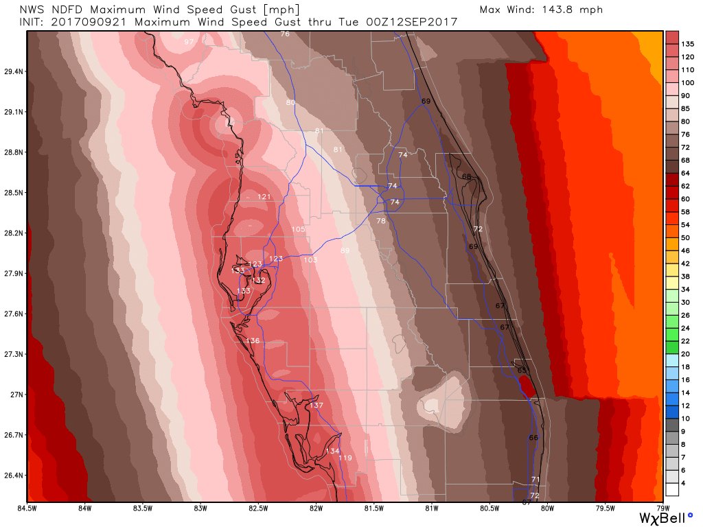
https://twitter.com/ericfisher/status/906635420972314627
Eric FisherVerified account @ericfisher 2m2 minutes ago
Updated wind gust forecast for tomorrow into tomorrow night. A thrashing from the Keys to Naples to Ft. Myers to Tampa. #Irma
image: https://pbs.twimg.com/media/DJUEE9EUQAElfBG.jpg
And yes, this graphic is based on a NWS product, not some independent model.
0 likes
-
CaptinCrunch

- S2K Supporter
- Posts: 8779
- Age: 58
- Joined: Mon Nov 03, 2003 4:33 pm
- Location: Kennedale, TX (Tarrant Co.)
Re: ATL: IRMA - Hurricane - Discussion
Latest models have Irma @ strong C4 crossing Key West, and borderline C4/C5 @ main landfall in SW Florida
1 likes
Re: ATL: IRMA - Hurricane - Discussion
jdjaguar wrote:Rail Dawg wrote:I'm sitting in my truck in a parking garage in downtown historic Naples.
I'm about 15 ft up and can go to 40 ft if need be.
Lots of food water batteries gas shotgun chainsaw.
Wind is picking up and the clouds are getting darker.
The anticipation is palatable.
Just did Harvey with many neighbors (I live in Houston) flooded out and now this.
Miss Irma is coming and for better or for worse the time is now arriving.
Good luck my friends!!
Advise go 25ft up
Surge may be 15ft in your locale
Godspeed my friend, you are in our prayers.
I would go up to the highest covered level of that parking garage, because it isn't just the storm surge which might be higher than 15 feet, you got to add the waves on top of that. But make sure the parking garage is not that old and has a good foundation and thick support.
2 likes
Personal Forecast Disclaimer:
The posts in this forum are NOT official forecast and should not be used as such. They are just the opinion of the poster and may or may not be backed by sound meteorological data. They are NOT endorsed by any professional institution or storm2k.org. For official information, please refer to the NHC and NWS products.
The posts in this forum are NOT official forecast and should not be used as such. They are just the opinion of the poster and may or may not be backed by sound meteorological data. They are NOT endorsed by any professional institution or storm2k.org. For official information, please refer to the NHC and NWS products.
-
Kingarabian
- S2K Supporter
- Posts: 16351
- Joined: Sat Aug 08, 2009 3:06 am
- Location: Honolulu, Hawaii
Re: ATL: IRMA - Hurricane - Discussion
931mb extrap pressure, winds still at 100kts.
0 likes
RIP Kobe Bryant
-
Kingarabian
- S2K Supporter
- Posts: 16351
- Joined: Sat Aug 08, 2009 3:06 am
- Location: Honolulu, Hawaii
Re: ATL: IRMA - Main Recon Thread (Data only)
000
URNT15 KWBC 092151
NOAA2 2711A IRMA HDOB 28 20170909
214130 2320N 08047W 6953 02623 9372 +162 +143 010071 083 061 008 00
214200 2319N 08044W 6940 02613 9333 +176 +158 355032 041 062 003 03
214230 2319N 08042W 6965 02581 9322 +181 +159 351011 015 016 001 00
214300 2319N 08040W 6957 02585 9313 +185 +155 028007 007 013 001 03
214330 2319N 08038W 6962 02575 9315 +181 +147 178009 020 016 002 00
214400 2319N 08035W 6958 02589 9335 +169 +153 182034 043 035 003 00
214430 2319N 08033W 6957 02616 9367 +161 //// 186060 070 074 009 01
214500 2319N 08031W 6967 02650 9430 +144 //// 182081 082 080 015 01
214530 2319N 08029W 6957 02699 9466 +149 +142 179078 078 085 008 00
214600 2319N 08026W 6959 02727 9502 +145 +139 182078 081 086 015 00
214630 2319N 08024W 6959 02756 9540 +136 //// 185093 094 081 027 01
214700 2319N 08022W 6957 02788 9573 +137 //// 182092 095 080 015 01
214730 2319N 08020W 6958 02815 9610 +133 +123 185092 093 079 011 00
214800 2319N 08018W 6961 02838 9641 +129 +112 183087 089 074 006 00
214830 2319N 08015W 6952 02867 9663 +128 +124 182082 084 069 009 00
214900 2319N 08013W 6958 02875 9682 +125 //// 184081 082 067 011 01
214930 2319N 08011W 6955 02894 9699 +124 //// 179080 081 063 016 01
215000 2319N 08009W 6958 02906 9718 +122 //// 176077 077 060 012 01
215030 2319N 08007W 6959 02917 9733 +122 //// 178076 076 058 008 01
215100 2319N 08005W 6957 02932 9747 +121 +121 177072 073 056 006 00
0 likes
RIP Kobe Bryant
Re: ATL: IRMA - Hurricane - Discussion
Blinhart wrote:jdjaguar wrote:Rail Dawg wrote:I'm sitting in my truck in a parking garage in downtown historic Naples.
I'm about 15 ft up and can go to 40 ft if need be.
Lots of food water batteries gas shotgun chainsaw.
Wind is picking up and the clouds are getting darker.
The anticipation is palatable.
Just did Harvey with many neighbors (I live in Houston) flooded out and now this.
Miss Irma is coming and for better or for worse the time is now arriving.
Good luck my friends!!
Advise go 25ft up
Surge may be 15ft in your locale
Godspeed my friend, you are in our prayers.
I would go up to the highest covered level of that parking garage, because it isn't just the storm surge which might be higher than 15 feet, you got to add the waves on top of that. But make sure the parking garage is not that old and has a good foundation and thick support.
This is where it gets tricky, the higher up, the higher the winds
2 likes


-
WeatherGuesser
- Category 5

- Posts: 2672
- Joined: Tue Jun 29, 2010 6:46 am
Re: ATL: IRMA - Hurricane - Discussion
Hurricane Irma Tropical Cyclone Update
NWS National Hurricane Center Miami FL AL112017
600 PM EDT Sat Sep 09 2017
...600 PM EDT POSITION UPDATE...
...TROPICAL STORM CONDITIONS NOW OCCURRING IN THE FLORIDA KEYS...
A National Ocean Service station in Vaca Key recently reported
sustained winds of 46 mph (74 km/h) with a gust to 59 mph
(94 km/h). Marathon recently reported sustained winds of 43 mph
(69 km/h) with a gust to 66 mph (106 km/h).
0 likes
-
KBBOCA
- S2K Supporter
- Posts: 1559
- Joined: Fri Sep 05, 2003 5:27 am
- Location: Formerly Boca Raton, often West Africa. Currently Charlotte NC
Re: ATL: IRMA - Hurricane - Discussion
NWS MiamiVerified account @NWSMiami 3m3 minutes ago
5 PM info on #Irma: 23.4N 80.5W, Max sustained wind 125 mph, Pressure 933 mb, moving WNW 9 mph. Eye 200 mi SSE of Naples. #flwx
5 PM info on #Irma: 23.4N 80.5W, Max sustained wind 125 mph, Pressure 933 mb, moving WNW 9 mph. Eye 200 mi SSE of Naples. #flwx
0 likes

Re: ATL: IRMA - Hurricane - Discussion
Looks like pressure is down a couple of more mb, extrap : 931.3 mb
(~ 27.50 inHg)
(~ 27.50 inHg)
0 likes
Re: ATL: IRMA - Hurricane - Discussion
You can download the free Broadcastify app on your phone to listen to police and public safety scanners worldwide. Good way to keep abreast of that's going on before, during and after. Just search for scanners in your area of interest.
2 likes
Who is online
Users browsing this forum: No registered users and 48 guests