ATL: FLORENCE - Post-Tropical - Discussion

Moderator: S2k Moderators

Message
Author
User avatar
chaser1
S2K Supporter
S2K Supporter
Posts: 5472
Age: 64
Joined: Sat Oct 15, 2005 5:59 pm
Location: Longwood, Fl

Re: ATL: FLORENCE - Tropical Storm - Discussion

#1081 Postby chaser1 » Sat Sep 08, 2018 6:10 pm

gatorcane wrote:
otowntiger wrote:
toad strangler wrote:
Way to far out to determine that model shifts are done. NHC specifically mentions NORTH FL through NC as the region that should be preparing NOW. That's a pretty big spread. More changes to come for sure. Within that scope.

I’m pretty sure that major shifts are done. I believe that the cone is pretty much what it will be. NHC is really good with track 5 days and less. Carolina hit- north or south or both.


Agreed looks like a Carolina hit or just offshore. FLORIDA particularly central and south look to be in the clear. Still not all clear for north Florida yet.


Famous last words :wink:
1 likes   
Andy D

(For official information, please refer to the NHC and NWS products.)

Ken711
Category 5
Category 5
Posts: 1074
Joined: Tue Aug 28, 2012 12:48 pm

Re: ATL: FLORENCE - Tropical Storm - Discussion

#1082 Postby Ken711 » Sat Sep 08, 2018 6:13 pm

chaser1 wrote:
gatorcane wrote:
otowntiger wrote:I’m pretty sure that major shifts are done. I believe that the cone is pretty much what it will be. NHC is really good with track 5 days and less. Carolina hit- north or south or both.


Agreed looks like a Carolina hit or just offshore. FLORIDA particularly central and south look to be in the clear. Still not all clear for north Florida yet.


Famous last words :wink:


I think the cone will only shift north and east from here on out if it moves very much.
1 likes   

jdjaguar
Category 2
Category 2
Posts: 551
Joined: Fri Aug 26, 2005 12:07 pm
Location: Jacksonville Beach, FL

Re: ATL: FLORENCE - Tropical Storm - Discussion

#1083 Postby jdjaguar » Sat Sep 08, 2018 6:14 pm

LCfromFL wrote:First, let me say that you should ALWAYS listen to local officials when it comes to evacuating. Now having said that, this surge map may be helpful in visualizing the impact of surge in your area. I live nearly 25 miles - yes miles -inland and we could be affected by storm surge. Worst case scenario for a Cat 5 would have more than 9 FEET of surge. :eek: Hide from the wind. Run from the water. Be safe.

It has been my experience that if you wait for
Local officials, it’s too late

http://noaa.maps.arcgis.com/apps/MapSeries/index.html?appid=d9ed7904dbec441a9c4dd7b277935fad&entry=1
0 likes   

User avatar
TheDreamTraveler
Category 2
Category 2
Posts: 641
Joined: Sun Aug 22, 2010 3:10 am
Location: PA

Re: ATL: FLORENCE - Tropical Storm - Discussion

#1084 Postby TheDreamTraveler » Sat Sep 08, 2018 6:14 pm

4 likes   

dspguy
Tropical Depression
Tropical Depression
Posts: 61
Joined: Wed Sep 06, 2017 2:26 pm
Location: Charleston, SC

Re: ATL: FLORENCE - Tropical Storm - Discussion

#1085 Postby dspguy » Sat Sep 08, 2018 6:18 pm

LCfromFL wrote:I live nearly 25 miles - yes miles -inland and we could be affected by storm surge.

Same here (but in SC). I'm about 20 miles as the crow flies and the river near my house overflows its banks a few times/year. If the area gets a few inches of rain and all the water from Columbia comes down to Charleston, there is flooding. And that's before we even talk about storm surge. The "Low Country," as they call it, is a swamp on a dry day. Downtown Charleston floods with any heavy rain even if it isn't drawn out over a long span of time. I can't imagine what that will be like with storm surge mixed in.

Florence would be devastating wherever it makes landfall. There was a study about "what if" Hugo had landed about 50 miles south of where it did land. Essentially, if it hit the Folly Beach area. Near absolute devastation.

Personally, I finished my immediate storm prep already. Serviced the generator, got fuel, double checked my shelf-stable supplies, verified evac plans. Preferably, I don't put any of this into play and wind up using the gas in my car, use the food supplies after the season is over and winterize the generator.
8 likes   

User avatar
Three Blind Mice
Tropical Storm
Tropical Storm
Posts: 202
Joined: Thu Jul 29, 2004 9:28 am
Location: Wrightsville Beach, NC

Re: ATL: FLORENCE - Tropical Storm - Discussion

#1086 Postby Three Blind Mice » Sat Sep 08, 2018 6:42 pm

chaser1 wrote:
Three Blind Mice wrote:Wrightsville Beach High Tide for Thursday night is 11:13pm 4.6' feet, next high tide is Friday at 11;46am 5.1' feet


Question: Do you recall which was the last storm to fairly directly strike Wrightsville Beach?


Fran in 1996 was the last storm ro really hammer us. 4-6 feet of surge over entire beach. Floyd was more rain and wind as I recall. Lots of near misses or wind events.

Someone in my office was down at Ft. Fisher last week looking at the surge marks on a telephone pole. She said Fran was about 5 foot and she wondered where Hazel's mark was. Someone pointed to the top of the telephone pole where a marker said Hazel!!!
0 likes   

User avatar
artist
Category 5
Category 5
Posts: 9792
Joined: Mon Jun 06, 2005 3:26 pm
Location: West Palm

Re: ATL: FLORENCE - Tropical Storm - Discussion

#1087 Postby artist » Sat Sep 08, 2018 7:07 pm

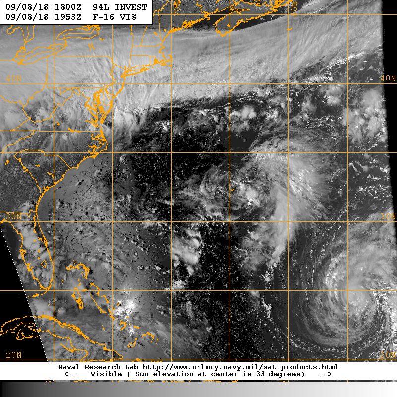
Image

I know this is labeled for 94l, but it shows Florence off to the se and a view of the US as well, so thought I’d share here. 94l is the blob to the just above Florence.
5 likes   

hipshot
Category 2
Category 2
Posts: 591
Joined: Tue Jul 06, 2010 9:18 pm
Location: Dallas, Texas

Re: ATL: FLORENCE - Tropical Storm - Discussion

#1088 Postby hipshot » Sat Sep 08, 2018 7:11 pm

artist wrote:Image

I know this is labeled for 94l, but it shows Florence off to the se and a view of the US as well, so thought I’d share here. 94l is the blob to the just above Florence.


You can sure see from that photo that 94L could really accentuate the anticyclone for Florence and increase her intensity.
2 likes   

User avatar
chaser1
S2K Supporter
S2K Supporter
Posts: 5472
Age: 64
Joined: Sat Oct 15, 2005 5:59 pm
Location: Longwood, Fl

Re: ATL: FLORENCE - Tropical Storm - Discussion

#1089 Postby chaser1 » Sat Sep 08, 2018 7:19 pm

Three Blind Mice wrote:
chaser1 wrote:
Three Blind Mice wrote:Wrightsville Beach High Tide for Thursday night is 11:13pm 4.6' feet, next high tide is Friday at 11;46am 5.1' feet


Question: Do you recall which was the last storm to fairly directly strike Wrightsville Beach?


Fran in 1996 was the last storm ro really hammer us. 4-6 feet of surge over entire beach. Floyd was more rain and wind as I recall. Lots of near misses or wind events.

Someone in my office was down at Ft. Fisher last week looking at the surge marks on a telephone pole. She said Fran was about 5 foot and she wondered where Hazel's mark was. Someone pointed to the top of the telephone pole where a marker said Hazel!!!


Thanks, I was just trying to recall a particular hurricane that I'm pretty sure I chased there but don't believe those two were either of them. Yeah you guys certainly are magnets for 'canes over the years lol!
0 likes   
Andy D

(For official information, please refer to the NHC and NWS products.)

User avatar
KWT
Category 5
Category 5
Posts: 31415
Joined: Tue Aug 17, 2004 11:02 am
Location: UK!!!

Re: ATL: FLORENCE - Tropical Storm - Discussion

#1090 Postby KWT » Sat Sep 08, 2018 7:19 pm

Really is impressive that the NHC has gone so high right out the block with this one. Got good model support for it to be in that range mind you.

Surely would be one of the biggest ever hits from that direction. (Usually cat-4 strikes come up from the Caribbean) area.
1 likes   
Personal Forecast Disclaimer:
The posts in this forum are NOT official forecast and should not be used as such. They are just the opinion of the poster and may or may not be backed by sound meteorological data. They are NOT endorsed by any professional institution or storm2k.org. For official information, please refer to the NHC and NWS products

Ken711
Category 5
Category 5
Posts: 1074
Joined: Tue Aug 28, 2012 12:48 pm

Re: ATL: FLORENCE - Tropical Storm - Discussion

#1091 Postby Ken711 » Sat Sep 08, 2018 7:30 pm

Do we expect that NHC will slightly shift the cone north and east more in line with the 18z runs with their 11:00 report?
0 likes   

WilmingtonSandbar
S2K Supporter
S2K Supporter
Posts: 505
Joined: Sun Aug 29, 2010 12:11 pm
Location: Southport, NC

Re: ATL: FLORENCE - Tropical Storm - Discussion

#1092 Postby WilmingtonSandbar » Sat Sep 08, 2018 7:52 pm

chaser1 wrote:
Three Blind Mice wrote:Wrightsville Beach High Tide for Thursday night is 11:13pm 4.6' feet, next high tide is Friday at 11;46am 5.1' feet


Question: Do you recall which was the last storm to fairly directly strike Wrightsville Beach?

Are you asking that question, because you doubt that Wrightsville Beach gets hit? Mathew was the last one to directly effect us, but I can go back a few years if you need me to.
0 likes   
Diana X2 (look it up), Bertha, Fran, Bonnie, Floyd, Dennis, Charley, Ophelia, Ernesto, Irene, Matthew, And Florence

drewschmaltz
S2K Supporter
S2K Supporter
Posts: 350
Joined: Thu Aug 27, 2015 8:19 pm

Re: ATL: FLORENCE - Tropical Storm - Discussion

#1093 Postby drewschmaltz » Sat Sep 08, 2018 7:53 pm

Ridge provides massive outflow channel, 94L provides bountiful moisture, sea surface temperatures along the path are among warmest in the Atlantic. Florenece attained category 4 already. Peak intensity may be interesting... Irma got to 185...
0 likes   
I HAVE ABSOLUTELY NO IDEA WHAT I'M TALKING ABOUT. PLEASE CONSULT SOMEONE WHO DOES. START WITH THE NHC. ALL POSTS ARE FOR ENTERTAINMENT PURPOSES ONLY.

User avatar
chaser1
S2K Supporter
S2K Supporter
Posts: 5472
Age: 64
Joined: Sat Oct 15, 2005 5:59 pm
Location: Longwood, Fl

Re: ATL: FLORENCE - Tropical Storm - Discussion

#1094 Postby chaser1 » Sat Sep 08, 2018 7:59 pm

Ken711 wrote:Do we expect that NHC will slightly shift the cone north and east more in line with the 18z runs with their 11:00 report?


Doubtful. Even if the 0Z runs tend more west and southward, I wouldn't imagine we'll see any adjustments on this particular discussion/update. Other then perhaps a hair south, Florence was right at the 0Z forecast plot. I think NHC is fairly confident with their short term forecast and the lack of too much spread in the models. Bigger question might be waiting/watching to see how upstream events impacting building heights in about 3 days materialize. Doubtful that we'll see much forecast variance at all until perhaps 24 hr's from now.
2 likes   
Andy D

(For official information, please refer to the NHC and NWS products.)

User avatar
chaser1
S2K Supporter
S2K Supporter
Posts: 5472
Age: 64
Joined: Sat Oct 15, 2005 5:59 pm
Location: Longwood, Fl

Re: ATL: FLORENCE - Tropical Storm - Discussion

#1095 Postby chaser1 » Sat Sep 08, 2018 8:03 pm

WilmingtonSandbar wrote:
chaser1 wrote:
Three Blind Mice wrote:Wrightsville Beach High Tide for Thursday night is 11:13pm 4.6' feet, next high tide is Friday at 11;46am 5.1' feet


Question: Do you recall which was the last storm to fairly directly strike Wrightsville Beach?

Are you asking that question, because you doubt that Wrightsville Beach gets hit? Mathew was the last one to directly effect us, but I can go back a few years if you need me to.


Quite the contrary, there's been a good number of storms that have hit up there in general. One chase I particularly enjoyed was during Emily on Buxton! No.... actually I had chased another storm up there (I think in Wilmington?) but honestly couldn't remember the name and don't believe it was Fran or Floyd.
1 likes   
Andy D

(For official information, please refer to the NHC and NWS products.)

Ken711
Category 5
Category 5
Posts: 1074
Joined: Tue Aug 28, 2012 12:48 pm

Re: ATL: FLORENCE - Tropical Storm - Discussion

#1096 Postby Ken711 » Sat Sep 08, 2018 8:03 pm

chaser1 wrote:
Ken711 wrote:Do we expect that NHC will slightly shift the cone north and east more in line with the 18z runs with their 11:00 report?


Doubtful. Even if the 0Z runs tend more west and southward, I wouldn't imagine we'll see any adjustments on this particular discussion/update. Other then perhaps a hair south, Florence was right at the 0Z forecast plot. I think NHC is fairly confident with their short term forecast and the lack of too much spread in the models. Bigger question might be waiting/watching to see how upstream events impacting building heights in about 3 days materialize. Doubtful that we'll see much forecast variance at all until perhaps 24 hr's from now.


I appreciate that info thanks.
0 likes   

WilmingtonSandbar
S2K Supporter
S2K Supporter
Posts: 505
Joined: Sun Aug 29, 2010 12:11 pm
Location: Southport, NC

Re: ATL: FLORENCE - Tropical Storm - Discussion

#1097 Postby WilmingtonSandbar » Sat Sep 08, 2018 8:06 pm

chaser1 wrote:
WilmingtonSandbar wrote:
chaser1 wrote:
Question: Do you recall which was the last storm to fairly directly strike Wrightsville Beach?

Are you asking that question, because you doubt that Wrightsville Beach gets hit? Mathew was the last one to directly effect us, but I can go back a few years if you need me to.


Quite the contrary, there's been a good number of storms that have hit up there in general. One chase I particularly enjoyed was during Emily on Buxton! No.... actually I had chased another storm up there (I think in Wilmington?) but honestly couldn't remember the name and don't believe it was Fran or Floyd.


There have been quite a few in my 46 years.
0 likes   
Diana X2 (look it up), Bertha, Fran, Bonnie, Floyd, Dennis, Charley, Ophelia, Ernesto, Irene, Matthew, And Florence

User avatar
TropicalAnalystwx13
Category 5
Category 5
Posts: 2109
Age: 28
Joined: Tue Jul 19, 2011 8:20 pm
Location: Wilmington, NC
Contact:

Re: ATL: FLORENCE - Tropical Storm - Discussion

#1098 Postby TropicalAnalystwx13 » Sat Sep 08, 2018 8:07 pm

Florence has quite a way to go to reach HWRF/GFS depictions of a Category 2 hurricane tonight. Let's see how it evolves over the coming hours.

Image
1 likes   

User avatar
KWT
Category 5
Category 5
Posts: 31415
Joined: Tue Aug 17, 2004 11:02 am
Location: UK!!!

Re: ATL: FLORENCE - Tropical Storm - Discussion

#1099 Postby KWT » Sat Sep 08, 2018 8:15 pm

There is still some mid level dry air around the system which is preventing sustained deep convection you would expect in a storm about yo RI. Structure is good though which is a good starting block.
1 likes   
Personal Forecast Disclaimer:
The posts in this forum are NOT official forecast and should not be used as such. They are just the opinion of the poster and may or may not be backed by sound meteorological data. They are NOT endorsed by any professional institution or storm2k.org. For official information, please refer to the NHC and NWS products

User avatar
nativefloridian
Tropical Storm
Tropical Storm
Posts: 172
Joined: Tue Aug 21, 2012 2:48 pm
Location: Pembroke Pines, FL

Re: ATL: FLORENCE - Tropical Storm - Discussion

#1100 Postby nativefloridian » Sat Sep 08, 2018 8:19 pm

IMO....having been born and raised South Florida since 1957 and still a resident, I WILL NOT put my guard down until Flo starts that turn WNW/NW. She's been insistent on this westward motion for quite a while now and that gives me a very uncomfortable feeling. The models, IMO, aren't completely reliable, as we've seen the trend over the past couple days gradually move further south and west of what was originally anticipated due to the building ridge. I could be entirely off base with my comment, but I'm speaking from the heart as someone who's been through Hurricanes Donna, Cleo, Betsy, Andrew, Katrina, Wilma, and Irma; and numerous tropical storms. But, particularly with regards to Hurricane Andrew and how that storm threw a monkey wrench into the forecasts, I'm not totally convinced Flo will make that turn as soon as forecasted/anticipated, as things can change pretty quickly. I certainly hope, based on the intensity forecast, that NO ONE will have to endure a direct hit, and I implore those who are even in the vicinity of a possible brush/hit, to please make preparations!

The posts in this forum are NOT official forecasts and should not be used as such. They are just the opinion of the poster and may or may not be backed by sound meteorological data. They are NOT endorsed by any professional institution or STORM2K. For official information, please refer to products from the NHC and NWS.
1 likes   


Return to “2018”

Who is online

Users browsing this forum: No registered users and 2 guests