ATL: ALBERTO - Post-Tropical

Moderator: S2k Moderators

Message
Author
Twisted-core

Re: ATL: ALBERTO - Models

#1241 Postby Twisted-core » Fri May 25, 2018 6:02 pm

12z ukmet hallmarks of a landphoon after land fall.
Image
https://imgur.com/cDoxWP5
0 likes   

sphelps8681
Category 2
Category 2
Posts: 785
Joined: Thu Aug 16, 2007 5:37 pm
Location: Somewhere over the rainbow

Re: ATL: ALBERTO - Models

#1242 Postby sphelps8681 » Fri May 25, 2018 6:03 pm

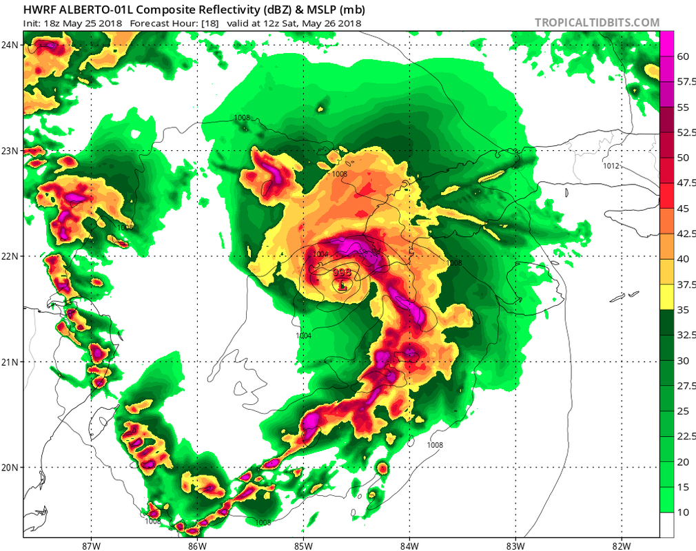
gatorcane wrote:18Z HWRF shifts significantly east with landfall over Western tip of Cuba:

Image


Just saying the blob looks to be near Cozumel looks like a angry monster!! LOL.
2 likes   

Sciencerocks
Category 5
Category 5
Posts: 9156
Age: 39
Joined: Thu Jul 06, 2017 1:51 am

Re: ATL: ALBERTO - Sub-Tropical Storm

#1243 Postby Sciencerocks » Fri May 25, 2018 6:06 pm

Image
0 likes   

User avatar
DestinHurricane
Category 4
Category 4
Posts: 935
Joined: Tue May 01, 2018 8:05 am
Location: New York, NY

Re: ATL: ALBERTO - Models

#1244 Postby DestinHurricane » Fri May 25, 2018 6:08 pm

18Z HMON lol Image
1 likes   
Michael 2018

psyclone
S2K Supporter
S2K Supporter
Posts: 4769
Joined: Wed Aug 24, 2005 9:04 pm
Location: palm harbor fl

Re: ATL: ALBERTO - Sub-Tropical Storm

#1245 Postby psyclone » Fri May 25, 2018 6:08 pm

That visible shows an impressive band of diurnal convection emerging off the north coast of cuba...part of which is lifting north toward the keys prompting special marine warnings.
0 likes   

bamajammer4eva
Category 4
Category 4
Posts: 907
Joined: Sun Apr 18, 2010 3:21 am
Location: Ozark, AL

Re: ATL: ALBERTO - Sub-Tropical Storm

#1246 Postby bamajammer4eva » Fri May 25, 2018 6:11 pm

Water temps are warmer than I expected this early in the summer

 https://twitter.com/VernonWSFA/status/1000151208433192960


0 likes   

User avatar
DestinHurricane
Category 4
Category 4
Posts: 935
Joined: Tue May 01, 2018 8:05 am
Location: New York, NY

ATL: ALBERTO - Sub-Tropical Storm

#1247 Postby DestinHurricane » Fri May 25, 2018 6:12 pm

lol look at 18Z HMON Image
0 likes   
Michael 2018

User avatar
GumboCane83
Tropical Wave
Tropical Wave
Posts: 9
Joined: Fri Oct 06, 2017 9:27 pm

Re: ATL: ALBERTO - Models

#1248 Postby GumboCane83 » Fri May 25, 2018 6:12 pm

Is it me but the majority of the ensemble models are taking this thing to Louisiana. Just asking what are the chances that the track moves more westward? We have a jambalaya festival lol. Asking for us Cajuns. :flag: :cheesy: :lol:
2 likes   

User avatar
tarheelprogrammer
S2K Supporter
S2K Supporter
Posts: 1793
Joined: Mon Mar 28, 2016 9:25 pm
Location: Raleigh, NC area (Garner, NC)

Re: ATL: ALBERTO - Models

#1249 Postby tarheelprogrammer » Fri May 25, 2018 6:14 pm

DestinHurricane wrote:18Z HMON lol Image


You never know. I laughed early last season at it. It proved me wrong. :double:
1 likes   
My posts are not official forecasts. They are just my opinion and may or may not be backed by sound meteorological data. They are NOT endorsed by any professional institution or storm2k.org. For official information, please refer to the NHC and NWS products.

Ian2401
Category 1
Category 1
Posts: 307
Joined: Thu Sep 14, 2017 5:55 pm
Location: Tallahassee, Florida
Contact:

Re: ATL: ALBERTO - Sub-Tropical Storm

#1250 Postby Ian2401 » Fri May 25, 2018 6:14 pm

DestinHurricane wrote:lol look at 18Z HMON Image

something tells me that might be a little overkill. just a little bit
1 likes   
B.S. Meteorology from Florida State '24 // Current M.S. Meteorology student at Florida State

Research Interests: Rapid Intensification, TC Climatology, TC Modeling

Consult the NHC for official information

jdjaguar
Category 2
Category 2
Posts: 551
Joined: Fri Aug 26, 2005 12:07 pm
Location: Jacksonville Beach, FL

Re: ATL: ALBERTO - Sub-Tropical Storm

#1251 Postby jdjaguar » Fri May 25, 2018 6:16 pm

Sciencerocks wrote:Image

To my admittedly layman eye, it appears a new COC is forming on a southwest- northeast axis anchored by Cozumel and the western tip of Cuba

This is further east than points resolved in the last model runs
0 likes   

User avatar
ronjon
Category 5
Category 5
Posts: 4822
Joined: Fri Aug 19, 2005 5:17 pm
Location: Hernando Beach, FL

Re: ATL: ALBERTO - Sub-Tropical Storm

#1252 Postby ronjon » Fri May 25, 2018 6:16 pm

Or is it just another vort spinning around the larger gyre? If it is a center reformation, ukie model was right.
0 likes   

jdjaguar
Category 2
Category 2
Posts: 551
Joined: Fri Aug 26, 2005 12:07 pm
Location: Jacksonville Beach, FL

Re: ATL: ALBERTO - Sub-Tropical Storm

#1253 Postby jdjaguar » Fri May 25, 2018 6:18 pm

Convection is also wrapping around this locale
0 likes   

User avatar
tarheelprogrammer
S2K Supporter
S2K Supporter
Posts: 1793
Joined: Mon Mar 28, 2016 9:25 pm
Location: Raleigh, NC area (Garner, NC)

Re: ATL: ALBERTO - Sub-Tropical Storm

#1254 Postby tarheelprogrammer » Fri May 25, 2018 6:18 pm

Ian2401 wrote:
DestinHurricane wrote:lol look at 18Z HMON Image

something tells me that might be a little overkill. just a little bit


HWRF is also stronger. Not that strong, but trending very badly IMHO.
0 likes   
My posts are not official forecasts. They are just my opinion and may or may not be backed by sound meteorological data. They are NOT endorsed by any professional institution or storm2k.org. For official information, please refer to the NHC and NWS products.

User avatar
AdamFirst
S2K Supporter
S2K Supporter
Posts: 2491
Age: 36
Joined: Thu Aug 14, 2008 10:54 am
Location: Port Saint Lucie, FL

Re: ATL: ALBERTO - Sub-Tropical Storm

#1255 Postby AdamFirst » Fri May 25, 2018 6:21 pm

Let us not forget how badly HWRF and HMON overdid intensity last year. Irma was a 200-knot category 8 deathcane on every single run between the two of them.

Considering how badly this storm looks right now, I would be surprised if it got north of 60 MPH even up near the central Gulf Coast.
4 likes   
Dolphins Marlins Canes Golden Panthers HEAT
Andrew 1992 - Irene 1999 - Frances 2004 - Jeanne 2004 - Wilma 2005 - Fay 2008 - Isaac 2012 - Matthew 2016 - Irma 2017 - Dorian 2019 - Ian 2022 - Nicole 2022 - Milton 2024

jdjaguar
Category 2
Category 2
Posts: 551
Joined: Fri Aug 26, 2005 12:07 pm
Location: Jacksonville Beach, FL

Re: ATL: ALBERTO - Sub-Tropical Storm

#1256 Postby jdjaguar » Fri May 25, 2018 6:23 pm

ronjon wrote:Or is it just another vort spinning around the larger gyre? If it is a center reformation, ukie model was right.

Could very well be, but is looks like it may subsume the small vort to the south, maybe relocate a bit WSW when all is said and done.

But to my eye this may very well be the dominant feature
1 likes   

psyclone
S2K Supporter
S2K Supporter
Posts: 4769
Joined: Wed Aug 24, 2005 9:04 pm
Location: palm harbor fl

Re: ATL: ALBERTO - Sub-Tropical Storm

#1257 Postby psyclone » Fri May 25, 2018 6:25 pm

We may have to await tonight's convective evolution for clues to any center reformations. You'd think we'd get some robust shower towers over the Yucatan channel during Dmax with that deep warm water..
1 likes   

User avatar
cycloneye
Admin
Admin
Posts: 145490
Age: 68
Joined: Thu Oct 10, 2002 10:54 am
Location: San Juan, Puerto Rico

Re: ATL: ALBERTO - Sub-Tropical Storm

#1258 Postby cycloneye » Fri May 25, 2018 6:25 pm

Note= I moved some posts that were related to model runs to the Alberto Models Thread.
1 likes   
Visit the Caribbean-Central America Weather Thread where you can find at first post web cams,radars
and observations from Caribbean basin members Click Here

stormreader

Re: ATL: ALBERTO - Sub-Tropical Storm

#1259 Postby stormreader » Fri May 25, 2018 6:32 pm

AdamFirst wrote:Let us not forget how badly HWRF and HMON overdid intensity last year. Irma was a 200-knot category 8 deathcane on every single run between the two of them.

Considering how badly this storm looks right now, I would be surprised if it got north of 60 MPH even up near the central Gulf Coast.

Be careful!
1 likes   

Alyono
Professional-Met
Professional-Met
Posts: 6961
Joined: Fri Apr 26, 2013 3:52 pm
Location: Texas Coast

Re: ATL: ALBERTO - Models

#1260 Postby Alyono » Fri May 25, 2018 6:33 pm

some need to take a step back and think through the dynamics and thermodynamics of what will happen.

This is expected to get under the upper low. Have we all forgotten how many times we have seen development over 20-22C waters when the surface low moves under the upper low? This time, we will be over ~28C waters. The lapse rates should be even steeper than we see with the late season North Atlantic as well as TCs in the Mediterranean
10 likes   


Return to “2018”

Who is online

Users browsing this forum: No registered users and 4 guests