
Lets see if the AF recon finds those 100 knot fl level winds the NOAA recon recorded.
025500 2310N 08500W 6954 03001 9889 +079 +079 173084 090 066 028 00
ATL: MICHAEL - Post-Tropical - Discussion
Moderator: S2k Moderators

Re: ATL: MICHAEL - Hurricane - Discussion
NDG wrote:Lets see if the AF recon finds those 100 knot fl level winds the NOAA recon recorded.
025500 2310N 08500W 6954 03001 9889 +079 +079 173084 090 066 028 00
AF often finds higher winds (no idea why that is though) so the next pass will be interesting.
Edit: 90kt, spoke too soon.
Last edited by Hammy on Mon Oct 08, 2018 10:05 pm, edited 1 time in total.
0 likes
The above post is not official and should not be used as such. It is the opinion of the poster and may or may not be backed by sound meteorological data. It is not endorsed by any professional institution or storm2k.org. For official information, please refer to the NHC and NWS products.

Re: ATL: MICHAEL - Hurricane - Discussion
From NHC Forecast Advisory #10
Michael's steady intensification over the past 48 hours in the face of 20-kt westerly shear defies traditional logic. Either the shear calculations are unrepresentative or Michael has become more inertially stable due to its large eye and large outer wind field, making it more shear resistant.
2 likes
Re: ATL: MICHAEL - Hurricane - Discussion
This is interesting from the latest discussion.
Michael's steady intensification over the past 48 hours in the face
of 20-kt westerly shear defies traditional logic. Either the shear
calculations are unrepresentative or Michael has become more
inertially stable due to its large eye and large outer wind field,
making it more shear resistant. Having said that, all of the model
guidance calls for the shear to decrease to around 10 kt or less by
36 hours, which argues for at least steady intensification during
that time given that Michael will be moving over warm SSTs of
28.5C-29C, which are about 1-2 deg C above average for this time of
the year.
2 likes
-
supercane4867
- Category 5

- Posts: 4966
- Joined: Wed Nov 14, 2012 10:43 am
Re: ATL: MICHAEL - Hurricane - Discussion
According to 11PM NHC discussion, Michael continues to defy common sense and logic...
5 likes
-
CrazyC83
- Professional-Met

- Posts: 34316
- Joined: Tue Mar 07, 2006 11:57 pm
- Location: Deep South, for the first time!
Re: ATL: MICHAEL - Hurricane - Discussion
Didn't Opal go through decent shear and get well organized, before it bombed out overnight down to 916mb?
3 likes
-
meriland29

- Category 2

- Posts: 770
- Joined: Thu Aug 03, 2017 11:05 am
Re: ATL: MICHAEL - Hurricane - Discussion
I just want to quote this very interesting bit off the latest NHC advisory../
"Michael's steady intensification over the past 48 hours in the face
of 20-kt westerly shear defies traditional logic. Either the shear
calculations are unrepresentative or Michael has become more
inertially stable due to its large eye and large outer wind field,
making it more shear resistant."
Interesting wordage there...
2 likes
Re: ATL: MICHAEL - Hurricane - Discussion
AF recon didn't find the 100 knot flight level winds but finds the pressure a little lower than the last pass.
23.1N & 85.44W
030230 2306N 08526W 6967 02909 9694 +168 +073 107006 006 024 000 00
23.1N & 85.44W
030230 2306N 08526W 6967 02909 9694 +168 +073 107006 006 024 000 00
0 likes
-
northjaxpro

- S2K Supporter

- Posts: 8900
- Joined: Mon Sep 27, 2010 11:21 am
- Location: Jacksonville, FL
Re: ATL: MICHAEL - Hurricane - Discussion
Pressure down to 969 mb
2 likes
NEVER, EVER SAY NEVER in the tropics and weather in general, and most importantly, with life itself!!
________________________________________________________________________________________
Fay 2008 Beryl 2012 Debby 2012 Colin 2016 Hermine 2016 Julia 2016 Matthew 2016 Irma 2017 Dorian 2019
________________________________________________________________________________________
Fay 2008 Beryl 2012 Debby 2012 Colin 2016 Hermine 2016 Julia 2016 Matthew 2016 Irma 2017 Dorian 2019
-
EquusStorm
- Category 5
- Posts: 1649
- Age: 35
- Joined: Thu Nov 07, 2013 1:04 pm
- Location: Jasper, AL
- Contact:
Re: ATL: MICHAEL - Hurricane - Discussion
This is about the time I refresh the page every couple of minutes desperate for more info, but there's really not much more out there right now yet
1 likes
Colors of lost purpose on the canvas of irrelevance
Not a meteorologist, in fact more of an idiot than anything. You should probably check with the NHC or a local NWS office for official information.
Not a meteorologist, in fact more of an idiot than anything. You should probably check with the NHC or a local NWS office for official information.
-
FLpanhandle91

- Category 5
- Posts: 1039
- Age: 34
- Joined: Mon Sep 13, 2010 3:50 pm
- Location: Fort Walton Beach, FL
Re: ATL: MICHAEL - Hurricane - Discussion
Hot towers firing southeast of the center now. Could be wheels up for rapid intensification.
2 likes
Re: ATL: MICHAEL - Hurricane - Discussion
Just an FYI on how the forecast track has been left biased in the short term, as if the low level circulation keeps wanting to chase the convection and MLC being pushed to the right by the mod shear.

0 likes
-
eastcoastFL

- Category 5
- Posts: 3996
- Age: 44
- Joined: Thu Apr 12, 2007 12:29 pm
- Location: Palm City, FL
Re: ATL: MICHAEL - Hurricane - Discussion
meriland29 wrote:I just want to quote this very interesting bit off the latest NHC advisory../
"Michael's steady intensification over the past 48 hours in the face
of 20-kt westerly shear defies traditional logic. Either the shear
calculations are unrepresentative or Michael has become more
inertially stable due to its large eye and large outer wind field,
making it more shear resistant."
Interesting wordage there...
I found that interesting also. Imagine canes start evolving to become shear resistant?
5 likes
Personal Forecast Disclaimer:
The posts in this forum are NOT official forecast and should not be used as such. They are just the opinion of the poster and may or may not be backed by sound meteorological data. They are NOT endorsed by any professional institution or storm2k.org. For official information, please refer to the NHC and NWS products.
The posts in this forum are NOT official forecast and should not be used as such. They are just the opinion of the poster and may or may not be backed by sound meteorological data. They are NOT endorsed by any professional institution or storm2k.org. For official information, please refer to the NHC and NWS products.
-
cheezyWXguy

- Category 5
- Posts: 6282
- Joined: Mon Feb 13, 2006 12:29 am
- Location: Dallas, TX
Re: ATL: MICHAEL - Hurricane - Discussion
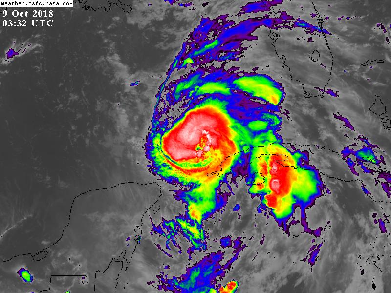
SE quadrant just lit up with more convection in the last 15-20 min. Michael is on the verge of closing off ring (albeit still a bit misshapen) of -75C tops
0 likes


Re: ATL: MICHAEL - Hurricane - Discussion
EquusStorm wrote:This is about the time I refresh the page every couple of minutes desperate for more info, but there's really not much more out there right now yet
Aside what from what recon is finding there isn't much to post yet. I suspect a lot of activity here in the morning and tomorrow.
Michael has definitely fired off strong convection this evening with cold cloud tops. As with any storm if the core can really get it together, getting to a major shouldn't be a problem. Shear seems to be the biggest inhibitor but thus far has not been a problem for the storm somehow.

3 likes
The above post and any post by Ntxw is NOT an official forecast and should not be used as such. It is just the opinion of the poster and may or may not be backed by sound meteorological data. It is NOT endorsed by any professional institution including Storm2k. For official information, please refer to NWS products.
Help support Storm2K!


-
tropicwatch

- Category 5
- Posts: 3427
- Age: 62
- Joined: Sat Jun 02, 2007 10:01 am
- Location: The Villages, Florida
- Contact:
Re: ATL: MICHAEL - Hurricane - Discussion
Actually able to see Michael's eye.
1 likes
Tropicwatch
Agnes 72', Eloise 75, Elena 85', Kate 85', Charley 86', Florence 88', Beryl 94', Dean 95', Erin 95', Opal 95', Earl 98', Georges 98', Ivan 2004', Arlene 2005', Dennis 2005', Ida 2009' Debby 2012' Irma 2017' Michael 2018'
Agnes 72', Eloise 75, Elena 85', Kate 85', Charley 86', Florence 88', Beryl 94', Dean 95', Erin 95', Opal 95', Earl 98', Georges 98', Ivan 2004', Arlene 2005', Dennis 2005', Ida 2009' Debby 2012' Irma 2017' Michael 2018'
-
cheezyWXguy
- Category 5
- Posts: 6282
- Joined: Mon Feb 13, 2006 12:29 am
- Location: Dallas, TX
Re: ATL: MICHAEL - Hurricane - Discussion
cheezyWXguy wrote:SE quadrant just lit up with more convection in the last 15-20 min. Michael is on the verge of closing off ring (albeit still a bit misshapen) of -75C tops
Actually as of now, its cranking out a ring of -80C which is about 2/3 complete now. Definitely strengthening now, if it keeps this up pressure and wind should start to respond in the next couple hours.
0 likes
-
SeaBrz_FL

- S2K Supporter
- Posts: 472
- Age: 70
- Joined: Thu Aug 12, 2004 10:47 am
- Location: Cape Canaveral, FL
Re: ATL: MICHAEL - Hurricane - Discussion
EquusStorm wrote:This is about the time I refresh the page every couple of minutes desperate for more info, but there's really not much more out there right now yet
Yep, know that feeling well. A four-hour sleep shift followed by an hour to check the web, repeat, repeat.
2 likes
-
meriland29
- Category 2
- Posts: 770
- Joined: Thu Aug 03, 2017 11:05 am
Re: ATL: MICHAEL - Hurricane - Discussion
eastcoastFL wrote:meriland29 wrote:I just want to quote this very interesting bit off the latest NHC advisory../
"Michael's steady intensification over the past 48 hours in the face
of 20-kt westerly shear defies traditional logic. Either the shear
calculations are unrepresentative or Michael has become more
inertially stable due to its large eye and large outer wind field,
making it more shear resistant."
Interesting wordage there...
I found that interesting also. Imagine canes start evolving to become shear resistant?
Like viruses? Lol
4 likes
Who is online
Users browsing this forum: No registered users and 70 guests