ATL: MICHAEL - Post-Tropical - Discussion
Moderator: S2k Moderators
-
TheStormExpert

Re: ATL: MICHAEL - Hurricane - Discussion
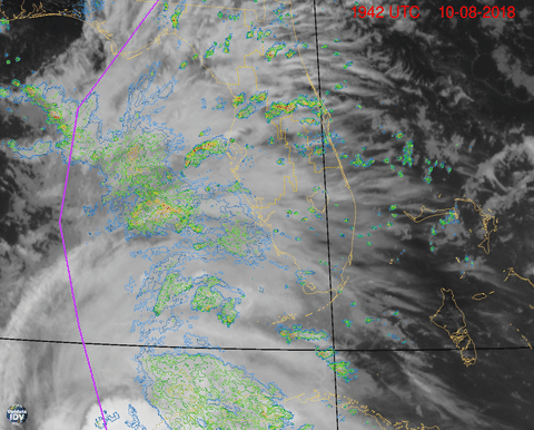
Kermit measuring a 39 mm/hr rain-rate cell, in the clear, east of the CoC.
0 likes

-
tropicwatch

- Category 5

- Posts: 3427
- Age: 62
- Joined: Sat Jun 02, 2007 10:01 am
- Location: The Villages, Florida
- Contact:
Re: ATL: MICHAEL - Hurricane - Discussion
BobHarlem wrote:Dry air still along the west side:
Does not appear to be hindering Michael and the outflow appears to be expanding.
1 likes
Tropicwatch
Agnes 72', Eloise 75, Elena 85', Kate 85', Charley 86', Florence 88', Beryl 94', Dean 95', Erin 95', Opal 95', Earl 98', Georges 98', Ivan 2004', Arlene 2005', Dennis 2005', Ida 2009' Debby 2012' Irma 2017' Michael 2018'
Agnes 72', Eloise 75, Elena 85', Kate 85', Charley 86', Florence 88', Beryl 94', Dean 95', Erin 95', Opal 95', Earl 98', Georges 98', Ivan 2004', Arlene 2005', Dennis 2005', Ida 2009' Debby 2012' Irma 2017' Michael 2018'
-
Hypercane_Kyle

- Category 5
- Posts: 3465
- Joined: Sat Mar 07, 2015 7:58 pm
- Location: Cape Canaveral, FL
Re: ATL: MICHAEL - Hurricane - Discussion
Looks to me Michael's about to drop a massive eye.
0 likes
My posts are my own personal opinion, defer to the National Hurricane Center (NHC) and other NOAA products for decision making during hurricane season.
Re: ATL: MICHAEL - Hurricane - Discussion
With shear starting to crash the dry air should not be a huge issue.
1 likes
-
tolakram
- Admin

- Posts: 20186
- Age: 62
- Joined: Sun Aug 27, 2006 8:23 pm
- Location: Florence, KY (name is Mark)
Re: ATL: MICHAEL - Hurricane - Discussion
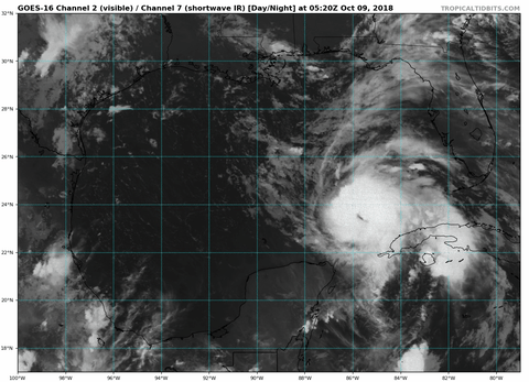
Long IR loop. Much more symmetrical this morning.
https://weather.cod.edu/satrad/exper/?parms=regional-gulf-13-200-1-100-1&checked=map&colorbar=undefined
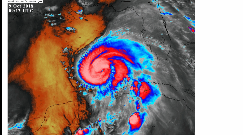
NT Microphysics makes it easier to locate the center.
https://weather.cod.edu/satrad/exper/?parms=regional-gulf-ntmicro-200-1-10-1&checked=map&colorbar=undefined
https://weather.cod.edu/satrad/exper/?parms=regional-gulf-13-200-1-100-1&checked=map&colorbar=undefined
NT Microphysics makes it easier to locate the center.
https://weather.cod.edu/satrad/exper/?parms=regional-gulf-ntmicro-200-1-10-1&checked=map&colorbar=undefined
1 likes
M a r k
- - - - -
Join us in chat: Storm2K Chatroom Invite. Android and IOS apps also available.
The posts in this forum are NOT official forecasts and should not be used as such. Posts are NOT endorsed by any professional institution or STORM2K.org. For official information and forecasts, please refer to NHC and NWS products.
-
FLpanhandle91

- Category 5
- Posts: 1039
- Age: 34
- Joined: Mon Sep 13, 2010 3:50 pm
- Location: Fort Walton Beach, FL
Re: ATL: MICHAEL - Hurricane - Discussion
89 knot unflagged SFMR.
103630 2431N 08549W 7496 02281 9724 +163 //// 161050 055 089 010 01
Pressure around 969.
103630 2431N 08549W 7496 02281 9724 +163 //// 161050 055 089 010 01
Pressure around 969.
0 likes
-
Slughitter3
- Tropical Depression

- Posts: 54
- Age: 36
- Joined: Wed Jul 10, 2013 1:16 pm
- Location: Huntingtown, MD
Re: ATL: MICHAEL - Hurricane - Discussion
Good Morning All,
I Hope to be on here quite a bit today. I haven't taken a peak since about 6PM EDT and....what a show! Shortwave IR is showing a massive eye forming with a little bit of mesovorts still spinning around it. Looks to be firing on all cylinders.

I Hope to be on here quite a bit today. I haven't taken a peak since about 6PM EDT and....what a show! Shortwave IR is showing a massive eye forming with a little bit of mesovorts still spinning around it. Looks to be firing on all cylinders.
1 likes
I'm a weather-loving Coastie.
This post is only an opinion not a forecast. Please refer to the NHC and local NWS offices for forecasts.
Shawn
This post is only an opinion not a forecast. Please refer to the NHC and local NWS offices for forecasts.
Shawn
-
BensonTCwatcher

- Category 5
- Posts: 1050
- Joined: Sat Aug 28, 2004 10:11 pm
- Location: Southport NC
Re: ATL: MICHAEL - Hurricane - Discussion
Looks like the eyewall structure is coming together. Convection firing almost all way around on E and SE side of the inner core. If it fills in the SW side, we'll see the pressure drop and winds increase as it will be able to hold off the dry air. Looks easily to be an intensifying hurricane at landfall- always bad. Prayers for the folks there.
2 likes

Re: ATL: MICHAEL - Hurricane - Discussion
89kts SFMR and flight level winds multiple times between 95-100kts. Will almost certainly be upgraded to 85kts, could go to 90kts...
0 likes
Personal Forecast Disclaimer:
The posts in this forum are NOT official forecast and should not be used as such. They are just the opinion of the poster and may or may not be backed by sound meteorological data. They are NOT endorsed by any professional institution or storm2k.org. For official information, please refer to the NHC and NWS products
The posts in this forum are NOT official forecast and should not be used as such. They are just the opinion of the poster and may or may not be backed by sound meteorological data. They are NOT endorsed by any professional institution or storm2k.org. For official information, please refer to the NHC and NWS products
-
jlauderdal
- S2K Supporter

- Posts: 7240
- Joined: Wed May 19, 2004 5:46 am
- Location: NE Fort Lauderdale
- Contact:
Re: ATL: MICHAEL - Hurricane - Discussion
GCANE wrote:I don't think I have seen this many recons in the air before.
irma had multiple planes up at any given time, they threw the book at it and it still went farther west than they thought it would
3 likes
-
Hypercane_Kyle
- Category 5
- Posts: 3465
- Joined: Sat Mar 07, 2015 7:58 pm
- Location: Cape Canaveral, FL
Re: ATL: MICHAEL - Hurricane - Discussion
Recon suggests Category 2 status. FL winds 100 knots, SFMR 89 knots, ESLP ~968.7mb.
2 likes
My posts are my own personal opinion, defer to the National Hurricane Center (NHC) and other NOAA products for decision making during hurricane season.

Re: ATL: MICHAEL - Hurricane - Discussion
Hypercane_Kyle wrote:Looks to me Michael's about to drop a massive eye.
A large eye requires a lot more inflow and there is a somewhat dry environment to the west.
Lets hope Michael is like the guy that got into the habit of eating a 16" Papa John's pizza every night instead of the 8" size that met his metabolic caloric needs.
By the time he is ready to retire in Florida he will need a nursing home.
1 likes

Re: ATL: MICHAEL - Hurricane - Discussion
Looks like Michael is starting to strengthen again this morning, NOAA's latest pass on the eastern quadrant.
103500 2430N 08542W 7511 02308 9791 +142 //// 158096 098 085 068 01
103530 2430N 08544W 7493 02304 9755 +148 //// 162091 100 086 054 01
103600 2430N 08546W 7436 02357 9733 +158 //// 167060 067 084 024 01
103630 2431N 08549W 7496 02281 9724 +163 //// 161050 055 089 010 01
103500 2430N 08542W 7511 02308 9791 +142 //// 158096 098 085 068 01
103530 2430N 08544W 7493 02304 9755 +148 //// 162091 100 086 054 01
103600 2430N 08546W 7436 02357 9733 +158 //// 167060 067 084 024 01
103630 2431N 08549W 7496 02281 9724 +163 //// 161050 055 089 010 01
0 likes
-
PSUHiker31
- Tropical Storm

- Posts: 114
- Joined: Tue Oct 03, 2017 2:36 pm
Re: ATL: MICHAEL - Hurricane - Discussion
The satellite appearance is looking much better with -80 C wrapped all the way around. Recon appears to support 100-105 mph.
0 likes
-
northjaxpro

- S2K Supporter
- Posts: 8900
- Joined: Mon Sep 27, 2010 11:21 am
- Location: Jacksonville, FL
Re: ATL: MICHAEL - Hurricane - Discussion
Definitely ramping up now with intensity.
0 likes
NEVER, EVER SAY NEVER in the tropics and weather in general, and most importantly, with life itself!!
________________________________________________________________________________________
Fay 2008 Beryl 2012 Debby 2012 Colin 2016 Hermine 2016 Julia 2016 Matthew 2016 Irma 2017 Dorian 2019
________________________________________________________________________________________
Fay 2008 Beryl 2012 Debby 2012 Colin 2016 Hermine 2016 Julia 2016 Matthew 2016 Irma 2017 Dorian 2019
-
p1nheadlarry

- Category 2

- Posts: 672
- Age: 34
- Joined: Wed Jan 29, 2014 2:42 pm
- Location: SR County FL
Re: ATL: MICHAEL - Hurricane - Discussion
GCANE wrote:Michael will be moving into a moderately strong Theta-E ridge to the NW.
Very close to the Loop Current.
2 strong conducive factors for intensification.
http://i68.tinypic.com/28a7ynd.png
Was worried about the CI in the Gulf
0 likes
--;->#GoNoles--;->.
-
BYG Jacob
Who is online
Users browsing this forum: No registered users and 103 guests