Thank you for this. What is the dark blue line?
ATL: FLORENCE - Models
Moderator: S2k Moderators
-
sittingduck

- S2K Supporter

- Posts: 112
- Joined: Mon Aug 13, 2007 3:16 pm
- Location: venice florida
Re: ATL: FLORENCE - Models
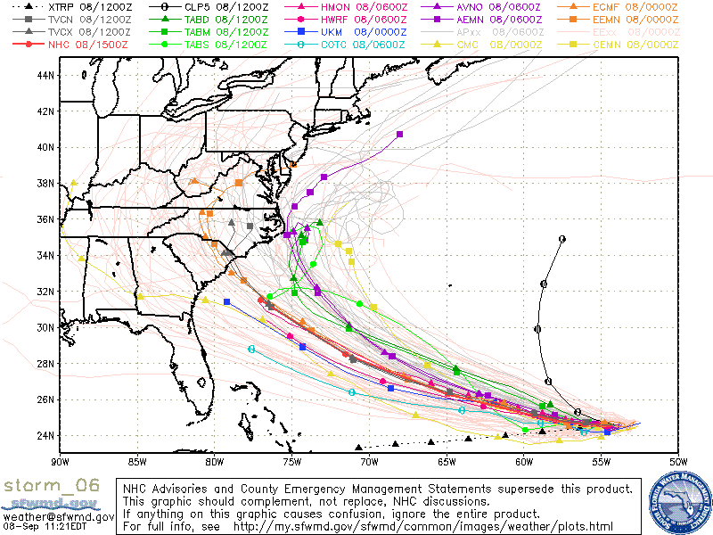
[quote="wxman57"]Here's a plot of all the better models (removed the non-dynamic TAB & climo & NOGAPS). Purple lines are EC ensembles. Yellow are Canadian 00Z ensembles, Green are 06Z GFS ensembles. Reddish line east of Hatteras is GFS ensembles mean. Purplish line into the SC/NC border is the consensus model TVCN. Looks like Houston isn't out of the woods for a Florence landfall, as one EC member has it coming here. 
Thank you for this. What is the dark blue line?
Thank you for this. What is the dark blue line?
2 likes
-
tarheelprogrammer

- S2K Supporter
- Posts: 1793
- Joined: Mon Mar 28, 2016 9:25 pm
- Location: Raleigh, NC area (Garner, NC)
Re: ATL: FLORENCE - Models
sittingduck wrote:wxman57 wrote:Here's a plot of all the better models (removed the non-dynamic TAB & climo & NOGAPS). Purple lines are EC ensembles. Yellow are Canadian 00Z ensembles, Green are 06Z GFS ensembles. Reddish line east of Hatteras is GFS ensembles mean. Purplish line into the SC/NC border is the consensus model TVCN. Looks like Houston isn't out of the woods for a Florence landfall, as one EC member has it coming here.
Thank you for this. What is the dark blue line?
UKMET
1 likes
My posts are not official forecasts. They are just my opinion and may or may not be backed by sound meteorological data. They are NOT endorsed by any professional institution or storm2k.org. For official information, please refer to the NHC and NWS products.

Re: ATL: FLORENCE - Models
Hurricaneman wrote:ronjon wrote:From NHC 11 am disc:
After 36 hours,
the most notable change in the models was a northeastward shift in
the 06Z GFS. However, that run appears to be an outlier from the
rest of the dynamical models, and its trend opposes the slight
westward shift noted in the HCCA and FSSE aids. The updated NHC
track forecast is therefore very close to or slightly west of the
previous forecast on days 4 and 5. The exact path of Florence as it
approaches the southeastern U.S. coastline will depend heavily on
the position and strength of the blocking high pressure that is
expected to develop north of Bermuda and extend westward over the
eastern U.S., and so far there has not been much more clarity on
those important details.
It’s rare for the NHC to discount any models but it looks like they discounted the GFS
I've never seen that. I was hoping that the 06Z run may have been a trend north and east that the other models would pick up on.
0 likes
-
SunnyThoughts
- Category 5

- Posts: 2263
- Joined: Wed Jul 09, 2003 12:42 pm
- Location: Pensacola, Florida
Re: ATL: FLORENCE - Models
Sitting here considering a 70 mile wide eye...unimaginable. Pensacola, Fla is about 60 miles from Mobile, Ala. Just trying to imagine how 2 cities that far apart could fit inside an eye of a hurricane at the same time. Im sure many of you up in SC and NC are considering that as well, just not as familiar with cities there myself other than Charleston and myrtle beach maybe?
0 likes
-
Blown Away

- S2K Supporter
- Posts: 10253
- Joined: Wed May 26, 2004 6:17 am
Re: ATL: FLORENCE - Models

12z GFS.. SW of 06z at 48 hrs...
0 likes
Hurricane Eye Experience: David 79, Irene 99, Frances 04, Jeanne 04, Wilma 05… Hurricane Brush Experience: Andrew 92, Erin 95, Floyd 99, Matthew 16, Irma 17, Ian 22, Nicole 22…
-
tolakram
- Admin

- Posts: 20185
- Age: 62
- Joined: Sun Aug 27, 2006 8:23 pm
- Location: Florence, KY (name is Mark)
Re: ATL: FLORENCE - Models
12Z so far

0 likes
M a r k
- - - - -
Join us in chat: Storm2K Chatroom Invite. Android and IOS apps also available.
The posts in this forum are NOT official forecasts and should not be used as such. Posts are NOT endorsed by any professional institution or STORM2K.org. For official information and forecasts, please refer to NHC and NWS products.

Re: ATL: FLORENCE - Models
FWIW, the 12Z discount model is running. Perhaps slightly S if that at 48hrs.
0 likes
-
Hurricane Andrew

- S2K Supporter
- Posts: 1891
- Age: 27
- Joined: Sun May 23, 2010 2:53 pm
- Location: KS
Re: ATL: FLORENCE - Models
Ridging a little stronger through Hr 60, storm slightly south. Quicker intensification from D1-D2 as well, reflective of realtime trends.
1 likes
The Enthusiast
NREMT-AEMT, WX nerd
Irene '11, Sandy '12, Irma '17 (SAR)
"Hard to think we were born to live this way..." -Wage War
-
Blown Away
- S2K Supporter
- Posts: 10253
- Joined: Wed May 26, 2004 6:17 am
Re: ATL: FLORENCE - Models
12z GFS... S of 06z at 66 hrs... Ridging stronger...
Last edited by Blown Away on Sat Sep 08, 2018 10:52 am, edited 1 time in total.
0 likes
Hurricane Eye Experience: David 79, Irene 99, Frances 04, Jeanne 04, Wilma 05… Hurricane Brush Experience: Andrew 92, Erin 95, Floyd 99, Matthew 16, Irma 17, Ian 22, Nicole 22…
-
tolakram
- Admin
- Posts: 20185
- Age: 62
- Joined: Sun Aug 27, 2006 8:23 pm
- Location: Florence, KY (name is Mark)
Re: ATL: FLORENCE - Models
Trend. Remember, on this normalized 500mb chart, the colors represent anomalies, not pressures, and should be ignored. Only the 500mb lines count. 

0 likes
M a r k
- - - - -
Join us in chat: Storm2K Chatroom Invite. Android and IOS apps also available.
The posts in this forum are NOT official forecasts and should not be used as such. Posts are NOT endorsed by any professional institution or STORM2K.org. For official information and forecasts, please refer to NHC and NWS products.
- - - - -
Join us in chat: Storm2K Chatroom Invite. Android and IOS apps also available.
The posts in this forum are NOT official forecasts and should not be used as such. Posts are NOT endorsed by any professional institution or STORM2K.org. For official information and forecasts, please refer to NHC and NWS products.
-
Blown Away
- S2K Supporter
- Posts: 10253
- Joined: Wed May 26, 2004 6:17 am
Re: ATL: FLORENCE - Models

Up to 78 hrs... Thumb appears again...
Last edited by Blown Away on Sat Sep 08, 2018 10:57 am, edited 1 time in total.
0 likes
Hurricane Eye Experience: David 79, Irene 99, Frances 04, Jeanne 04, Wilma 05… Hurricane Brush Experience: Andrew 92, Erin 95, Floyd 99, Matthew 16, Irma 17, Ian 22, Nicole 22…
-
floridasun78
- Category 5
- Posts: 3755
- Joined: Sun May 17, 2009 10:16 pm
- Location: miami fl
Re: ATL: FLORENCE - Models
this from miami weather office TC FLORENCE IMPACTS: Quite a bit early to discuss impacts from TC Florence as the track is uncertain at this time. However if the current track holds or shifts southward, swell will begin to impact the east coast of Florida beginning late Tuesday and especially Wednesday into next weekend. Expect a high risk of rip
0 likes
-
jlauderdal
- S2K Supporter
- Posts: 7240
- Joined: Wed May 19, 2004 5:46 am
- Location: NE Fort Lauderdale
- Contact:
Re: RE: Re: ATL: FLORENCE - Models
The good old thumb ridge in playBlown Away wrote:
Up to 78 hrs... Thumb appears again...
0 likes
-
tarheelprogrammer
- S2K Supporter
- Posts: 1793
- Joined: Mon Mar 28, 2016 9:25 pm
- Location: Raleigh, NC area (Garner, NC)
Re: ATL: FLORENCE - Models
Hour 90-96, was that a NNW movement?
0 likes
My posts are not official forecasts. They are just my opinion and may or may not be backed by sound meteorological data. They are NOT endorsed by any professional institution or storm2k.org. For official information, please refer to the NHC and NWS products.
-
Blown Away
- S2K Supporter
- Posts: 10253
- Joined: Wed May 26, 2004 6:17 am
Re: ATL: FLORENCE - Models
tarheelprogrammer wrote:Hour 90-96, was that a NNW movement?
12z GFS... 96 hrs... Slightly SE of 06z... Moving WNW
0 likes
Hurricane Eye Experience: David 79, Irene 99, Frances 04, Jeanne 04, Wilma 05… Hurricane Brush Experience: Andrew 92, Erin 95, Floyd 99, Matthew 16, Irma 17, Ian 22, Nicole 22…

Re: ATL: FLORENCE - Models
Exact same spot at hr 102
Last edited by storm4u on Sat Sep 08, 2018 11:03 am, edited 1 time in total.
0 likes
Re: ATL: FLORENCE - Models
Blown Away wrote:tarheelprogrammer wrote:Hour 90-96, was that a NNW movement?
12z GFS... 96 hrs... Slightly SE of 06z... Moving WNW
Looks like it's headed to the OBX again.
1 likes
-
Blown Away
- S2K Supporter
- Posts: 10253
- Joined: Wed May 26, 2004 6:17 am
Re: ATL: FLORENCE - Models
storm4u wrote:Exact the same spot at hr 102
May miss E again...
1 likes
Hurricane Eye Experience: David 79, Irene 99, Frances 04, Jeanne 04, Wilma 05… Hurricane Brush Experience: Andrew 92, Erin 95, Floyd 99, Matthew 16, Irma 17, Ian 22, Nicole 22…
-
SouthFLTropics

- Category 5
- Posts: 4258
- Age: 50
- Joined: Thu Aug 14, 2003 8:04 am
- Location: Port St. Lucie, Florida
Re: ATL: FLORENCE - Models
GFS is bound and determined to turn this North.
3 likes
Fourth Generation Florida Native
Personal Storm History: David 79, Andrew 92, Erin 95, Floyd 99, Irene 99, Frances 04, Jeanne 04, Wilma 05, Matthew 16, Irma 17, Ian 22, Nicole 22, Milton 24
Personal Storm History: David 79, Andrew 92, Erin 95, Floyd 99, Irene 99, Frances 04, Jeanne 04, Wilma 05, Matthew 16, Irma 17, Ian 22, Nicole 22, Milton 24
Who is online
Users browsing this forum: No registered users and 160 guests