
I just calculated how far TS force & hurricane force winds are from the eye based on the latest recon pass.
On the NW quadrant TS force winds reach out 126 miles from the eye, Hurricane force winds reach out 40 miles from eye.
On the SE quadrant TS force winds reach out 100 miles from the eye, Hurricane force winds reach out 38 miles from the eye.
So in another words at minimum TS force winds cover approximately 226 miles in diameter from NW to SE and hurricane force winds approximately 78 miles in diameter from NW to SE.
Edit: Just want to clarify that these were based off of SFMR not from Flight level winds.
ATL: FLORENCE - Post-Tropical - Discussion
Moderator: S2k Moderators
Re: ATL: FLORENCE - Hurricane - Discussion
Last edited by NDG on Tue Sep 11, 2018 6:47 am, edited 1 time in total.
1 likes
-
wxman57

- Moderator-Pro Met

- Posts: 23170
- Age: 68
- Joined: Sat Jun 21, 2003 8:06 pm
- Location: Houston, TX (southwest)
Re: ATL: FLORENCE - Hurricane - Discussion
NDG wrote:I just calculated how far TS force & hurricane force winds are from the eye based on the latest recon pass.
On the NW quadrant TS force winds reach out 126 miles from the eye, Hurricane force winds reach out 40 miles from eye.
On the SE quadrant TS force winds reach out 100 miles from the eye, Hurricane force winds reach out 38 miles from the eye.
So in another words at minimum TS force winds cover approximately 226 miles in diameter from NW to SE and hurricane force winds approximately 78 miles in diameter from NW to SE.
With the new outer eye over 50 miles in diameter, I'd say hurricane force winds may now extend out to 60-70 miles from the center. That will decrease today as the eye contracts.
1 likes
Re: ATL: FLORENCE - Hurricane - Discussion
Hard to tell with that jagged eye, but it looks like it’s taking on a slightly more northerly component than earlier. Still WNW, but gaining a bit more latitude than it has been.
0 likes
-
supercane4867
- Category 5

- Posts: 4966
- Joined: Wed Nov 14, 2012 10:43 am
Re: ATL: FLORENCE - Hurricane - Discussion
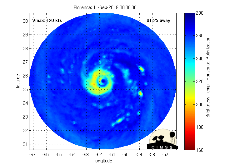
Latest microwave pass shows EWRC is near completion with no signs of inner eyewall left

1 likes
-
cycloneye

- Admin

- Posts: 149171
- Age: 69
- Joined: Thu Oct 10, 2002 10:54 am
- Location: San Juan, Puerto Rico
Re: ATL: FLORENCE - Hurricane - Discussion
0 likes
Visit the Caribbean-Central America Weather Thread where you can find at first post web cams,radars
and observations from Caribbean basin members Click Here
and observations from Caribbean basin members Click Here
-
PavelGaborik10
- Category 1

- Posts: 472
- Joined: Tue Sep 04, 2018 3:23 pm
Re: ATL: FLORENCE - Hurricane - Discussion
supercane4867 wrote:Latest microwave pass shows EWRC is near completion with no signs of inner eyewall left
https://i.imgur.com/xOb5WMq.jpg
Seems to be having a tough time closing it off to it's N. Hopefully this continues.
0 likes
-
Hurricane Mike
- Category 2

- Posts: 675
- Joined: Tue Apr 10, 2018 7:44 am
Re: ATL: FLORENCE - Hurricane - Discussion
Not good, looks to be expanding in size and becoming a much larger major hurricane. Once that new eye pops out, we will likely see more re-strengthening.
1 likes

-
FLpanhandle91

- Category 5
- Posts: 1039
- Age: 34
- Joined: Mon Sep 13, 2010 3:50 pm
- Location: Fort Walton Beach, FL
Re: ATL: FLORENCE - Hurricane - Discussion
Recon found 143kt flight level winds and evidence of a fairly large eye forming.
1 likes
-
dukeblue219
- S2K Supporter

- Posts: 556
- Joined: Fri Sep 30, 2016 3:52 pm
Re: ATL: FLORENCE - Hurricane - Discussion
Recon is just reaching the center now, with the lowest pressure so far 950.8 and 138kt flight level winds. Peak gust 143kt.
0 likes
Re: ATL: FLORENCE - Hurricane - Discussion
can't find my link to raw recon data. can you post the link please?
dukeblue219 wrote:Recon is just reaching the center now, with the lowest pressure so far 950.8 and 138kt flight level winds. Peak gust 143kt.
0 likes
-
dukeblue219
- S2K Supporter
- Posts: 556
- Joined: Fri Sep 30, 2016 3:52 pm
Re: ATL: FLORENCE - Hurricane - Discussion
Andy_L wrote:can't find my link to raw recon data. can you post the link please?
I use http://tropicalatlantic.com/recon/recon.cgi but there are others
1 likes
-
meriland29

- Category 2
- Posts: 770
- Joined: Thu Aug 03, 2017 11:05 am


Re: ATL: FLORENCE - Hurricane - Discussion
Rain rate also picking up
65 mm/hr in the clear.
The kind of intensity that can drive it to a Cat 5.
65 mm/hr in the clear.
The kind of intensity that can drive it to a Cat 5.
1 likes
-
meriland29
- Category 2
- Posts: 770
- Joined: Thu Aug 03, 2017 11:05 am
Re: ATL: FLORENCE - Hurricane - Discussion
Her northern bit looks a little behind in terms of gaining up on that convection. Possible problems from ERC?
0 likes
-
cycloneye
- Admin
- Posts: 149171
- Age: 69
- Joined: Thu Oct 10, 2002 10:54 am
- Location: San Juan, Puerto Rico
Re: ATL: FLORENCE - Hurricane - Discussion
0 likes
Visit the Caribbean-Central America Weather Thread where you can find at first post web cams,radars
and observations from Caribbean basin members Click Here
and observations from Caribbean basin members Click Here
-
supercane4867
- Category 5
- Posts: 4966
- Joined: Wed Nov 14, 2012 10:43 am
Re: ATL: FLORENCE - Hurricane - Discussion
Strong flight-level winds indicate the restrengthening phrase has began. Just need the surface wind to catch up and we will get a 130kt hurricane.
0 likes
-
meriland29
- Category 2
- Posts: 770
- Joined: Thu Aug 03, 2017 11:05 am
Re: ATL: FLORENCE - Hurricane - Discussion
164 mph?! Really? Unflagged? Would the NHC likely consider that or be generous with her strengthening?
1 likes
Who is online
Users browsing this forum: No registered users and 15 guests