ATL: FLORENCE - Models
Moderator: S2k Moderators
Re: ATL: FLORENCE - Models
Euro @ Wilmington and GFS @ OBX seems to be narrowing down a landfall zone significantly. That was actually a significant pull west of the 18z GFS.
0 likes

Re: ATL: FLORENCE - Models
Aric Dunn wrote:Steve wrote:Here is the GFS at 500mb. Ridge isn’t budging yet. Signaling a prolonged event with an onshore flow. Points north into VA/MD and DE look to be imperiled.
https://www.tropicaltidbits.com/analysi ... 818&fh=150
which = poppycock.
It’s the GFS. You can’t totally discount a stall/loop as other models have shown similar. Looks to nudge sw. But what it’s showing is a strengthening ridge overtop and stronger than 12z.
0 likes
-
tolakram
- Admin

- Posts: 20186
- Age: 62
- Joined: Sun Aug 27, 2006 8:23 pm
- Location: Florence, KY (name is Mark)
Re: ATL: FLORENCE - Models
Is stalling over the gulf stream the one place where stationary storms won't be as effected by upwelling?
4 likes
M a r k
- - - - -
Join us in chat: Storm2K Chatroom Invite. Android and IOS apps also available.
The posts in this forum are NOT official forecasts and should not be used as such. Posts are NOT endorsed by any professional institution or STORM2K.org. For official information and forecasts, please refer to NHC and NWS products.
-
drewschmaltz
- S2K Supporter

- Posts: 351
- Joined: Thu Aug 27, 2015 8:19 pm
Re: ATL: FLORENCE - Models
PTrackerLA wrote:It's comical how little weakening is shown by the GFS. That close to shore plus stalled for 2 days and it's still at 941mb.
Oh, but no. If only. Hr 168 deepens back to 938. WORST. MODEL. RUN. EVER. NEXT!!!!!!!!!
0 likes
I HAVE ABSOLUTELY NO IDEA WHAT I'M TALKING ABOUT. PLEASE CONSULT SOMEONE WHO DOES. START WITH THE NHC. ALL POSTS ARE FOR ENTERTAINMENT PURPOSES ONLY.
-
tarheelprogrammer

- S2K Supporter
- Posts: 1793
- Joined: Mon Mar 28, 2016 9:25 pm
- Location: Raleigh, NC area (Garner, NC)
Re: ATL: FLORENCE - Models
I was hoping the 18z GFS would keep the east trend going  Here is to 0z. I did fill up on gas and water just a little while ago. Crazy times ahead that is for sure. Stores still had plenty of stuff around here which is nice.
4 likes
My posts are not official forecasts. They are just my opinion and may or may not be backed by sound meteorological data. They are NOT endorsed by any professional institution or storm2k.org. For official information, please refer to the NHC and NWS products.
-
tolakram
- Admin
- Posts: 20186
- Age: 62
- Joined: Sun Aug 27, 2006 8:23 pm
- Location: Florence, KY (name is Mark)
Re: ATL: FLORENCE - Models
tarheelprogrammer wrote:I was hoping the 18z GFS would keep the east trend going
Lots of time until the 0z run. Double check supplies.
1 likes
M a r k
- - - - -
Join us in chat: Storm2K Chatroom Invite. Android and IOS apps also available.
The posts in this forum are NOT official forecasts and should not be used as such. Posts are NOT endorsed by any professional institution or STORM2K.org. For official information and forecasts, please refer to NHC and NWS products.
- - - - -
Join us in chat: Storm2K Chatroom Invite. Android and IOS apps also available.
The posts in this forum are NOT official forecasts and should not be used as such. Posts are NOT endorsed by any professional institution or STORM2K.org. For official information and forecasts, please refer to NHC and NWS products.
-
supercane4867
- Category 5

- Posts: 4966
- Joined: Wed Nov 14, 2012 10:43 am
Re: ATL: FLORENCE - Models
TheDreamTraveler wrote:It should be said too that Florence will not stay that strong for that long off the coast if it barely moves due to the water upwelling. It'll start to weaken pretty fast.
It's sitting over the gulfstream so it won't be as much upwelling as it would be in the open Atlantic. But the intensity is still overdone.
3 likes
Re: ATL: FLORENCE - Models
tolakram wrote:Is stalling over the gulf stream the one place where stationary storms won't be as effected by upwelling?
Flow in is 5-6mph and it’s ever replenishing.
0 likes
-
Aric Dunn
- Category 5
- Posts: 21238
- Age: 43
- Joined: Sun Sep 19, 2004 9:58 pm
- Location: Ready for the Chase.
- Contact:
Re: ATL: FLORENCE - Models
Steve wrote:Aric Dunn wrote:Steve wrote:Here is the GFS at 500mb. Ridge isn’t budging yet. Signaling a prolonged event with an onshore flow. Points north into VA/MD and DE look to be imperiled.
https://www.tropicaltidbits.com/analysi ... 818&fh=150
which = poppycock.
It’s the GFS. You can’t totally discount a stall/loop as other models have shown similar. Looks to nudge sw. But what it’s showing is a strengthening ridge overtop and stronger than 12z.
you absolutely can.. because it is the GFS lol
0 likes
Note: If I make a post that is brief. Please refer back to previous posts for the analysis or reasoning. I do not re-write/qoute what my initial post said each time.
If there is nothing before... then just ask
Space & Atmospheric Physicist, Embry-Riddle Aeronautical University,
I believe the sky is falling...
If there is nothing before... then just ask
Space & Atmospheric Physicist, Embry-Riddle Aeronautical University,
I believe the sky is falling...
-
gatorcane

- S2K Supporter
- Posts: 23708
- Age: 48
- Joined: Sun Mar 13, 2005 3:54 pm
- Location: Boca Raton, FL
Re: ATL: FLORENCE - Models
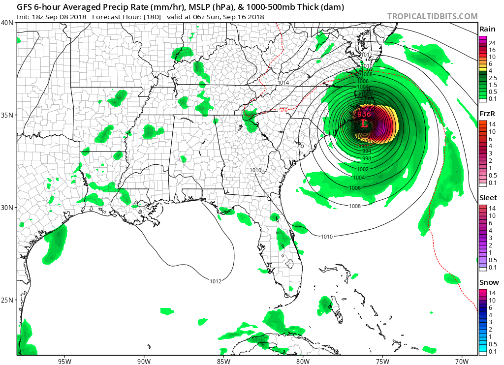
Wow looks really bad for the outer banks on this GFS run which now is going for a second landfall: 
Last edited by gatorcane on Sat Sep 08, 2018 5:27 pm, edited 1 time in total.
0 likes
-
TheDreamTraveler

- Category 2

- Posts: 645
- Joined: Sun Aug 22, 2010 3:10 am
- Location: PA
Re: ATL: FLORENCE - Models
tolakram wrote:Is stalling over the gulf stream the one place where stationary storms won't be as effected by upwelling?
Upwelling occurs anywhere in the ocean no matter the heat content. The problem is models like the GFS can't take upwelling into consideration. I was reading Ryan Maue's discussion about it on twitter earlier. Was pretty interesting.
0 likes
-
drewschmaltz
- S2K Supporter
- Posts: 351
- Joined: Thu Aug 27, 2015 8:19 pm
Re: ATL: FLORENCE - Models
Seems pretty reasonable. High five GFS.

Last edited by drewschmaltz on Sat Sep 08, 2018 5:27 pm, edited 1 time in total.
0 likes
I HAVE ABSOLUTELY NO IDEA WHAT I'M TALKING ABOUT. PLEASE CONSULT SOMEONE WHO DOES. START WITH THE NHC. ALL POSTS ARE FOR ENTERTAINMENT PURPOSES ONLY.
-
hurricaneCW
- Category 5
- Posts: 1799
- Joined: Wed Mar 03, 2010 6:20 am
- Location: Toms River, NJ
Re: ATL: FLORENCE - Models
The stall looks legit, just look at how strong the ridge is to its north and it's been trending stronger. There's nothing to send her away.
We can hope it stalls to the east of NC instead of right over it like the Euro showed.
We can hope it stalls to the east of NC instead of right over it like the Euro showed.
0 likes
-
Aric Dunn
- Category 5
- Posts: 21238
- Age: 43
- Joined: Sun Sep 19, 2004 9:58 pm
- Location: Ready for the Chase.
- Contact:
Re: ATL: FLORENCE - Models
im just really enjoying the GIANT non tropical low that drops SW none the less nearly into the sub tropics in september right next to good old florence.. .. next please..
0 likes
Note: If I make a post that is brief. Please refer back to previous posts for the analysis or reasoning. I do not re-write/qoute what my initial post said each time.
If there is nothing before... then just ask
Space & Atmospheric Physicist, Embry-Riddle Aeronautical University,
I believe the sky is falling...
If there is nothing before... then just ask
Space & Atmospheric Physicist, Embry-Riddle Aeronautical University,
I believe the sky is falling...
-
tolakram
- Admin
- Posts: 20186
- Age: 62
- Joined: Sun Aug 27, 2006 8:23 pm
- Location: Florence, KY (name is Mark)
Re: ATL: FLORENCE - Models

0 likes
M a r k
- - - - -
Join us in chat: Storm2K Chatroom Invite. Android and IOS apps also available.
The posts in this forum are NOT official forecasts and should not be used as such. Posts are NOT endorsed by any professional institution or STORM2K.org. For official information and forecasts, please refer to NHC and NWS products.
- - - - -
Join us in chat: Storm2K Chatroom Invite. Android and IOS apps also available.
The posts in this forum are NOT official forecasts and should not be used as such. Posts are NOT endorsed by any professional institution or STORM2K.org. For official information and forecasts, please refer to NHC and NWS products.
-
Blown Away

- S2K Supporter
- Posts: 10253
- Joined: Wed May 26, 2004 6:17 am
Re: ATL: FLORENCE - Models
Amazing how good the modeling is that a storm at 55W (+1500 miles away) and I feel pretty confident that a narrow area @NC is very likely the target...
0 likes
Hurricane Eye Experience: David 79, Irene 99, Frances 04, Jeanne 04, Wilma 05… Hurricane Brush Experience: Andrew 92, Erin 95, Floyd 99, Matthew 16, Irma 17, Ian 22, Nicole 22…
-
supercane4867
- Category 5
- Posts: 4966
- Joined: Wed Nov 14, 2012 10:43 am
Re: ATL: FLORENCE - Models
So the GFS first wipes Outerbanks completely off the map, then it has Flo stalling and drifting due west into Wilmington. Okay...
1 likes
-
meriland29

- Category 2
- Posts: 770
- Joined: Thu Aug 03, 2017 11:05 am
Re: ATL: FLORENCE - Models
What in the blue heck is going on with her this run? She stalled just a hair offshore and is now b lining it straight west at 186???
0 likes
-
PTrackerLA

- Category 5
- Posts: 5281
- Age: 42
- Joined: Thu Oct 10, 2002 8:40 pm
- Location: Lafayette, LA
Re: ATL: FLORENCE - Models
The major takeaway from the latest EURO and GFS runs is a collapse in steering currents seems likely. Given the potential magnitude of the freshwater flooding event folks better pray it pulls this nonsense while offshore. This is becoming quite the situation in the models!
0 likes
-
CalmBeforeStorm

- Category 2
- Posts: 600
- Age: 72
- Joined: Tue Aug 10, 2004 7:55 pm
- Location: Stuart, Florida
Re: ATL: FLORENCE - Models
Aric Dunn wrote:Steve wrote:Aric Dunn wrote:
which = poppycock.
It’s the GFS. You can’t totally discount a stall/loop as other models have shown similar. Looks to nudge sw. But what it’s showing is a strengthening ridge overtop and stronger than 12z.
you absolutely can.. because it is the GFS lol
The Euro had a similar solution only a little further west. So both major models suck?
2 likes
Who is online
Users browsing this forum: No registered users and 86 guests