
ATL: ISAAC - Models
Moderator: S2k Moderators
-
HurricaneMaster_PR

- Category 2

- Posts: 795
- Joined: Tue Jul 22, 2003 6:23 pm
- Location: San Juan, Puerto Rico

Re: ATL: ISAAC - Models
HurricaneMaster_PR wrote:Wow! 180mph with a 917mb min pressure at 120 hours.
While I do think that it could become a major hurricane, I think this goes overboard with the intensity. Are the conditions really that favorable?
1 likes
Igor 2010, Sandy 2012, Fay 2014, Gonzalo 2014, Joaquin 2015, Nicole 2016, Humberto 2019, Imelda 2025
I am only a tropical weather enthusiast. My predictions are not official and may or may not be backed by sound meteorological data. For official information, please refer to the NHC and NWS products.
I am only a tropical weather enthusiast. My predictions are not official and may or may not be backed by sound meteorological data. For official information, please refer to the NHC and NWS products.
-
supercane4867
- Category 5

- Posts: 4966
- Joined: Wed Nov 14, 2012 10:43 am
Re: ATL: ISAAC - Models
cycloneye wrote:What does HWRF see as very favorable to be that strong?
The outflow pattern in HWRF resembles last year's Jose. It has Isaac developing a very strong poleward channel enhanced by subtropical jet.
18z HWRF brings pressure down to 917mb at day 5. Windspeed may well exceed CAT5 threshold if that verifies


Last edited by supercane4867 on Sun Sep 09, 2018 7:13 pm, edited 1 time in total.
1 likes
-
Spacecoast

- Category 2
- Posts: 773
- Joined: Thu Aug 31, 2017 2:03 pm

-
jlauderdal
- S2K Supporter

- Posts: 7240
- Joined: Wed May 19, 2004 5:46 am
- Location: NE Fort Lauderdale
- Contact:
Re: RE: Re: ATL: ISAAC - Models
Keeps some people I disagree with in the gameNDG wrote:SoupBone wrote:Latest CMC doesn't turn it away before impacting the islands. It has it scraping them, then heading out to sea.
http://i64.tinypic.com/34ig28z.png
The CMC has gone from bad to really really bad as the season has gone, why even bother with it.
6 likes

Re: ATL: ISAAC - Models
cycloneye wrote:What does HWRF see as very favorable to be that strong?
That is going in between 2 high shear areas and heading to a very low shear area. Also very hot waters.
0 likes
Personal Forecast Disclaimer:
The posts in this forum are NOT official forecast and should not be used as such. They are just the opinion of the poster and may or may not be backed by sound meteorological data. They are NOT endorsed by any professional institution or storm2k.org. For official information, please refer to the NHC and NWS products.
The posts in this forum are NOT official forecast and should not be used as such. They are just the opinion of the poster and may or may not be backed by sound meteorological data. They are NOT endorsed by any professional institution or storm2k.org. For official information, please refer to the NHC and NWS products.
-
sphelps8681
- Category 2
- Posts: 785
- Joined: Thu Aug 16, 2007 5:37 pm
- Location: Somewhere over the rainbow
Re: ATL: ISAAC - Models
Blinhart wrote:SoupBone wrote:So a huge change from previous GFS runs is that the open wave (Isaac) gains latitude and heads towards the Yucatan, instead of burying itself in Honduras. If you play the model run, you can see it heading in that direction after clipping Jamaica.
So more like Harvey.
You are not suppose to say the H word!! LOL.
0 likes
-
Gustywind

- Category 5
- Posts: 12334
- Joined: Mon Sep 03, 2007 7:29 am
- Location: Baie-Mahault, GUADELOUPE
Re: ATL: ISAAC - Models
cycloneye wrote:What does HWRF see as very favorable to be that strong?
I Wonder that too, to bomb like that
0 likes

Re: ATL: ISAAC - Models
Gustywind wrote:cycloneye wrote:What does HWRF see as very favorable to be that strong?
I Wonder that too, to bomb like that, waouw
Could be it is seeing less shear in the Carribian than other models.
Shear forecasts are not known to be so accurate.
0 likes
-
AubreyStorm

- Category 1

- Posts: 337
- Age: 45
- Joined: Fri Jun 16, 2017 6:21 pm
- Location: Texas, USA
Re: ATL: ISAAC - Models
CMC

0 likes
The posts are NOT an official forecast. Please REFER to the NHC and NWS for official forecasts and products.

Re: ATL: ISAAC - Models
GFS sends it due north to central Cuba after hitting Jamaica (hour 180-192)! Run not done yet.
So that's why the NHC wrote that.
So that's why the NHC wrote that.
0 likes
Personal Forecast Disclaimer:
The posts in this forum are NOT official forecast and should not be used as such. They are just the opinion of the poster and may or may not be backed by sound meteorological data. They are NOT endorsed by any professional institution or storm2k.org. For official information, please refer to the NHC and NWS products.
The posts in this forum are NOT official forecast and should not be used as such. They are just the opinion of the poster and may or may not be backed by sound meteorological data. They are NOT endorsed by any professional institution or storm2k.org. For official information, please refer to the NHC and NWS products.
-
bamajammer4eva
- Category 4

- Posts: 907
- Joined: Sun Apr 18, 2010 3:21 am
- Location: Ozark, AL
Re: ATL: ISAAC - Models
SoupBone wrote:GFS sends it due north to central Cuba after hitting Jamaica (hour 180-192)! Run not done yet.
So that's why the NHC wrote that.
Looks to me like it goes from Jamaica to the Yucatan Channel before dissipating this run

0 likes
-
AubreyStorm
- Category 1
- Posts: 337
- Age: 45
- Joined: Fri Jun 16, 2017 6:21 pm
- Location: Texas, USA
Re: ATL: ISAAC - Models
Puerto Rico we HAVE a problem.
Ohh no Cycloneye

Ohh no Cycloneye
0 likes
The posts are NOT an official forecast. Please REFER to the NHC and NWS for official forecasts and products.
-
Tampa Bay Hurricane

- Category 5
- Posts: 5597
- Age: 38
- Joined: Fri Jul 22, 2005 7:54 pm
- Location: St. Petersburg, FL
Re: ATL: ISAAC - Models
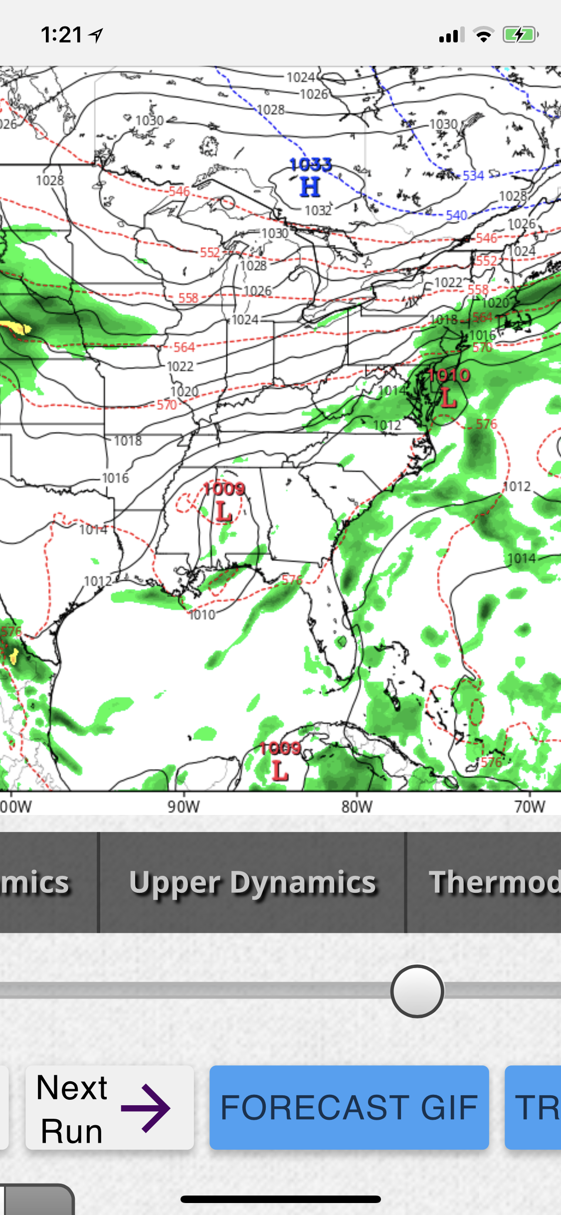
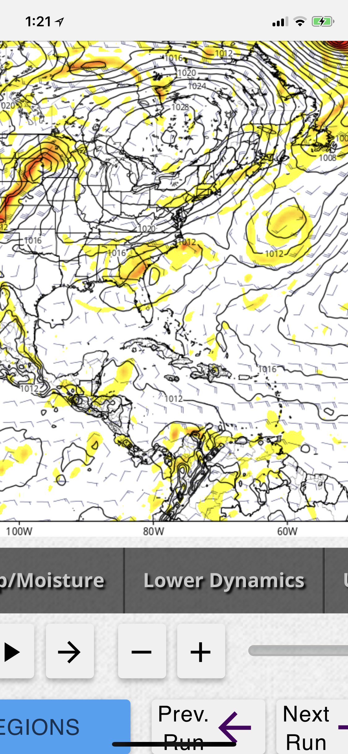
The euro and gfs in the long range (day 10) both have troughing over the GOM, this would pull whatever Isaac is into the GOM at that time if Isaac is stronger than forecasted. A weak Isaac plows into the Yucatán, but a stronger Isaac feels the influence of the trough or in the case of euro- the remnants of Florence over the gulf and gets pulled up in there. https://uploads.disquscdn.com/images/e4 ... e0266b.png https://uploads.disquscdn.com/images/cf ... 60d5a7.png
0 likes
-
bamajammer4eva
- Category 4
- Posts: 907
- Joined: Sun Apr 18, 2010 3:21 am
- Location: Ozark, AL
Re: ATL: ISAAC - Models
More gfs ensemble members hold onto Isaac through Saturday Night.Here is the trend since the 06z run

1 likes
-
MississippiWx

- S2K Supporter
- Posts: 1720
- Joined: Sat Aug 14, 2010 1:44 pm
- Location: Hattiesburg, Mississippi
Re: ATL: ISAAC - Models
bamajammer4eva wrote:More gfs ensemble members hold onto Isaac through Saturday Night.Here is the trend since the 06z run
Good catch.
3 likes
This post is not an official forecast and should not be used as such. It is just the opinion of MississippiWx and may or may not be backed by sound meteorological data. It is not endorsed by any professional institution including storm2k.org. For Official Information please refer to the NHC and NWS products.

Re: ATL: ISAAC - Models
Maybe some of the models are now factoring in the smaller eye feature?
Makes a difference but don't know if they even have a program variable for that.
Makes a difference but don't know if they even have a program variable for that.
0 likes
Re: ATL: ISAAC - Models
Maybe the UKMET, CMC, and HWRF were onto something.
0 likes
Personal Forecast Disclaimer:
The posts in this forum are NOT official forecast and should not be used as such. They are just the opinion of the poster and may or may not be backed by sound meteorological data. They are NOT endorsed by any professional institution or storm2k.org. For official information, please refer to the NHC and NWS products.
The posts in this forum are NOT official forecast and should not be used as such. They are just the opinion of the poster and may or may not be backed by sound meteorological data. They are NOT endorsed by any professional institution or storm2k.org. For official information, please refer to the NHC and NWS products.

Re: ATL: ISAAC - Models
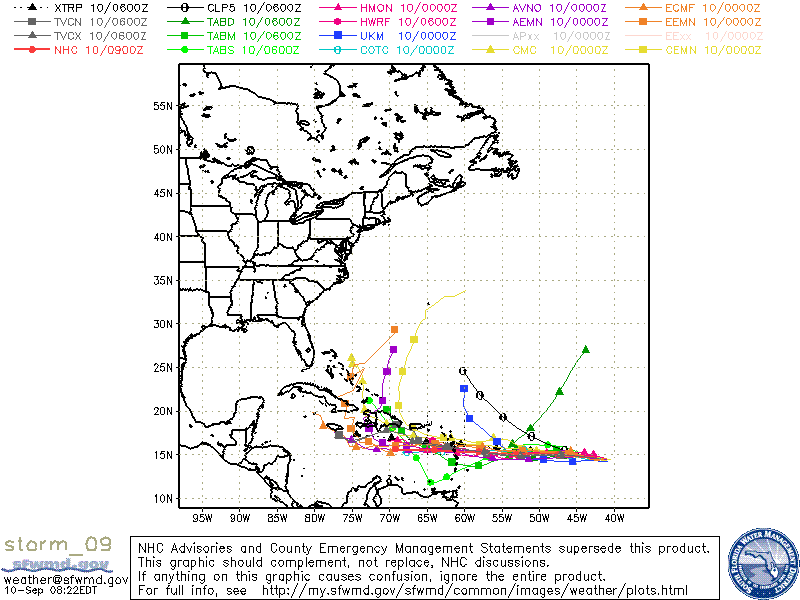
SoupBone wrote:https://s22.postimg.cc/x6tuzi05t/storm_09_1.gif
Maybe the UKMET, CMC, and HWRF were onto something.
Yeap, perhaps they are up to something with the GFS now wanting to join them.

3 likes
Re: ATL: ISAAC - Models
12z GFS sucks it poleward through the Greater Antilles.
0 likes
Igor 2010, Sandy 2012, Fay 2014, Gonzalo 2014, Joaquin 2015, Nicole 2016, Humberto 2019, Imelda 2025
I am only a tropical weather enthusiast. My predictions are not official and may or may not be backed by sound meteorological data. For official information, please refer to the NHC and NWS products.
I am only a tropical weather enthusiast. My predictions are not official and may or may not be backed by sound meteorological data. For official information, please refer to the NHC and NWS products.
Who is online
Users browsing this forum: No registered users and 462 guests