ATL: FLORENCE - Models
Moderator: S2k Moderators
-
TheDreamTraveler

- Category 2

- Posts: 645
- Joined: Sun Aug 22, 2010 3:10 am
- Location: PA
Re: ATL: FLORENCE - Models
storm4u wrote:Guess the data put into the 0z models worked!
There's not much dropsonde data in it yet. We'll know more in a few hours.
2 likes

Re: ATL: FLORENCE - Models
Models seem to be focusing on the SC-NC line area. I think the track forecast may settle in now as the system essentially rounds the ridge. The lack of any troughs and what looks like an extremely powerful storm may make the track forecast fairly straight forward from this point forward. This could be an epic storm like Hugo.
3 likes
-
gatorcane

- S2K Supporter

- Posts: 23708
- Age: 48
- Joined: Sun Mar 13, 2005 3:54 pm
- Location: Boca Raton, FL
Re: ATL: FLORENCE - Models
TheDreamTraveler wrote:storm4u wrote:Guess the data put into the 0z models worked!
There's not much dropsonde data in it yet. We'll know more in a few hours.
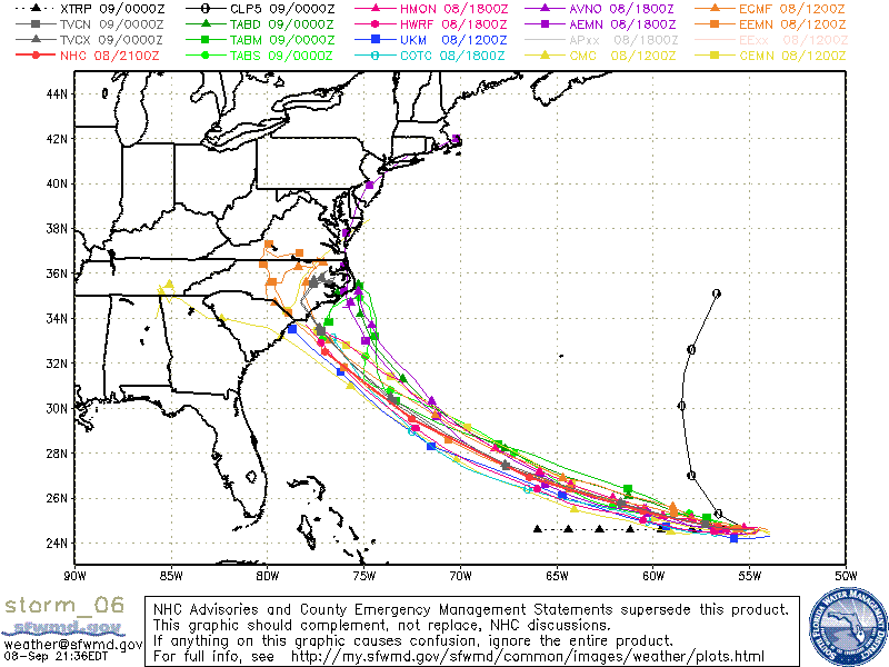
Not sure how we go from a large spread to that consensus so quickly. They had to have injected some data into these models:
1 likes
-
GeneratorPower

- S2K Supporter
- Posts: 1648
- Age: 46
- Joined: Sun Dec 18, 2005 11:48 pm
- Location: Huntsville, AL
Re: ATL: FLORENCE - Models
gatorcane wrote:TheDreamTraveler wrote:storm4u wrote:Guess the data put into the 0z models worked!
There's not much dropsonde data in it yet. We'll know more in a few hours.
Not sure how we go from a large spread to that consensus so quickly. They had to have injected some data into these models:
https://s8.postimg.cc/ghjwzc9t1/storm_06.gif
That is remarkable consensus. However, there are so many variables that at day 6, it’s hard to believe it will verify exactly.
0 likes

Re: ATL: FLORENCE - Models
NAM doesn’t have that much range into the Atlantic, and the 12km only goes out 84 hours. But that’s only 1.5/days before landfall. That should be the first model that goes out more than a day to show what the soundings show. With the offshore sampling and also the continental balloons, check it out at 500mb (10000 ft). The last run had a building ridge near Quebec toward the end of the run. That led to WNW motion. I think it was running along the 591dm height line.
We will see what it does pretty soon. Obligatory it’s the NAM.
https://www.tropicaltidbits.com/analysi ... 0812&fh=90
We will see what it does pretty soon. Obligatory it’s the NAM.
https://www.tropicaltidbits.com/analysi ... 0812&fh=90
3 likes
-
TheDreamTraveler
- Category 2
- Posts: 645
- Joined: Sun Aug 22, 2010 3:10 am
- Location: PA

-
tolakram
- Admin

- Posts: 20186
- Age: 62
- Joined: Sun Aug 27, 2006 8:23 pm
- Location: Florence, KY (name is Mark)
Re: ATL: FLORENCE - Models
gatorcane wrote:
Not sure how we go from a large spread to that consensus so quickly. They had to have injected some data into these models:
[ img]https://s8.postimg.cc/ghjwzc9t1/storm_06.gif[/img]
I'll feel better once the 0Z runs are over. The 0Z and 12Z runs of the euro about 5 days out are infamous for making a correction, at least in my memory.
1 likes
M a r k
- - - - -
Join us in chat: Storm2K Chatroom Invite. Android and IOS apps also available.
The posts in this forum are NOT official forecasts and should not be used as such. Posts are NOT endorsed by any professional institution or STORM2K.org. For official information and forecasts, please refer to NHC and NWS products.
-
toad strangler

- S2K Supporter
- Posts: 4546
- Joined: Sun Jul 28, 2013 3:09 pm
- Location: Earth
- Contact:
Re: ATL: FLORENCE - Models
gatorcane wrote:TheDreamTraveler wrote:storm4u wrote:Guess the data put into the 0z models worked!
There's not much dropsonde data in it yet. We'll know more in a few hours.
Not sure how we go from a large spread to that consensus so quickly. They had to have injected some data into these models:
Agree. That “consensus” track can shift south or east all at once. It’s way too early for that definitive language.
1 likes
My Weather Station
https://www.wunderground.com/dashboard/pws/KFLPORTS603
https://www.wunderground.com/dashboard/pws/KFLPORTS603
-
Emmett_Brown

- Category 5

- Posts: 1433
- Joined: Wed Aug 24, 2005 9:10 pm
- Location: Sarasota FL
Re: ATL: FLORENCE - Models
toad strangler wrote:gatorcane wrote:TheDreamTraveler wrote:
There's not much dropsonde data in it yet. We'll know more in a few hours.
Not sure how we go from a large spread to that consensus so quickly. They had to have injected some data into these models:
Agree. That “consensus” track can shift south or east all at once. It’s way too early for that definitive language.
Good point. Just one look at the 12z Euro ensemble shows that there is still some spread, albeit narrowing.
0 likes
Re: ATL: FLORENCE - Models
Not much difference yet with the NAMs upper air pattern at 36 hours. The ridge looks slightly stronger and the front from the Great Lakes to Texas is a hair farther back. Otherwise not much difference yet. The height lines aren’t exact between the runs but they are similar so far. 591 isn’t yet on the map at 36 hours.
https://www.tropicaltidbits.com/analysi ... 0900&fh=36
https://www.tropicaltidbits.com/analysi ... 0900&fh=36
0 likes
-
MGC

- S2K Supporter
- Posts: 5940
- Joined: Sun Mar 23, 2003 9:05 pm
- Location: Pass Christian MS, or what is left.
Re: ATL: FLORENCE - Models
Did the data from both of today's flights get into the 18Z or 0Z models? Wow that 18Z GFS run would totally destroy the outerbanks.....MGC
0 likes
-
tolakram
- Admin
- Posts: 20186
- Age: 62
- Joined: Sun Aug 27, 2006 8:23 pm
- Location: Florence, KY (name is Mark)
Re: ATL: FLORENCE - Models
MGC wrote:Did the data from both of today's flights get into the 18Z or 0Z models? Wow that 18Z GFS run would totally destroy the outerbanks.....MGC
0Z is our best guess. Not sure there is any actual confirmation.
0 likes
M a r k
- - - - -
Join us in chat: Storm2K Chatroom Invite. Android and IOS apps also available.
The posts in this forum are NOT official forecasts and should not be used as such. Posts are NOT endorsed by any professional institution or STORM2K.org. For official information and forecasts, please refer to NHC and NWS products.
- - - - -
Join us in chat: Storm2K Chatroom Invite. Android and IOS apps also available.
The posts in this forum are NOT official forecasts and should not be used as such. Posts are NOT endorsed by any professional institution or STORM2K.org. For official information and forecasts, please refer to NHC and NWS products.
-
hurricaneCW
- Category 5
- Posts: 1799
- Joined: Wed Mar 03, 2010 6:20 am
- Location: Toms River, NJ
Re: ATL: FLORENCE - Models
There's probably some room for shifts but unless there's a drastic change in the overall pattern, then I can't see more than a 50 mile change from that 5 day track.
0 likes
-
TheDreamTraveler
- Category 2
- Posts: 645
- Joined: Sun Aug 22, 2010 3:10 am
- Location: PA
Re: ATL: FLORENCE - Models
tolakram wrote:MGC wrote:Did the data from both of today's flights get into the 18Z or 0Z models? Wow that 18Z GFS run would totally destroy the outerbanks.....MGC
0Z is our best guess. Not sure there is any actual confirmation.
Levi Cowan tweeted out that the dropsonde data would be in 0z. So we should be good to go in a few hours.
2 likes
-
dukeblue219
- S2K Supporter
- Posts: 556
- Joined: Fri Sep 30, 2016 3:52 pm
Re: ATL: FLORENCE - Models
hurricaneCW wrote:There's probably some room for shifts but unless there's a drastic change in the overall pattern, then I can't see more than a 50 mile change from that 5 day track.
You know, the fact that we can even consider saying that shows how modelling has changed in the last decade-plus.
3 likes
-
SFLcane

- S2K Supporter
- Posts: 10281
- Age: 48
- Joined: Sat Jun 05, 2010 1:44 pm
- Location: Lake Worth Florida
Re: ATL: FLORENCE - Models
Hmmm consensus tonight on the Carolinas BUT I’am willing to bet in 2-3 days worth time these models will hopefully trend offshore or out to sea. Still so much time time for this to change
1 likes
-
PandaCitrus
- Category 1

- Posts: 424
- Joined: Mon Sep 04, 2017 2:44 pm
Re: ATL: FLORENCE - Models
Or possibly further north into Virginia, Delmarva peninsula, North East. A couple days ago there were a lot of solutions further north. Out to Sea isn't the only possibility here for a change.
0 likes
-
drewschmaltz
- S2K Supporter
- Posts: 351
- Joined: Thu Aug 27, 2015 8:19 pm
Re: ATL: FLORENCE - Models
hurricaneCW wrote:There's probably some room for shifts but unless there's a drastic change in the overall pattern, then I can't see more than a 50 mile change from that 5 day track.
I can see why you say that especially since the pattern is somewhat simple and the models are starting to agree. I just can't help but wonder what happens if Flo stays west just a little longer than expected. The angle she starts taking the ridge at will be so different.
I do tend to wishcast to Florida. I am guilty of that. I'll be convinced as long as Flo doesn't miss 10/0600Z 25.0N 58.3W forecast point to the south.
2 likes
I HAVE ABSOLUTELY NO IDEA WHAT I'M TALKING ABOUT. PLEASE CONSULT SOMEONE WHO DOES. START WITH THE NHC. ALL POSTS ARE FOR ENTERTAINMENT PURPOSES ONLY.
-
p1nheadlarry

- Category 2
- Posts: 672
- Age: 34
- Joined: Wed Jan 29, 2014 2:42 pm
- Location: SR County FL
Re: ATL: FLORENCE - Models
KWT wrote:Hypercane_Kyle wrote:The HWRF image being posted is at the 850mb level and would not be representative of true wind speed (but still would be a Cat 5).
Yeah but your still looking in the 145-155kts range, with gusts to 180. Which would probably make it one of the strongest ever canes in that area if it came off.
Not one of, THE strongest. 1899 holds the record at 105 kts.
0 likes
--;->#GoNoles--;->.
Who is online
Users browsing this forum: No registered users and 80 guests