Seriously????
10W MARIA 180706 0600 16.5N 141.6E WPAC 135 922
WPAC: MARIA - Post-Tropical
Moderator: S2k Moderators
-
xtyphooncyclonex

- Category 5

- Posts: 3891
- Age: 24
- Joined: Sat Dec 08, 2012 9:07 am
- Location: Cebu City
- Contact:
Re: WPAC: MARIA - Typhoon
0 likes
REMINDER: My opinions that I, or any other NON Pro-Met in this forum, are unofficial. Please do not take my opinions as an official forecast and warning. I am NOT a meteorologist. Following my forecasts blindly may lead to false alarm, danger and risk if official forecasts from agencies are ignored.
-
mrbagyo

- Category 5
- Posts: 3963
- Age: 33
- Joined: Thu Apr 12, 2012 9:18 am
- Location: 14.13N 120.98E
- Contact:
Re: WPAC: MARIA - Typhoon
Eyewall replacement cycle is well underway... Looks classic


1 likes
The posts in this forum are NOT official forecast and should not be used as such. They are just the opinion of the poster and may or may not be backed by sound meteorological data. They are NOT endorsed by any professional institution or storm2k.org. For official information, please refer to RSMC, NHC and NWS products.
-
euro6208
Re: WPAC: MARIA - Typhoon
xtyphooncyclonex wrote:Seriously????
10W MARIA 180706 0600 16.5N 141.6E WPAC 135 922
Yup we've seen this many times before. Max out at low end 5 and weaken. There's rules in the absence of recon.
0 likes
-
euro6208
Re: WPAC: MARIA - Typhoon
TPPN11 PGTW 060637
A. SUPER TYPHOON 10W (MARIA)
B. 06/0600Z
C. 16.49N
D. 141.60E
E. ONE/HMWRI8
F. T6.5/7.0/D2.5/24HRS STT: W0.5/03HRS
G. IR/EIR/VIS/MSI
H. REMARKS: 07A/PBO IRREG EYE/ANMTN. OW EYE SURROUNDED BY W
YIELDS AN E# OF 6.0. ADDED 0.5 FOR EYE ADJUSTMENT TO YIELD A DT
OF 6.5. MET IS 5.5. PT IS 6.0. DBO DT.7 NM DIAMETER EYE.
I. ADDITIONAL POSITIONS:
06/0518Z 16.50N 141.78E SSMI
ZOUFALY
0 likes
-
euro6208
Re: WPAC: MARIA - Typhoon
I don't understand how it weaken by 5 knots to a 4. Convection is stronger now and the eye remains very warm. It's all dvorak based. Truly sad. We will never know how strong it got in the absence of recon.


0 likes


-
euro6208
Re: WPAC: MARIA - Typhoon
Don't look now but the models are bringing Maria in more south than thought.


0 likes
-
mrbagyo
- Category 5
- Posts: 3963
- Age: 33
- Joined: Thu Apr 12, 2012 9:18 am
- Location: 14.13N 120.98E
- Contact:
Re: WPAC: MARIA - Typhoon
Latest microwave image shows a fairly large eye.

0 likes
The posts in this forum are NOT official forecast and should not be used as such. They are just the opinion of the poster and may or may not be backed by sound meteorological data. They are NOT endorsed by any professional institution or storm2k.org. For official information, please refer to RSMC, NHC and NWS products.

Re: WPAC: MARIA - Typhoon
I feel like we really dodged a bullet here in Guam.
Wonder what another night of development will bring us. It's just getting dark now.
Wonder what another night of development will bring us. It's just getting dark now.
0 likes

-
euro6208
Re: WPAC: MARIA - Typhoon

WDPN32 PGTW 060900
MSGID/GENADMIN/JOINT TYPHOON WRNCEN PEARL HARBOR HI//
SUBJ/PROGNOSTIC REASONING FOR SUPER TYPHOON 10W (MARIA) WARNING NR
15//
RMKS//
1. FOR METEOROLOGISTS.
2. 6 HOUR SUMMARY AND ANALYSIS.
SUPER TYPHOON (STY) 10W (MARIA), LOCATED APPROXIMATELY 254 NM
NORTHWEST OF ANDERSEN AFB, GUAM, HAS TRACKED NORTHWESTWARD AT 06
KNOTS OVER THE PAST SIX HOURS. ANIMATED MULTISPECTRAL SATELLITE
IMAGERY (MSI) SHOWS THAT STY 10W HAS MAINTAINED AN EXCELLENT CLOUD
STRUCTURE WITH A TIGHTLY DEFINED 7 NM WIDE EYE FEATURE. EXCELLENT
OUTFLOW IS ALSO EVIDENT IN MSI. THE INITIAL POSITION IS PLACED WITH
HIGH CONFIDENCE BASED ON A 060600Z HIMAWARI VISIBLE SATELLITE IMAGE
WHICH SHOWS THE WELL-DEFINED EYE. THE INITIAL INTENSITY OF 135 KNOTS
IS BASED ON A DVORAK CURRENT INTENSITY (CI) ESTIMATE OF T7.0 (140
KNOTS) FROM PGTW. A 060518Z 85GHZ SSMI MICROWAVE IMAGE SHOWS
CONCENTRIC EYEWALLS, INDICATING STY 10W IS UNDERGOING AN EYEWALL
REPLACEMENT CYCLE. EVIDENCE OF AN EYEWALL REPLACEMENT CYCLE INDICATES
STY 10W MAY EXPERIENCE A SLIGHT AND BRIEF WEAKENING AS THE OUTER
EYEWALL CONTRACTS BEFORE ANOTHER RE-INTENSIFICATION PHASE. THEREFORE,
THE INTENSITY HAS DECREASED BY 5 KNOTS SINCE THE PREVIOUS WARNING.
ENVIRONMENTAL ANALYSIS SHOWS THAT STY 10W STILL HAS EXCELLENT OUTFLOW
DUE TO TROPICAL UPPER TROPOSPHERIC TROUGH (TUTT) CELLS LOCATED TO THE
WEST AND THE NORTHEAST. STY 10W IS ALSO EXPERIENCING FAVORABLE
VERTICAL WIND SHEAR (10 TO 15 KNOTS). SEA SURFACE TEMPERATURES ALSO
REMAIN FAVORABLE (NEAR 30 DEGREES CELSIUS). STY 10W IS TRACKING
NORTHWESTWARD ALONG THE SOUTHWESTERN PERIPHERY OF THE SUBTROPICAL
RIDGE (STR) WHICH IS LOCATED TO THE NORTHEAST.
3. FORECAST REASONING.
A. THERE IS NO CHANGE TO THE FORECAST PHILOSOPHY SINCE THE
PREVIOUS PROGNOSTIC REASONING MESSAGE. DESPITE A 5 KNOT DECREASE IN
INTENSITY DUE TO AN EYEWALL REPLACEMENT CYCLE, STY 10W REMAINS IN A
FAVORABLE ENVIRONMENT AND IS EXPECTED TO RE-INTENSIFY UPON COMPLETION
OF THE EYEWALL REPLACEMENT CYCLE.
B. STY 10W IS FORECAST TO CONTINUE TRACKING NORTHWESTWARD THROUGH
TAU 36 WHILE CONTINUING TO TRACK AROUND THE AFOREMENTIONED STR. STY
10W WILL ALSO CONTINUE TO EXPERIENCE FAVORABLE OUTFLOW, VERTICAL WIND
SHEAR, AND SEA SURFACE TEMPERATURES DURING THIS TIMEFRAME. NUMERICAL
MODEL GUIDANCE IS IN GOOD AGREEMENT THROUGH TAU 72 WITH A 116NM
SPREAD AT TAU 72. THEREFORE, THERE IS HIGH CONFIDENCE IN THIS PORTION
OF THE JTWC FORECAST TRACK.
C. AFTER TAU 72, STY 10W IS FORECAST TO TRACK WEST-NORTHWESTWARD
AS THE STR TO THE NORTHEAST CONTINUES TO BUILD WESTWARD AND REMAINS
THE DOMINANT STEERING INFLUENCE. ENVIRONMENTAL CONDITIONS WILL BECOME
SLIGHTLY LESS FAVORABLE AS SEA SURFACE TEMPERATURES COOL SLIGHTLY,
OCEAN HEAT CONTENT VALUES DECREASE AND UPPER-LEVEL DIVERGENCE WEAKENS
DUE TO INCREASING NORTHERLY VERTICAL WIND SHEAR ASSOCIATED WITH A
BUILDING UPPER-LEVEL RIDGE TO THE NORTH AND NORTHWEST. NUMERICAL
MODEL GUIDANCE IS IN FAIRLY GOOD AGREEMENT WITH A 280 NM SPREAD IN
SOLUTIONS AT TAU 120. HOWEVER, THE MAJORITY OF THE MULTI-MODEL
CONSENSUS MEMBERS ARE TIGHTLY PACKED IN THE CENTER OF THE SPREAD.
THEREFORE, THERE IS HIGH CONFIDENCE IN THIS PORTION OF THE JTWC
FORECAST TRACK.//
NNNN
0 likes
Re: WPAC: MARIA - Typhoon
euro6208 wrote:I don't understand how it weaken by 5 knots to a 4. Convection is stronger now and the eye remains very warm. It's all dvorak based. Truly sad. We will never know how strong it got in the absence of recon.
Eye temp has actually cooled to OW range and microwave suggests an EWRC, all indicative of a weakening trend. It’s gonna be a short-term one though.
1 likes
Personal Forecast Disclaimer:
The posts in this forum are NOT official forecast and should not be used as such. They are just the opinion of the poster and may or may not be backed by sound meteorological data. They are NOT endorsed by any professional institution or storm2k.org. For official information, please refer to RSMC and NWS products.
The posts in this forum are NOT official forecast and should not be used as such. They are just the opinion of the poster and may or may not be backed by sound meteorological data. They are NOT endorsed by any professional institution or storm2k.org. For official information, please refer to RSMC and NWS products.
-
mrbagyo
- Category 5
- Posts: 3963
- Age: 33
- Joined: Thu Apr 12, 2012 9:18 am
- Location: 14.13N 120.98E
- Contact:
Re: WPAC: MARIA - Typhoon
Once the cycle is completed, Maria would sour to new heights.
Convection is getting colder as the sun goes down.
I think Maria has the potential to be a T7.5
Convection is getting colder as the sun goes down.
I think Maria has the potential to be a T7.5
0 likes
The posts in this forum are NOT official forecast and should not be used as such. They are just the opinion of the poster and may or may not be backed by sound meteorological data. They are NOT endorsed by any professional institution or storm2k.org. For official information, please refer to RSMC, NHC and NWS products.
-
xtyphooncyclonex
- Category 5
- Posts: 3891
- Age: 24
- Joined: Sat Dec 08, 2012 9:07 am
- Location: Cebu City
- Contact:
Re: WPAC: MARIA - Typhoon
Meanwhile, JMA says Maria has strengthened and will intensify even further.
TY 1808 (Maria)
Issued at 09:45 UTC, 6 July 2018
<Analysis at 09 UTC, 6 July>
Scale -
Intensity Violent
Center position N16°30' (16.5°)
E141°25' (141.4°)
Direction and speed of movement NW 15 km/h (7 kt)
Central pressure 920 hPa
Maximum wind speed near center 55 m/s (105 kt)
Maximum wind gust speed 75 m/s (150 kt)
≥ 50 kt wind area ALL 130 km (70 NM)
≥ 30 kt wind area ALL 330 km (180 NM)
<Forecast for 09 UTC, 7 July>
Intensity Violent
Center position of probability circle N17°50' (17.8°)
E140°55' (140.9°)
Direction and speed of movement NNW Slow
Central pressure 910 hPa
Maximum wind speed near center 55 m/s (110 kt)
Maximum wind gust speed 80 m/s (155 kt)
Radius of probability circle 90 km (50 NM)
Storm warning area ALL 240 km (130 NM)
<Forecast for 06 UTC, 8 July>
Intensity Violent
Center position of probability circle N20°10' (20.2°)
E138°55' (138.9°)
Direction and speed of movement NW 15 km/h (8 kt)
Central pressure 905 hPa
Maximum wind speed near center 55 m/s (110 kt)
Maximum wind gust speed 80 m/s (155 kt)
Radius of probability circle 180 km (95 NM)
Storm warning area ALL 350 km (190 NM)
<Forecast for 06 UTC, 9 July>
Intensity Violent
Center position of probability circle N22°30' (22.5°)
E134°05' (134.1°)
Direction and speed of movement WNW 25 km/h (13 kt)
Central pressure 905 hPa
Maximum wind speed near center 55 m/s (110 kt)
Maximum wind gust speed 80 m/s (155 kt)
Radius of probability circle 260 km (140 NM)
Storm warning area ALL 430 km (230 NM)
Digital Typhoon (based on JMA's data) says Maria has deepened by 72 mb in just 24 hours.
http://agora.ex.nii.ac.jp/digital-typho ... 08.html.en
0 likes
REMINDER: My opinions that I, or any other NON Pro-Met in this forum, are unofficial. Please do not take my opinions as an official forecast and warning. I am NOT a meteorologist. Following my forecasts blindly may lead to false alarm, danger and risk if official forecasts from agencies are ignored.
-
doomhaMwx

- Category 5
- Posts: 2487
- Age: 27
- Joined: Tue Apr 18, 2017 4:01 am
- Location: Baguio/Benguet, Philippines
- Contact:
Re: WPAC: MARIA - Typhoon
Looking quite "bumpy" just before sunset today due to ERC...
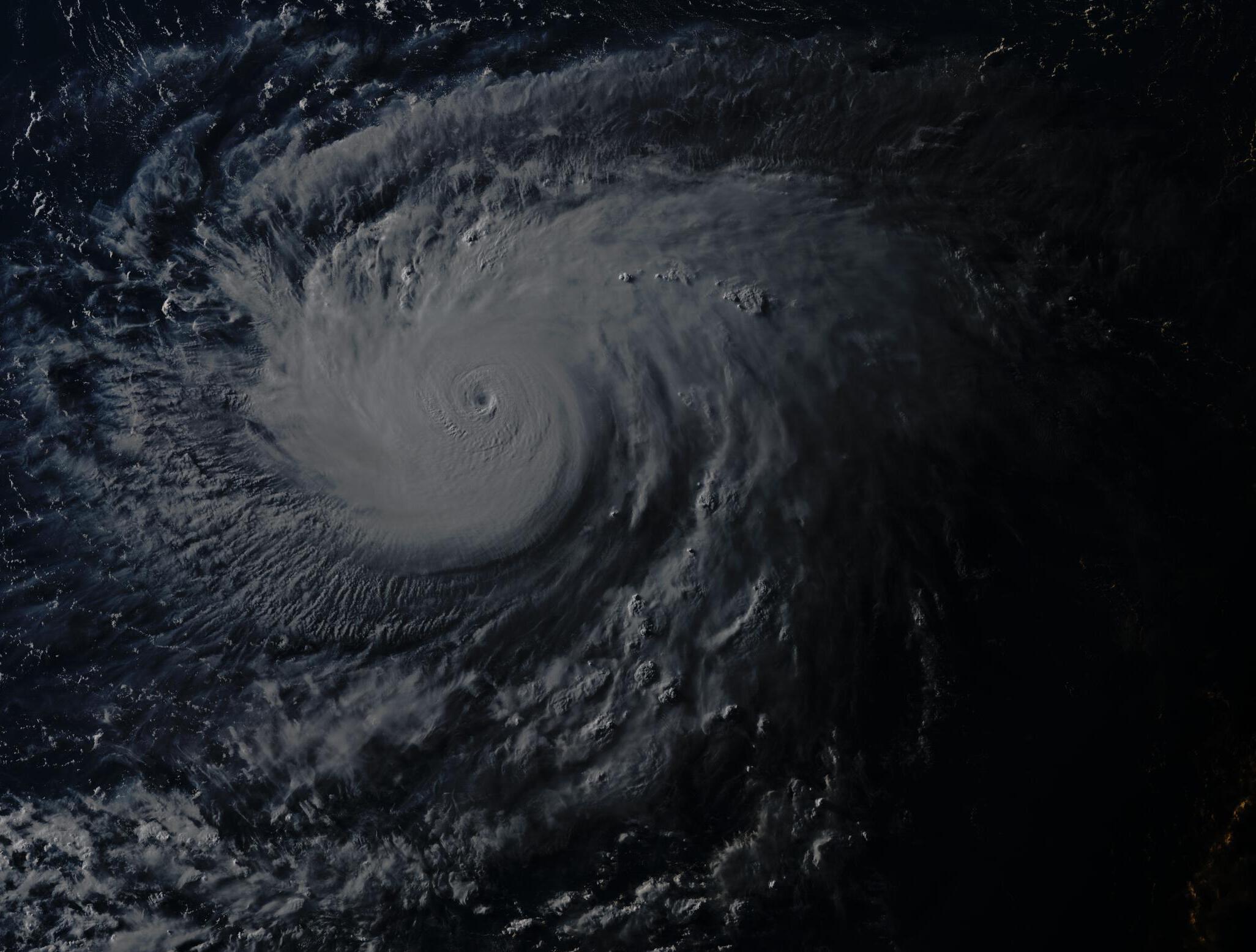
07-06-2018 08:10am UTC
07-06-2018 08:10am UTC
2 likes
-
mrbagyo
- Category 5
- Posts: 3963
- Age: 33
- Joined: Thu Apr 12, 2012 9:18 am
- Location: 14.13N 120.98E
- Contact:
Re: WPAC: MARIA - Typhoon
Latest MW.

0 likes
The posts in this forum are NOT official forecast and should not be used as such. They are just the opinion of the poster and may or may not be backed by sound meteorological data. They are NOT endorsed by any professional institution or storm2k.org. For official information, please refer to RSMC, NHC and NWS products.
-
euro6208
Re: WPAC: MARIA - Typhoon
Convection deeper/colder and eye looking smaller. Oh dear. Underestimated. Recon?

0 likes
-
xtyphooncyclonex
- Category 5
- Posts: 3891
- Age: 24
- Joined: Sat Dec 08, 2012 9:07 am
- Location: Cebu City
- Contact:
Re: WPAC: MARIA - Typhoon
euro6208 wrote:Convection deeper/colder and eye looking smaller. Oh dear. Underestimated. Recon?
It's going through an ERC. Not a time for hyperbolic estimates.
1 likes
REMINDER: My opinions that I, or any other NON Pro-Met in this forum, are unofficial. Please do not take my opinions as an official forecast and warning. I am NOT a meteorologist. Following my forecasts blindly may lead to false alarm, danger and risk if official forecasts from agencies are ignored.
Re: WPAC: MARIA - Typhoon
Signs of EWRC are now evident on EIR frames with dry moats emerging in the northern side of CDO. Although environmental conditions remain very favorable, it may take Maria another 12 hours before the EWRC is complete and re-intensification occurs.
2 likes
Personal Forecast Disclaimer:
The posts in this forum are NOT official forecast and should not be used as such. They are just the opinion of the poster and may or may not be backed by sound meteorological data. They are NOT endorsed by any professional institution or storm2k.org. For official information, please refer to RSMC and NWS products.
The posts in this forum are NOT official forecast and should not be used as such. They are just the opinion of the poster and may or may not be backed by sound meteorological data. They are NOT endorsed by any professional institution or storm2k.org. For official information, please refer to RSMC and NWS products.
-
euro6208
Re: WPAC: MARIA - Typhoon
xtyphooncyclonex wrote:euro6208 wrote:Convection deeper/colder and eye looking smaller. Oh dear. Underestimated. Recon?
It's going through an ERC. Not a time for hyperbolic estimates.
EWRC can induce weakening but not entirely. We've seen this in many Atlantic hurricanes where it develops a concentric eyewall, double-wind maximum, and an increase in the 50 to 64 knot wind radii without weakening.
2 likes
Who is online
Users browsing this forum: No registered users and 32 guests