ATL: FLORENCE - Models
Moderator: S2k Moderators
-
CyclonicFury

- Category 5

- Posts: 2032
- Age: 27
- Joined: Sun Jul 02, 2017 12:32 pm
- Location: NC
- Contact:
Re: ATL: FLORENCE - Models
LOL, 12z GFS regenerates Florence into a 974 mb hurricane by hour 186.
0 likes
NCSU B.S. in Meteorology Class of 2021. Tropical weather blogger at http://www.cyclonicfury.com. My forecasts and thoughts are NOT official, for official forecasts please consult the National Hurricane Center.
-
EquusStorm
- Category 5
- Posts: 1649
- Age: 35
- Joined: Thu Nov 07, 2013 1:04 pm
- Location: Jasper, AL
- Contact:
Re: ATL: FLORENCE - Models
Someone should probably take the Ivan playbook away from Florence before she gets any more ideas
5 likes
Colors of lost purpose on the canvas of irrelevance
Not a meteorologist, in fact more of an idiot than anything. You should probably check with the NHC or a local NWS office for official information.
Not a meteorologist, in fact more of an idiot than anything. You should probably check with the NHC or a local NWS office for official information.
-
bamajammer4eva
- Category 4

- Posts: 907
- Joined: Sun Apr 18, 2010 3:21 am
- Location: Ozark, AL

-
TxDisasterHorn

- Tropical Wave

- Posts: 8
- Age: 39
- Joined: Thu Sep 01, 2011 12:27 pm
Re: ATL: FLORENCE - Models
bamajammer4eva wrote:12z models https://uploads.tapatalk-cdn.com/20180917/fc7173542a31c252e3d7866c5fd10cf2.gif
Sent from my SM-G965U using Tapatalk
Not sure I've seen a more indecisive hurricane in my life.
1 likes
 United States Air Force Emergency Management Specialist
 -
EquusStorm
- Category 5
- Posts: 1649
- Age: 35
- Joined: Thu Nov 07, 2013 1:04 pm
- Location: Jasper, AL
- Contact:
Re: ATL: FLORENCE - Models
The most legitimately spaghetti looking of spaghetti plots
1 likes
Colors of lost purpose on the canvas of irrelevance
Not a meteorologist, in fact more of an idiot than anything. You should probably check with the NHC or a local NWS office for official information.
Not a meteorologist, in fact more of an idiot than anything. You should probably check with the NHC or a local NWS office for official information.


Re: ATL: FLORENCE - Models
Florence can't even stay in the box smh
0 likes
I am not a met. My interest and experiences come from the perspective of a hobby geologist, fisherwoman, and forager.

Re: ATL: FLORENCE - Models
Someone should probably take the Ivan playbook away from Florence before she gets any more ideas
Just a subtle reminder as to how epic the 2004-2005 season was for the CONUS
0 likes
-
Emmett_Brown

- Category 5
- Posts: 1433
- Joined: Wed Aug 24, 2005 9:10 pm
- Location: Sarasota FL
Re: ATL: FLORENCE - Models
18z GFS ensemble drops the idea of keeping Florence looping around of the east coast... all members take her up and out toward the frigid N Atlantic... the "true" hurricane graveyard...
1 likes
-
CyclonicFury
- Category 5
- Posts: 2032
- Age: 27
- Joined: Sun Jul 02, 2017 12:32 pm
- Location: NC
- Contact:
Re: ATL: FLORENCE - Models
I don't think this is directly associated with Florence (though it does seem to come from the same frontal boundary), but all of the global models are suggesting that a new warm core (perhaps subtropical) low may develop along this boundary in about five days over the central Atlantic in the "2018 MDR" - around the same place Debby, Ernesto and Joyce formed. I'm not sure how NHC would handle this if it developed (it might be Kirk), but if they were to assign it the name Florence, we could be looking at one of the strangest and longest lived tracks in history.
0 likes
NCSU B.S. in Meteorology Class of 2021. Tropical weather blogger at http://www.cyclonicfury.com. My forecasts and thoughts are NOT official, for official forecasts please consult the National Hurricane Center.
-
EquusStorm
- Category 5
- Posts: 1649
- Age: 35
- Joined: Thu Nov 07, 2013 1:04 pm
- Location: Jasper, AL
- Contact:
Re: ATL: FLORENCE - Models
Honestly I think it'd take a long look at long spanning loops to determine how much of the vorticity stayed intact and even then it'd be a subjective call; an Ivan vs TD10/12 sort of thing. Clearly some of the energy involved will involve Florence's remnants in some way, but if absorbed into a linear boundary and a new area develops along it later, one could make the case for Kirk. Ivan's low level remnants as weak as they were could be easily tracked, at least.
0 likes
Colors of lost purpose on the canvas of irrelevance
Not a meteorologist, in fact more of an idiot than anything. You should probably check with the NHC or a local NWS office for official information.
Not a meteorologist, in fact more of an idiot than anything. You should probably check with the NHC or a local NWS office for official information.
-
TheStormExpert
Re: ATL: FLORENCE - Models
18z GFS regenerates Florence into a 971mb storm in the North-Central Atlantic.
0 likes
-
gatorcane

- S2K Supporter

- Posts: 23708
- Age: 48
- Joined: Sun Mar 13, 2005 3:54 pm
- Location: Boca Raton, FL
Re: ATL: FLORENCE - Models
TheStormExpert wrote:18z GFS regenerates Florence into a 971mb storm in the North-Central Atlantic.
Heading W or WNW:
0 likes
-
Emmett_Brown
- Category 5
- Posts: 1433
- Joined: Wed Aug 24, 2005 9:10 pm
- Location: Sarasota FL
Re: ATL: FLORENCE - Models
If this ends up developing, and keeps the name Florence, this would indeed be a long lived ace machine. Florence formed in early September, so it would rank up there with the long lived storms in history. Or, it might just end up being named Kirk, and not be that special.
Last edited by Emmett_Brown on Tue Sep 18, 2018 9:08 pm, edited 1 time in total.
1 likes


Re: ATL: FLORENCE - Models
TheStormExpert wrote:18z GFS regenerates Florence into a 971mb storm in the North-Central Atlantic.
Is that the same system? Looks like Flo is NE of the system that develops.

0 likes
Re: ATL: FLORENCE - Models
The 0z CMC Redevelops Florence, and sends it right back for a second landfall in Wilmington, where it stalls yet again.

0 likes
Re: ATL: FLORENCE - Models
I just checked the UKMET panels, and it too redevelops a break away piece of Florence into a very weak tropical system, and then sends that system back to the Carolina coastline echoing the CMC.
The 0z GFS, sends some moisture back to the Carolina's, but not an organized system.
The 0z GFS, sends some moisture back to the Carolina's, but not an organized system.
0 likes
-
Hurricaneman

- Category 5
- Posts: 7404
- Age: 45
- Joined: Tue Aug 31, 2004 3:24 pm
- Location: central florida
Re: ATL: FLORENCE - Models
It looks like Florence has a baby on the GFS and sends it to North Carolina, while Florence itself gets trapped in the Central Atlantic and retrogrades and threatens Bermuda and here’s the thing that small low that detaches from it would probably get the name Kirk if it develops or if the MDR disturbance develops first that little system if it develops could be Leslie
0 likes
-
Hurricaneman
- Category 5
- Posts: 7404
- Age: 45
- Joined: Tue Aug 31, 2004 3:24 pm
- Location: central florida
Re: ATL: FLORENCE - Models
MrStormX wrote:The 0z CMC Redevelops Florence, and sends it right back for a second landfall in Wilmington, where it stalls yet again.
https://www.tropicaltidbits.com/analysis/models/gem/2018091900/gem_mslp_pcpn_atl_29.png
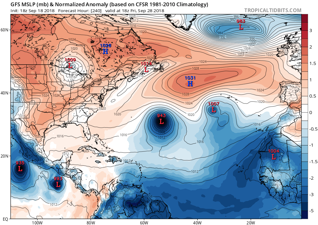
That’s not Florence, that’s Florence’s baby, Florence is the system at 50W 28N on that map
0 likes
Re: ATL: FLORENCE - Models
Hurricaneman wrote:MrStormX wrote:The 0z CMC Redevelops Florence, and sends it right back for a second landfall in Wilmington, where it stalls yet again.
https://www.tropicaltidbits.com/analysis/models/gem/2018091900/gem_mslp_pcpn_atl_29.png
That’s not Florence, that’s Florence’s baby, Florence is the system at 50W 28N on that map
stormcentral, post: 111337, member: 329 wrote:Models stall florence remnants near Bermuda or southward for a week
A portion of the remnants of Flo (Flo’s baby?) continue to show up on all models moving SE toward Bermuda today before making a clockwise turn back to westerly this weekend as it becomes positioned below a 200 mb high that moves offshore in the W Atlantic tomorrow and sticks around near Bermuda into early next week. This disturbance then approaches the SE US coast Mon before either recurving just offshore or coming into the coast by Tue. This general scenario has been showing up on model consensus for many days now only as a weak system. Still, no model at this time brings it in as more than a trough that ups shower activity. So, conditions aren’t expected to be favorable tropically. However, shear doesn’t appear to be strong as there are no westerlies nearby due to this strong 200 mb Bermuda high to the north of Flo’s baby keeping the westerlies away for the next 4-5 days and instead providing very high level easterlies. Also, SSTs off the SE coast are still very warm (midsummer warmth of 29-30C). So, this will probably get some attention at the BBs over the weekend whether or not warranted.
0 likes
Personal Forecast Disclaimer:
The posts in this forum are NOT official forecasts and should not be used as such. They are just the opinion of the poster and may or may not be backed by sound meteorological data. They are NOT endorsed by any professional institution or storm2k.org. For official information, please refer to the NHC and NWS products.
The posts in this forum are NOT official forecasts and should not be used as such. They are just the opinion of the poster and may or may not be backed by sound meteorological data. They are NOT endorsed by any professional institution or storm2k.org. For official information, please refer to the NHC and NWS products.
Who is online
Users browsing this forum: No registered users and 77 guests