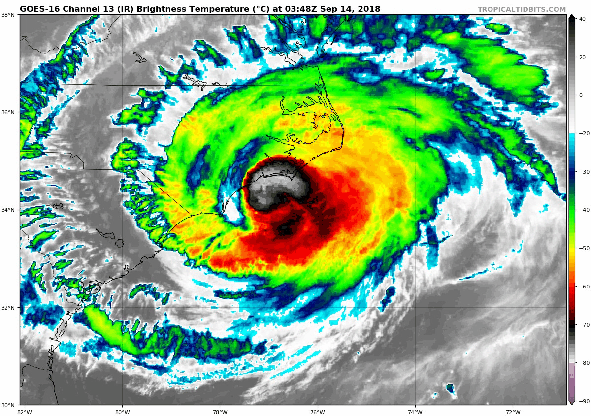
MississippiWx wrote:hurricaneCW wrote:Outer eyewall looks like it's taking over now, really tightening up on radar.
This is why I believe it could be deepening some.
Albeit not using recon the nhc has her holding steady at 2am.
Moderator: S2k Moderators


MississippiWx wrote:hurricaneCW wrote:Outer eyewall looks like it's taking over now, really tightening up on radar.
This is why I believe it could be deepening some.


TheDreamTraveler wrote:SouthFloridawx wrote:Regardless, this is a hurricane that appears to be stationary on our coast. I think that it's pretty crazy if you ask me.PavelGaborik10 wrote:It's out of time. Will still be a bad storm but far from the cat 4 monster we expected a couple days ago.northjaxpro wrote:I hope I am wrong but as I stated a couple of pages back, but it is my fear that Recon will find an intensifying hurricane.
That's the best thing about it stalling out on the coast. As it keeps upwelling water it'll continue to weaken. It's still a huge problem that it's barely moving but at least it won't get any stronger.

eastcoastFL wrote:Mandatory Data...
Observation Time: 5:31Z on Friday
Coordinates: 32.9N 78.5W
Location: 87 statute miles (140 km) to the E (85°) from Charleston, SC, USA.
Pressure Altitude: 3,050 meters (10,007 feet)
Flight Level Wind: From 310° at 36 knots (From the NW at ~ 41.4 mph)
- The above is a spot wind.
- Winds were obtained using doppler radar or inertial systems.
Flight Level Air Temperature: 10°C (50°F)
Flight Level Dew Point: 8°C (46°F)
Weather (within 30 nm): Shower(s) (continuous or intermittent precipitation - from cumuliform clouds)
Turbulence: None
Conditions Along Flight Route: In and out of clouds
Radar Capability: Yes
700 mb Surface Altitude: 3,094 geopotential meters (10,151 geopotential feet)
Remarks Section ...
Surface Wind Speed (likely by SFMR): 40 knots (~ 46.0 mph)
Start of inbound leg to the center in the southwest quadrant.

meriland29 wrote:eastcoastFL wrote:Mandatory Data...
Observation Time: 5:31Z on Friday
Coordinates: 32.9N 78.5W
Location: 87 statute miles (140 km) to the E (85°) from Charleston, SC, USA.
Pressure Altitude: 3,050 meters (10,007 feet)
Flight Level Wind: From 310° at 36 knots (From the NW at ~ 41.4 mph)
- The above is a spot wind.
- Winds were obtained using doppler radar or inertial systems.
Flight Level Air Temperature: 10°C (50°F)
Flight Level Dew Point: 8°C (46°F)
Weather (within 30 nm): Shower(s) (continuous or intermittent precipitation - from cumuliform clouds)
Turbulence: None
Conditions Along Flight Route: In and out of clouds
Radar Capability: Yes
700 mb Surface Altitude: 3,094 geopotential meters (10,151 geopotential feet)
Remarks Section ...
Surface Wind Speed (likely by SFMR): 40 knots (~ 46.0 mph)
Start of inbound leg to the center in the southwest quadrant.
So she is a TS now?

SouthFloridawx wrote:Regardless, this is a hurricane that appears to be stationary on our coast. I think that it's pretty crazy if you ask me.PavelGaborik10 wrote:It's out of time. Will still be a bad storm but far from the cat 4 monster we expected a couple days ago.
meriland29 wrote:Okay, thanks guys...I sped through that read a little.


meriland29 wrote:She sure looks to be heading S if anything...
https://www.tropicaltidbits.com/sat/satlooper.php?region=06L&product=ir-dvorak
Users browsing this forum: No registered users and 159 guests


