If you're having trouble with the NOAA page try this (click on the "I" first):
http://tropic.ssec.wisc.edu/#
ATL: ALBERTO - Post-Tropical
Moderator: S2k Moderators
Re: ATL: INVEST 90L - Discussion
1 likes
-
CrazyC83
- Professional-Met

- Posts: 34315
- Joined: Tue Mar 07, 2006 11:57 pm
- Location: Deep South, for the first time!
Re: ATL: INVEST 90L - Discussion
LarryWx wrote:CrazyC83 wrote:LarryWx wrote:I've seen enough. In agreement with the NHC and also based on satellite/model trends, I'm now expecting a TS to form in the GOM along with a TS threat to the US GOM coast early next week from the FL Panhandle westward. I now think there's even a 5% chance for a H hit. If a TS+ landfalls in AL or westward by 5/29, it would become the earliest TS to hit in that part of the US on record back to 1851!
I think reanalysis found an earlier storm to hit in 1957 (more than a month before Audrey in the same area)?
I'm not aware of this but that's interesting if true. I did find an earlier one than Audrey here though with a June 8th genesis:
http://weather.unisys.com/hurricane/atl ... /track.gif
Is this by any chance that one?
That might be what I was thinking of.
0 likes

Re: ATL: INVEST 90L - Discussion
Frank2 wrote:In the 240 nm range of the Key West radar, the western-most echos (closest to the disturbance) have a northward movement of ~ 10 mph...
https://radar.weather.gov/radar.php?pro ... X&loop=yes
I can still see the remnants of the old low level circulation further south closer to Belize without much convection. Appears to be a new circulation getting started just off the northern coast line of the Yucatan maybe 50 miles west of the channel. Easy to get lost looking at extremely local observations, winds in and around thunderstorms create all kinds of almost random inflow patterns.
1 likes
-
Aric Dunn
- Category 5

- Posts: 21238
- Age: 43
- Joined: Sun Sep 19, 2004 9:58 pm
- Location: Ready for the Chase.
- Contact:
Re: ATL: INVEST 90L - Models
Nam is about 100 miles west at 54 hours... could be an even earlier turn west..
0 likes
Note: If I make a post that is brief. Please refer back to previous posts for the analysis or reasoning. I do not re-write/qoute what my initial post said each time.
If there is nothing before... then just ask
Space & Atmospheric Physicist, Embry-Riddle Aeronautical University,
I believe the sky is falling...
If there is nothing before... then just ask
Space & Atmospheric Physicist, Embry-Riddle Aeronautical University,
I believe the sky is falling...
-
Aric Dunn
- Category 5
- Posts: 21238
- Age: 43
- Joined: Sun Sep 19, 2004 9:58 pm
- Location: Ready for the Chase.
- Contact:
Re: ATL: INVEST 90L - Models
18z NAM is significantly slower.. the trough over the mountain west is not as far east.. ridging is stronger initially..
0 likes
Note: If I make a post that is brief. Please refer back to previous posts for the analysis or reasoning. I do not re-write/qoute what my initial post said each time.
If there is nothing before... then just ask
Space & Atmospheric Physicist, Embry-Riddle Aeronautical University,
I believe the sky is falling...
If there is nothing before... then just ask
Space & Atmospheric Physicist, Embry-Riddle Aeronautical University,
I believe the sky is falling...
-
DestinHurricane

- Category 4

- Posts: 935
- Joined: Tue May 01, 2018 8:05 am
- Location: New York, NY
Re: ATL: INVEST 90L - Discussion
Any chance we will get a TD by tomorrow night?
0 likes
Michael 2018
-
Aric Dunn
- Category 5
- Posts: 21238
- Age: 43
- Joined: Sun Sep 19, 2004 9:58 pm
- Location: Ready for the Chase.
- Contact:
Re: ATL: INVEST 90L - Models
Ridging just pumped up from 72 to 84 hours. quite a bit more the 12z. 90l barely even makes into the north central gulf before turning wsw to sw ! if the ridging is this strong witht he test of the guidance for 18z and 00z.. watch out texas ..
0 likes
Note: If I make a post that is brief. Please refer back to previous posts for the analysis or reasoning. I do not re-write/qoute what my initial post said each time.
If there is nothing before... then just ask
Space & Atmospheric Physicist, Embry-Riddle Aeronautical University,
I believe the sky is falling...
If there is nothing before... then just ask
Space & Atmospheric Physicist, Embry-Riddle Aeronautical University,
I believe the sky is falling...
-
stormlover2013
-
Aric Dunn
- Category 5
- Posts: 21238
- Age: 43
- Joined: Sun Sep 19, 2004 9:58 pm
- Location: Ready for the Chase.
- Contact:
Re: ATL: INVEST 90L - Models
stormlover2013 wrote:But Aric really?? U really think ridging will be that strong ?
no reason it cant be.. if the west coast trough does not progress east fast enough then yes strong ridging will build in quickly and the trough will likely go up and over the ridge. which is what looks like would happen if NAM went passed 84 hours.
90L moving do west south of LA at the end of run
0 likes
Note: If I make a post that is brief. Please refer back to previous posts for the analysis or reasoning. I do not re-write/qoute what my initial post said each time.
If there is nothing before... then just ask
Space & Atmospheric Physicist, Embry-Riddle Aeronautical University,
I believe the sky is falling...
If there is nothing before... then just ask
Space & Atmospheric Physicist, Embry-Riddle Aeronautical University,
I believe the sky is falling...
-
Aric Dunn
- Category 5
- Posts: 21238
- Age: 43
- Joined: Sun Sep 19, 2004 9:58 pm
- Location: Ready for the Chase.
- Contact:
Re: ATL: INVEST 90L - Models
18Z ICON is running too. lets see if it makes it to Texas this time again.
0 likes
Note: If I make a post that is brief. Please refer back to previous posts for the analysis or reasoning. I do not re-write/qoute what my initial post said each time.
If there is nothing before... then just ask
Space & Atmospheric Physicist, Embry-Riddle Aeronautical University,
I believe the sky is falling...
If there is nothing before... then just ask
Space & Atmospheric Physicist, Embry-Riddle Aeronautical University,
I believe the sky is falling...
Re: ATL: INVEST 90L - Discussion
DestinHurricane wrote:Any chance we will get a TD by tomorrow night?
Usually these close to home systems get upgraded by recon, but a TD only needs a clear closed circulation. Sheared systems usually take longer to verify.
1 likes
-
Aric Dunn
- Category 5
- Posts: 21238
- Age: 43
- Joined: Sun Sep 19, 2004 9:58 pm
- Location: Ready for the Chase.
- Contact:
Re: ATL: INVEST 90L - Models
Models must have got some new data. the trough over the eastern Pacific is much more amplified and the ridging on the ICON over the mountain west intern is also stronger. this will be interesting.
0 likes
Note: If I make a post that is brief. Please refer back to previous posts for the analysis or reasoning. I do not re-write/qoute what my initial post said each time.
If there is nothing before... then just ask
Space & Atmospheric Physicist, Embry-Riddle Aeronautical University,
I believe the sky is falling...
If there is nothing before... then just ask
Space & Atmospheric Physicist, Embry-Riddle Aeronautical University,
I believe the sky is falling...
-
TreasureIslandFLGal

- S2K Supporter

- Posts: 1584
- Age: 58
- Joined: Sun Aug 15, 2004 6:16 pm
- Location: Cancun, Mexico (northeast Yucatan coast)
Re: ATL: INVEST 90L - Models
would love to see this go way west and maybe give us a chance to dry out a little here in Florida! It would be great to have a decent holiday weekend after all.
1 likes
Chrissy & Ligeia

-
lrak

- S2K Supporter
- Posts: 1770
- Age: 59
- Joined: Thu Jun 21, 2007 2:48 pm
- Location: Corpus Christi, TX
Re: ATL: INVEST 90L - Models
Possibly Memorial Day surf Aric?
1 likes
AKA karl
Also
Personal Forecast Disclaimer:
My posts on this forum are NOT official forecast and should not be used as such. My posts are my basic observations and are definitely not backed by any "well some" meteorological knowledge. For official information, please refer to the NHC and NWS products.
Also
Personal Forecast Disclaimer:
My posts on this forum are NOT official forecast and should not be used as such. My posts are my basic observations and are definitely not backed by any "well some" meteorological knowledge. For official information, please refer to the NHC and NWS products.
-
gatorcane

- S2K Supporter
- Posts: 23708
- Age: 48
- Joined: Sun Mar 13, 2005 3:54 pm
- Location: Boca Raton, FL
Re: ATL: INVEST 90L - Discussion
Sure looks like a bit of an ESE tug going on but overall movement is erratic and looks stationary as shear hits it:
http://rammb.cira.colostate.edu/ramsdis ... display=12
Shear tendency map does show shear is decreasing north of the Yucatan:
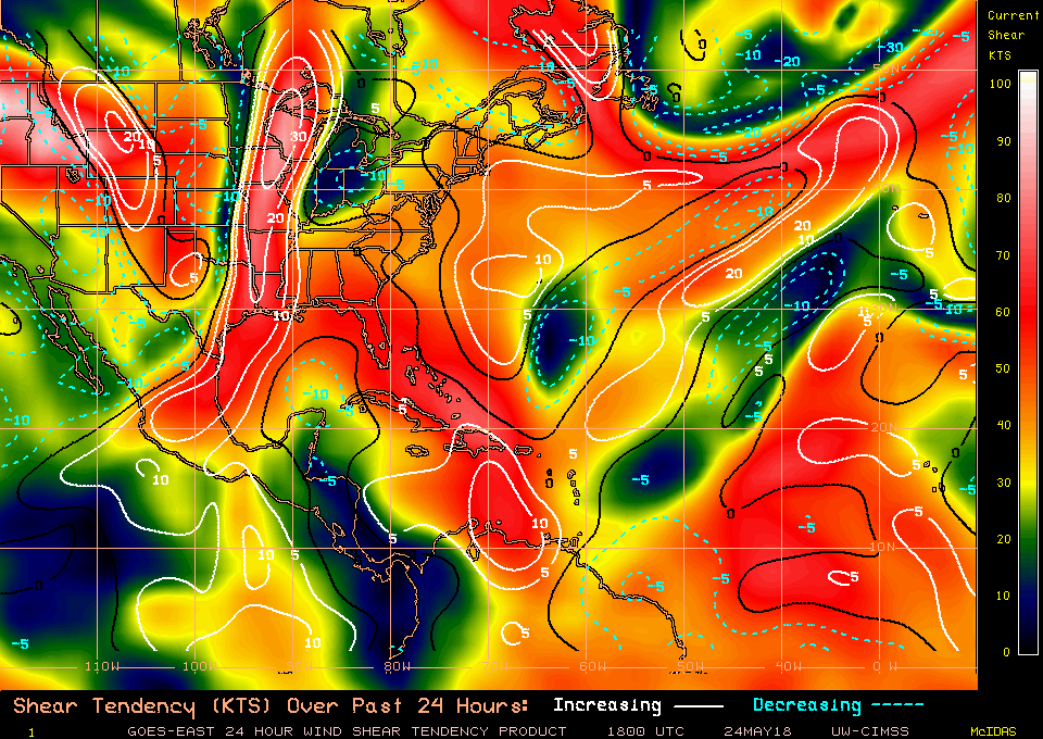
http://rammb.cira.colostate.edu/ramsdis ... display=12
Shear tendency map does show shear is decreasing north of the Yucatan:
0 likes
-
Aric Dunn
- Category 5
- Posts: 21238
- Age: 43
- Joined: Sun Sep 19, 2004 9:58 pm
- Location: Ready for the Chase.
- Contact:
Re: ATL: INVEST 90L - Models
lrak wrote:Possibly Memorial Day surf Aric?
Should be
0 likes
Note: If I make a post that is brief. Please refer back to previous posts for the analysis or reasoning. I do not re-write/qoute what my initial post said each time.
If there is nothing before... then just ask
Space & Atmospheric Physicist, Embry-Riddle Aeronautical University,
I believe the sky is falling...
If there is nothing before... then just ask
Space & Atmospheric Physicist, Embry-Riddle Aeronautical University,
I believe the sky is falling...
-
lrak
- S2K Supporter
- Posts: 1770
- Age: 59
- Joined: Thu Jun 21, 2007 2:48 pm
- Location: Corpus Christi, TX
Re: ATL: INVEST 90L - Models
Aric Dunn wrote:lrak wrote:Possibly Memorial Day surf Aric?
Should be
YAY thanks for the quick response. Time to call all the old bros!
1 likes
AKA karl
Also
Personal Forecast Disclaimer:
My posts on this forum are NOT official forecast and should not be used as such. My posts are my basic observations and are definitely not backed by any "well some" meteorological knowledge. For official information, please refer to the NHC and NWS products.
Also
Personal Forecast Disclaimer:
My posts on this forum are NOT official forecast and should not be used as such. My posts are my basic observations and are definitely not backed by any "well some" meteorological knowledge. For official information, please refer to the NHC and NWS products.
-
Aric Dunn
- Category 5
- Posts: 21238
- Age: 43
- Joined: Sun Sep 19, 2004 9:58 pm
- Location: Ready for the Chase.
- Contact:
Re: ATL: INVEST 90L - Models
lol of course.. so far. ICON way east of 12z.. does a much wide turn for some reason. maybe shear..
84 hours it is stalled south of Mississippi, though ridging is building strong so should not go north.. same timing as NAM just a larger turn.
84 hours it is stalled south of Mississippi, though ridging is building strong so should not go north.. same timing as NAM just a larger turn.
Last edited by Aric Dunn on Thu May 24, 2018 4:14 pm, edited 1 time in total.
0 likes
Note: If I make a post that is brief. Please refer back to previous posts for the analysis or reasoning. I do not re-write/qoute what my initial post said each time.
If there is nothing before... then just ask
Space & Atmospheric Physicist, Embry-Riddle Aeronautical University,
I believe the sky is falling...
If there is nothing before... then just ask
Space & Atmospheric Physicist, Embry-Riddle Aeronautical University,
I believe the sky is falling...
-
AdamFirst

- S2K Supporter
- Posts: 2490
- Age: 36
- Joined: Thu Aug 14, 2008 10:54 am
- Location: Port Saint Lucie, FL
Re: ATL: INVEST 90L - Models
18z ICON has trended east. Same pattern as the 12z run - but the storm has a closer approach to Florida and meanders south of Pensacola instead of the Mississippi River Delta.
1 likes
Dolphins Marlins Canes Golden Panthers HEAT
Andrew 1992 - Irene 1999 - Frances 2004 - Jeanne 2004 - Wilma 2005 - Fay 2008 - Isaac 2012 - Matthew 2016 - Irma 2017 - Dorian 2019 - Ian 2022 - Nicole 2022 - Milton 2024
Andrew 1992 - Irene 1999 - Frances 2004 - Jeanne 2004 - Wilma 2005 - Fay 2008 - Isaac 2012 - Matthew 2016 - Irma 2017 - Dorian 2019 - Ian 2022 - Nicole 2022 - Milton 2024
Who is online
Users browsing this forum: No registered users and 17 guests