LarryWx wrote:txwatcher91 wrote:toad strangler wrote:
We are talking about MAY climo. Not SEPTEMBER clomp. Gigantic difference.
It doesn’t matter, September climo doesn’t favor multiple cat 5s but it happened. Point is the models are tools and to be used as such. The Euro and NAM showing a storm that deepens quickly up until landfall, possibly sub 980mb, is worth considering as a possibility. The shear charts show an anticyclone developing providing nice outflow and reducing shear dramatically. The loop current is plenty warm at 27-29C as well. May climo says there should be 50kts of shear to rip this apart but if modeling is correct it will be very low and favor steady intensification...
From my perspective, climo doesn't say what will definitely happen or not happen. Instead, it is a tool that suggests probabilities. So, in those cases where climo didn't/did favor something and it still happened/didn't happen, I don't look at that as saying climo was "wrong" per se. Rather, I'd think of climo as not helping in those cases. Regardless, climo will, of course, be helpful in most cases if used correctly.
Sometimes climo based suggestions are stronger than others. That there won't be a 0Z 3K NAM type major H (955 mb) in late May in the Gulf is an EXTREMELY strong suggestion by climo because there has not been one on record back to 1851. Heck, there has been only one H of any strength in the Gulf on record since 1851 and even that was over 150 years ago! That there won't be a major H is something I'd bet heavily on and feel very comfortable about my chances.
Larry, I agree completely that climo is a good tool to use for probabilities, similar to how models are to be used as tools but not verbatim outputs. My contention is with the suggestion that this will follow May climo and won't be anything more than a sheared TS. When looking at several of the best tools we have like the Euro and HWRF they have consistently pointed to a 980-985mb system, likely a cat 1 hurricane. While the 3km NAM is certainly overdone with its recent run of 947mb, I think the key to note is it picks up on an environment that is favorable of steady to rapid intensification. It did something similar with Harvey, showing it getting down to 915-920mb and a lot of people thought that was nuts only to see Harvey bomb out into a strong cat 4 by landfall. A lot certainly will depend on the track, how fast the LLC gets going, the trough placement, etc. but I like the chances for a cat 1 hurricane at landfall based on the model data we have. It certainly will be interesting to watch all of this unfold and I hope folks in the path of this are prepared for a lot of rain and the possibility for a hurricane. A rapidly intensifying storm up to landfall with beaches full of vacationers is not a good scenario.. better to be prepared than caught off guard is how I see it.
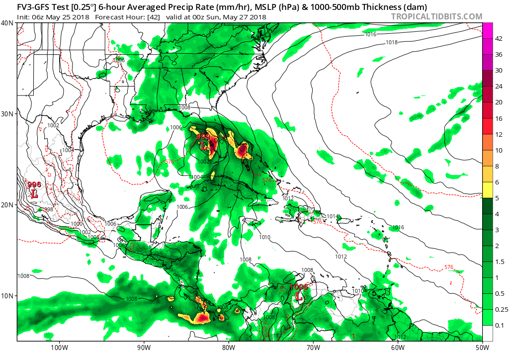
Not much has been said of the FV3 GFS but it now seems to be picking up a bit more on development as well. Here is the latest run indicating a 987mb system a bit further east than other models. So far I have not been impressed with the FV3 GFS in how it has handled things, it seems to really be struggling with feedback issues more than the regular GFS.


, but do sheared TSs usually have that squall line "tail"?