

ATL: FLORENCE - Post-Tropical - Discussion
Moderator: S2k Moderators
Re: ATL: FLORENCE - Tropical Storm - Discussion
The counties near the outer banks are very close to the path around the Bermuda high, but I see that New Hanover,Brunswick and Pender counties have all recieved 4 majors since 1900. Don't remember when the last time storm surge flooded New Bern like this?
0 likes
-
WilmingtonSandbar
- S2K Supporter

- Posts: 503
- Joined: Sun Aug 29, 2010 12:11 pm
- Location: Southport, NC
Re: ATL: FLORENCE - Tropical Storm - Discussion
Not sure if this is the right location to post this, but I just got internet back, for a short time. Going to upload before and after pics of The Big Lake in Boiling Spring Lakes NC. The city, through a system of damns, lowered the the lake about 8 feet before the storm. The after pics were taken about 2 hours ago, and the rain is still coming in hard. I have been here for every storm since Diana, and this is the worse flooding have ever seen.


3 likes
Diana X2 (look it up), Bertha, Fran, Bonnie, Floyd, Dennis, Charley, Ophelia, Ernesto, Irene, Matthew, And Florence
-
WilmingtonSandbar
- S2K Supporter
- Posts: 503
- Joined: Sun Aug 29, 2010 12:11 pm
- Location: Southport, NC
Re: ATL: FLORENCE - Tropical Storm - Discussion
Just one more pic. Notice that the bridge is now gone. This pic was taken at 2:10pm Saturday, September 14.

8 likes
Diana X2 (look it up), Bertha, Fran, Bonnie, Floyd, Dennis, Charley, Ophelia, Ernesto, Irene, Matthew, And Florence
-
galaxy401

- Category 5

- Posts: 2299
- Age: 28
- Joined: Sat Aug 25, 2012 9:04 pm
- Location: Casa Grande, Arizona
Re: ATL: FLORENCE - Tropical Storm - Discussion
Be careful out there WilmingtonSandbar. Looks like Southport is under constant heavy rain right now thanks to those feeder bands. Could continue for a while.
2 likes
Got my eyes on moving right into Hurricane Alley: Florida.
-
northjaxpro

- S2K Supporter
- Posts: 8900
- Joined: Mon Sep 27, 2010 11:21 am
- Location: Jacksonville, FL
Re: ATL: FLORENCE - Tropical Storm - Discussion
I think my eyes are likely weary, but is the center of circulation drifting to the south currently?
0 likes
NEVER, EVER SAY NEVER in the tropics and weather in general, and most importantly, with life itself!!
________________________________________________________________________________________
Fay 2008 Beryl 2012 Debby 2012 Colin 2016 Hermine 2016 Julia 2016 Matthew 2016 Irma 2017 Dorian 2019
________________________________________________________________________________________
Fay 2008 Beryl 2012 Debby 2012 Colin 2016 Hermine 2016 Julia 2016 Matthew 2016 Irma 2017 Dorian 2019
-
wayoutfront
- Tropical Low

- Posts: 23
- Joined: Mon Sep 04, 2017 4:20 pm
Re: ATL: FLORENCE - Tropical Storm - Discussion
I Live on a lake along the Yadkin River between Gboro and Charlotte ..Our lakes have been drained about 8 feet ...The water from here flows to N Myrrle Beach ....We are refilling rapidly now that it's been raining for two day .....
Unfortunately draining the lakes to help mitigate flood here and upriver also releases more water down stream...then they then close up the dams to manage the down flow.
It's a complicated mess with a wholee bunch of water headed toward the areas that are being inundated with rain and whatever surge is left
1 likes
-
northjaxpro
- S2K Supporter
- Posts: 8900
- Joined: Mon Sep 27, 2010 11:21 am
- Location: Jacksonville, FL
Re: ATL: FLORENCE - Tropical Storm - Discussion
Just spoke to my family in Fayetteville and they are already beginning evacuations along the banks of the Cape Fear River near the downtown area. My famiy lives only about a mile or so if that, from downtown. I just simply told them without hesitation to get out if told to evacuate.
Cape Fear River is forecast to crest at 62 feet, more than 27 feet above flood stage by early next week. Flooding is going to be catastrophic I am afraid. Just awful situation unfolding.
Cape Fear River is forecast to crest at 62 feet, more than 27 feet above flood stage by early next week. Flooding is going to be catastrophic I am afraid. Just awful situation unfolding.
1 likes
NEVER, EVER SAY NEVER in the tropics and weather in general, and most importantly, with life itself!!
________________________________________________________________________________________
Fay 2008 Beryl 2012 Debby 2012 Colin 2016 Hermine 2016 Julia 2016 Matthew 2016 Irma 2017 Dorian 2019
________________________________________________________________________________________
Fay 2008 Beryl 2012 Debby 2012 Colin 2016 Hermine 2016 Julia 2016 Matthew 2016 Irma 2017 Dorian 2019
-
NC George

- Category 2

- Posts: 624
- Age: 54
- Joined: Sun Sep 14, 2003 11:44 am
- Location: Washington, NC, USA
Re: ATL: FLORENCE - Tropical Storm - Discussion
toad strangler wrote:Not discounting NC by any means. You have the cyclone “cow catcher” in the Outer Banks. BTW, I don’t agree with your interpretation of the LA coast as it pertains to cyclone landfalls but that’s a debate for a different thread.
You might be surprised by the length of the LA coast, even if you just measure from border to border; which eliminates all the irregularities. Texas then comes in at 330, LA at 255 (and 290 if you measure from the LA/TX border to the mouth of the Mississippi, 340 if you take it back to the LA/MS border) and NC comes in at 240 (or 287 if you go NC/SC border to Cape Hatteras to the NC/VA border.) So any way you slice it, we have pretty comparable coastline lengths.
0 likes
Bertha '96, Fran '96, Bonnie '98, Dennis '99, Floyd '99  , Isabel '03, Irene '11, Matthew '16, Isaias '20, PTC16????
Avatar is heading into Florence 2018, moving friend's boat, only land between us and Hurricane Florence is Ocracoke Island!
Avatar is heading into Florence 2018, moving friend's boat, only land between us and Hurricane Florence is Ocracoke Island!
Re: ATL: FLORENCE - Tropical Storm - Discussion
northjaxpro wrote:Just spoke to my family in Fayetteville and they are already beginning evacuations along the banks of the Cape Fear River near the downtown area. My famiy lives only about a mile or so if that, from downtown. I just simply told them without hesitation to get out if told to evacuate.
Cape Fear River is forecast to crest at 62 feet, more than 27 feet above flood stage by early next week. Flooding is going to be catastrophic I am afraid. Just awful situation unfolding.
From what I understand there is a mandatory evacuation for everyone within 1 mile of Cape Fear River
0 likes
Personal Forecast Disclaimer:
The posts in this forum are NOT official forecast and should not be used as such. They are just the opinion of the poster and may or may not be backed by sound meteorological data. They are NOT endorsed by any professional institution or storm2k.org. For official information, please refer to the NHC and NWS products.
The posts in this forum are NOT official forecast and should not be used as such. They are just the opinion of the poster and may or may not be backed by sound meteorological data. They are NOT endorsed by any professional institution or storm2k.org. For official information, please refer to the NHC and NWS products.

Re: ATL: FLORENCE - Tropical Storm - Discussion
Blinhart wrote:northjaxpro wrote:Just spoke to my family in Fayetteville and they are already beginning evacuations along the banks of the Cape Fear River near the downtown area. My famiy lives only about a mile or so if that, from downtown. I just simply told them without hesitation to get out if told to evacuate.
Cape Fear River is forecast to crest at 62 feet, more than 27 feet above flood stage by early next week. Flooding is going to be catastrophic I am afraid. Just awful situation unfolding.
From what I understand there is a mandatory evacuation for everyone within 1 mile of Cape Fear River
Including in the Wilmington area?
1 likes
Kendall -> SLO -> PBC
Memorable Storms: Katrina (for its Florida landfall...) Wilma Matthew Irma
Memorable Storms: Katrina (for its Florida landfall...) Wilma Matthew Irma
-
ozonepete
- Professional-Met

- Posts: 4743
- Joined: Mon Sep 07, 2009 3:23 pm
- Location: From Ozone Park, NYC / Now in Brooklyn, NY
Re: ATL: FLORENCE - Tropical Storm - Discussion
caneman wrote:Powellrm wrote:Nimbus wrote:
NHC official track predicted that, along with the EWRC expanding the wind fields prior to landfall.
NC gets so few hurricanes its just human nature that many were caught off guard with the flooding and power outages. Looks like Florence is beginning to dry up a little for South Carolina but wherever those feeder bans streaming in over the coastline occur you are going to see rain rates of a couple inches an hour..
"Nc gets so few hurricanes"
...you realize that North Carolina has a professional hockey team called the "carolina Hurricanes", right?
Nimbus is partially correct , although Carolinas get a fair share, they're not in the top 3:
The top 10 counties list mostly jibes with the three most hurricane-prone states in the country: Since 1851, the top three states for hurricane landfalls are Florida (114), Texas (63) and Louisiana (54), according to data from the Atlantic Oceanographic and Meteorological Laboratory in Miami. Courtesy USA Today.
Lol you stopped at 3 but the fourth is - wait for it - North Carolina. NC gets a lot of hurricanes. All of us who've been tracking for decades knows that. Here's the list of the top 5 states for hurricane landfalls 1851-2017:
Florida 117
Texas 64
Louisiana 54
North Carolina 51
South Carolina 32
4 likes
Re: ATL: FLORENCE - Tropical Storm - Discussion
Ubuntwo wrote:Blinhart wrote:northjaxpro wrote:Just spoke to my family in Fayetteville and they are already beginning evacuations along the banks of the Cape Fear River near the downtown area. My famiy lives only about a mile or so if that, from downtown. I just simply told them without hesitation to get out if told to evacuate.
Cape Fear River is forecast to crest at 62 feet, more than 27 feet above flood stage by early next week. Flooding is going to be catastrophic I am afraid. Just awful situation unfolding.
From what I understand there is a mandatory evacuation for everyone within 1 mile of Cape Fear River
Including in the Wilmington area?
Here's a new article.
https://myfox8.com/2018/09/15/mandatory ... nd-county/
1 likes
Personal Forecast Disclaimer:
The posts in this forum are NOT official forecast and should not be used as such. They are just the opinion of the poster and may or may not be backed by sound meteorological data. They are NOT endorsed by any professional institution or storm2k.org. For official information, please refer to the NHC and NWS products.
The posts in this forum are NOT official forecast and should not be used as such. They are just the opinion of the poster and may or may not be backed by sound meteorological data. They are NOT endorsed by any professional institution or storm2k.org. For official information, please refer to the NHC and NWS products.

Re: ATL: FLORENCE - Tropical Storm - Discussion
12z runs of euro, NAm, HRRboth still painting upwards up 2 ft between Fayetteville/Wilmington strip.
GFS is slight less impressed, but still upwards of a foot.
I’m guessing the gfs is low balling here...
GFS is slight less impressed, but still upwards of a foot.
I’m guessing the gfs is low balling here...
2 likes
-
wayoutfront
- Tropical Low
- Posts: 23
- Joined: Mon Sep 04, 2017 4:20 pm
Re: ATL: FLORENCE - Tropical Storm - Discussion
Right now the yadkin basin is under flood warnings ..all that flows to the Pee Dee and our heavy rain hasnt arrived yet ..will come tonight thru monday.
Then you had in the Cape Fear Basin ..and even the Santee on the other side ..that's a lot of water ...A lot
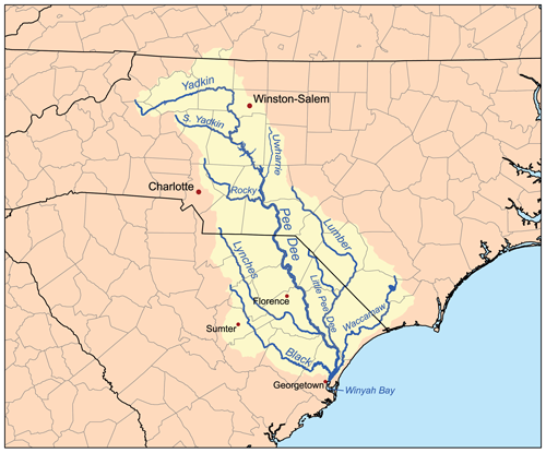
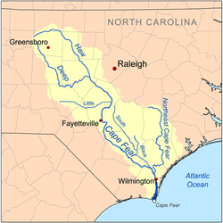
Then you had in the Cape Fear Basin ..and even the Santee on the other side ..that's a lot of water ...A lot
Last edited by wayoutfront on Sat Sep 15, 2018 2:41 pm, edited 2 times in total.
3 likes

Re: ATL: FLORENCE - Tropical Storm - Discussion
NDG wrote:According to radar estimates up to 45" have fallen in parts of central coastal NC, even if it is over doing it by 20% rainfalls in the 30+" is not out of the question
https://i.imgur.com/mByeuan.gif
I can see more than 50 inches of rain falling from Florence. Florence beats Floyd for sure.
5 likes

Re: ATL: FLORENCE - Tropical Storm - Discussion
Heavy bands starting to move into Charlotte. Gonna be a long night.
3 likes
-
tropicwatch

- Category 5
- Posts: 3205
- Age: 60
- Joined: Sat Jun 02, 2007 10:01 am
- Location: Panama City Florida
- Contact:
Re: ATL: FLORENCE - Tropical Storm - Discussion
1 likes
Tropicwatch
Agnes 72', Eloise 75, Elena 85', Kate 85', Charley 86', Florence 88', Beryl 94', Dean 95', Erin 95', Opal 95', Earl 98', Georges 98', Ivan 2004', Arlene 2005', Dennis 2005', Ida 2009' Debby 2012' Irma 2017' Michael 2018'
Agnes 72', Eloise 75, Elena 85', Kate 85', Charley 86', Florence 88', Beryl 94', Dean 95', Erin 95', Opal 95', Earl 98', Georges 98', Ivan 2004', Arlene 2005', Dennis 2005', Ida 2009' Debby 2012' Irma 2017' Michael 2018'
-
sittingduck

- S2K Supporter
- Posts: 107
- Joined: Mon Aug 13, 2007 3:16 pm
- Location: venice florida
Re: ATL: FLORENCE - Tropical Storm - Discussion
My thoughts, prayers and heart are with the people of the Carolinas. Flo just needs to move out. So sad with all the flooding
8 likes
-
cycloneye

- Admin

- Posts: 139069
- Age: 67
- Joined: Thu Oct 10, 2002 10:54 am
- Location: San Juan, Puerto Rico
Re: ATL: FLORENCE - Advisories
BULLETIN
Tropical Storm Florence Advisory Number 66
NWS National Hurricane Center Miami FL AL062018
500 PM EDT Sat Sep 15 2018
...CENTER OF FLORENCE CONTINUES ITS SLOW WESTWARD TREK ACROSS
EASTERN SOUTH CAROLINA...
...HEAVY RAINS AND CATASTROPHIC FLOODING CONTINUE ACROSS PORTIONS
OF NORTH CAROLINA AND SOUTH CAROLINA...
SUMMARY OF 500 PM EDT...2100 UTC...INFORMATION
----------------------------------------------
LOCATION...33.6N 79.9W
ABOUT 60 MI...95 KM W OF MYRTLE BEACH SOUTH CAROLINA
ABOUT 45 MI...70 KM SSW OF FLORENCE SOUTH CAROLINA
MAXIMUM SUSTAINED WINDS...45 MPH...75 KM/H
PRESENT MOVEMENT...W OR 270 DEGREES AT 2 MPH...4 KM/H
MINIMUM CENTRAL PRESSURE...997 MB...29.44 INCHES
Tropical Storm Florence Discussion Number 66
NWS National Hurricane Center Miami FL AL062018
500 PM EDT Sat Sep 15 2018
Florence's center has continued its slow...and I do mean s-l-o-w...
westward trek across eastern South Carolina, with little change in
the overall structure of the wind field both overland and over
water. NOAA WSR-88D Doppler weather radar data, surface
observations, and a 1527Z ASCAT pass indicate that Florence is
still producing a significant fetch of tropical storm force winds
within and adjacent to the the two bands of convection that are
currently located between the Cape Fear/Wilmington area and Bogue
Inlet, North Carolina. The ASCAT pass contained numerous 40-45 kt
wind vectors, and the NOAA NOS observing site at Johnny Mercer Pier
in Wrightsville Beach, North Carolina, has been reporting sustained
winds of 38-41 kt and gusts to 46-48 kt during the past few hours
during the passage of light to moderate rain showers. Therefore, the
initial intensity is being maintained at a conservative 40 kt for
this advisory. The estimated central pressure of 997 mb is based on
nearby surface observations across eastern South Carolina.
The initial motion remains 270/02 kt. The new 12Z model guidance
remains in excellent agreement on a mid-level ridge currently to the
northwest and north of Florence moving steadily eastward during the
next 48 hours, which will keep the broad cyclone moving slowly
westward to west-northwestward during that time. By 48 hours and
beyond, the ridge is forecast to continue to shift eastward to near
the northeast U.S. coast and weaken, which will allow Florence and
its remnant circulation to move slowly northward into the
mid-latitude westerlies by Tuesday. By days 3-5, the global models
diverge on where and how fast Florence's then extratropical
circulation moves. Due to the significant spread in the guidance,
the official forecast track lies close to the consensus model
TCVA/TVCN and the previous advisory track forecast.
Florence's inner-core convection and wind field will steadily weaken
throughout the next 48 hours or so. However, the outer wind
field and an associated band of deep convection in the eastern
semicircle should continue to produce tropical-storm-force winds
for another 12 hours or so over water and near the coast, with
occasional strong wind gusts occurring over land. The official
intensity forecast is close to an average of the Decay-SHIPS and
LGEM, and the IVCN consensus intensity model guidance through 72
hours, and then follows a blend of the IVCN, HCCA, and FSSE
consensus models at 96 and 120 hours when the post-tropical cyclone
moves back over water and strengthens some due to baroclinic
processes.
Although coastal storm surge flooding will continue to subside
tonight and Sunday, torrential rainfall will continue to be a
serious hazard associated with slow-moving Florence. More than two-
and-a-half feet of rain has already fallen across portions of
southeastern North Carolina, and more rain is still to come, which
will cause disastrous flooding that will spread farther inland
through the weekend.
Key Messages:
1. Life-threatening, catastrophic flash floods and prolonged
significant river flooding are likely over portions of the Carolinas
and the southern to central Appalachians from western North Carolina
into west-central Virginia and far eastern West Virginia through
early next week, as Florence moves slowly inland. In addition to the
flash flood and flooding threat, landslides are also possible in the
higher terrain of the southern and central Appalachians across
western North Carolina into southwest Virginia.
2. Water levels along the coast will gradually subside through
Sunday.
3. Tropical storm conditions will continue along the coast within
the tropical storm warning area and also well inland across portions
of South Carolina and North Carolina today.
4. Large swells affecting Bermuda, portions of the U.S. East Coast,
and the northwestern and central Bahamas will continue this week,
resulting in life-threatening surf and rip currents.
FORECAST POSITIONS AND MAX WINDS
INIT 15/2100Z 33.6N 79.9W 40 KT 45 MPH...INLAND
12H 16/0600Z 33.9N 80.9W 35 KT 40 MPH...INLAND
24H 16/1800Z 35.1N 82.6W 25 KT 30 MPH...INLAND
36H 17/0600Z 37.0N 83.2W 25 KT 30 MPH...INLAND
48H 17/1800Z 38.8N 82.1W 20 KT 25 MPH...POST-TROP/REMNT LOW
72H 18/1800Z 41.4N 74.5W 20 KT 25 MPH...POST-TROP/REMNT LOW
96H 19/1800Z 43.3N 60.8W 30 KT 35 MPH...POST-TROP/EXTRATROP
120H 20/1800Z 47.0N 47.0W 40 KT 45 MPH...POST-TROP/EXTRATROP
$$
Forecaster Stewart
0 likes
Visit the Caribbean-Central America Weather Thread where you can find at first post web cams,radars
and observations from Caribbean basin members Click Here
and observations from Caribbean basin members Click Here

Re: ATL: FLORENCE - Tropical Storm - Discussion
Looking at the visible, the storm appears to have drifted southeast over the past couple of hours.
0 likes
Who is online
Users browsing this forum: No registered users and 112 guests