
I bartend at an outside bar in Key West. It looks like I will be wearing rain boots and my fouly on Tuesday. Even if the system gets named before it gets here, all I expext is rain and a little wind. If named it will mean a bunch of hype.
That said, when this thing makes it to the gulf, I do think there is potential for some RI.
ATL: GORDON - Post-Tropical
Moderator: S2k Moderators
Re: ATL: INVEST 91L - Discussion
2 likes
-
Clearcloudz

- Category 2

- Posts: 523
- Joined: Sun Jun 10, 2018 1:46 pm
- Location: Rosenberg TX
Re: ATL: INVEST 91L - Discussion
We could see some advisories posted for southern Florida from the NHC as soon as this evening.
Organization is increasing with #91L this morning by the minute. We could have a depression within 24 hours if this continues.
https://twitter.com/hurrtrackerapp/status/1036254444441280512
Organization is increasing with #91L this morning by the minute. We could have a depression within 24 hours if this continues.
https://twitter.com/hurrtrackerapp/status/1036254444441280512
0 likes
-
Hypercane_Kyle

- Category 5

- Posts: 2900
- Joined: Sat Mar 07, 2015 7:58 pm
- Location: Cape Canaveral, FL
Re: ATL: INVEST 91L - Discussion
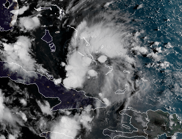
Definitely can see mid-level turning developing on satellite.
0 likes
My posts are my own personal opinion, defer to the National Hurricane Center (NHC) and other NOAA products for decision making during hurricane season.

Re: ATL: INVEST 91L - Discussion
drezee wrote:NDG wrote:Vorticity & organization is increasing this morning by the minute.
NDG, you beat me to the post...this is not looking good. Organizing quickly...
NDG, this is deja vu to the conversation on 8/23/17 on Harvey. I'm not saying it will bv e anything like Harvey. We were having bv the same posts about organizing by the min...and models playing catch up. No good
0 likes
Re: ATL: INVEST 91L - Discussion
Euro may also have to play catch up to itself...it showed a cat 1 earlier. It may have to come back to more intensity. Not the first time...
0 likes
-
jlauderdal
- S2K Supporter

- Posts: 6771
- Joined: Wed May 19, 2004 5:46 am
- Location: NE Fort Lauderdale
- Contact:
Re: RE: Re: ATL: INVEST 91L - Discussion
Looks decent on satellite but what's happening in the mid and lower levels is the key at this point
Sent from my SM-G950U using Tapatalk
Hypercane_Kyle wrote:Definitely can see mid-level turning developing on satellite.
Sent from my SM-G950U using Tapatalk
0 likes
-
Clearcloudz
- Category 2
- Posts: 523
- Joined: Sun Jun 10, 2018 1:46 pm
- Location: Rosenberg TX
Re: ATL: INVEST 91L - Discussion
A lot of people on the other forum starting writing off this storm as soon as the operational run came in for the 00Z EURO based off 1 run and these runs are based in the percentages of different scenarios on the ensemble spread. The 12Z run could easily come back stronger.
0 likes


Re: ATL: INVEST 91L - Discussion
Where is the center of circulation being pinpointed at right now? I see a lot of broad mid level rotation, but if an LLC were to develop, where are we thinking that it would develop?
0 likes
FSU '24 student pursuing a degree in meteorology. Consult NHC for official information.
-
tropicwatch

- Category 5
- Posts: 3205
- Age: 60
- Joined: Sat Jun 02, 2007 10:01 am
- Location: Panama City Florida
- Contact:
Re: ATL: INVEST 91L - Discussion
91L becoming a good looking system.
2 likes
Tropicwatch
Agnes 72', Eloise 75, Elena 85', Kate 85', Charley 86', Florence 88', Beryl 94', Dean 95', Erin 95', Opal 95', Earl 98', Georges 98', Ivan 2004', Arlene 2005', Dennis 2005', Ida 2009' Debby 2012' Irma 2017' Michael 2018'
Agnes 72', Eloise 75, Elena 85', Kate 85', Charley 86', Florence 88', Beryl 94', Dean 95', Erin 95', Opal 95', Earl 98', Georges 98', Ivan 2004', Arlene 2005', Dennis 2005', Ida 2009' Debby 2012' Irma 2017' Michael 2018'

Re: ATL: INVEST 91L - Discussion
NDG wrote:SoupBone wrote:So what am I missing as to why the GFS seems to be being under-considered at this point? There's a huge split between the Euro and GFS.
Very simple, it has been playing catch up with the Euro all this time, just a day-two ago was showing no development at all.
Thanks NDG, I'm asking more about the hook NE vs meandering around the coast toward Texas. This seems to be the biggest ? at the moment.
0 likes
Personal Forecast Disclaimer:
The posts in this forum are NOT official forecast and should not be used as such. They are just the opinion of the poster and may or may not be backed by sound meteorological data. They are NOT endorsed by any professional institution or storm2k.org. For official information, please refer to the NHC and NWS products.
The posts in this forum are NOT official forecast and should not be used as such. They are just the opinion of the poster and may or may not be backed by sound meteorological data. They are NOT endorsed by any professional institution or storm2k.org. For official information, please refer to the NHC and NWS products.
-
MGC

- S2K Supporter
- Posts: 5792
- Joined: Sun Mar 23, 2003 9:05 pm
- Location: Pass Christian MS, or what is left.
Re: ATL: INVEST 91L - Discussion
I think the Euro is closing 91L off too quickly. I don't see closed isobars till 91L gets into the GOM. Does appear to have a decent MLC setting up but should take some time to reach the surface....MGC
0 likes
-
GeneratorPower

- S2K Supporter
- Posts: 1648
- Age: 44
- Joined: Sun Dec 18, 2005 11:48 pm
- Location: Huntsville, AL

Re: ATL: INVEST 91L - Discussion
Looks like a developing TC to me. Give it another day or three.
5 likes
Re: ATL: INVEST 91L - Discussion
RL3AO wrote:Looks like a developing TC to me. Give it another day or three.
Tongue in cheek?
0 likes
Personal Forecast Disclaimer:
The posts in this forum are NOT official forecast and should not be used as such. They are just the opinion of the poster and may or may not be backed by sound meteorological data. They are NOT endorsed by any professional institution or storm2k.org. For official information, please refer to the NHC and NWS products.
The posts in this forum are NOT official forecast and should not be used as such. They are just the opinion of the poster and may or may not be backed by sound meteorological data. They are NOT endorsed by any professional institution or storm2k.org. For official information, please refer to the NHC and NWS products.
Re: ATL: INVEST 91L - Discussion
I’ll be very curious to see the 2pm TWO to see if they bump up that 30 percent.
0 likes
Re: ATL: INVEST 91L - Discussion
This system has the right look at the right time of the year. It's always amazing how stuff snaps together under less than perfect conditions at peak season and is another good reminder to disregard long term model solutions showing zip during peak season...something almost always slips past the goalie. I continue to think the odds favor an eventual TS out of this. Hopefully it moves along and is a "fun" storm for whoever eventually gets it
4 likes
-
cycloneye

- Admin

- Posts: 139094
- Age: 67
- Joined: Thu Oct 10, 2002 10:54 am
- Location: San Juan, Puerto Rico
Re: ATL: INVEST 91L - Discussion
tgenius wrote:I’ll be very curious to see the 2pm TWO to see if they bump up that 30 percent.
Is now at 50% in 2 days.
1 likes
Visit the Caribbean-Central America Weather Thread where you can find at first post web cams,radars
and observations from Caribbean basin members Click Here
and observations from Caribbean basin members Click Here
Re: ATL: INVEST 91L - Discussion
cycloneye wrote:tgenius wrote:I’ll be very curious to see the 2pm TWO to see if they bump up that 30 percent.
Is now at 50% in 2 days.
Ok Luis. Sorry hadn’t seen it since last night.
0 likes
-
HurricaneEric
- Tropical Storm

- Posts: 146
- Age: 29
- Joined: Mon Sep 07, 2015 11:06 am
- Location: Miami, FL
Re: ATL: INVEST 91L - Discussion
Agreed this looks better organized (at least in the mid levels). That being said, I have a question for some of the pro Mets or experts on here: what is the usual time table for mid level organization to transfer down to the surface?
Of course, this is under the assumption that a system finds a favorable pocket of atmospheric conditions as 91L seems to have had here...
Of course, this is under the assumption that a system finds a favorable pocket of atmospheric conditions as 91L seems to have had here...
2 likes
Irene '99, Katrina '05, Wilma '05, Irma '17 (storms I remember my area getting hurricane force winds/gusts).
The posts in this forum are NOT official forecast and shouldn't be used as such. They are just the opinion of the poster and may or may not be backed by sound meteorological data. For official information, please refer to the experts.
The posts in this forum are NOT official forecast and shouldn't be used as such. They are just the opinion of the poster and may or may not be backed by sound meteorological data. For official information, please refer to the experts.
-
Shell Mound
- Category 5
- Posts: 2434
- Age: 31
- Joined: Thu Sep 07, 2017 3:39 pm
- Location: St. Petersburg, FL → Scandinavia
Re: ATL: INVEST 91L - Discussion
MGC wrote:I think the Euro is closing 91L off too quickly. I don't see closed isobars till 91L gets into the GOM. Does appear to have a decent MLC setting up but should take some time to reach the surface....MGC
Respectfully, I disagree. Recent visible imagery suggests that a low-level centre is very close to formation, based on favourable and expanding anticyclonic outflow, along with ample low-level convergence. Additionally, the small size of the mid-level vortex is helping the system develop despite its proximity to the retrograding upper low. The shear vectors are actually venting 91L rather than shearing it at this time, and conditions will only improve later today and over the next several days. The compact size of the system and sufficiently moist conditions suggest that a depression or even a weak tropical storm could rapidly develop overnight and then intensify rapidly near/over the Keys and southeastern Gulf of Mexico. Note that all the global models indicate that whatever forms will remain relatively compact, embedded in high environmental pressures, which could aid rapid intensification should an inner core develop at any point.
5 likes
CVW / MiamiensisWx / Shell Mound
The posts in this forum are NOT official forecasts and should not be used as such. They are just the opinion of the poster and may or may not be backed by sound meteorological data. They are NOT endorsed by any professional institution or STORM2K. For official information, please refer to products from the NHC and NWS.
Who is online
Users browsing this forum: No registered users and 25 guests