
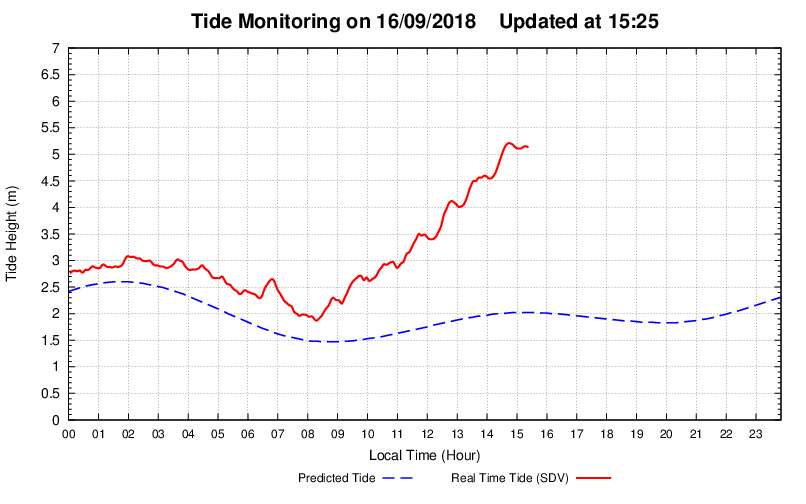
About 5.2 m or 17 feet for those still on the imperial system. Big probs for low lying sea level areas
WPAC: MANGKHUT - Post-Tropical
Moderator: S2k Moderators
Re: WPAC: MANGKHUT - Typhoon
About 5.2 m or 17 feet for those still on the imperial system. Big probs for low lying sea level areas
0 likes

Re: WPAC: MANGKHUT - Typhoon
Joe_1 wrote:
About 5.2 m or 17 feet for those still on the imperial system. Big probs for low lying sea level areas
Victoria Harbor looked like the ocean. The waves were incredible. Flooding over the wall behind the Kerry Hotel.
0 likes
-
cycloneye

- Admin

- Posts: 139212
- Age: 67
- Joined: Thu Oct 10, 2002 10:54 am
- Location: San Juan, Puerto Rico
Re: WPAC: MANGKHUT - Typhoon
0 likes
Visit the Caribbean-Central America Weather Thread where you can find at first post web cams,radars
and observations from Caribbean basin members Click Here
and observations from Caribbean basin members Click Here

Re: WPAC: MANGKHUT - Typhoon
Incredible. First time i've seen the videos of this. Super strong! Looks like it was underestimated...
0 likes
Remember, all of my post aren't official. For official warnings and discussions, Please refer to your local NWS products...
NWS for the Western Pacific
https://www.weather.gov/gum/
NWS for the Western Pacific
https://www.weather.gov/gum/
-
cycloneye
- Admin
- Posts: 139212
- Age: 67
- Joined: Thu Oct 10, 2002 10:54 am
- Location: San Juan, Puerto Rico
Re: WPAC: MANGKHUT - Typhoon
0 likes
Visit the Caribbean-Central America Weather Thread where you can find at first post web cams,radars
and observations from Caribbean basin members Click Here
and observations from Caribbean basin members Click Here


-
NotoSans
- Category 5

- Posts: 1366
- Age: 24
- Joined: Sun Sep 27, 2015 1:15 am
- Location: Hong Kong
- Contact:
Re: WPAC: MANGKHUT - Typhoon
This is a video for Typhoon Muidage.
0 likes
Personal Forecast Disclaimer:
The posts in this forum are NOT official forecast and should not be used as such. They are just the opinion of the poster and may or may not be backed by sound meteorological data. They are NOT endorsed by any professional institution or storm2k.org. For official information, please refer to RSMC and NWS products.
The posts in this forum are NOT official forecast and should not be used as such. They are just the opinion of the poster and may or may not be backed by sound meteorological data. They are NOT endorsed by any professional institution or storm2k.org. For official information, please refer to RSMC and NWS products.
-
NotoSans
- Category 5
- Posts: 1366
- Age: 24
- Joined: Sun Sep 27, 2015 1:15 am
- Location: Hong Kong
- Contact:
Re: WPAC: MANGKHUT - Typhoon
The major roads and railways in Hong Kong are all blocked by collapsed trees. Even if the No.10 Hurricane Signal has been lowered, there's still major problem going on with the Hong Kong transport right now.
1 likes
Personal Forecast Disclaimer:
The posts in this forum are NOT official forecast and should not be used as such. They are just the opinion of the poster and may or may not be backed by sound meteorological data. They are NOT endorsed by any professional institution or storm2k.org. For official information, please refer to RSMC and NWS products.
The posts in this forum are NOT official forecast and should not be used as such. They are just the opinion of the poster and may or may not be backed by sound meteorological data. They are NOT endorsed by any professional institution or storm2k.org. For official information, please refer to RSMC and NWS products.
-
mrbagyo

- Category 5
- Posts: 3615
- Age: 31
- Joined: Thu Apr 12, 2012 9:18 am
- Location: 14.13N 120.98E
- Contact:
Re: WPAC: MANGKHUT - Typhoon
0 likes
The posts in this forum are NOT official forecast and should not be used as such. They are just the opinion of the poster and may or may not be backed by sound meteorological data. They are NOT endorsed by any professional institution or storm2k.org. For official information, please refer to RSMC, NHC and NWS products.
-
mrbagyo
- Category 5
- Posts: 3615
- Age: 31
- Joined: Thu Apr 12, 2012 9:18 am
- Location: 14.13N 120.98E
- Contact:
Re: WPAC: MANGKHUT - Typhoon
0 likes
The posts in this forum are NOT official forecast and should not be used as such. They are just the opinion of the poster and may or may not be backed by sound meteorological data. They are NOT endorsed by any professional institution or storm2k.org. For official information, please refer to RSMC, NHC and NWS products.
-
supercane4867
- Category 5
- Posts: 4966
- Joined: Wed Nov 14, 2012 10:43 am
Re: WPAC: MANGKHUT - Typhoon
Just called my grandma in Shenzhen. She said all windows were blown off and everything in the home became a mess. She lives at 10th floor on a high rise apartment. Thankfully she is okay. The city is surrounded by mountains that usually block the most intense winds from typhoons yet still experienced hell. Can't imagine how bad things are in Hong Kong.
1 likes
-
supercane4867
- Category 5
- Posts: 4966
- Joined: Wed Nov 14, 2012 10:43 am

Re: WPAC: MANGKHUT - Typhoon
It seems that the agencies underestimated Mangkhut intensity, and I don't blame them, it looked ragged in satellite. Wish we could have recon in the WPAC.
0 likes
-
1900hurricane

- Category 5
- Posts: 6044
- Age: 33
- Joined: Fri Feb 06, 2015 12:04 pm
- Location: Houston, TX
- Contact:
Re: WPAC: MANGKHUT - Typhoon
Worth noting that there was pretty big disagreement between the AMSU and ATMS intensity estimates while over the South China Sea (black circle). I also want to point out how consistent the microwave intensity estimates were for the several days prior to Luzon landfall (along/under green line). This is possibly a big win for microwave intensity estimates in intense tropical cyclones.

0 likes
Contract Meteorologist. TAMU & MSST. Fiercely authentic, one of a kind. We are all given free will, so choose a life meant to be lived. We are the Masters of our own Stories.
Opinions expressed are mine alone.
Follow me on Twitter at @1900hurricane : Read blogs at https://1900hurricane.wordpress.com/
Opinions expressed are mine alone.
Follow me on Twitter at @1900hurricane : Read blogs at https://1900hurricane.wordpress.com/
-
NotoSans
- Category 5
- Posts: 1366
- Age: 24
- Joined: Sun Sep 27, 2015 1:15 am
- Location: Hong Kong
- Contact:
Re: WPAC: MANGKHUT - Typhoon
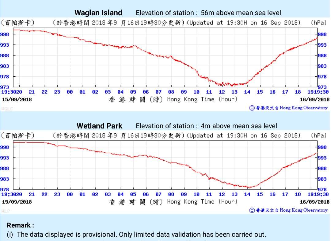
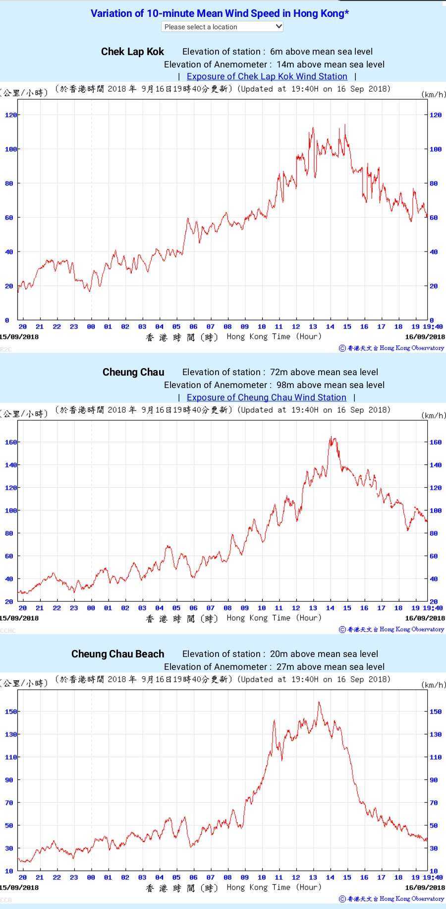
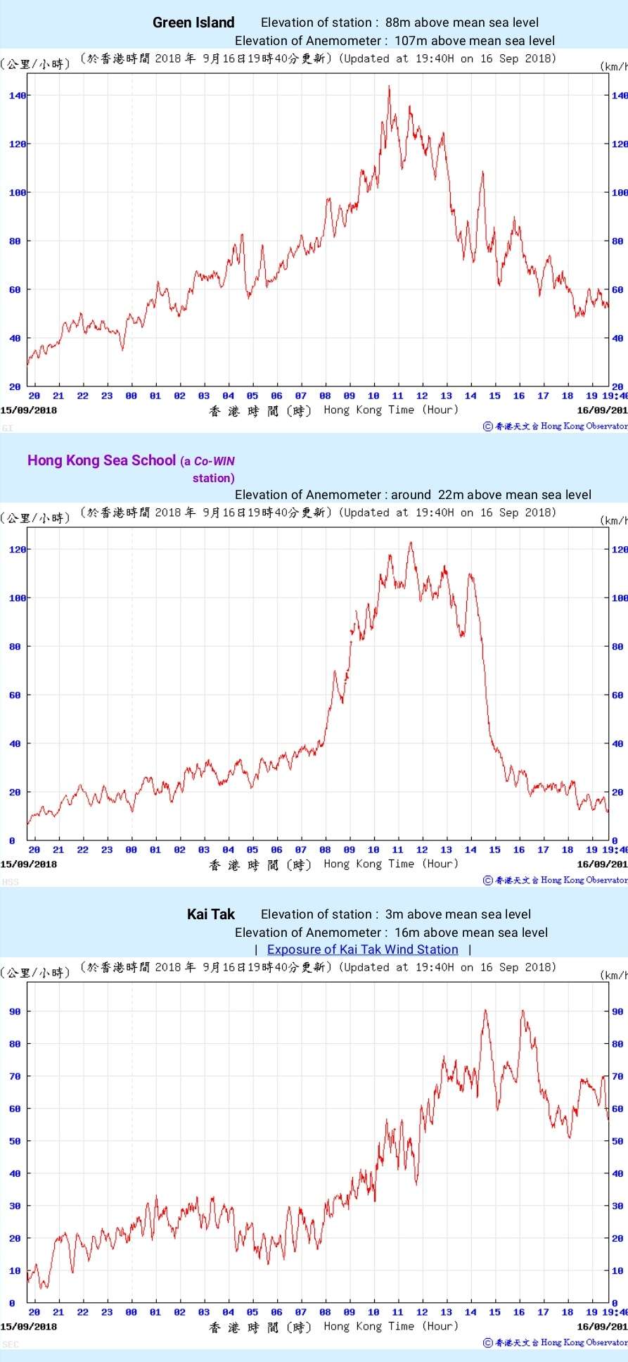
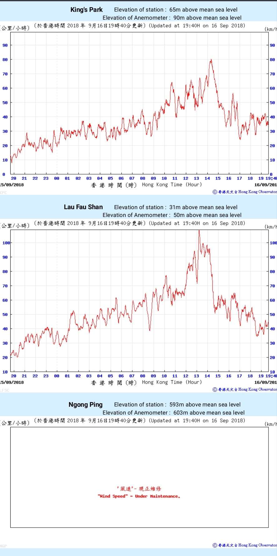
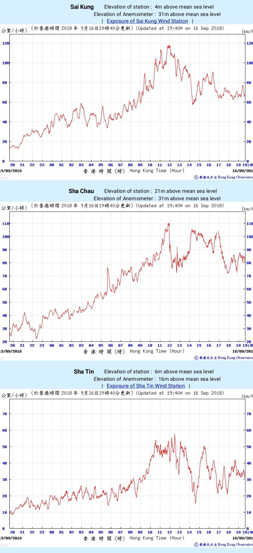
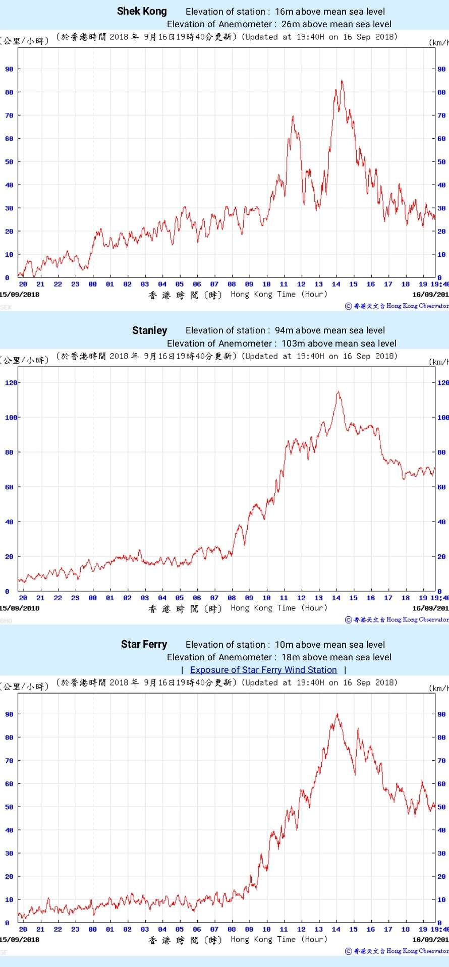
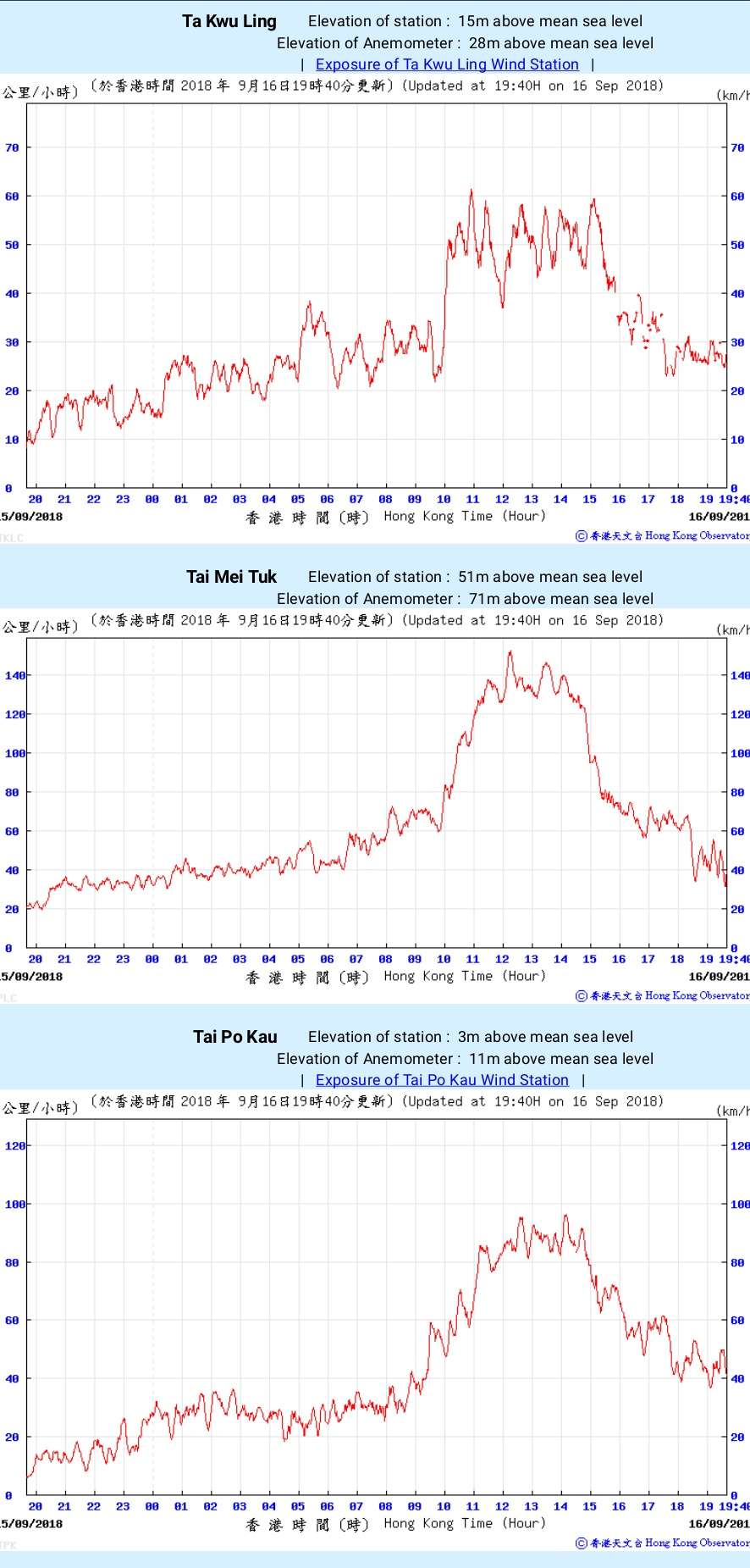
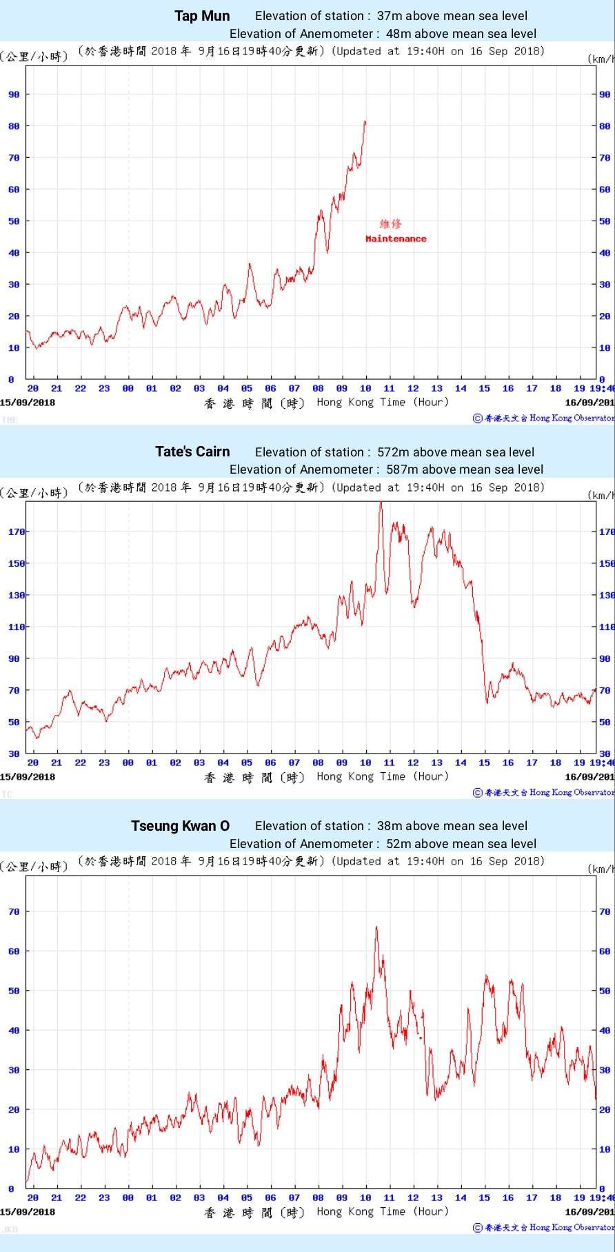
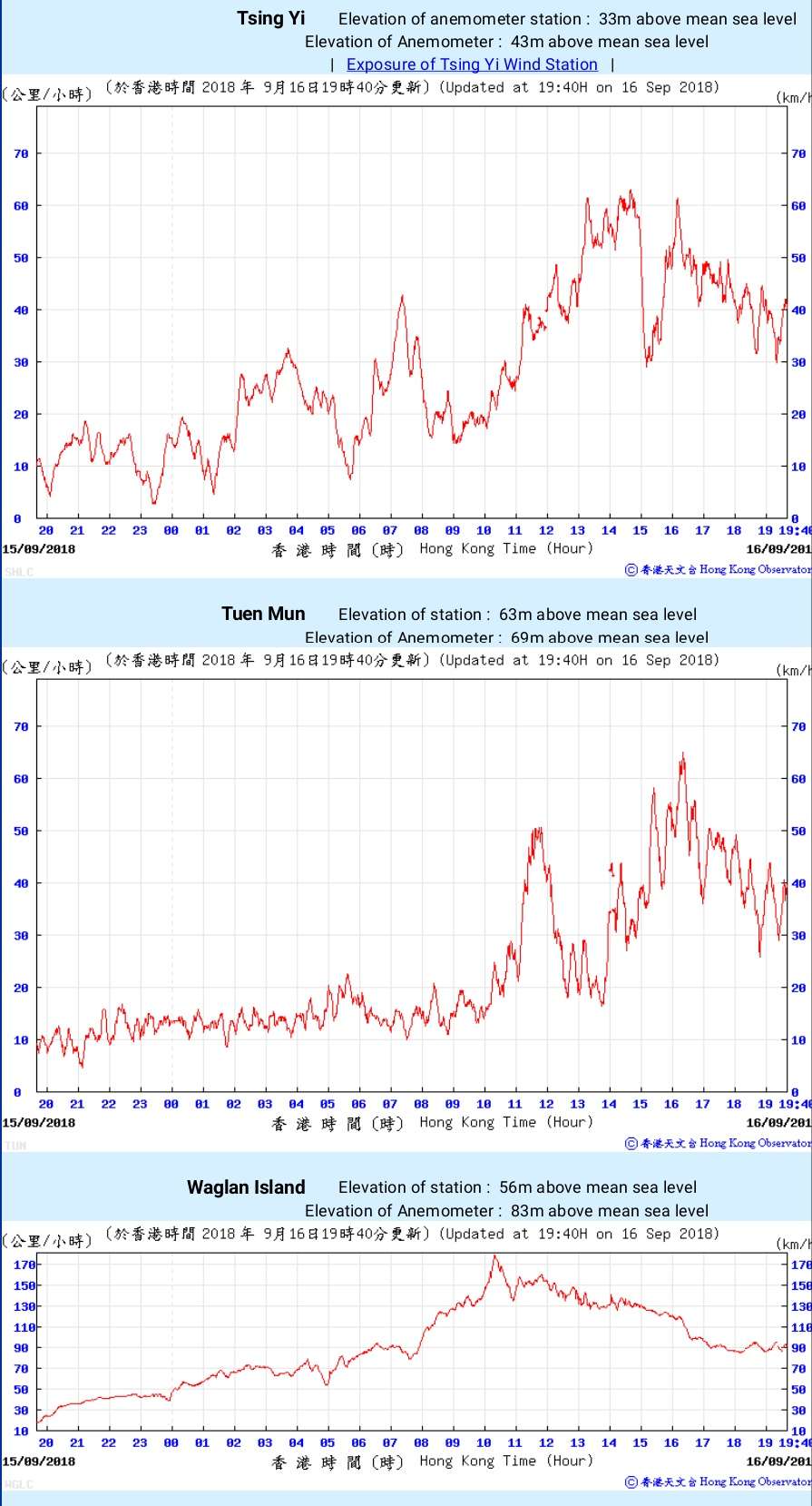
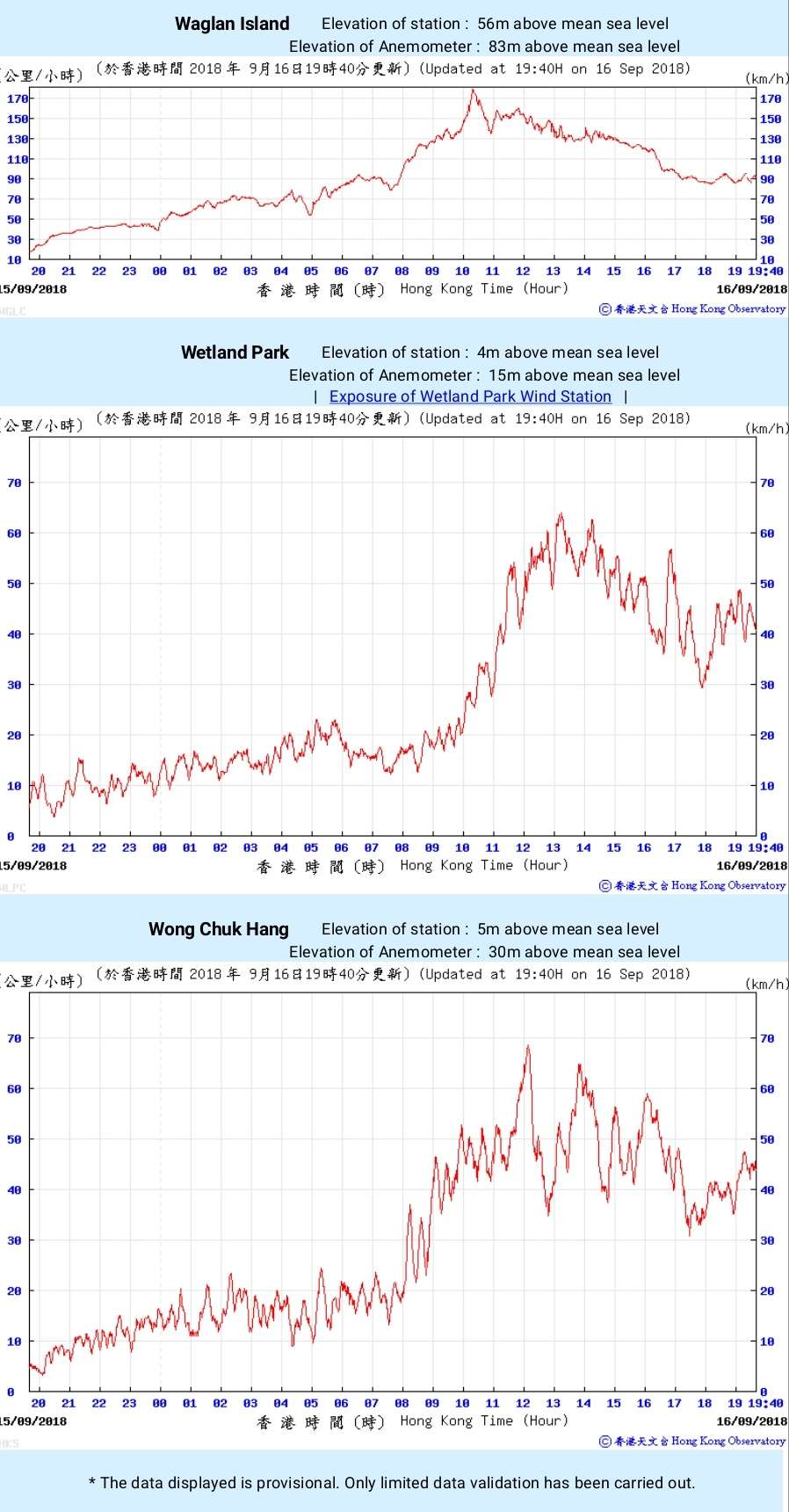
Sustained hurricane-force winds were recorded by various weather stations (most of them being outlying islands or elevated areas) in Hong Kong, and the data are as follows:
Tate's Cairn (587m above sea level): 102.2 knots
Waglan Island (83m above sea level): 97.0 knots
Cheung Chau (98m above sea level): 89.2 knots
Cheung Chau Beach (27m above sea level): 85.7 knots
Tai Mei Tuk (71m above sea level): 82.4 knots
Green Island (107m above sea level): 77.8 knots
Hong Kong Sea School (22m above sea level): 66.5 knots
Overall, Hong Kong was affected by sustained storm-force to hurricane-force winds for around 6 hours, and the wind data recorded are the highest since Typhoon Ellen in 1983.
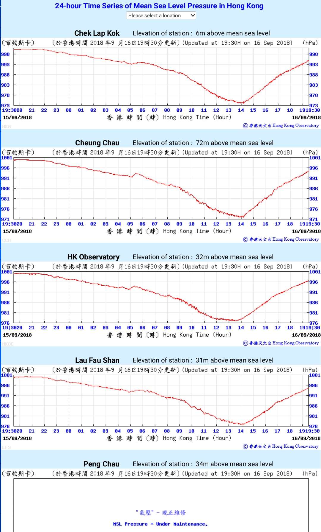
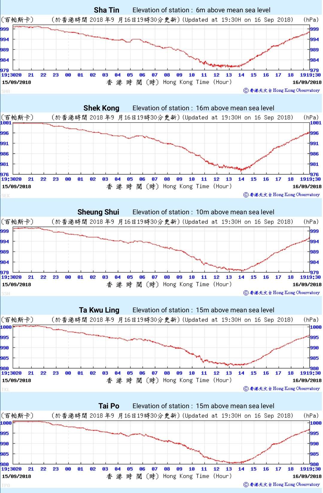
Storm surge was also very significant in Hong Kong. Tai Po Kau recorded a maximum tidal height of 4.69m above chart datum (second highest on record) and a storm surge of 3.38m (highest on record). Quarry Bay also had a record storm surge of 2.26m. Overall, the storm surge was as significant as Typhoon Hato last year. Fortunately, Typhoon Mangkhut did not coincide with the astronomical high tides; otherwise, the storm surge would be way more significant.
Tate's Cairn (587m above sea level): 102.2 knots
Waglan Island (83m above sea level): 97.0 knots
Cheung Chau (98m above sea level): 89.2 knots
Cheung Chau Beach (27m above sea level): 85.7 knots
Tai Mei Tuk (71m above sea level): 82.4 knots
Green Island (107m above sea level): 77.8 knots
Hong Kong Sea School (22m above sea level): 66.5 knots
Overall, Hong Kong was affected by sustained storm-force to hurricane-force winds for around 6 hours, and the wind data recorded are the highest since Typhoon Ellen in 1983.
Storm surge was also very significant in Hong Kong. Tai Po Kau recorded a maximum tidal height of 4.69m above chart datum (second highest on record) and a storm surge of 3.38m (highest on record). Quarry Bay also had a record storm surge of 2.26m. Overall, the storm surge was as significant as Typhoon Hato last year. Fortunately, Typhoon Mangkhut did not coincide with the astronomical high tides; otherwise, the storm surge would be way more significant.
3 likes
Personal Forecast Disclaimer:
The posts in this forum are NOT official forecast and should not be used as such. They are just the opinion of the poster and may or may not be backed by sound meteorological data. They are NOT endorsed by any professional institution or storm2k.org. For official information, please refer to RSMC and NWS products.
The posts in this forum are NOT official forecast and should not be used as such. They are just the opinion of the poster and may or may not be backed by sound meteorological data. They are NOT endorsed by any professional institution or storm2k.org. For official information, please refer to RSMC and NWS products.
-
NotoSans
- Category 5
- Posts: 1366
- Age: 24
- Joined: Sun Sep 27, 2015 1:15 am
- Location: Hong Kong
- Contact:
Re: WPAC: MANGKHUT - Tropical Storm
Adjusting the surface observations mentioned in the post above based on the vertical wind profile obtained from dropsondes, the maximum sustained winds affecting Hong Kong were likely around 75 to 80 knots (10-minute average).
It is worth mentioning that the maximum winds seemed to be displaced well away from the center due to the ERC, and weather stations affected by the inner eye did not record winds as high as those affected by the outer one. Thus, I would argue that surface observations in Hong Kong are representative of the maximum intensity of MANGKHUT.
As a side note, minimal pressure recorded near the landfall area was around 960 mb, which was also consistent with a low-end category 2 intensity.
Again, what makes MANGKHUT particularly dangerous was its expansive wind field, which caused Hong Kong to be affected by high winds for a long period of time and also led to significant storm surge.
1 likes
Personal Forecast Disclaimer:
The posts in this forum are NOT official forecast and should not be used as such. They are just the opinion of the poster and may or may not be backed by sound meteorological data. They are NOT endorsed by any professional institution or storm2k.org. For official information, please refer to RSMC and NWS products.
The posts in this forum are NOT official forecast and should not be used as such. They are just the opinion of the poster and may or may not be backed by sound meteorological data. They are NOT endorsed by any professional institution or storm2k.org. For official information, please refer to RSMC and NWS products.
-
1900hurricane
- Category 5
- Posts: 6044
- Age: 33
- Joined: Fri Feb 06, 2015 12:04 pm
- Location: Houston, TX
- Contact:
Re: WPAC: MANGKHUT - Severe Tropical Storm
That's about 85-91 kt for those more accustomed to 1 minute sustained winds when using the standard 0.88 conversion.
0 likes
Contract Meteorologist. TAMU & MSST. Fiercely authentic, one of a kind. We are all given free will, so choose a life meant to be lived. We are the Masters of our own Stories.
Opinions expressed are mine alone.
Follow me on Twitter at @1900hurricane : Read blogs at https://1900hurricane.wordpress.com/
Opinions expressed are mine alone.
Follow me on Twitter at @1900hurricane : Read blogs at https://1900hurricane.wordpress.com/
Re: WPAC: MANGKHUT - Typhoon
Macrocane wrote:It seems that the agencies underestimated Mangkhut intensity, and I don't blame them, it looked ragged in satellite. Wish we could have recon in the WPAC.
Prove that looks aren't everything. Damn this caught everyone off guard. Much stronger than they thought in those areas.
0 likes
Remember, all of my post aren't official. For official warnings and discussions, Please refer to your local NWS products...
NWS for the Western Pacific
https://www.weather.gov/gum/
NWS for the Western Pacific
https://www.weather.gov/gum/
-
mrbagyo
- Category 5
- Posts: 3615
- Age: 31
- Joined: Thu Apr 12, 2012 9:18 am
- Location: 14.13N 120.98E
- Contact:
Re: WPAC: MANGKHUT - Severe Tropical Storm
https://twitter.com/iCyclone/status/1041503848483962880
https://twitter.com/iCyclone/status/1041503901093187585
https://twitter.com/iCyclone/status/1041504016948183040
https://twitter.com/iCyclone/status/1041504291599654913
https://twitter.com/iCyclone/status/1041504907709349888
https://twitter.com/iCyclone/status/1041503901093187585
https://twitter.com/iCyclone/status/1041504016948183040
https://twitter.com/iCyclone/status/1041504291599654913
https://twitter.com/iCyclone/status/1041504907709349888
2 likes
The posts in this forum are NOT official forecast and should not be used as such. They are just the opinion of the poster and may or may not be backed by sound meteorological data. They are NOT endorsed by any professional institution or storm2k.org. For official information, please refer to RSMC, NHC and NWS products.
-
NotoSans
- Category 5
- Posts: 1366
- Age: 24
- Joined: Sun Sep 27, 2015 1:15 am
- Location: Hong Kong
- Contact:
Re: WPAC: MANGKHUT - Typhoon
euro6208 wrote:Macrocane wrote:It seems that the agencies underestimated Mangkhut intensity, and I don't blame them, it looked ragged in satellite. Wish we could have recon in the WPAC.
Prove that looks aren't everything. Damn this caught everyone off guard. Much stronger than they thought in those areas.
Hong Kong is VERY well-prepared for this storm. The government has even initiated evacuation plans for low-lying areas due to the potential storm surge, which was never seen before. The intensity forecast all showed a stronger storm than the reality.
Last edited by NotoSans on Mon Sep 17, 2018 9:19 am, edited 1 time in total.
1 likes
Personal Forecast Disclaimer:
The posts in this forum are NOT official forecast and should not be used as such. They are just the opinion of the poster and may or may not be backed by sound meteorological data. They are NOT endorsed by any professional institution or storm2k.org. For official information, please refer to RSMC and NWS products.
The posts in this forum are NOT official forecast and should not be used as such. They are just the opinion of the poster and may or may not be backed by sound meteorological data. They are NOT endorsed by any professional institution or storm2k.org. For official information, please refer to RSMC and NWS products.
Who is online
Users browsing this forum: No registered users and 25 guests