WPAC: KONG-Rey - Post-Tropical
Moderator: S2k Moderators

WPAC: KONG-Rey - Post-Tropical
94W INVEST 180922 1200 10.0N 160.0E WPAC 15 0
Last edited by Hayabusa on Sat Sep 29, 2018 3:27 pm, edited 2 times in total.
0 likes
ヤンデレ女が寝取られるているのを見たい!!!
ECMWF ensemble NWPAC plots: https://ecmwfensnwpac.imgbb.com/
Multimodel NWPAC plots: https://multimodelnwpac.imgbb.com/
GFS Ensemble NWPAC plots (16 & 35 day forecast): https://gefsnwpac.imgbb.com/
Plots updated automatically
ECMWF ensemble NWPAC plots: https://ecmwfensnwpac.imgbb.com/
Multimodel NWPAC plots: https://multimodelnwpac.imgbb.com/
GFS Ensemble NWPAC plots (16 & 35 day forecast): https://gefsnwpac.imgbb.com/
Plots updated automatically
Re: WPAC: INVEST 94W
There seems to be model support for 94W but it's in the long range and its development may be affected based on how Trami tracks
0 likes
ヤンデレ女が寝取られるているのを見たい!!!
ECMWF ensemble NWPAC plots: https://ecmwfensnwpac.imgbb.com/
Multimodel NWPAC plots: https://multimodelnwpac.imgbb.com/
GFS Ensemble NWPAC plots (16 & 35 day forecast): https://gefsnwpac.imgbb.com/
Plots updated automatically
ECMWF ensemble NWPAC plots: https://ecmwfensnwpac.imgbb.com/
Multimodel NWPAC plots: https://multimodelnwpac.imgbb.com/
GFS Ensemble NWPAC plots (16 & 35 day forecast): https://gefsnwpac.imgbb.com/
Plots updated automatically
-
ManilaTC

- WesternPacificWeather.com

- Posts: 592
- Age: 45
- Joined: Mon Oct 26, 2009 5:13 am
- Location: Mandaluyong City, Philippines
- Contact:
Re: WPAC: INVEST 94W
94W INVEST 180923 0000 10.4N 158.2E WPAC 15 1010
0 likes
The above post is NOT official and should not be used as such. It is my opinion and may or may not be backed by sound meteorological data. It is not endorsed by any professional institution or storm2k.org. Please refer to your official national weather agency.
WEB http://goo.gl/JDiKXB | FB https://goo.gl/N5sIle | @ManilaTC
WEB http://goo.gl/JDiKXB | FB https://goo.gl/N5sIle | @ManilaTC
Re: WPAC: INVEST 94W
JMA 6Z
LOW PRESSURE AREA 1006 HPA NEAR 12N 162E WNW SLOWLY.
BT 12Z
94W INVEST 180923 1200 10.7N 161.3E WPAC 15 1004
LOW PRESSURE AREA 1006 HPA NEAR 12N 162E WNW SLOWLY.
BT 12Z
94W INVEST 180923 1200 10.7N 161.3E WPAC 15 1004
0 likes
ヤンデレ女が寝取られるているのを見たい!!!
ECMWF ensemble NWPAC plots: https://ecmwfensnwpac.imgbb.com/
Multimodel NWPAC plots: https://multimodelnwpac.imgbb.com/
GFS Ensemble NWPAC plots (16 & 35 day forecast): https://gefsnwpac.imgbb.com/
Plots updated automatically
ECMWF ensemble NWPAC plots: https://ecmwfensnwpac.imgbb.com/
Multimodel NWPAC plots: https://multimodelnwpac.imgbb.com/
GFS Ensemble NWPAC plots (16 & 35 day forecast): https://gefsnwpac.imgbb.com/
Plots updated automatically

Re: WPAC: INVEST 94W
Good agreement between EURO and GFS on this developing.


0 likes
Remember, all of my post aren't official. For official warnings and discussions, Please refer to your local NWS products...
NWS for the Western Pacific
https://www.weather.gov/gum/
NWS for the Western Pacific
https://www.weather.gov/gum/
Re: WPAC: INVEST 94W
I don't think imo 94W is what they are developing the model storm^ they are developing comes way below latitude compared to the location of 94W, unless 94W would be relocated way below south of its current location
Here is latest BT
94W INVEST 180923 1800 10.5N 158.1E WPAC 15 1010
But the GFS and other models start the model storm development around 4-5N
Here is latest BT
94W INVEST 180923 1800 10.5N 158.1E WPAC 15 1010
But the GFS and other models start the model storm development around 4-5N
0 likes
ヤンデレ女が寝取られるているのを見たい!!!
ECMWF ensemble NWPAC plots: https://ecmwfensnwpac.imgbb.com/
Multimodel NWPAC plots: https://multimodelnwpac.imgbb.com/
GFS Ensemble NWPAC plots (16 & 35 day forecast): https://gefsnwpac.imgbb.com/
Plots updated automatically
ECMWF ensemble NWPAC plots: https://ecmwfensnwpac.imgbb.com/
Multimodel NWPAC plots: https://multimodelnwpac.imgbb.com/
GFS Ensemble NWPAC plots (16 & 35 day forecast): https://gefsnwpac.imgbb.com/
Plots updated automatically
Re: WPAC: INVEST 94W
Looks like theres a glitch. All storms in the WPAC disappeared on BT and the Navy site.
0 likes
Remember, all of my post aren't official. For official warnings and discussions, Please refer to your local NWS products...
NWS for the Western Pacific
https://www.weather.gov/gum/
NWS for the Western Pacific
https://www.weather.gov/gum/
Re: WPAC: INVEST 94W
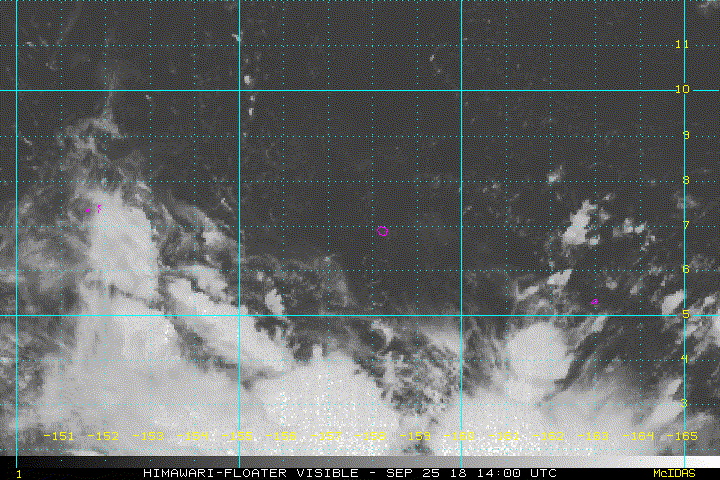
94W INVEST 180925 0000 8.7N 158.7E WPAC 15 1007
I still don't believe this is the one models are developing, models start to develop it below 5N, unless 94W gets relocated even further south, or around below 5N
I still don't believe this is the one models are developing, models start to develop it below 5N, unless 94W gets relocated even further south, or around below 5N
0 likes
ヤンデレ女が寝取られるているのを見たい!!!
ECMWF ensemble NWPAC plots: https://ecmwfensnwpac.imgbb.com/
Multimodel NWPAC plots: https://multimodelnwpac.imgbb.com/
GFS Ensemble NWPAC plots (16 & 35 day forecast): https://gefsnwpac.imgbb.com/
Plots updated automatically
ECMWF ensemble NWPAC plots: https://ecmwfensnwpac.imgbb.com/
Multimodel NWPAC plots: https://multimodelnwpac.imgbb.com/
GFS Ensemble NWPAC plots (16 & 35 day forecast): https://gefsnwpac.imgbb.com/
Plots updated automatically
Re: WPAC: INVEST 94W
Seems like JTWC sees this develop but see the highlighted statement
(2) AN AREA OF CONVECTION (INVEST 94W) HAS PERSISTED NEAR 7.9N
157.7E, APPROXIMATELY 70 NM NORTH-NORTHWEST OF POHNPEI, FEDERATED
STATES OF MICRONESIA. ANIMATED MULTISPECTRAL SATELLITE IMAGERY
DEPICTS A LARGE, EXPOSED LOW-LEVEL CIRCULATION WITH PERSISTENT YET
DISORGANIZED DEEP CONVECTION FLARING OVER THE SOUTHERN PERIPHERY. A
250245Z AMSR2 89GHZ IMAGE INDICATES A POORLY DEFINED LOW-LEVEL
CIRCULATION CENTER (LLCC) WITH VERY WEAK CONVECTIVE STRUCTURE.
SURFACE OBSERVATIONS FROM POHNPEI REVEAL SOUTHERLY WINDS AT 5 KNOTS
AND SLP NEAR 1006MB. A 242234Z ASCAT IMAGE SHOWS AN ELONGATED,
DEFINED CIRCULATION WITH 20-25 KNOT CONVERGENT WESTERLY WINDS OVER
THE SOUTHERN SEMICIRCLE AND 10-15 KNOT EASTERLY WINDS OVER THE
NORTHERN SEMICIRCLE. UPPER-LEVEL ANALYSIS DEPICTS A MARGINAL
ENVIRONMENT WITH A BROAD INVERTED TROUGH AND CONVERGENT FLOW OVER
THE SYSTEM OFFSET BY WEAK DIFFLUENCE. GLOBAL MODELS INDICATE A
DISTINCT LLCC WILL DEVELOP AND CONSOLIDATE WITHIN THE SOUTHERN
PERIPHERY OF THIS LARGE CIRCULATION OVER THE NEXT 1-2 DAYS WITH
SIGNIFICANT DEVELOPMENT AS THE SYSTEM TRACKS NORTHWESTWARD TOWARD
GUAM AFTER DAY TWO. MAXIMUM SUSTAINED SURFACE WINDS ARE ESTIMATED AT
10 TO 15 KNOTS. MINIMUM SEA LEVEL PRESSURE IS ESTIMATED TO BE NEAR
1006 MB. THE POTENTIAL FOR THE DEVELOPMENT OF A SIGNIFICANT TROPICAL
CYCLONE WITHIN THE NEXT 24 HOURS IS LOW.
0 likes
ヤンデレ女が寝取られるているのを見たい!!!
ECMWF ensemble NWPAC plots: https://ecmwfensnwpac.imgbb.com/
Multimodel NWPAC plots: https://multimodelnwpac.imgbb.com/
GFS Ensemble NWPAC plots (16 & 35 day forecast): https://gefsnwpac.imgbb.com/
Plots updated automatically
ECMWF ensemble NWPAC plots: https://ecmwfensnwpac.imgbb.com/
Multimodel NWPAC plots: https://multimodelnwpac.imgbb.com/
GFS Ensemble NWPAC plots (16 & 35 day forecast): https://gefsnwpac.imgbb.com/
Plots updated automatically
Re: WPAC: INVEST 94W
94W INVEST 180925 1200 6.7N 157.7E WPAC 15 1010
0 likes
ヤンデレ女が寝取られるているのを見たい!!!
ECMWF ensemble NWPAC plots: https://ecmwfensnwpac.imgbb.com/
Multimodel NWPAC plots: https://multimodelnwpac.imgbb.com/
GFS Ensemble NWPAC plots (16 & 35 day forecast): https://gefsnwpac.imgbb.com/
Plots updated automatically
ECMWF ensemble NWPAC plots: https://ecmwfensnwpac.imgbb.com/
Multimodel NWPAC plots: https://multimodelnwpac.imgbb.com/
GFS Ensemble NWPAC plots (16 & 35 day forecast): https://gefsnwpac.imgbb.com/
Plots updated automatically
-
1900hurricane

- Category 5

- Posts: 6044
- Age: 32
- Joined: Fri Feb 06, 2015 12:04 pm
- Location: Houston, TX
- Contact:
Re: WPAC: INVEST 94W
0 likes
Contract Meteorologist. TAMU & MSST. Fiercely authentic, one of a kind. We are all given free will, so choose a life meant to be lived. We are the Masters of our own Stories.
Opinions expressed are mine alone.
Follow me on Twitter at @1900hurricane : Read blogs at https://1900hurricane.wordpress.com/
Opinions expressed are mine alone.
Follow me on Twitter at @1900hurricane : Read blogs at https://1900hurricane.wordpress.com/
Re: WPAC: INVEST 94W
94W INVEST 180925 1800 6.0N 158.3E WPAC 15 1006
0 likes
ヤンデレ女が寝取られるているのを見たい!!!
ECMWF ensemble NWPAC plots: https://ecmwfensnwpac.imgbb.com/
Multimodel NWPAC plots: https://multimodelnwpac.imgbb.com/
GFS Ensemble NWPAC plots (16 & 35 day forecast): https://gefsnwpac.imgbb.com/
Plots updated automatically
ECMWF ensemble NWPAC plots: https://ecmwfensnwpac.imgbb.com/
Multimodel NWPAC plots: https://multimodelnwpac.imgbb.com/
GFS Ensemble NWPAC plots (16 & 35 day forecast): https://gefsnwpac.imgbb.com/
Plots updated automatically
Re: WPAC: INVEST 94W
18Z
LOW PRESSURE AREA 1006 HPA NEAR 05N 159E ALMOST STATIONARY.
LOW PRESSURE AREA 1006 HPA NEAR 05N 159E ALMOST STATIONARY.
0 likes
ヤンデレ女が寝取られるているのを見たい!!!
ECMWF ensemble NWPAC plots: https://ecmwfensnwpac.imgbb.com/
Multimodel NWPAC plots: https://multimodelnwpac.imgbb.com/
GFS Ensemble NWPAC plots (16 & 35 day forecast): https://gefsnwpac.imgbb.com/
Plots updated automatically
ECMWF ensemble NWPAC plots: https://ecmwfensnwpac.imgbb.com/
Multimodel NWPAC plots: https://multimodelnwpac.imgbb.com/
GFS Ensemble NWPAC plots (16 & 35 day forecast): https://gefsnwpac.imgbb.com/
Plots updated automatically
Re: WPAC: INVEST 94W
THE AREA OF CONVECTION (INVEST 94W) PREVIOUSLY LOCATED
NEAR 7.9N 157.7E, IS NOW LOCATED NEAR 6.7N 157.7E, APPROXIMATELY 32
NM WEST OF POHNPEI, FEDERATED STATES OF MICRONESIA. ANIMATED
MULTISPECTRAL SATELLITE IMAGERY DEPICTS A LARGE, EXPOSED LOW-LEVEL
CIRCULATION WITH PERSISTENT YET DISORGANIZED DEEP CONVECTION FLARING
OVER THE SOUTHERN PERIPHERY. A 250245Z AMSR2 89GHZ IMAGE INDICATES A
POORLY DEFINED LOW-LEVEL CIRCULATION CENTER (LLCC) WITH VERY WEAK
CONVECTIVE STRUCTURE. SURFACE OBSERVATIONS FROM POHNPEI REVEAL
SOUTHERLY WINDS AT 5 KNOTS AND SLP NEAR 1006MB. A 242234Z ASCAT
IMAGE SHOWS AN ELONGATED, DEFINED CIRCULATION WITH 20-25 KNOT
CONVERGENT WESTERLY WINDS OVER THE SOUTHERN SEMICIRCLE AND 10-15
KNOT EASTERLY WINDS OVER THE NORTHERN SEMICIRCLE. UPPER-LEVEL
ANALYSIS DEPICTS A MARGINAL ENVIRONMENT WITH A BROAD INVERTED TROUGH
AND CONVERGENT FLOW OVER THE SYSTEM OFFSET BY WEAK DIFFLUENCE.
GLOBAL MODELS INDICATE A DISTINCT LLCC WILL DEVELOP AND CONSOLIDATE
WITHIN THE SOUTHERN PERIPHERY OF THIS LARGE CIRCULATION OVER THE
NEXT 1-2 DAYS WITH SIGNIFICANT DEVELOPMENT AS THE SYSTEM TRACKS
NORTHWESTWARD TOWARD GUAM AFTER DAY TWO. MAXIMUM SUSTAINED SURFACE
WINDS ARE ESTIMATED AT 10 TO 15 KNOTS. MINIMUM SEA LEVEL PRESSURE IS
ESTIMATED TO BE NEAR 1006 MB. THE POTENTIAL FOR THE DEVELOPMENT OF A
SIGNIFICANT TROPICAL CYCLONE WITHIN THE NEXT 24 HOURS REMAINS LOW.
0 likes
Remember, all of my post aren't official. For official warnings and discussions, Please refer to your local NWS products...
NWS for the Western Pacific
https://www.weather.gov/gum/
NWS for the Western Pacific
https://www.weather.gov/gum/
Re: WPAC: INVEST 94W
The difference between EURO and GFS is striking.


0 likes
Remember, all of my post aren't official. For official warnings and discussions, Please refer to your local NWS products...
NWS for the Western Pacific
https://www.weather.gov/gum/
NWS for the Western Pacific
https://www.weather.gov/gum/
Re: WPAC: INVEST 94W

***HIGH SURF ADVY FOR YAP, KOROR, KOSRAE***
The circulation is nearly stationary SSE of Pohnpei, which has been expected. Models show it moving WNW starting Thursday. Still some uncertainty on if the system will begin that WNW motion just yet, once it does, it'll be 3-4 days to get near the Marianas and we'll quickly see models getting in better agreement on the strength of storm: whether a weak circulation with much rain or a tropical storm.
For those of you keeping track of the number of tropical cyclones, JTWC has issued a TCFA well north of the region near 25N154E. This circulation could become TD 29W by Thursday. It will not affect our region as it remains weak, moves NW...N...and eventually NE over the north Pacific.
0 likes
Remember, all of my post aren't official. For official warnings and discussions, Please refer to your local NWS products...
NWS for the Western Pacific
https://www.weather.gov/gum/
NWS for the Western Pacific
https://www.weather.gov/gum/
-
mrbagyo

- Category 5
- Posts: 3614
- Age: 31
- Joined: Thu Apr 12, 2012 9:18 am
- Location: 14.13N 120.98E
- Contact:
Re: WPAC: INVEST 94W
Very close to the equator
0 likes
The posts in this forum are NOT official forecast and should not be used as such. They are just the opinion of the poster and may or may not be backed by sound meteorological data. They are NOT endorsed by any professional institution or storm2k.org. For official information, please refer to RSMC, NHC and NWS products.
Re: WPAC: INVEST 94W
94W INVEST 180926 0000 5.3N 158.8E WPAC 15 1005
0 likes
ヤンデレ女が寝取られるているのを見たい!!!
ECMWF ensemble NWPAC plots: https://ecmwfensnwpac.imgbb.com/
Multimodel NWPAC plots: https://multimodelnwpac.imgbb.com/
GFS Ensemble NWPAC plots (16 & 35 day forecast): https://gefsnwpac.imgbb.com/
Plots updated automatically
ECMWF ensemble NWPAC plots: https://ecmwfensnwpac.imgbb.com/
Multimodel NWPAC plots: https://multimodelnwpac.imgbb.com/
GFS Ensemble NWPAC plots (16 & 35 day forecast): https://gefsnwpac.imgbb.com/
Plots updated automatically
Re: WPAC: INVEST 94W
THE AREA OF CONVECTION (INVEST 94W) PREVIOUSLY LOCATED
NEAR 6.7N 157.7E, IS NOW LOCATED NEAR 5.3N 158.8E, APPROXIMATELY 83
NM NORTH OF POHNPEI. ANIMATED MULTISPECTRAL SATELLITE IMAGERY
DEPICTS A LARGE, EXPOSED LOW-LEVEL CIRCULATION WITH PERSISTENT YET
DISORGANIZED DEEP CONVECTION FLARING OVER THE SOUTHERN PERIPHERY. A
252316Z 89GHZ MHS IMAGE INDICATES A POORLY DEFINED LOW-LEVEL
CIRCULATION CENTER (LLCC) WITH A LIMITED ASSOCIATED CONVECTION
LOCATED IN THE SOUTH. A 252317Z ASCAT IMAGE SHOWS TROUGHING WITH NO
DEFINED SURFACE CIRCULATION CENTER WITH 15-20 KNOT WESTERLY WINDS
OVER THE SOUTHERN SEMICIRCLE AND 10-15 KNOT EASTERLY WINDS OVER THE
NORTHERN SEMICIRCLE. UPPER-LEVEL ANALYSIS DEPICTS A MARGINALLY
FAVORABLE ENVIRONMENT WITH A BROAD INVERTED TROUGH AND CONVERGENT
FLOW OVER THE SYSTEM OFFSET BY WEAK DIFFLUENCE. GLOBAL MODELS
INDICATE A DISTINCT LLCC WILL DEVELOP AND CONSOLIDATE WITHIN THE
SOUTHERN PERIPHERY OF THIS LARGE CIRCULATION OVER THE NEXT 24-48
HOURS WITH SIGNIFICANT DEVELOPMENT AS THE SYSTEM TRACKS
NORTHWESTWARD TOWARD GUAM AFTER DAY TWO. MAXIMUM SUSTAINED SURFACE
WINDS ARE ESTIMATED AT 10 TO 15 KNOTS. MINIMUM SEA LEVEL PRESSURE IS
ESTIMATED TO BE NEAR 1005 MB. THE POTENTIAL FOR THE DEVELOPMENT OF A
SIGNIFICANT TROPICAL CYCLONE WITHIN THE NEXT 24 HOURS REMAINS LOW.
0 likes
Remember, all of my post aren't official. For official warnings and discussions, Please refer to your local NWS products...
NWS for the Western Pacific
https://www.weather.gov/gum/
NWS for the Western Pacific
https://www.weather.gov/gum/
Who is online
Users browsing this forum: No registered users and 103 guests