
MED: ZORBAS - Hurricane over the Mediterranean Sea
Moderator: S2k Moderators
-
storm_in_a_teacup

- Category 1

- Posts: 348
- Joined: Wed Aug 16, 2017 5:01 pm
- Location: Huntsville, Alabama
- Contact:
Re: MED: ZORBAS - Tropical Storm over the Mediterranean Sea
Sciencerocks wrote:storm_in_a_teacup wrote:Do these things ever hit the far eastern Mediterranean (Levant)? Like Lebanon, Israel etc? Or is it just the Ionian Sea region?
viewtopic.php?f=31&t=119546
Holy crap I had no idea there was one earlier this year.
0 likes
I know I can't straddle the atmosphere...just a tiny storm in your teacup, girl.
-
DanieleItalyRm

- Category 1
- Posts: 486
- Age: 38
- Joined: Mon Sep 22, 2008 7:52 am
- Location: Rome - Italy - Mediterranean sea
Re: MED: ZORBAS - Tropical Storm over the Mediterranean Sea
storm_in_a_teacup wrote:Sciencerocks wrote:storm_in_a_teacup wrote:Do these things ever hit the far eastern Mediterranean (Levant)? Like Lebanon, Israel etc? Or is it just the Ionian Sea region?
viewtopic.php?f=31&t=119546
Holy crap I had no idea there was one earlier this year.
I think like tropical disturbance in this case, or subtropical. Convection was are unstable.
0 likes


Re: MED: ZORBAS - Tropical Storm over the Mediterranean Sea
Visioen wrote:https://i.imgur.com/BMPDs0V.png
Either on the verge of, or already a TS.
0 likes
-
Aric Dunn
- Category 5

- Posts: 21228
- Age: 41
- Joined: Sun Sep 19, 2004 9:58 pm
- Location: Ready for the Chase.
- Contact:
Re: MED: ZORBAS - Tropical Storm over the Mediterranean Sea
with that type of convective patter its almost certainly a TS. we would need a temp profile.
best looking MED system I have ever seen.

best looking MED system I have ever seen.
0 likes
Note: If I make a post that is brief. Please refer back to previous posts for the analysis or reasoning. I do not re-write/qoute what my initial post said each time.
If there is nothing before... then just ask
Space & Atmospheric Physicist, Embry-Riddle Aeronautical University,
I believe the sky is falling...
If there is nothing before... then just ask
Space & Atmospheric Physicist, Embry-Riddle Aeronautical University,
I believe the sky is falling...
-
Aric Dunn
- Category 5
- Posts: 21228
- Age: 41
- Joined: Sun Sep 19, 2004 9:58 pm
- Location: Ready for the Chase.
- Contact:
Re: MED: ZORBAS - Tropical Storm over the Mediterranean Sea
Assuming no actual weather radar in Greece ? cant find anything except fake future cast crap .
0 likes
Note: If I make a post that is brief. Please refer back to previous posts for the analysis or reasoning. I do not re-write/qoute what my initial post said each time.
If there is nothing before... then just ask
Space & Atmospheric Physicist, Embry-Riddle Aeronautical University,
I believe the sky is falling...
If there is nothing before... then just ask
Space & Atmospheric Physicist, Embry-Riddle Aeronautical University,
I believe the sky is falling...
-
AdamFirst

- S2K Supporter

- Posts: 2487
- Age: 34
- Joined: Thu Aug 14, 2008 10:54 am
- Location: Port Saint Lucie, FL
Re: MED: ZORBAS - Tropical Storm over the Mediterranean Sea
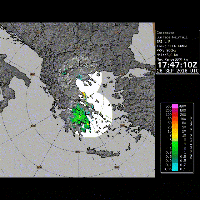
Aric Dunn wrote:Assuming no actual weather radar in Greece ? cant find anything except fake future cast crap .
http://www.emy.gr/emy/en/observation/eikones_radar
Only one and it's a still image
1 likes
Dolphins Marlins Canes Golden Panthers HEAT
Andrew 1992 - Irene 1999 - Frances 2004 - Jeanne 2004 - Wilma 2005 - Fay 2008 - Isaac 2012 - Matthew 2016 - Irma 2017 - Dorian 2019 - Ian 2022 - Nicole 2022
Andrew 1992 - Irene 1999 - Frances 2004 - Jeanne 2004 - Wilma 2005 - Fay 2008 - Isaac 2012 - Matthew 2016 - Irma 2017 - Dorian 2019 - Ian 2022 - Nicole 2022
-
Aric Dunn
- Category 5
- Posts: 21228
- Age: 41
- Joined: Sun Sep 19, 2004 9:58 pm
- Location: Ready for the Chase.
- Contact:
Re: MED: ZORBAS - Tropical Storm over the Mediterranean Sea
AdamFirst wrote:Aric Dunn wrote:Assuming no actual weather radar in Greece ? cant find anything except fake future cast crap .
http://www.emy.gr/emy/en/observation/eikones_radar
Only one and it's a still image
well thats a blast from the past.. I suppose most of europe has no need for hi res radar data..
1 likes
Note: If I make a post that is brief. Please refer back to previous posts for the analysis or reasoning. I do not re-write/qoute what my initial post said each time.
If there is nothing before... then just ask
Space & Atmospheric Physicist, Embry-Riddle Aeronautical University,
I believe the sky is falling...
If there is nothing before... then just ask
Space & Atmospheric Physicist, Embry-Riddle Aeronautical University,
I believe the sky is falling...
-
mrbagyo

- Category 5
- Posts: 3614
- Age: 31
- Joined: Thu Apr 12, 2012 9:18 am
- Location: 14.13N 120.98E
- Contact:
Re: MED: ZORBAS - Tropical Storm over the Mediterranean Sea
Thanks for that radar link, I was able to loop it (image are not that good though)
1 likes
The posts in this forum are NOT official forecast and should not be used as such. They are just the opinion of the poster and may or may not be backed by sound meteorological data. They are NOT endorsed by any professional institution or storm2k.org. For official information, please refer to RSMC, NHC and NWS products.
-
Vince_and_Grace_fan

- Category 1
- Posts: 315
- Joined: Thu Nov 03, 2016 9:25 am
- Location: Szombathely (Hungary)
Re: MED: ZORBAS - Hurricane over the Mediterranean Sea
It looks pretty good now. If it would have been more time over water...

1 likes
-
Vince_and_Grace_fan
- Category 1
- Posts: 315
- Joined: Thu Nov 03, 2016 9:25 am
- Location: Szombathely (Hungary)
Re: MED: ZORBAS - Hurricane over the Mediterranean Sea
The eye is over Kalamata now. The pressure dropped to 989 hPa and the highest 10-min sustained wind was near 65 km/h (35 kt). The strongest gust was 98 km/h (53 kt). An ASCAT pass at 08:52 UTC showed 50-55 kt winds on the western side of the cyclone and a ship also reported 50 kt wind there at 05 UTC.
http://penteli.meteo.gr/stations/kalamatawest/

http://penteli.meteo.gr/stations/kalamatawest/
3 likes
Re: MED: ZORBAS - Hurricane over the Mediterranean Sea
Aric Dunn wrote:AdamFirst wrote:Aric Dunn wrote:Assuming no actual weather radar in Greece ? cant find anything except fake future cast crap .
http://www.emy.gr/emy/en/observation/eikones_radar
Only one and it's a still image
well thats a blast from the past.. I suppose most of europe has no need for hi res radar data..
In Belgium we have high res radar and not really extreme weather. Maybe it's more of a financial thing than anything else.
2 likes

Re: MED: ZORBAS - Hurricane over the Mediterranean Sea
ESTOFEX estimates this to have 65 kt winds and a central pressure of 987 mb. Dvorak numbers are apparently at T4.0:
Source: http://www.estofex.org/
Mesoscale Discussion
Valid: Sat 29 Sep 2018 12:00 to Sat 29 Sep 2018 21:00 UTC
Issued: Sat 29 Sep 2018 12:29
Forecaster: ESTOFEX
This is an intermediate bulletin regarding Mediterranean cyclone 2018M02 because of intensification of the system.
System: 2018M02
At 29 SEP 1200UTC the storm centre was located near 37.0 N and 22.3 E
Estimated minimum pressure: 987 mb.
Maximum sustained winds: 33 m/s (65 kt, 120 km/h).
Maximum gusts: 40 m/s (80 kt, 140 km/h).
Since 06 UTC, the cyclone has further intensified as it made landfall in the southern Peloponnese. The centre has since then temporarily moved over water again. A brief eye covered by thin cirrus has become visible in VIS imagery since 9 UTC. The intensity estimate now suggests a Dvorak T4.0 number of 4.0 and a central pressure of 987 mb, as well as marginal hurricane wind speed of 33 m/s (65 kt). At 12 UTC Kalamata, a little north of the centre, reported a pressure of 989 mb, which corroborates this intensity estimate.
Near hurricane-force winds are affecting the far southern Peleponnese and the Cyclades. Torrential rainfall is expected to be the most important hazard though.
Severe flash floods with possible landslides are possible, particular in Southeastern Peloponnese, Attica, Euboia, and Eastern Thessaly where 100-300 mm storm totals are expected. These amounts are forecast for other regions:
Central and Eastern Makedonia: 80-160 mm
Western and Central Peloponnese, Central Greece, Southern and Western Crete, Turkish coastal regions from Kash until Canakkale: 30-100 mm
Cyclades: 30-60 mm
Additionally, storm surge of 1 to 1.5 m are likely on the Peloponnese coast.
Finally, there is a risk of tornadoes in the northeast quadrant of the cyclone, where long curved low-level hodographs are present, primarily affecting southern Peloponnese and Attica. For more details, refer to the convective forecast.
The next full MD will appear tonight at 21 UTC.
Source: http://www.estofex.org/
2 likes


Re: MED: ZORBAS - Hurricane over the Mediterranean Sea
Are MED storms no longer designated by NOAA?
0 likes
-
Hurricanehink

- S2K Supporter
- Posts: 2022
- Joined: Sun Nov 16, 2003 2:05 pm
- Location: New Jersey
Re: MED: ZORBAS - Hurricane over the Mediterranean Sea
Does anyone know who named the storm "Zorba/Zorbas"?
0 likes
-
Aric Dunn
- Category 5
- Posts: 21228
- Age: 41
- Joined: Sun Sep 19, 2004 9:58 pm
- Location: Ready for the Chase.
- Contact:
Re: MED: ZORBAS - Hurricane over the Mediterranean Sea
That sure looks like a shallow convective hurricane to me..
1 likes
Note: If I make a post that is brief. Please refer back to previous posts for the analysis or reasoning. I do not re-write/qoute what my initial post said each time.
If there is nothing before... then just ask
Space & Atmospheric Physicist, Embry-Riddle Aeronautical University,
I believe the sky is falling...
If there is nothing before... then just ask
Space & Atmospheric Physicist, Embry-Riddle Aeronautical University,
I believe the sky is falling...
-
ozonepete
- Professional-Met

- Posts: 4743
- Joined: Mon Sep 07, 2009 3:23 pm
- Location: From Ozone Park, NYC / Now in Brooklyn, NY
Re: MED: ZORBAS - Hurricane over the Mediterranean Sea
Has to be a hurricane. And made two landfalls. First on the peninsula just south of Pilos then on the mainland just south of Kalamata.

3 likes
-
Vince_and_Grace_fan
- Category 1
- Posts: 315
- Joined: Thu Nov 03, 2016 9:25 am
- Location: Szombathely (Hungary)
Re: MED: ZORBAS - Hurricane over the Mediterranean Sea
Aric Dunn wrote:That sure looks like a shallow convective hurricane to me..
The convection wasn't shallow, the cyclone produced cloud tops around -55, -60 °C permanently before and at the landfall. But the available data didn't support hurricane intensity. As I have mentioned earlier, an ASCAT pass near 09 UTC showed 50 kt wind, and the highest measured 10-min sustained wind in Greece was 80 km/h (43 kt) in Pylos (west coast of the Peloppenese, SW from Kalamata). However, that station reported hurricane-force 121 km/h gust.I think the peak intensity was at most 60 kt with 987 hPa cenrtral pressure.
http://penteli.meteo.gr/stations/pylos/
Hurricanehink: I think the names came from the media, as Trixie in 2016.
Today's animation (beside the nice structure it had well-defined upper level outflow too):

3 likes
-
ozonepete
- Professional-Met
- Posts: 4743
- Joined: Mon Sep 07, 2009 3:23 pm
- Location: From Ozone Park, NYC / Now in Brooklyn, NY
Re: MED: ZORBAS - Hurricane over the Mediterranean Sea
Vince_and_Grace_fan wrote:Aric Dunn wrote:That sure looks like a shallow convective hurricane to me..
The convection wasn't shallow, the cyclone produced cloud tops around -55, -60 °C permanently before and at the landfall. But the available data didn't support hurricane intensity. As I have mentioned earlier, an ASCAT pass near 09 UTC showed 50 kt wind, and the highest measured 10-min sustained wind in Greece was 80 km/h (43 kt) in Pylos (west coast of the Peloppenese, SW from Kalamata). However, that station reported hurricane-force 121 km/h gust.I think the peak intensity was at most 60 kt with 987 hPa cenrtral pressure.
url]http://penteli.meteo.gr/stations/pylos/
Hurricanehink: I think the names came from the media, as Trixie in 2016.
Today's animation (beside the nice structure it had well-defined upper level outflow too):
http://gallery.site.hu/d/28661424-1/Med_20180929.gif
Thanks for the great gif! Yeah I'm still thinking it made 65 knots somewhere offshore just before landfall with such a strong, symmetric core.
2 likes
-
Vince_and_Grace_fan
- Category 1
- Posts: 315
- Joined: Thu Nov 03, 2016 9:25 am
- Location: Szombathely (Hungary)
Re: ZORBAS - Hurricane over the Mediterranean Sea
Thanks for the great gif! Yeah I'm still thinking it made 65 knots somewhere offshore just before landfall with such a strong, symmetric core.
Yes, this is not impossible, but we will never know. We need Recon.
Also, I will look through the amateur meteorological stations too in the next days.
1 likes
Who is online
Users browsing this forum: No registered users and 97 guests