BOB : GAJA - Depression

Moderator: S2k Moderators

Message
Author
User avatar
mrbagyo
Category 5
Category 5
Posts: 3613
Age: 31
Joined: Thu Apr 12, 2012 9:18 am
Location: 14.13N 120.98E
Contact:

BOB : GAJA - Depression

#1 Postby mrbagyo » Tue Nov 06, 2018 9:04 pm

90W INVEST 181107 0000 8.0N 102.7E WPAC 15 1010

Image

From TMD
Weather Warning
"Heavy Rain in South"
No. 2 Time Issued : November 7, 2018
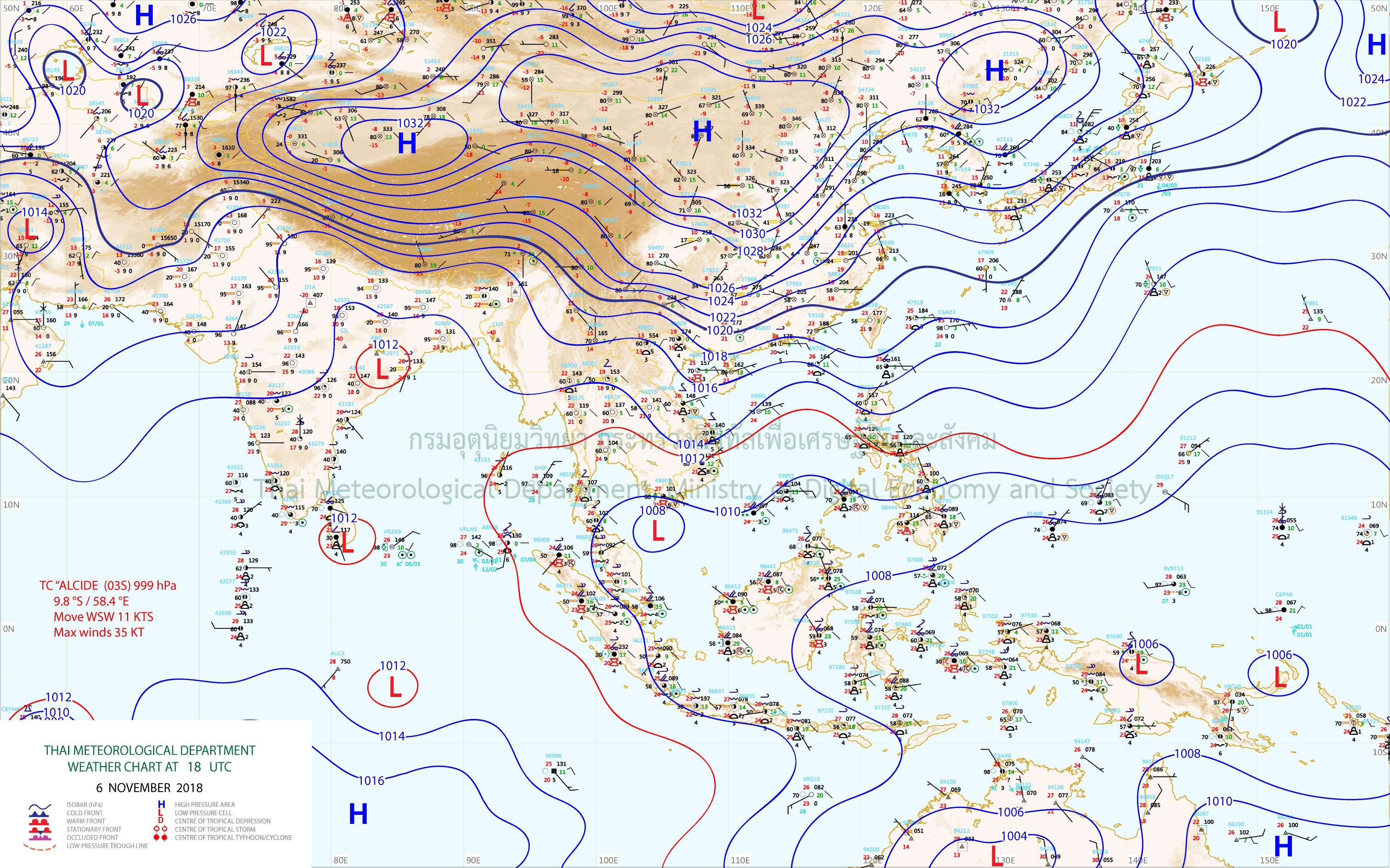
The low-pressure cell over the middle Gulf of Thailand is expected to move through the South to the Andaman Sea from 7-10 November. The threat of rains will affect the South as followings:

7-8 November: Isolated torrential rains over provinces of Prachuap Khiri Khan, Chumphon, Surat Thani, Nakhon Si Thammarat, Phatthalung, Songkhla, Ranong, Phang Nga, Phuket, Krabi, Trang and Satun.

9-10 November: Isolated heavy rains over provinces of Phetchaburi, Prachuap Khiri Khan, Chumphon, Surat Thani, Nakhon Si Thammarat, Ranong, Phang Nga, Phuket, Krabi, Trang and Satun.

All people in risky areas are advised to brace for a possible flash flood and the overflow of water. The wind-waves in the Gulf are forecast about 2 meters high and more than 2 meters high in thundershower areas. Small boats should keep.
Last edited by mrbagyo on Sun Nov 11, 2018 7:33 am, edited 2 times in total.
0 likes   
The posts in this forum are NOT official forecast and should not be used as such. They are just the opinion of the poster and may or may not be backed by sound meteorological data. They are NOT endorsed by any professional institution or storm2k.org. For official information, please refer to RSMC, NHC and NWS products.

User avatar
mrbagyo
Category 5
Category 5
Posts: 3613
Age: 31
Joined: Thu Apr 12, 2012 9:18 am
Location: 14.13N 120.98E
Contact:

Re: WPAC : INVEST 90W

#2 Postby mrbagyo » Tue Nov 06, 2018 9:14 pm

Radar loop ©TMD
Image

Visible loop
Image
0 likes   
The posts in this forum are NOT official forecast and should not be used as such. They are just the opinion of the poster and may or may not be backed by sound meteorological data. They are NOT endorsed by any professional institution or storm2k.org. For official information, please refer to RSMC, NHC and NWS products.

Grifforzer
Category 1
Category 1
Posts: 418
Joined: Thu Feb 26, 2009 11:27 pm

Re: WPAC : INVEST 90W

#3 Postby Grifforzer » Wed Nov 07, 2018 9:08 am

Wednesday 07 November 2018
Time of Issue: 1630 Hours IST
Based on 1430 hours IST Observations
All India Weather Inference (EVENING)

A cyclonic circulation over South China Sea & adjoining Gulf of Thailand extending up to 3.1 km above mean sea level persists. It is likely to emerge into the Andaman Sea and under its influence a Low Pressure Area is likely to develop over Andaman Sea & adjoining southeastern Bay of Bengal during next 48 hours. The Low Pressure Area is likely to move west­ northwestwards and intensify further.

-------
Updated (08NOV)

Thursday 08 November 2018
Time of Issue: 1930 Hours IST
Based on 1730 hours IST Observations
All India Weather Inference (NIGHT)

The low pressure area over Gulf of Thailand and adjoining Malay peninsula persists. Associated cyclonic circulation extends up to mid­-tropospheric level persists. It is very likely to emerge into the Andaman Sea become more marked during the next 24 hours. It is likely to move west northwestward and concentrate into a depression during the subsequent 24 hours.

-------
Updated (09NOV)

Friday 09 November 2018
Time of Issue: 2030 Hours IST
Based on 1730 hours IST Observations
All India Weather Inference (NIGHT)

A well marked low pressure area over north Andaman Sea and neighborhood. It is very likely to move west­ northwestwards, concentrate into a depression during next 24 hours and into a cyclonic storm during the subsequent 24 hours.
0 likes   

User avatar
doomhaMwx
Category 5
Category 5
Posts: 2396
Age: 25
Joined: Tue Apr 18, 2017 4:01 am
Location: Baguio/Benguet, Philippines
Contact:

Re: BOB: 90W - Depression

#4 Postby doomhaMwx » Sat Nov 10, 2018 3:02 am

90W INVEST 181110 0600 12.2N 91.2E WPAC 25 1007

Image
Image
Last edited by doomhaMwx on Sat Nov 10, 2018 3:14 am, edited 1 time in total.
0 likes   
Like my content? Consider giving a tip.

User avatar
doomhaMwx
Category 5
Category 5
Posts: 2396
Age: 25
Joined: Tue Apr 18, 2017 4:01 am
Location: Baguio/Benguet, Philippines
Contact:

Re: BOB : 90W - Depression

#5 Postby doomhaMwx » Sat Nov 10, 2018 3:07 am

Now a depression by the IMD.
Sub: Depression over southeast Bay of Bengal
Latest satellite imageries and surface observations indicate that a depression has formed
over southeast Bay of Bengal and lay centred at 0830 hrs IST of today, the 10
th November, 2018
near latitude 11.7°N and longitude 92.5°E, about 20 km northwest of Port Blair (Andaman Islands),
1340 km east-southeast of Chennai (Tamil Nadu) and 1390 km east-southeast of Nellore (Andhra
Pradesh). It is very likely to intensify into a Deep Depression during next 24 hours and into a
Cyclonic Storm during the subsequent 24 hours. It is very likely to move west-northwestwards during
next 48 hours and then west-southwestwards towards north Tamil Nadu – south Andhra Pradesh
coasts during the subsequent 72 hours.

Image
0 likes   
Like my content? Consider giving a tip.

User avatar
TorSkk
Category 2
Category 2
Posts: 514
Joined: Thu Jul 05, 2018 5:08 am

BOB: Gaja - Deep Depression

#6 Postby TorSkk » Sat Nov 10, 2018 3:51 pm

07B SEVEN 181110 1800 13.1N 89.4E IO 35 1000

THE DEEP DEPRESSION OVER SOUTHEAST & ADJOINING CENTRAL BAY OF
BENGAL MOVED WEST-NORTHWESTWARDS WITH A SPEED OF 18 KMPH DURING PAST
06 HOURS AND LAY CENTRED AT 1800 UTC OF TODAY, THE 10TH NOVEMBER, 2018 NEAR
LATITUDE 13.0°N AND LONGITUDE 89.9°E ABOUT 330 KM WEST-NORTHWEST OF PORT
BLAIR (ANDAMAN ISLANDS) (43333), 1055 KM EAST OF CHENNAI(43278) (TAMIL NADU)
AND 1120 KM EAST-SOUTHEAST OF NELLORE (43245) (ANDHRA PRADESH). IT IS VERY
LIKELY TO INTENSIFY INTO A CYCLONIC STORM DURING NEXT 12 HOURS. IT IS VERY
LIKELY TO MOVE WEST-NORTHWESTWARDS DURING NEXT 36 HOURS AND THEN WESTSOUTHWESTWARDS
TOWARDS NORTH TAMIL NADU – SOUTH ANDHRA PRADESH
COASTS DURING THE SUBSEQUENT 72 HOURS.


The next name on the list is Gaja
Last edited by TorSkk on Sun Nov 11, 2018 2:49 am, edited 1 time in total.
1 likes   

User avatar
Nancy Smar
Category 5
Category 5
Posts: 1081
Age: 23
Joined: Wed Aug 16, 2017 10:03 pm

Re: BOB: Gaja - Deep Depression

#7 Postby Nancy Smar » Sat Nov 10, 2018 10:33 pm

FKIN20 DEMS 110315
TC ADVISORY
TCAC: NEW DELHI
DTG: 20181111/0000Z
TC: GAJA
NR: 3
PSN: N1324 E08918
MOV: WNW05KT
C: 1002HPA
MAX WIND: 35KT
FCST PSN+06HR: 11/0600Z N1336 E08842
FCST MAX WIND+06HR: 40KT
FCST PSN+12HR: 11/1200Z N1348 E08812
FCST MAX WIND+12HR: 40KT
FCST PSN+18HR: 11/1800Z N1400 E08742
FCST MAX WIND+18HR: 45KT
FCST PSN+24HR: 12/0000Z N1412 E08718
FCST MAX WIND+24HR: 45KT
RMK: NIL
NXT MSG: 20181111/0900Z
TOO: 110836 HRS IST
0 likes   

User avatar
doomhaMwx
Category 5
Category 5
Posts: 2396
Age: 25
Joined: Tue Apr 18, 2017 4:01 am
Location: Baguio/Benguet, Philippines
Contact:

Re: BOB: GAJA - Cyclonic Storm

#8 Postby doomhaMwx » Sun Nov 11, 2018 5:42 am

Now numbered 07B by JTWC and named "Gaja" by IMD.

Image
0 likes   
Like my content? Consider giving a tip.

User avatar
doomhaMwx
Category 5
Category 5
Posts: 2396
Age: 25
Joined: Tue Apr 18, 2017 4:01 am
Location: Baguio/Benguet, Philippines
Contact:

Re: BOB : GAJA - Cyclonic Storm

#9 Postby doomhaMwx » Sun Nov 11, 2018 10:53 pm

Image
Image
0 likes   
Like my content? Consider giving a tip.

User avatar
galaxy401
Category 5
Category 5
Posts: 2297
Age: 28
Joined: Sat Aug 25, 2012 9:04 pm
Location: Casa Grande, Arizona

Re: BOB : GAJA - Cyclonic Storm

#10 Postby galaxy401 » Mon Nov 12, 2018 1:39 am

Why is this storm still in the WPAC board?
0 likes   
Got my eyes on moving right into Hurricane Alley: Florida.

User avatar
mrbagyo
Category 5
Category 5
Posts: 3613
Age: 31
Joined: Thu Apr 12, 2012 9:18 am
Location: 14.13N 120.98E
Contact:

Re: BOB : GAJA - Cyclonic Storm

#11 Postby mrbagyo » Wed Nov 14, 2018 9:16 pm

Midget cyclone
Image

Image

I can see a hint of an eye forming but somebody authorized should move this thread to Indian Ocean
0 likes   
The posts in this forum are NOT official forecast and should not be used as such. They are just the opinion of the poster and may or may not be backed by sound meteorological data. They are NOT endorsed by any professional institution or storm2k.org. For official information, please refer to RSMC, NHC and NWS products.

User avatar
galaxy401
Category 5
Category 5
Posts: 2297
Age: 28
Joined: Sat Aug 25, 2012 9:04 pm
Location: Casa Grande, Arizona

Re: BOB: Gaja - Cyclonic Storm

#12 Postby galaxy401 » Thu Nov 15, 2018 2:23 am

Gaja is about to make landfall over southern India soon. Now at 55 knots. Not sure how this system will do once it reemerges in the Arabian Sea.

(BTW, can we merge this topic with the one that is still in the WPAC board. This storm isn't dead)
0 likes   
Got my eyes on moving right into Hurricane Alley: Florida.

User avatar
WAcyclone
Category 1
Category 1
Posts: 349
Joined: Sat Jul 01, 2017 1:56 pm
Location: Perth, Western Australia

Re: BOB: Gaja - Cyclonic Storm

#13 Postby WAcyclone » Thu Nov 15, 2018 6:29 am

Gaja now has an almost complete eyewall:

Image
0 likes   

User avatar
wxman57
Moderator-Pro Met
Moderator-Pro Met
Posts: 22472
Age: 66
Joined: Sat Jun 21, 2003 8:06 pm
Location: Houston, TX (southwest)

Re: BOB: Gaja - Severe Cyclonic Storm

#14 Postby wxman57 » Thu Nov 15, 2018 8:10 am

Eye now visible, yet IMD says 45-50 kts for its intensity...
0 likes   

User avatar
WAcyclone
Category 1
Category 1
Posts: 349
Joined: Sat Jul 01, 2017 1:56 pm
Location: Perth, Western Australia

Re: BOB: Gaja - Severe Cyclonic Storm

#15 Postby WAcyclone » Thu Nov 15, 2018 9:25 am

This is a serious situation for the very low-lying district of Nagapattinam.

Image

Karaikal radar:

Image

Radar velocities are at least 90 kt in the northern eyewall:

Image

Source: http://www.imd.gov.in/pages/radar_main.php?adta=kkl
0 likes   

User avatar
doomhaMwx
Category 5
Category 5
Posts: 2396
Age: 25
Joined: Tue Apr 18, 2017 4:01 am
Location: Baguio/Benguet, Philippines
Contact:

Re: BOB: Gaja - Severe Cyclonic Storm

#16 Postby doomhaMwx » Thu Nov 15, 2018 9:27 am

JTWC and IMD severely underestimating this storm! (55kts @ 12Z)
1248Z SATCON estimate is 93kts. CIMSS ADT has a final T# of 4.5 @ 1345Z.

Image
Image

CIMSS TROPICAL CYCLONE INTENSITY CONSENSUS FOR 07B (07B) 2018
CURRENT ESTIMATE
Date (mmddhhmm): 11151248
SATCON: MSLP = 966 hPa MSW = 93 knots
SATCON Member Consensus: 92.0 knots
Pressure -> Wind Using SATCON MSLP: 91 knots
Distance to Outer Closed Isobar Used is 160 nm
Eye Size Correction Used is 0 knots Source: MW

Member Estimates

ADT: 981 hPa 77 knots Scene: CDO Date: NOV151315
CIMSS AMSU: 943 hPa 120 knots Bias Corr: 0 (MW) Date: 11151112
ATMS: 983.6 hPa 68.1 knots Date: 11150808
SSMIS: 974.0 hPa 84.0 knots Date: 11151248
CIRA ATMS: 1011 hPa 21 knots Date:

----- Current Analysis -----
Date : 15 NOV 2018 Time : 134500 UTC
Lat : 10:50:24 N Lon : 80:54:00 E


CI# /Pressure/ Vmax
4.5 / 980.7mb/ 77.0kt


Final T# Adj T# Raw T#
4.5 4.5 3.5
0 likes   
Like my content? Consider giving a tip.

User avatar
doomhaMwx
Category 5
Category 5
Posts: 2396
Age: 25
Joined: Tue Apr 18, 2017 4:01 am
Location: Baguio/Benguet, Philippines
Contact:

Re: BOB: Gaja - Severe Cyclonic Storm

#17 Postby doomhaMwx » Thu Nov 15, 2018 10:13 am

CIMSS ADT and SATCON estimates are ranging from 75-95kts.
0 likes   
Like my content? Consider giving a tip.

User avatar
mrbagyo
Category 5
Category 5
Posts: 3613
Age: 31
Joined: Thu Apr 12, 2012 9:18 am
Location: 14.13N 120.98E
Contact:

Re: BOB: Gaja - Severe Cyclonic Storm

#18 Postby mrbagyo » Thu Nov 15, 2018 10:26 am

This just gone bonkers - not surprised though given its compact /small sized nature
0 likes   
The posts in this forum are NOT official forecast and should not be used as such. They are just the opinion of the poster and may or may not be backed by sound meteorological data. They are NOT endorsed by any professional institution or storm2k.org. For official information, please refer to RSMC, NHC and NWS products.

User avatar
WAcyclone
Category 1
Category 1
Posts: 349
Joined: Sat Jul 01, 2017 1:56 pm
Location: Perth, Western Australia

Re: BOB: Gaja - Severe Cyclonic Storm

#19 Postby WAcyclone » Thu Nov 15, 2018 2:55 pm

Gaja is about to make landfall between Nagapattinam and Vedaranyam. There's a weather station in Nagapattinam (well outside of the eyewall) currently reporting sustained winds of 30 kt gusting to 45 kt and a pressure of 994 mb.

Image

Source: http://www.imd.gov.in/pages/radar_main.php?adta=kkl
0 likes   

User avatar
wxman57
Moderator-Pro Met
Moderator-Pro Met
Posts: 22472
Age: 66
Joined: Sat Jun 21, 2003 8:06 pm
Location: Houston, TX (southwest)

Re: BOB: Gaja - Severe Cyclonic Storm

#20 Postby wxman57 » Thu Nov 15, 2018 3:18 pm

IMD is now saying 55 kts for the intensity.
0 likes   


Return to “2018”

Who is online

Users browsing this forum: No registered users and 16 guests