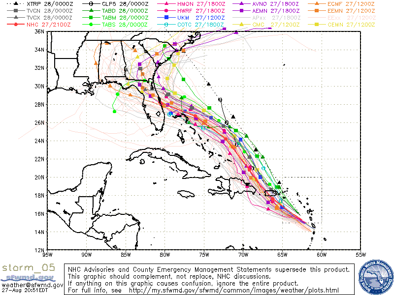
ATL: DORIAN - Models

Moderator: S2k Moderators

Message
Author
Aric Dunn
Category 5
Category 5
Posts: 21238
Age: 42
Joined: Sun Sep 19, 2004 9:58 pm
Location: Ready for the Chase.
Contact:

Re: ATL: DORIAN - Models

#1121 Postby Aric Dunn » Tue Aug 27, 2019 8:03 pm

toad strangler wrote:
gatorcane wrote:TVCN yet again north of NHC. Trend has been north with the models all day, will it continue?

https://i.postimg.cc/RVRGf11D/storm-05-ens.gif


We’ve seen it before!


and we have seen them go against the model consensus. as they did with Dorian already multiple times...sooo
0 likes   
Note: If I make a post that is brief. Please refer back to previous posts for the analysis or reasoning. I do not re-write/qoute what my initial post said each time.
If there is nothing before... then just ask :)

Space & Atmospheric Physicist, Embry-Riddle Aeronautical University,
I believe the sky is falling...

User avatar
gatorcane
S2K Supporter
S2K Supporter
Posts: 23691
Age: 47
Joined: Sun Mar 13, 2005 3:54 pm
Location: Boca Raton, FL

Re: ATL: DORIAN - Models

#1122 Postby gatorcane » Tue Aug 27, 2019 8:04 pm

otowntiger wrote:It seems as if a recurve or at least curve well north of Florida is now on the table looking at several models such as GFS, legacy GFS, JMA, to name a few.


Add the NAVGEM too. Definitely recurve just offshore US seems on the table suddenly. Chances look small but the chances have certainly increased some.
Last edited by gatorcane on Tue Aug 27, 2019 8:06 pm, edited 1 time in total.
0 likes   

hohnywx
Category 2
Category 2
Posts: 508
Age: 34
Joined: Sun Jul 19, 2009 8:34 pm
Location: Hastings-on-Hudson, NY

Re: ATL: DORIAN - Models

#1123 Postby hohnywx » Tue Aug 27, 2019 8:05 pm

gatorcane wrote:TVCN yet again north of NHC. Trend has been north with the models all day, will it continue?

https://i.postimg.cc/RVRGf11D/storm-05-ens.gif


The BAMs seem to be the only ones initializing from the correct location on that plot.
0 likes   

tgenius
S2K Supporter
S2K Supporter
Posts: 1160
Joined: Mon May 15, 2006 5:31 pm
Location: Miami, FL

Re: ATL: DORIAN - Models

#1124 Postby tgenius » Tue Aug 27, 2019 8:06 pm

gatorcane wrote:
otowntiger wrote:It seems as if a recurve or at least curve well north of Florida is now on the table looking at several models such as GFS, legacy GFS, JMA, to name a few.


Add the NAVGEM too. Definitely recurve just offshore US seems on the table suddenly.


Models didn’t initialize correctly. Take them with grain of salt.
1 likes   

invest man
Tropical Storm
Tropical Storm
Posts: 206
Joined: Sun Aug 17, 2008 8:12 pm

Re: ATL: DORIAN - Models

#1125 Postby invest man » Tue Aug 27, 2019 8:11 pm

Emmett_Brown wrote:The majority of 18z GFS ensemble members continue to hit the east coast of FL. The a few stronger ones turn N before the FL coast: https://www.weathernerds.org/tc_guidanc ... ?tcid=AL05


Just curious. Why does those models turn it up and curve kinda of like Floyd 1999? Are they responding to an approaching cold front or the periphery of the Bermuda High. Not suggesting that those scenarios will pan out but what are those ensembles seeing? Anybody have a reason? IM
0 likes   

stormlover2013

Re: ATL: DORIAN - Models

#1126 Postby stormlover2013 » Tue Aug 27, 2019 8:11 pm

Jma has been bad all year with systems, navy is absolute horrible, gfs has been up and down like no other, till euro, ukmet, icon go on there side then we can start talking
1 likes   

User avatar
HDGator
S2K Supporter
S2K Supporter
Posts: 242
Joined: Fri Sep 17, 2004 3:03 pm
Location: Lewisville, NC

Re: ATL: DORIAN - Models

#1127 Postby HDGator » Tue Aug 27, 2019 8:11 pm

gatorcane wrote:TVCN yet again north of NHC. Trend has been north with the models all day, will it continue?

https://i.postimg.cc/RVRGf11D/storm-05-ens.gif

It's always the same story. How good of a handle do the models have on a building ridge 4-5 days out?
Their track record doesn't give me much faith. It's down to wait and see when we have better data.
0 likes   
Personal Forecast Disclaimer:
The posts in this forum are NOT official forecast and should not be used as such. They are just the opinion of the poster and may or may not be backed by sound meteorological data. They are NOT endorsed by any professional institution or storm2k.org. For official information, please refer to the NHC and NWS products.

User avatar
Hammy
Category 5
Category 5
Posts: 5849
Age: 42
Joined: Fri May 25, 2012 5:25 pm
Contact:

Re: ATL: DORIAN - Models

#1128 Postby Hammy » Tue Aug 27, 2019 8:12 pm

tgenius wrote:
gatorcane wrote:
otowntiger wrote:It seems as if a recurve or at least curve well north of Florida is now on the table looking at several models such as GFS, legacy GFS, JMA, to name a few.


Add the NAVGEM too. Definitely recurve just offshore US seems on the table suddenly.


Models didn’t initialize correctly. Take them with grain of salt.


Seems like nobody's getting much sleep tonight if they want decent runs :lol:
0 likes   
The above post is not official and should not be used as such. It is the opinion of the poster and may or may not be backed by sound meteorological data. It is not endorsed by any professional institution or storm2k.org. For official information, please refer to the NHC and NWS products.

AutoPenalti
Category 5
Category 5
Posts: 4030
Age: 29
Joined: Mon Aug 17, 2015 4:16 pm
Location: Ft. Lauderdale, Florida

Re: ATL: DORIAN - Models

#1129 Postby AutoPenalti » Tue Aug 27, 2019 8:14 pm

Any model that was initialized at 18z is pretty much for satire at this point.
1 likes   
The posts in this forum are NOT official forecasts and should not be used as such. They are just the opinion of the poster and may or may not be backed by sound meteorological data. They are NOT endorsed by any professional institution or STORM2K. For official information, please refer to products from the NHC and NWS.


Model Runs Cheat Sheet:
GFS (5:30 AM/PM, 11:30 AM/PM)
HWRF, GFDL, UKMET, NAVGEM (6:30-8:00 AM/PM, 12:30-2:00 AM/PM)
ECMWF (1:45 AM/PM)

TCVN
is a weighted averaged

TheStormExpert

Re: ATL: DORIAN - Models

#1130 Postby TheStormExpert » Tue Aug 27, 2019 8:15 pm

Give Florida Something is apparently at it again with it’s old tricks! We’ll luck out big time if this ends of going OTS!
1 likes   

User avatar
Blown Away
S2K Supporter
S2K Supporter
Posts: 10147
Joined: Wed May 26, 2004 6:17 am

Re: ATL: DORIAN - Models

#1131 Postby Blown Away » Tue Aug 27, 2019 8:16 pm

Image
18Z GFS ensembles... Not clear cut...
0 likes   
Hurricane Eye Experience: David 79, Irene 99, Frances 04, Jeanne 04, Wilma 05... EYE COMING MY WAY IN 2024…
Hurricane Brush Experience: Andrew 92, Erin 95, Floyd 99, Matthew 16, Irma 17, Ian 22, Nicole 22…

User avatar
ronjon
Category 5
Category 5
Posts: 4822
Joined: Fri Aug 19, 2005 5:17 pm
Location: Hernando Beach, FL

Re: ATL: DORIAN - Models

#1132 Postby ronjon » Tue Aug 27, 2019 8:22 pm

alienstorm wrote:The 18z EURO shows a stout High that turns Dorian westward at 90 hrs it shows Dorian west of Abaco heading west toward South Florida.


Euro definitely faster than GFS and other models taking the system to the east coast. Not sure if its differences in speed or ridge strength driving the different solutions. Euro just gets to the east coast 24 hrs sooner and thus the ridging is stronger.
0 likes   

User avatar
toad strangler
S2K Supporter
S2K Supporter
Posts: 4543
Joined: Sun Jul 28, 2013 3:09 pm
Location: Earth
Contact:

Re: ATL: DORIAN - Models

#1133 Postby toad strangler » Tue Aug 27, 2019 8:25 pm

WATCH LEVI’S VIDEO to really gain knowledge on the key players at hand

 https://twitter.com/tropicaltidbits/status/1166512400004190208


4 likes   

Bhuggs
Tropical Depression
Tropical Depression
Posts: 56
Joined: Wed Aug 24, 2016 9:22 pm

Re: ATL: DORIAN - Models

#1134 Postby Bhuggs » Tue Aug 27, 2019 8:25 pm

Does the wrong initialization have an effect on the ridge and overall steering pattern?
0 likes   

Aric Dunn
Category 5
Category 5
Posts: 21238
Age: 42
Joined: Sun Sep 19, 2004 9:58 pm
Location: Ready for the Chase.
Contact:

Re: ATL: DORIAN - Models

#1135 Postby Aric Dunn » Tue Aug 27, 2019 8:26 pm

ronjon wrote:
alienstorm wrote:The 18z EURO shows a stout High that turns Dorian westward at 90 hrs it shows Dorian west of Abaco heading west toward South Florida.


Euro definitely faster than GFS and other models taking the system to the east coast. Not sure if its differences in speed or ridge strength driving the different solutions. Euro just gets to the east coast 24 hrs sooner and thus the ridging is stronger.


well to the coast yeah.. the angle of approach is different and is farther south. so of course it reaches the coast sooner. check a longitude.
0 likes   
Note: If I make a post that is brief. Please refer back to previous posts for the analysis or reasoning. I do not re-write/qoute what my initial post said each time.
If there is nothing before... then just ask :)

Space & Atmospheric Physicist, Embry-Riddle Aeronautical University,
I believe the sky is falling...

User avatar
robbielyn
Category 5
Category 5
Posts: 1298
Joined: Wed May 07, 2003 9:45 am
Location: brooksville, fl

Re: ATL: DORIAN - Models

#1136 Postby robbielyn » Tue Aug 27, 2019 8:30 pm

Bhuggs wrote:Does the wrong initialization have an effect on the ridge and overall steering pattern?

according to levi no. what makes it east is an ull couple with mlc that separates from td #6 and dorian has to circumvent it but will be pulled back west. what will really influence track and landfall is how strong the ridge ends up being whether we get landfall in fl or up the coast or oos.
1 likes   
Robbielyn McCrary
I know just about enough to sound like I know what I'm talking about sometimes. But for your safety please follow the nhc for truly professional forecasting. :D

bamajammer4eva
Category 4
Category 4
Posts: 907
Joined: Sun Apr 18, 2010 3:21 am
Location: Ozark, AL

Re: ATL: DORIAN - Models

#1137 Postby bamajammer4eva » Tue Aug 27, 2019 8:32 pm

It seems that the GFS and Euro are in agreement of the overall track with the 18z GEFS members coming closer in line with the 12z EPS. Beyond 120 hrs is for entertainment only so here is the first 120 of 00z/12z EPS and 12z/18z GEFS to compare

Image
3 likes   

User avatar
ronjon
Category 5
Category 5
Posts: 4822
Joined: Fri Aug 19, 2005 5:17 pm
Location: Hernando Beach, FL

Re: ATL: DORIAN - Models

#1138 Postby ronjon » Tue Aug 27, 2019 8:55 pm

I think we've seen two big changes in the guidance today. 1) the system will be stronger with the possibility of a major hurricane approaching the east coast and 2) the 500 mb ridging may be weaker allowing Dorian to ride the coast perhaps out to sea. The 00z suite of runs will be interesting.
0 likes   

jeff
Professional-Met
Professional-Met
Posts: 831
Joined: Sun Sep 12, 2004 6:14 pm
Location: Houston, TX
Contact:

Re: ATL: DORIAN - Models

#1139 Postby jeff » Tue Aug 27, 2019 8:57 pm

Bhuggs wrote:Does the wrong initialization have an effect on the ridge and overall steering pattern?

No it does not
3 likes   

User avatar
Nimbus
Category 5
Category 5
Posts: 5303
Joined: Mon Jul 19, 2004 10:54 am

Re: ATL: DORIAN - Models

#1140 Postby Nimbus » Tue Aug 27, 2019 9:10 pm

toad strangler wrote:WATCH LEVI’S VIDEO to really gain knowledge on the key players at hand

https://twitter.com/tropicaltidbits/status/1166512400004190208


Recon found a lower surface pressure on the last pass so the core structure is likely to make it north of Puerto Rico where it will be traveling with the flow around the Upper level low.

Upper level lows will likely be in a position to ventilate Dorian later in the forecast.

I'm wondering if the weaker ridging scenario that is currently an outlier solution has any chance of validating or whether they are just trying to buy time for a more accurate landfall?


The models might see TD6 keeping a toe in the door so that the weakness is a little more persistent but that won't be enough to allow a recurve.
Last edited by Nimbus on Tue Aug 27, 2019 9:38 pm, edited 1 time in total.
0 likes   


Return to “2019”

Who is online

Users browsing this forum: No registered users and 13 guests