ATL: DORIAN - Models
Moderator: S2k Moderators
-
gatorcane

- S2K Supporter

- Posts: 23708
- Age: 48
- Joined: Sun Mar 13, 2005 3:54 pm
- Location: Boca Raton, FL
Re: ATL: DORIAN - Models
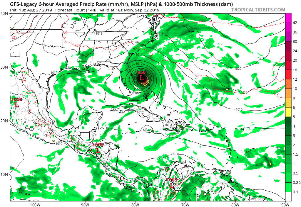
A few small shifts west and that GFS legacy run would be recurving through Southern Florida. That is 144 hours out so well within the error range for the model.
1 likes
-
Blown Away

- S2K Supporter
- Posts: 10253
- Joined: Wed May 26, 2004 6:17 am
Re: ATL: DORIAN - Models

18Z HWRF-P bombs out into Cat 4/5...
0 likes
Hurricane Eye Experience: David 79, Irene 99, Frances 04, Jeanne 04, Wilma 05… Hurricane Brush Experience: Andrew 92, Erin 95, Floyd 99, Matthew 16, Irma 17, Ian 22, Nicole 22…
-
SouthFloridawx

- S2K Supporter
- Posts: 8346
- Age: 47
- Joined: Tue Jul 26, 2005 1:16 am
- Location: Sarasota, FL
- Contact:


-
Blown Away
- S2K Supporter
- Posts: 10253
- Joined: Wed May 26, 2004 6:17 am
Re: ATL: DORIAN - Models

18z HWRF... Bonkers Cat/4/5
Last edited by Blown Away on Tue Aug 27, 2019 9:27 pm, edited 1 time in total.
0 likes
Hurricane Eye Experience: David 79, Irene 99, Frances 04, Jeanne 04, Wilma 05… Hurricane Brush Experience: Andrew 92, Erin 95, Floyd 99, Matthew 16, Irma 17, Ian 22, Nicole 22…

Re: ATL: DORIAN - Models
18z EPS Suite:


0 likes
Very useful information on the Dvorak Technique --
https://severe.worldweather.wmo.int/TCF ... kBeven.pdf
https://severe.worldweather.wmo.int/TCF ... kBeven.pdf

Re: ATL: DORIAN - Models
0z guidance does look like another north shift and more of an open door. Ridge watch time
0 likes
-
Bocadude85

- Category 5

- Posts: 2991
- Age: 39
- Joined: Mon Apr 18, 2005 2:20 pm
- Location: Honolulu,Hi
-
toad strangler

- S2K Supporter
- Posts: 4546
- Joined: Sun Jul 28, 2013 3:09 pm
- Location: Earth
- Contact:
Re: ATL: DORIAN - Models
Bocadude85 wrote:
A lot of clustering just off the S.Fla coast...
Which way are the moving lol
0 likes
My Weather Station
https://www.wunderground.com/dashboard/pws/KFLPORTS603
https://www.wunderground.com/dashboard/pws/KFLPORTS603
Re: ATL: DORIAN - Models
toad strangler wrote:Bocadude85 wrote:
A lot of clustering just off the S.Fla coast...
Which way are the moving lol
NW. A few showed signs of curving like the gfs at hour 144.
0 likes
Very useful information on the Dvorak Technique --
https://severe.worldweather.wmo.int/TCF ... kBeven.pdf
https://severe.worldweather.wmo.int/TCF ... kBeven.pdf
-
AutoPenalti
- Category 5
- Posts: 4091
- Age: 29
- Joined: Mon Aug 17, 2015 4:16 pm
- Location: Ft. Lauderdale, Florida
Re: ATL: DORIAN - Models
Bhuggs wrote:0z guidance does look like another north shift and more of an open door. Ridge watch time
Those are the ensembles...
0 likes
The posts in this forum are NOT official forecasts and should not be used as such. They are just the opinion of the poster and may or may not be backed by sound meteorological data. They are NOT endorsed by any professional institution or STORM2K. For official information, please refer to products from the NHC and NWS.
Model Runs Cheat Sheet:
GFS (5:30 AM/PM, 11:30 AM/PM)
HWRF, GFDL, UKMET, NAVGEM (6:30-8:00 AM/PM, 12:30-2:00 AM/PM)
ECMWF (1:45 AM/PM)
TCVN is a weighted averaged
Re: ATL: DORIAN - Models
EPS.GIF

4 likes
Very useful information on the Dvorak Technique --
https://severe.worldweather.wmo.int/TCF ... kBeven.pdf
https://severe.worldweather.wmo.int/TCF ... kBeven.pdf
-
SouthFloridawx
- S2K Supporter
- Posts: 8346
- Age: 47
- Joined: Tue Jul 26, 2005 1:16 am
- Location: Sarasota, FL
- Contact:
Re: ATL: DORIAN - Models
AutoPenalti wrote:Bhuggs wrote:0z guidance does look like another north shift and more of an open door. Ridge watch time
Those are the ensembles...
Yep, you are right. My bad.
0 likes

Re: ATL: DORIAN - Models
Mind boggling that there is so much difference between the GFS and Euro by 96-120 hours with the GFS showing a weaker ridge north of Dorian thus a more hook to the right while approaching FL on Saturday/Sunday. But this is where the Euro does the best in the 4-5 day range. We will see.
0 likes
-
Evil Jeremy

- S2K Supporter
- Posts: 5463
- Age: 32
- Joined: Mon Apr 10, 2006 2:10 pm
- Location: Los Angeles, CA
Re: ATL: DORIAN - Models
Those 18z EURO ensembles are evenly spread out from Miami through Jacksonville.
0 likes
Frances 04 / Jeanne 04 / Katrina 05 / Wilma 05 / Fay 08 / Debby 12 / Andrea 13 / Colin 16 / Hermine 16 / Matthew 16 / Irma 17
-
AxaltaRacing24
- Category 5
- Posts: 1774
- Age: 25
- Joined: Wed Jul 27, 2016 11:14 am
- Location: Jupiter, FL
Re: ATL: DORIAN - Models
Evil Jeremy wrote:Those 18z EURO ensembles are evenly spread out from Miami through Jacksonville.
A reminder that everything is still on the table. The trend can and will go either way.
1 likes
-
AutoPenalti
- Category 5
- Posts: 4091
- Age: 29
- Joined: Mon Aug 17, 2015 4:16 pm
- Location: Ft. Lauderdale, Florida
Re: ATL: DORIAN - Models
Really curious as to what 0z guidance will have.
Euro has a stronger ridge, known to sometimes overdo ridging. GFS has a slightly weaker ridge, know to underdo ridging.
UKMET has been doing okay so far.
Euro has a stronger ridge, known to sometimes overdo ridging. GFS has a slightly weaker ridge, know to underdo ridging.
UKMET has been doing okay so far.
0 likes
The posts in this forum are NOT official forecasts and should not be used as such. They are just the opinion of the poster and may or may not be backed by sound meteorological data. They are NOT endorsed by any professional institution or STORM2K. For official information, please refer to products from the NHC and NWS.
Model Runs Cheat Sheet:
GFS (5:30 AM/PM, 11:30 AM/PM)
HWRF, GFDL, UKMET, NAVGEM (6:30-8:00 AM/PM, 12:30-2:00 AM/PM)
ECMWF (1:45 AM/PM)
TCVN is a weighted averaged
-
tolakram
- Admin

- Posts: 20186
- Age: 62
- Joined: Sun Aug 27, 2006 8:23 pm
- Location: Florence, KY (name is Mark)
Re: ATL: DORIAN - Models
18z Euro has Dorian almost missing PR to the east at hour 24, then turning and moving due west between hour 75 and hour 90. Stronger and a little further north than the 12Z.
0 likes
M a r k
- - - - -
Join us in chat: Storm2K Chatroom Invite. Android and IOS apps also available.
The posts in this forum are NOT official forecasts and should not be used as such. Posts are NOT endorsed by any professional institution or STORM2K.org. For official information and forecasts, please refer to NHC and NWS products.
Re: ATL: DORIAN - Models
AutoPenalti wrote:Really curious as to what 0z guidance will have.
Euro has a stronger ridge, known to sometimes overdo ridging. GFS has a slightly weaker ridge, know to underdo ridging.
UKMET has been doing okay so far.
Yep, the UKMET had been persistent for Dorian to track over Puerto Rico during the last couple of days while the majority of models were closer or over Hispaniola.
0 likes
-
AdamFirst

- S2K Supporter
- Posts: 2490
- Age: 36
- Joined: Thu Aug 14, 2008 10:54 am
- Location: Port Saint Lucie, FL
Re: ATL: DORIAN - Models
In the "grain of salt/for what it's worth" group, the 00z NAM shows a strengthening storm heading WNW toward Grand Bahama at the end of its run.
0 likes
Dolphins Marlins Canes Golden Panthers HEAT
Andrew 1992 - Irene 1999 - Frances 2004 - Jeanne 2004 - Wilma 2005 - Fay 2008 - Isaac 2012 - Matthew 2016 - Irma 2017 - Dorian 2019 - Ian 2022 - Nicole 2022 - Milton 2024
Andrew 1992 - Irene 1999 - Frances 2004 - Jeanne 2004 - Wilma 2005 - Fay 2008 - Isaac 2012 - Matthew 2016 - Irma 2017 - Dorian 2019 - Ian 2022 - Nicole 2022 - Milton 2024

Re: ATL: DORIAN - Models
tolakram wrote:18z Euro has Dorian almost missing PR to the east at hour 24, then turning and moving due west between hour 75 and hour 90
Im worried Dorian will stair step, instead of the smoother WNW bend most models want to play out.
0 likes
Who is online
Users browsing this forum: No registered users and 40 guests