* EAST PACIFIC 2019 SHIPS INTENSITY FORECAST *
* IR SAT DATA AVAILABLE, OHC AVAILABLE *
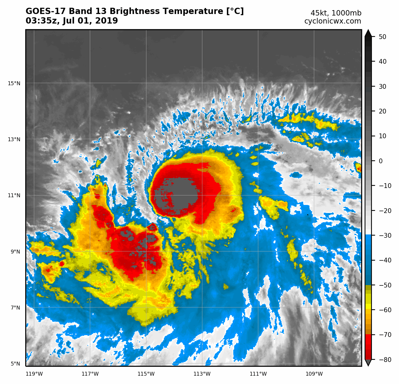
* BARBARA EP022019 07/01/19 00 UTC *
TIME (HR) 0 6 12 18 24 36 48 60 72 84 96 108 120
V (KT) NO LAND 45 51 59 67 77 91 101 105 97 88 82 69 60
V (KT) LAND 45 51 59 67 77 91 101 105 97 88 82 69 60
V (KT) LGEM 45 50 55 60 66 80 95 108 107 97 85 70 57
Storm Type TROP TROP TROP TROP TROP TROP TROP TROP TROP TROP TROP TROP TROP
SHEAR (KT) 9 9 8 6 8 15 9 2 5 6 11 19 18
SHEAR ADJ (KT) 6 1 0 0 0 -4 -4 -3 -2 2 5 6 9
SHEAR DIR 314 320 350 359 73 64 53 327 260 254 243 245 249
SST (C) 29.2 29.1 28.9 28.9 28.7 28.9 28.7 28.2 27.6 27.2 27.0 26.0 26.2
POT. INT. (KT) 159 158 155 155 153 154 152 146 139 135 134 124 126
200 MB T (C) -51.8 -52.3 -52.6 -52.3 -51.9 -52.4 -51.8 -52.2 -51.5 -51.9 -51.2 -51.6 -51.6
200 MB VXT (C) 0.2 0.2 0.3 0.3 0.3 0.4 0.4 0.5 0.5 0.7 0.6 0.8 0.6
TH_E DEV (C) 6 5 5 5 5 4 5 4 5 4 4 4 4
700-500 MB RH 72 70 70 69 70 70 67 61 55 52 49 46 43
MODEL VTX (KT) 20 20 22 23 27 29 31 32 30 29 30 26 24
850 MB ENV VOR 12 6 3 8 14 24 34 53 63 58 53 52 57
200 MB DIV 133 116 107 119 142 101 133 71 60 52 67 31 19
700-850 TADV -10 -12 -12 -10 -5 -5 -5 -4 1 4 3 -4 5
LAND (KM) 1290 1388 1432 1486 1551 1687 1765 1854 1922 1987 2051 2166 2194
LAT (DEG N) 10.9 11.2 11.5 11.7 11.9 12.2 12.8 13.5 14.2 14.9 15.7 16.2 16.4
LONG(DEG W) 113.2 114.8 116.3 117.7 119.0 121.3 123.3 125.3 126.8 128.3 130.0 131.9 134.3
STM SPEED (KT) 17 15 14 13 12 10 10 9 8 8 9 10 12
HEAT CONTENT 22 19 17 20 25 37 48 10 6 6 7 0 1
FORECAST TRACK FROM OFCI INITIAL HEADING/SPEED (DEG/KT):275/ 18 CX,CY: -17/ 2
T-12 MAX WIND: 35 PRESSURE OF STEERING LEVEL (MB): 661 (MEAN=587)
GOES IR BRIGHTNESS TEMP. STD DEV. 50-200 KM RAD: 9.2 (MEAN=14.5)
% GOES IR PIXELS WITH T < -20 C 50-200 KM RAD: 98.0 (MEAN=65.0)
PRELIM RI PROB (DV .GE. 35 KT IN 36 HR): 66.2
INDIVIDUAL CONTRIBUTIONS TO INTENSITY CHANGE
6 12 18 24 36 48 60 72 84 96 108 120
----------------------------------------------------------
SAMPLE MEAN CHANGE 0. 0. 1. 1. 1. 2. 1. 1. 1. 0. -1. -1.
SST POTENTIAL 0. 1. 2. 3. 6. 9. 12. 15. 16. 17. 18. 17.
VERTICAL SHEAR MAG 0. 1. 1. 2. 1. 2. 3. 5. 5. 6. 5. 4.
VERTICAL SHEAR ADJ 0. 0. 0. -1. 0. 1. 1. 1. 0. 0. 0. 0.
VERTICAL SHEAR DIR 0. -1. -1. 0. 2. 4. 5. 2. 0. -2. -3. -4.
PERSISTENCE 2. 3. 3. 3. 3. 2. 2. 2. 1. 2. 1. 2.
200/250 MB TEMP. 0. 0. 0. -1. -1. -1. -1. -1. 0. 0. 1. 1.
THETA_E EXCESS 0. 0. 0. -1. -1. -2. -3. -3. -4. -4. -5. -5.
700-500 MB RH 0. 0. 0. 0. 1. 1. 1. 1. 0. 0. 0. 0.
MODEL VTX TENDENCY 0. 1. 2. 5. 6. 10. 14. 14. 13. 13. 8. 5.
850 MB ENV VORTICITY 0. 0. 0. 0. 0. 0. 0. 0. 0. 0. 0. 0.
200 MB DIVERGENCE 0. 1. 1. 2. 2. 3. 5. 6. 6. 7. 6. 4.
850-700 T ADVEC 0. 0. 0. 0. 0. 0. 0. 0. 0. 0. 0. 0.
ZONAL STORM MOTION 0. 1. 1. 2. 3. 4. 5. 4. 3. 3. 3. 3.
STEERING LEVEL PRES 0. 0. 0. 1. 1. 1. 1. 1. 2. 2. 2. 2.
DAYS FROM CLIM. PEAK 0. 0. 0. 0. 0. 0. 0. -1. -1. -2. -2. -2.
GOES PREDICTORS 1. 2. 3. 3. 3. 2. 3. 3. 2. 2. 3. 3.
OCEAN HEAT CONTENT 0. 0. 0. 0. 0. 1. 1. 0. 0. 0. 0. 0.
RI POTENTIAL 2. 5. 9. 13. 20. 18. 11. 3. -2. -7. -10. -12.
----------------------------------------------------------
TOTAL CHANGE 6. 14. 22. 32. 46. 56. 60. 52. 43. 37. 24. 15.
CURRENT MAX WIND (KT): 45. LAT, LON: 10.9 113.2
** 2019 E. Pacific RI INDEX EP022019 BARBARA 07/01/19 00 UTC **
(SHIPS-RII PREDICTOR TABLE for 30 KT OR MORE MAXIMUM WIND INCREASE IN NEXT 24-h)
Predictor Value RI Predictor Range Scaled Value(0-1) % Contribution
POT = MPI-VMAX (KT) : 111.0 40.5 to 149.3 0.65 7.6
12 HR PERSISTENCE (KT) : 10.0 -22.0 to 44.0 0.48 8.4
850-200 MB SHEAR (KT) : 7.8 19.6 to 1.6 0.66 9.4
D200 (10**7s-1) : 123.4 -33.0 to 156.2 0.83 9.5
MAXIMUM WIND (KT) : 45.0 22.5 to 132.0 0.64 7.3
HEAT CONTENT (KJ/CM2) : 20.6 2.7 to 106.7 0.17 1.6
STD DEV OF IR BR TEMP : 9.2 37.8 to 2.1 0.80 8.0
BL DRY-AIR FLUX (W/M2) : 135.2 800.8 to -82.5 0.75 0.0
2nd PC OF IR BR TEMP : -0.3 2.2 to -1.9 0.60 0.7
%area of TPW <45 mm upshear : 0.0 62.3 to 0.0 1.00 -0.4
SHIPS Prob RI for 20kt/ 12hr RI threshold= 21% is 3.5 times climatological mean ( 6.1%)
SHIPS Prob RI for 25kt/ 24hr RI threshold= 68% is 5.4 times climatological mean (12.5%)
SHIPS Prob RI for 30kt/ 24hr RI threshold= 52% is 6.2 times climatological mean ( 8.4%)
SHIPS Prob RI for 35kt/ 24hr RI threshold= 39% is 6.5 times climatological mean ( 6.0%)
SHIPS Prob RI for 40kt/ 24hr RI threshold= 27% is 6.8 times climatological mean ( 4.0%)
SHIPS Prob RI for 45kt/ 36hr RI threshold= 55% is 8.5 times climatological mean ( 6.5%)
SHIPS Prob RI for 55kt/ 48hr RI threshold= 65% is 11.0 times climatological mean ( 5.9%)
SHIPS Prob RI for 65kt/ 72hr RI threshold= 43% is 8.9 times climatological mean ( 4.8%)
Matrix of RI probabilities
------------------------------------------------------------------------------
RI (kt / h) | 20/12 | 25/24 | 30/24 | 35/24 | 40/24 | 45/36 | 55/48 |65/72
------------------------------------------------------------------------------
SHIPS-RII: 21.1% 68.1% 52.1% 39.3% 27.4% 55.3% 65.0% 42.6%
Logistic: 35.6% 74.7% 62.0% 53.6% 19.7% 18.0% 4.8% 5.7%
Bayesian: 41.9% 49.8% 55.9% 31.6% 4.1% 17.3% 9.7% 0.2%
Consensus: 32.9% 64.2% 56.6% 41.5% 17.1% 30.2% 26.5% 16.2%
DTOPS: 23.0% 52.0% 32.0% 19.0% 12.0% 34.0% 34.0% 42.0%
## ANNULAR HURRICANE INDEX (AHI) EP022019 BARBARA 07/01/19 00 UTC ##
## STORM NOT ANNULAR, SCREENING STEP FAILED, NPASS=3 NFAIL=4 ##
## AHI= 0 (AHI OF 100 IS BEST FIT TO ANN. STRUC., 1 IS MARGINAL, 0 IS NOT ANNULAR) ##
* IR SAT DATA AVAILABLE, OHC AVAILABLE *
* BARBARA EP022019 07/01/19 00 UTC *
TIME (HR) 0 6 12 18 24 36 48 60 72 84 96 108 120
V (KT) NO LAND 45 51 59 67 77 91 101 105 97 88 82 69 60
V (KT) LAND 45 51 59 67 77 91 101 105 97 88 82 69 60
V (KT) LGEM 45 50 55 60 66 80 95 108 107 97 85 70 57
Storm Type TROP TROP TROP TROP TROP TROP TROP TROP TROP TROP TROP TROP TROP
SHEAR (KT) 9 9 8 6 8 15 9 2 5 6 11 19 18
SHEAR ADJ (KT) 6 1 0 0 0 -4 -4 -3 -2 2 5 6 9
SHEAR DIR 314 320 350 359 73 64 53 327 260 254 243 245 249
SST (C) 29.2 29.1 28.9 28.9 28.7 28.9 28.7 28.2 27.6 27.2 27.0 26.0 26.2
POT. INT. (KT) 159 158 155 155 153 154 152 146 139 135 134 124 126
200 MB T (C) -51.8 -52.3 -52.6 -52.3 -51.9 -52.4 -51.8 -52.2 -51.5 -51.9 -51.2 -51.6 -51.6
200 MB VXT (C) 0.2 0.2 0.3 0.3 0.3 0.4 0.4 0.5 0.5 0.7 0.6 0.8 0.6
TH_E DEV (C) 6 5 5 5 5 4 5 4 5 4 4 4 4
700-500 MB RH 72 70 70 69 70 70 67 61 55 52 49 46 43
MODEL VTX (KT) 20 20 22 23 27 29 31 32 30 29 30 26 24
850 MB ENV VOR 12 6 3 8 14 24 34 53 63 58 53 52 57
200 MB DIV 133 116 107 119 142 101 133 71 60 52 67 31 19
700-850 TADV -10 -12 -12 -10 -5 -5 -5 -4 1 4 3 -4 5
LAND (KM) 1290 1388 1432 1486 1551 1687 1765 1854 1922 1987 2051 2166 2194
LAT (DEG N) 10.9 11.2 11.5 11.7 11.9 12.2 12.8 13.5 14.2 14.9 15.7 16.2 16.4
LONG(DEG W) 113.2 114.8 116.3 117.7 119.0 121.3 123.3 125.3 126.8 128.3 130.0 131.9 134.3
STM SPEED (KT) 17 15 14 13 12 10 10 9 8 8 9 10 12
HEAT CONTENT 22 19 17 20 25 37 48 10 6 6 7 0 1
FORECAST TRACK FROM OFCI INITIAL HEADING/SPEED (DEG/KT):275/ 18 CX,CY: -17/ 2
T-12 MAX WIND: 35 PRESSURE OF STEERING LEVEL (MB): 661 (MEAN=587)
GOES IR BRIGHTNESS TEMP. STD DEV. 50-200 KM RAD: 9.2 (MEAN=14.5)
% GOES IR PIXELS WITH T < -20 C 50-200 KM RAD: 98.0 (MEAN=65.0)
PRELIM RI PROB (DV .GE. 35 KT IN 36 HR): 66.2
INDIVIDUAL CONTRIBUTIONS TO INTENSITY CHANGE
6 12 18 24 36 48 60 72 84 96 108 120
----------------------------------------------------------
SAMPLE MEAN CHANGE 0. 0. 1. 1. 1. 2. 1. 1. 1. 0. -1. -1.
SST POTENTIAL 0. 1. 2. 3. 6. 9. 12. 15. 16. 17. 18. 17.
VERTICAL SHEAR MAG 0. 1. 1. 2. 1. 2. 3. 5. 5. 6. 5. 4.
VERTICAL SHEAR ADJ 0. 0. 0. -1. 0. 1. 1. 1. 0. 0. 0. 0.
VERTICAL SHEAR DIR 0. -1. -1. 0. 2. 4. 5. 2. 0. -2. -3. -4.
PERSISTENCE 2. 3. 3. 3. 3. 2. 2. 2. 1. 2. 1. 2.
200/250 MB TEMP. 0. 0. 0. -1. -1. -1. -1. -1. 0. 0. 1. 1.
THETA_E EXCESS 0. 0. 0. -1. -1. -2. -3. -3. -4. -4. -5. -5.
700-500 MB RH 0. 0. 0. 0. 1. 1. 1. 1. 0. 0. 0. 0.
MODEL VTX TENDENCY 0. 1. 2. 5. 6. 10. 14. 14. 13. 13. 8. 5.
850 MB ENV VORTICITY 0. 0. 0. 0. 0. 0. 0. 0. 0. 0. 0. 0.
200 MB DIVERGENCE 0. 1. 1. 2. 2. 3. 5. 6. 6. 7. 6. 4.
850-700 T ADVEC 0. 0. 0. 0. 0. 0. 0. 0. 0. 0. 0. 0.
ZONAL STORM MOTION 0. 1. 1. 2. 3. 4. 5. 4. 3. 3. 3. 3.
STEERING LEVEL PRES 0. 0. 0. 1. 1. 1. 1. 1. 2. 2. 2. 2.
DAYS FROM CLIM. PEAK 0. 0. 0. 0. 0. 0. 0. -1. -1. -2. -2. -2.
GOES PREDICTORS 1. 2. 3. 3. 3. 2. 3. 3. 2. 2. 3. 3.
OCEAN HEAT CONTENT 0. 0. 0. 0. 0. 1. 1. 0. 0. 0. 0. 0.
RI POTENTIAL 2. 5. 9. 13. 20. 18. 11. 3. -2. -7. -10. -12.
----------------------------------------------------------
TOTAL CHANGE 6. 14. 22. 32. 46. 56. 60. 52. 43. 37. 24. 15.
CURRENT MAX WIND (KT): 45. LAT, LON: 10.9 113.2
** 2019 E. Pacific RI INDEX EP022019 BARBARA 07/01/19 00 UTC **
(SHIPS-RII PREDICTOR TABLE for 30 KT OR MORE MAXIMUM WIND INCREASE IN NEXT 24-h)
Predictor Value RI Predictor Range Scaled Value(0-1) % Contribution
POT = MPI-VMAX (KT) : 111.0 40.5 to 149.3 0.65 7.6
12 HR PERSISTENCE (KT) : 10.0 -22.0 to 44.0 0.48 8.4
850-200 MB SHEAR (KT) : 7.8 19.6 to 1.6 0.66 9.4
D200 (10**7s-1) : 123.4 -33.0 to 156.2 0.83 9.5
MAXIMUM WIND (KT) : 45.0 22.5 to 132.0 0.64 7.3
HEAT CONTENT (KJ/CM2) : 20.6 2.7 to 106.7 0.17 1.6
STD DEV OF IR BR TEMP : 9.2 37.8 to 2.1 0.80 8.0
BL DRY-AIR FLUX (W/M2) : 135.2 800.8 to -82.5 0.75 0.0
2nd PC OF IR BR TEMP : -0.3 2.2 to -1.9 0.60 0.7
%area of TPW <45 mm upshear : 0.0 62.3 to 0.0 1.00 -0.4
SHIPS Prob RI for 20kt/ 12hr RI threshold= 21% is 3.5 times climatological mean ( 6.1%)
SHIPS Prob RI for 25kt/ 24hr RI threshold= 68% is 5.4 times climatological mean (12.5%)
SHIPS Prob RI for 30kt/ 24hr RI threshold= 52% is 6.2 times climatological mean ( 8.4%)
SHIPS Prob RI for 35kt/ 24hr RI threshold= 39% is 6.5 times climatological mean ( 6.0%)
SHIPS Prob RI for 40kt/ 24hr RI threshold= 27% is 6.8 times climatological mean ( 4.0%)
SHIPS Prob RI for 45kt/ 36hr RI threshold= 55% is 8.5 times climatological mean ( 6.5%)
SHIPS Prob RI for 55kt/ 48hr RI threshold= 65% is 11.0 times climatological mean ( 5.9%)
SHIPS Prob RI for 65kt/ 72hr RI threshold= 43% is 8.9 times climatological mean ( 4.8%)
Matrix of RI probabilities
------------------------------------------------------------------------------
RI (kt / h) | 20/12 | 25/24 | 30/24 | 35/24 | 40/24 | 45/36 | 55/48 |65/72
------------------------------------------------------------------------------
SHIPS-RII: 21.1% 68.1% 52.1% 39.3% 27.4% 55.3% 65.0% 42.6%
Logistic: 35.6% 74.7% 62.0% 53.6% 19.7% 18.0% 4.8% 5.7%
Bayesian: 41.9% 49.8% 55.9% 31.6% 4.1% 17.3% 9.7% 0.2%
Consensus: 32.9% 64.2% 56.6% 41.5% 17.1% 30.2% 26.5% 16.2%
DTOPS: 23.0% 52.0% 32.0% 19.0% 12.0% 34.0% 34.0% 42.0%
## ANNULAR HURRICANE INDEX (AHI) EP022019 BARBARA 07/01/19 00 UTC ##
## STORM NOT ANNULAR, SCREENING STEP FAILED, NPASS=3 NFAIL=4 ##
## AHI= 0 (AHI OF 100 IS BEST FIT TO ANN. STRUC., 1 IS MARGINAL, 0 IS NOT ANNULAR) ##