https://twitter.com/RobertSpetaWX/status/1180844066554167298
WPAC: HAGIBIS - Post-Tropical
Moderator: S2k Moderators

Re: WPAC: HAGIBIS - Severe Tropical Storm
Probably not too far away from a nascent eye structure forming (<12 hours)

0 likes
Very useful information on the Dvorak Technique --
https://severe.worldweather.wmo.int/TCF ... kBeven.pdf
https://severe.worldweather.wmo.int/TCF ... kBeven.pdf
Re: WPAC: HAGIBIS - Severe Tropical Storm
0 likes
Very useful information on the Dvorak Technique --
https://severe.worldweather.wmo.int/TCF ... kBeven.pdf
https://severe.worldweather.wmo.int/TCF ... kBeven.pdf
Re: WPAC: HAGIBIS - Severe Tropical Storm
Last post for a bit -- would seem there are multiple hot towers rotating around the eyewall right now, heralding rapid deepening. Tons of latent heat release over a relatively small area.

0 likes
Very useful information on the Dvorak Technique --
https://severe.worldweather.wmo.int/TCF ... kBeven.pdf
https://severe.worldweather.wmo.int/TCF ... kBeven.pdf

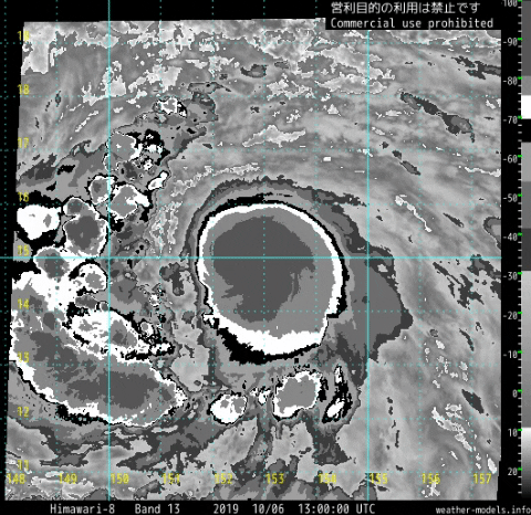
Re: WPAC: HAGIBIS - Tropical Storm
Hayabusa wrote:https://i.imgur.com/uhhMsCu.png
Can it go even deeper?GLOBAL MODEL DATA TIME 0000UTC 06.10.2019
TROPICAL STORM HAGIBIS ANALYSED POSITION : 14.8N 155.8E
LEAD CENTRAL MAXIMUM WIND
VERIFYING TIME TIME POSITION PRESSURE (MB) SPEED (KNOTS)
-------------- ---- -------- ------------- -------------
0000UTC 06.10.2019 0 14.8N 155.8E 1000 34
1200UTC 06.10.2019 12 14.7N 152.8E 990 48
0000UTC 07.10.2019 24 15.3N 149.5E 979 56
1200UTC 07.10.2019 36 16.2N 146.5E 966 67
0000UTC 08.10.2019 48 17.4N 143.4E 945 82
1200UTC 08.10.2019 60 18.5N 141.1E 927 94
0000UTC 09.10.2019 72 19.7N 139.5E 904 108
1200UTC 09.10.2019 84 21.2N 138.6E 894 107
0000UTC 10.10.2019 96 22.6N 137.6E 886 106
1200UTC 10.10.2019 108 23.8N 136.5E 891 99
0000UTC 11.10.2019 120 24.9N 134.8E 895 103
1200UTC 11.10.2019 132 26.4N 133.1E 883 106
0000UTC 12.10.2019 144 28.1N 131.3E 893 105
UKMET: Yes

GLOBAL MODEL DATA TIME 1200UTC 06.10.2019
SEVERE TROPICAL STORM HAGIBIS ANALYSED POSITION : 14.7N 152.6E
LEAD CENTRAL MAXIMUM WIND
VERIFYING TIME TIME POSITION PRESSURE (MB) SPEED (KNOTS)
-------------- ---- -------- ------------- -------------
1200UTC 06.10.2019 0 14.7N 152.6E 992 48
0000UTC 07.10.2019 12 15.3N 149.5E 982 55
1200UTC 07.10.2019 24 15.9N 146.5E 969 66
0000UTC 08.10.2019 36 16.9N 143.6E 946 82
1200UTC 08.10.2019 48 17.8N 141.1E 928 95
0000UTC 09.10.2019 60 18.9N 139.7E 899 107
1200UTC 09.10.2019 72 20.3N 138.6E 893 110
0000UTC 10.10.2019 84 21.6N 137.4E 878 109
1200UTC 10.10.2019 96 23.1N 136.0E 879 108
0000UTC 11.10.2019 108 24.5N 134.3E 874 109
1200UTC 11.10.2019 120 26.0N 132.6E 879 107
0000UTC 12.10.2019 132 27.5N 131.0E 890 103
1200UTC 12.10.2019 144 29.3N 130.4E 904 92
1 likes
ヤンデレ女が寝取られるているのを見たい!!!
ECMWF ensemble NWPAC plots: https://ecmwfensnwpac.imgbb.com/
Multimodel NWPAC plots: https://multimodelnwpac.imgbb.com/
GFS Ensemble NWPAC plots (16 & 35 day forecast): https://gefsnwpac.imgbb.com/
Plots updated automatically
ECMWF ensemble NWPAC plots: https://ecmwfensnwpac.imgbb.com/
Multimodel NWPAC plots: https://multimodelnwpac.imgbb.com/
GFS Ensemble NWPAC plots (16 & 35 day forecast): https://gefsnwpac.imgbb.com/
Plots updated automatically
-
mrbagyo

- Category 5

- Posts: 3963
- Age: 33
- Joined: Thu Apr 12, 2012 9:18 am
- Location: 14.13N 120.98E
- Contact:
Re: WPAC: HAGIBIS - Severe Tropical Storm
Can this support a CDG?

And am I reading it right? TP is at 100 mb / temp is between -83 or -84
And am I reading it right? TP is at 100 mb / temp is between -83 or -84
1 likes
The posts in this forum are NOT official forecast and should not be used as such. They are just the opinion of the poster and may or may not be backed by sound meteorological data. They are NOT endorsed by any professional institution or storm2k.org. For official information, please refer to RSMC, NHC and NWS products.
-
euro6208
Re: WPAC: HAGIBIS - Severe Tropical Storm
TPPN10 PGTW 061523
A. TROPICAL STORM 20W (HAGIBIS)
B. 06/1450Z
C. 14.71N
D. 151.82E
E. FIVE/HMWRI8
F. T3.5/3.5/D1.5/24HRS STT: D0.5/03HRS
G. IR/EIR
H. REMARKS: 38A/PBO SBC/ANMTN. CNVCTN WRAPS .85 ON LOG10 SPIRAL
YIELDING A DT OF 3.5. MET YIELDS A 3.0 AND PT A 3.5. DBO DT.
I. ADDITIONAL POSITIONS:
06/1104Z 14.58N 152.77E MMHS
RICHARDSON
0 likes
-
euro6208
Re: WPAC: HAGIBIS - Severe Tropical Storm
TXPQ28 KNES 061500
TCSWNP
A. 20W (HAGIBIS)
B. 06/1430Z
C. 15.0N
D. 152.1E
E. THREE/HIMAWARI-8
F. T4.0/4.0/D2.0/24HRS
G. IR/EIR/SWIR/GMI/AMSU
H. REMARKS...THIS INTENSITY ESTIMATE WAS DERIVED USING 4 KM IR
DATA. 8/10 W BANDING FOR A DT=4.0 INCLUDING +0.5 ADJUSTMENT FOR
W. MET=3.5. PT=4.0. FT IS BASED ON PT SINCE CLOUD FEATURES ARE NOT
CLEAR-CUT AND AN ADJUSTMENT WAS MADE TO THE MET.
I. ADDL POSITIONS
06/0909Z 14.6N 153.4E GMI
06/1100Z 14.7N 152.7E AMSU
...LEE
0 likes
Re: WPAC: HAGIBIS - Severe Tropical Storm
Already updated 18Z even if it's not 18Z yet, maybe they'll update again when 18Z actually comes.
20W HAGIBIS 191006 1800 14.8N 151.2E WPAC 60 978
0 likes
ヤンデレ女が寝取られるているのを見たい!!!
ECMWF ensemble NWPAC plots: https://ecmwfensnwpac.imgbb.com/
Multimodel NWPAC plots: https://multimodelnwpac.imgbb.com/
GFS Ensemble NWPAC plots (16 & 35 day forecast): https://gefsnwpac.imgbb.com/
Plots updated automatically
ECMWF ensemble NWPAC plots: https://ecmwfensnwpac.imgbb.com/
Multimodel NWPAC plots: https://multimodelnwpac.imgbb.com/
GFS Ensemble NWPAC plots (16 & 35 day forecast): https://gefsnwpac.imgbb.com/
Plots updated automatically
Re: WPAC: HAGIBIS - Severe Tropical Storm
mrbagyo wrote:Can this support a CDG?
https://s3.gifyu.com/images/2019100612.91212.stuve10.parc3.gif
And am I reading it right? TP is at 100 mb / temp is between -83 or -84
It'll be close. Should manage cmg/t7.5 at least
0 likes
Very useful information on the Dvorak Technique --
https://severe.worldweather.wmo.int/TCF ... kBeven.pdf
https://severe.worldweather.wmo.int/TCF ... kBeven.pdf
Re: WPAC: HAGIBIS - Typhoon
Hayabusa wrote:Already updated 18Z even if it's not 18Z yet, maybe they'll update again when 18Z actually comes.20W HAGIBIS 191006 1800 14.8N 151.2E WPAC 60 978
Typhoon, a day later since being named
20W HAGIBIS 191006 1800 14.9N 151.2E WPAC 65 985
TY 1919 (Hagibis)
Issued at 18:50 UTC, 6 October 2019
<Analysis at 18 UTC, 6 October>
Scale -
Intensity -
Center position N14°55' (14.9°)
E151°10' (151.2°)
Direction and speed of movement WNW 30 km/h (16 kt)
Central pressure 975 hPa
Maximum wind speed near center 35 m/s (65 kt)
Maximum wind gust speed 50 m/s (95 kt)
≥ 50 kt wind area ALL 80 km (45 NM)
≥ 30 kt wind area ALL 440 km (240 NM)
2 likes
ヤンデレ女が寝取られるているのを見たい!!!
ECMWF ensemble NWPAC plots: https://ecmwfensnwpac.imgbb.com/
Multimodel NWPAC plots: https://multimodelnwpac.imgbb.com/
GFS Ensemble NWPAC plots (16 & 35 day forecast): https://gefsnwpac.imgbb.com/
Plots updated automatically
ECMWF ensemble NWPAC plots: https://ecmwfensnwpac.imgbb.com/
Multimodel NWPAC plots: https://multimodelnwpac.imgbb.com/
GFS Ensemble NWPAC plots (16 & 35 day forecast): https://gefsnwpac.imgbb.com/
Plots updated automatically
-
Cunxi Huang

- Category 1

- Posts: 329
- Age: 27
- Joined: Thu Sep 26, 2013 12:17 pm
- Location: San Jose, CA
- Contact:
Re: WPAC: HAGIBIS - Severe Tropical Storm
Holy dang 12z Euro quotes an 898 mb by TAU+78. It's happening.
WP, 20, 2019100612, 98, EMDT, 78, 209N, 1375E, 101, 898, , 34, NEQ, 0, 0, 0, 0, 0, 0, 25
WP, 20, 2019100612, 98, EMDT, 84, 216N, 1371E, 99, 898, , 34, NEQ, 0, 0, 0, 0, 0, 0, 18
1 likes
06 SuTY SAOMAI | 09 TY LINFA | 10 TY FANAPI | 10 SuTY MEGI | 16 SuTY MERANTI | 19 SuTY LEKIMA | 24 C2 FRANCINE
DO NOT use my posts for life and death decisions. For official information, please refer to products from your RSMC and national weather agency.
DO NOT use my posts for life and death decisions. For official information, please refer to products from your RSMC and national weather agency.
-
1900hurricane

- Category 5
- Posts: 6063
- Age: 34
- Joined: Fri Feb 06, 2015 12:04 pm
- Location: Houston, TX
- Contact:
Re: WPAC: HAGIBIS - Typhoon
Who wants to take a crack at where the center is?

1 likes
Contract Meteorologist. TAMU & MSST. Fiercely authentic, one of a kind. We are all given free will, so choose a life meant to be lived. We are the Masters of our own Stories.
Opinions expressed are mine alone.
Follow me on Twitter at @1900hurricane : Read blogs at https://1900hurricane.wordpress.com/
Opinions expressed are mine alone.
Follow me on Twitter at @1900hurricane : Read blogs at https://1900hurricane.wordpress.com/

Re: WPAC: HAGIBIS - Tropical Storm
Hayabusa wrote:Hayabusa wrote:https://i.imgur.com/uhhMsCu.png
Can it go even deeper?GLOBAL MODEL DATA TIME 0000UTC 06.10.2019
TROPICAL STORM HAGIBIS ANALYSED POSITION : 14.8N 155.8E
LEAD CENTRAL MAXIMUM WIND
VERIFYING TIME TIME POSITION PRESSURE (MB) SPEED (KNOTS)
-------------- ---- -------- ------------- -------------
0000UTC 06.10.2019 0 14.8N 155.8E 1000 34
1200UTC 06.10.2019 12 14.7N 152.8E 990 48
0000UTC 07.10.2019 24 15.3N 149.5E 979 56
1200UTC 07.10.2019 36 16.2N 146.5E 966 67
0000UTC 08.10.2019 48 17.4N 143.4E 945 82
1200UTC 08.10.2019 60 18.5N 141.1E 927 94
0000UTC 09.10.2019 72 19.7N 139.5E 904 108
1200UTC 09.10.2019 84 21.2N 138.6E 894 107
0000UTC 10.10.2019 96 22.6N 137.6E 886 106
1200UTC 10.10.2019 108 23.8N 136.5E 891 99
0000UTC 11.10.2019 120 24.9N 134.8E 895 103
1200UTC 11.10.2019 132 26.4N 133.1E 883 106
0000UTC 12.10.2019 144 28.1N 131.3E 893 105
UKMET: Yes
https://i.imgur.com/DbE44Av.pngGLOBAL MODEL DATA TIME 1200UTC 06.10.2019
SEVERE TROPICAL STORM HAGIBIS ANALYSED POSITION : 14.7N 152.6E
LEAD CENTRAL MAXIMUM WIND
VERIFYING TIME TIME POSITION PRESSURE (MB) SPEED (KNOTS)
-------------- ---- -------- ------------- -------------
1200UTC 06.10.2019 0 14.7N 152.6E 992 48
0000UTC 07.10.2019 12 15.3N 149.5E 982 55
1200UTC 07.10.2019 24 15.9N 146.5E 969 66
0000UTC 08.10.2019 36 16.9N 143.6E 946 82
1200UTC 08.10.2019 48 17.8N 141.1E 928 95
0000UTC 09.10.2019 60 18.9N 139.7E 899 107
1200UTC 09.10.2019 72 20.3N 138.6E 893 110
0000UTC 10.10.2019 84 21.6N 137.4E 878 109
1200UTC 10.10.2019 96 23.1N 136.0E 879 108
0000UTC 11.10.2019 108 24.5N 134.3E 874 109
1200UTC 11.10.2019 120 26.0N 132.6E 879 107
0000UTC 12.10.2019 132 27.5N 131.0E 890 103
1200UTC 12.10.2019 144 29.3N 130.4E 904 92
I would not be surprised if we have a power Category 5 super typhoon later this week.

1 likes
-
Cunxi Huang
- Category 1
- Posts: 329
- Age: 27
- Joined: Thu Sep 26, 2013 12:17 pm
- Location: San Jose, CA
- Contact:
Re: WPAC: HAGIBIS - Typhoon
Actually UK goes as low as 873 mb. Don't thank me. 
WP, 20, 2019100612, 03, UKM, 114, 252N, 1335E, 109, 873, TY, 34, NEQ, 258, 235, 214, 252, , , 32, , , W, , , , , HAGIBIS, 0, , 0, , 0, 0, 0, 0,
1 likes
06 SuTY SAOMAI | 09 TY LINFA | 10 TY FANAPI | 10 SuTY MEGI | 16 SuTY MERANTI | 19 SuTY LEKIMA | 24 C2 FRANCINE
DO NOT use my posts for life and death decisions. For official information, please refer to products from your RSMC and national weather agency.
DO NOT use my posts for life and death decisions. For official information, please refer to products from your RSMC and national weather agency.
-
1900hurricane
- Category 5
- Posts: 6063
- Age: 34
- Joined: Fri Feb 06, 2015 12:04 pm
- Location: Houston, TX
- Contact:
Re: WPAC: HAGIBIS - Typhoon
0 likes
Contract Meteorologist. TAMU & MSST. Fiercely authentic, one of a kind. We are all given free will, so choose a life meant to be lived. We are the Masters of our own Stories.
Opinions expressed are mine alone.
Follow me on Twitter at @1900hurricane : Read blogs at https://1900hurricane.wordpress.com/
Opinions expressed are mine alone.
Follow me on Twitter at @1900hurricane : Read blogs at https://1900hurricane.wordpress.com/
-
1900hurricane
- Category 5
- Posts: 6063
- Age: 34
- Joined: Fri Feb 06, 2015 12:04 pm
- Location: Houston, TX
- Contact:
Re: WPAC: HAGIBIS - Typhoon
Probably time to switch from curved band to embedded center for the next fix by the agencies.

2 likes
Contract Meteorologist. TAMU & MSST. Fiercely authentic, one of a kind. We are all given free will, so choose a life meant to be lived. We are the Masters of our own Stories.
Opinions expressed are mine alone.
Follow me on Twitter at @1900hurricane : Read blogs at https://1900hurricane.wordpress.com/
Opinions expressed are mine alone.
Follow me on Twitter at @1900hurricane : Read blogs at https://1900hurricane.wordpress.com/
Re: WPAC: HAGIBIS - Typhoon
Pretty sure multiple model records have been broken here. Never seen the ICON, UKmet, or Euro explicit forecast a storm to deepen to such an extreme degree.
0 likes
Very useful information on the Dvorak Technique --
https://severe.worldweather.wmo.int/TCF ... kBeven.pdf
https://severe.worldweather.wmo.int/TCF ... kBeven.pdf
-
1900hurricane
- Category 5
- Posts: 6063
- Age: 34
- Joined: Fri Feb 06, 2015 12:04 pm
- Location: Houston, TX
- Contact:
Re: WPAC: HAGIBIS - Typhoon
Up comes the sun.

2 likes
Contract Meteorologist. TAMU & MSST. Fiercely authentic, one of a kind. We are all given free will, so choose a life meant to be lived. We are the Masters of our own Stories.
Opinions expressed are mine alone.
Follow me on Twitter at @1900hurricane : Read blogs at https://1900hurricane.wordpress.com/
Opinions expressed are mine alone.
Follow me on Twitter at @1900hurricane : Read blogs at https://1900hurricane.wordpress.com/
Re: WPAC: HAGIBIS - Typhoon
Multiple banding features. Shear is literally nill. Sky's the limit on this b*stard.

2 likes
Very useful information on the Dvorak Technique --
https://severe.worldweather.wmo.int/TCF ... kBeven.pdf
https://severe.worldweather.wmo.int/TCF ... kBeven.pdf
Who is online
Users browsing this forum: No registered users and 11 guests