Hurricane Barbara Discussion Number 8
NWS National Hurricane Center Miami FL EP022019
1100 PM HST Mon Jul 01 2019
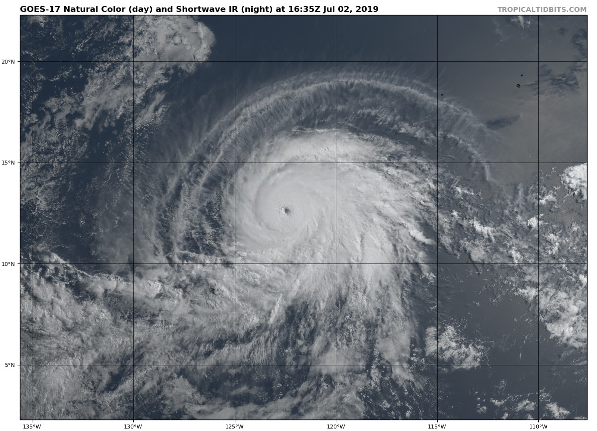
Recent METOP-A and -B microwave images indicate that Barbara's
eyewall is no longer broken and has been able to shield itself from
the dry air that had been penetrating the inner core. An eye is
also becoming more apparent in infrared satellite imagery.
Subjective Dvorak estimate have increased to T5.0/90 kt from TAFB
and T5.5/102 kt from SAB, while objective numbers are T5.5/102 kt
and 81 kt from UW-CIMSS ADT and SATCON, respectively. Barbara's
initial intensity is therefore set at 95 kt, meaning that the rapid
intensification phase continues.
Low vertical shear, beneficial upper-level outflow, and deep warm
water are likely to foster additional strengthening for the next
24-36 hours, with Barbara expected to become a major hurricane
soon. Oceanic heat content values decrease markedly by 36 hours,
which should lead to gradual weakening, followed by faster weakening
on days 4 and 5 when southwesterly shear increases. The updated NHC
intensity forecast is not too dissimilar from the previous forecast
during the first day or two and still shows Barbara's peak intensity
reaching category 4 intensity during that period. The models are in
good agreement that environmental conditions will become quite
hostile after day 3, and the new forecast shows a faster weakening
rate toward the end of the forecast period. In fact, if the GFS
and European models are correct, Barbara could lose its deep
convection and become a post-tropical cyclone over the weekend.
Barbara's trajectory remains westward at 280/13 kt, with steering
dominated by a subtropical ridge which extends westward from
northern Mexico. The hurricane is expected to gradually reach the
western periphery of the ridge in the coming days, which should
cause it to turn northwestward and slow down by 48-72 hours. After
that time, a weaker Barbara should turn back toward the west and
accelerate, steered by lower-level trade winds. Negligible
adjustments, primarily after 48 hours, were made to the NHC official
track forecast, which lies close to the TVDG multi-model consensus.
NOTE: Beginning this hurricane season, all National Hurricane
Center eastern Pacific advisory products that utilize local time,
and the corresponding graphical products, will use Hawaiian Standard
Time (HST) instead of Pacific Daylight Time (PDT) or Standard Time
(PST) if the final forecast point is west of 140W. Since Barbara's
day 5 official forecast point is now west of 140W, advisory products
are now being issued in Hawaiian Standard Time.
FORECAST POSITIONS AND MAX WINDS
INIT 02/0900Z 12.0N 121.1W 95 KT 110 MPH
12H 02/1800Z 12.4N 122.9W 105 KT 120 MPH
24H 03/0600Z 13.0N 125.0W 115 KT 130 MPH
36H 03/1800Z 13.8N 126.9W 120 KT 140 MPH
48H 04/0600Z 14.7N 128.6W 110 KT 125 MPH
72H 05/0600Z 16.9N 132.0W 80 KT 90 MPH
96H 06/0600Z 18.5N 136.0W 55 KT 65 MPH
120H 07/0600Z 19.0N 141.5W 40 KT 45 MPH
$$
Forecaster Berg