

WPAC: HAGIBIS - Post-Tropical
Moderator: S2k Moderators
Re: WPAC: HAGIBIS - Typhoon
Pinhole eye forming LOL
0 likes
Very useful information on the Dvorak Technique --
https://severe.worldweather.wmo.int/TCF ... kBeven.pdf
https://severe.worldweather.wmo.int/TCF ... kBeven.pdf

Re: WPAC: HAGIBIS - Typhoon
TY 1919 (Hagibis)
Issued at 21:45 UTC, 6 October 2019
<Analysis at 21 UTC, 6 October>
Scale -
Intensity -
Center position N15°00' (15.0°)
E150°25' (150.4°)
Direction and speed of movement WNW 30 km/h (16 kt)
Central pressure 970 hPa
Maximum wind speed near center 35 m/s (70 kt)
Maximum wind gust speed 50 m/s (100 kt)
≥ 50 kt wind area ALL 90 km (50 NM)
≥ 30 kt wind area ALL 440 km (240 NM)
1 likes
ヤンデレ女が寝取られるているのを見たい!!!
ECMWF ensemble NWPAC plots: https://ecmwfensnwpac.imgbb.com/
Multimodel NWPAC plots: https://multimodelnwpac.imgbb.com/
GFS Ensemble NWPAC plots (16 & 35 day forecast): https://gefsnwpac.imgbb.com/
Plots updated automatically
ECMWF ensemble NWPAC plots: https://ecmwfensnwpac.imgbb.com/
Multimodel NWPAC plots: https://multimodelnwpac.imgbb.com/
GFS Ensemble NWPAC plots (16 & 35 day forecast): https://gefsnwpac.imgbb.com/
Plots updated automatically
Re: WPAC: HAGIBIS - Typhoon
Loop of the some of the better microwave passes:
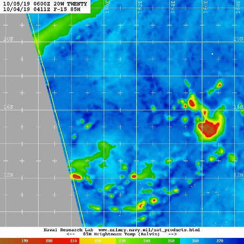
2 likes
Very useful information on the Dvorak Technique --
https://severe.worldweather.wmo.int/TCF ... kBeven.pdf
https://severe.worldweather.wmo.int/TCF ... kBeven.pdf

Re: WPAC: HAGIBIS - Typhoon
CURRENT ESTIMATE
Date (mmddhhmm): 10061924
SATCON: MSLP = 964 hPa MSW = 90 knots
SATCON Member Consensus: 90.0 knots
Pressure -> Wind Using SATCON MSLP: 86 knots
Distance to Outer Closed Isobar Used is 250 nm
Eye Size Correction Used is 0 knots Source: NA
Member Estimates
ADT: 986 hPa 61 knots Scene: CDO Date: OCT062110
CIMSS AMSU: 950 hPa 111 knots Bias Corr: 0 (MW) Date: 10061924
ATMS: 975.0 hPa 67.9 knots Date: 10061454
SSMIS: 975.0 hPa 67.9 knots Date: 10061454
CIRA ATMS: 991 hPa 46 knots Date:
0 likes
ヤンデレ女が寝取られるているのを見たい!!!
ECMWF ensemble NWPAC plots: https://ecmwfensnwpac.imgbb.com/
Multimodel NWPAC plots: https://multimodelnwpac.imgbb.com/
GFS Ensemble NWPAC plots (16 & 35 day forecast): https://gefsnwpac.imgbb.com/
Plots updated automatically
ECMWF ensemble NWPAC plots: https://ecmwfensnwpac.imgbb.com/
Multimodel NWPAC plots: https://multimodelnwpac.imgbb.com/
GFS Ensemble NWPAC plots (16 & 35 day forecast): https://gefsnwpac.imgbb.com/
Plots updated automatically
Re: WPAC: HAGIBIS - Typhoon
Never seen anything like this 

0 likes
Very useful information on the Dvorak Technique --
https://severe.worldweather.wmo.int/TCF ... kBeven.pdf
https://severe.worldweather.wmo.int/TCF ... kBeven.pdf
-
1900hurricane

- Category 5

- Posts: 6063
- Age: 34
- Joined: Fri Feb 06, 2015 12:04 pm
- Location: Houston, TX
- Contact:
Re: WPAC: HAGIBIS - Typhoon
1900hurricane wrote:Probably time to switch from curved band to embedded center for the next fix by the agencies.
https://i.imgur.com/s5PinqC.gif
Denied by JTWC.
TPPN10 PGTW 062122
A. TYPHOON 20W (E OF GUAM)
B. 06/2050Z
C. 15.03N
D. 150.02E
E. FIVE/HMWRI8
F. T4.0/4.0/D1.5/24HRS STT: S0.0/03HRS
G. IR/EIR/VIS/MSI
H. REMARKS: 40A/PBO SBC/ANMTN. CNVCTN WRAPS 1.0 ON LOG10 SPIRAL
YIELDING A DT OF 3.5 ADDED .5 FOR ALL WHITE BAND. MET IS 4.0.
PT IS 3.5. DBO DT.
I. ADDITIONAL POSITIONS:
06/1550Z 14.87N 151.88E AMS2
06/1742Z 14.92N 151.20E SSMS
MARTIN
0 likes
Contract Meteorologist. TAMU & MSST. Fiercely authentic, one of a kind. We are all given free will, so choose a life meant to be lived. We are the Masters of our own Stories.
Opinions expressed are mine alone.
Follow me on Twitter at @1900hurricane : Read blogs at https://1900hurricane.wordpress.com/
Opinions expressed are mine alone.
Follow me on Twitter at @1900hurricane : Read blogs at https://1900hurricane.wordpress.com/
Re: WPAC: HAGIBIS - Severe Tropical Storm
mrbagyo wrote:Can this support a CDG?
https://s3.gifyu.com/images/2019100612.91212.stuve10.parc3.gif
And am I reading it right? TP is at 100 mb / temp is between -83 or -84
That's way up there. Storm on approach will likely modify/lift it even more.
1 likes
Very useful information on the Dvorak Technique --
https://severe.worldweather.wmo.int/TCF ... kBeven.pdf
https://severe.worldweather.wmo.int/TCF ... kBeven.pdf
Re: WPAC: HAGIBIS - Typhoon
Eye feature visible now.
Last edited by Highteeld on Sun Oct 06, 2019 5:35 pm, edited 1 time in total.
3 likes
Very useful information on the Dvorak Technique --
https://severe.worldweather.wmo.int/TCF ... kBeven.pdf
https://severe.worldweather.wmo.int/TCF ... kBeven.pdf
-
1900hurricane
- Category 5
- Posts: 6063
- Age: 34
- Joined: Fri Feb 06, 2015 12:04 pm
- Location: Houston, TX
- Contact:
Re: WPAC: HAGIBIS - Typhoon
It's probably passing north of Saipan, but with it still riding along near 15ºN now, I wouldn't feel too comfortable until it's actually a good deal north of the islands latitude.
0 likes
Contract Meteorologist. TAMU & MSST. Fiercely authentic, one of a kind. We are all given free will, so choose a life meant to be lived. We are the Masters of our own Stories.
Opinions expressed are mine alone.
Follow me on Twitter at @1900hurricane : Read blogs at https://1900hurricane.wordpress.com/
Opinions expressed are mine alone.
Follow me on Twitter at @1900hurricane : Read blogs at https://1900hurricane.wordpress.com/
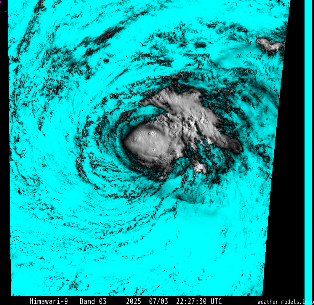
Re: WPAC: HAGIBIS - Typhoon
Highteeld wrote:Eye feature visible now.
https://weather-models.info/latest/images/himawari/target/vis/22/222730-vis-color.png
Would estimate around 85 knots right now. JMA at 70 knots (2 hours ago) 10 min avg would be close given current satellite trends. AMSU still running hot, which is screw up SatCon a bit.
1 likes
Very useful information on the Dvorak Technique --
https://severe.worldweather.wmo.int/TCF ... kBeven.pdf
https://severe.worldweather.wmo.int/TCF ... kBeven.pdf
-
Tailspin
Re: WPAC: HAGIBIS - Typhoon
1900hurricane wrote:1900hurricane wrote:Probably time to switch from curved band to embedded center for the next fix by the agencies.
https://i.imgur.com/s5PinqC.gif
Denied by JTWC.TPPN10 PGTW 062122
A. TYPHOON 20W (E OF GUAM)
B. 06/2050Z
C. 15.03N
D. 150.02E
E. FIVE/HMWRI8
F. T4.0/4.0/D1.5/24HRS STT: S0.0/03HRS
G. IR/EIR/VIS/MSI
H. REMARKS: 40A/PBO SBC/ANMTN. CNVCTN WRAPS 1.0 ON LOG10 SPIRAL
YIELDING A DT OF 3.5 ADDED .5 FOR ALL WHITE BAND. MET IS 4.0.
PT IS 3.5. DBO DT.
I. ADDITIONAL POSITIONS:
06/1550Z 14.87N 151.88E AMS2
06/1742Z 14.92N 151.20E SSMS
MARTIN
Yeah just eyeballing many hours ago it look like there was a embedded center. Tbo i expected too see a entry level cat3 today.
2 likes
-
mrbagyo

- Category 5
- Posts: 3963
- Age: 33
- Joined: Thu Apr 12, 2012 9:18 am
- Location: 14.13N 120.98E
- Contact:
Re: WPAC: HAGIBIS - Typhoon


I see 45 knots pixels
Last edited by mrbagyo on Sun Oct 06, 2019 5:47 pm, edited 1 time in total.
0 likes
The posts in this forum are NOT official forecast and should not be used as such. They are just the opinion of the poster and may or may not be backed by sound meteorological data. They are NOT endorsed by any professional institution or storm2k.org. For official information, please refer to RSMC, NHC and NWS products.
-
1900hurricane
- Category 5
- Posts: 6063
- Age: 34
- Joined: Fri Feb 06, 2015 12:04 pm
- Location: Houston, TX
- Contact:
Re: WPAC: HAGIBIS - Typhoon
0 likes
Contract Meteorologist. TAMU & MSST. Fiercely authentic, one of a kind. We are all given free will, so choose a life meant to be lived. We are the Masters of our own Stories.
Opinions expressed are mine alone.
Follow me on Twitter at @1900hurricane : Read blogs at https://1900hurricane.wordpress.com/
Opinions expressed are mine alone.
Follow me on Twitter at @1900hurricane : Read blogs at https://1900hurricane.wordpress.com/
Re: WPAC: HAGIBIS - Typhoon
To hell with embedded center at this point. There's going to be no choice but go straight from Curved Band to Eye as the Scene Type by the next update at this rate. HA!
1 likes
Very useful information on the Dvorak Technique --
https://severe.worldweather.wmo.int/TCF ... kBeven.pdf
https://severe.worldweather.wmo.int/TCF ... kBeven.pdf
-
1900hurricane
- Category 5
- Posts: 6063
- Age: 34
- Joined: Fri Feb 06, 2015 12:04 pm
- Location: Houston, TX
- Contact:
Re: WPAC: HAGIBIS - Typhoon
I realize this is a pipe dream since there is a struggle to keep the one NEXRAD on Guam operating normally sometimes (what a debacle with Yutu that was last year), but I really wish there could be a second NEXRAD on Saipan. That would really extend Mariana radar coverage.
3 likes
Contract Meteorologist. TAMU & MSST. Fiercely authentic, one of a kind. We are all given free will, so choose a life meant to be lived. We are the Masters of our own Stories.
Opinions expressed are mine alone.
Follow me on Twitter at @1900hurricane : Read blogs at https://1900hurricane.wordpress.com/
Opinions expressed are mine alone.
Follow me on Twitter at @1900hurricane : Read blogs at https://1900hurricane.wordpress.com/

-
mrbagyo
- Category 5
- Posts: 3963
- Age: 33
- Joined: Thu Apr 12, 2012 9:18 am
- Location: 14.13N 120.98E
- Contact:
Re: WPAC: HAGIBIS - Typhoon
1900hurricane wrote:I realize this is a pipe dream since there is a struggle to keep the one NEXRAD on Guam operating normally sometimes (what a debacle with Yutu that was last year), but I really wish there could be a second NEXRAD on Saipan. That would really extend Mariana radar coverage.
I second that statement. Btw, what's the max range of this kind of radar. Some of radars used by CMA can cover 460 kms
0 likes
The posts in this forum are NOT official forecast and should not be used as such. They are just the opinion of the poster and may or may not be backed by sound meteorological data. They are NOT endorsed by any professional institution or storm2k.org. For official information, please refer to RSMC, NHC and NWS products.

Who is online
Users browsing this forum: No registered users and 21 guests