
ATL: DORIAN - Models
Moderator: S2k Moderators
Re: ATL: DORIAN - Models
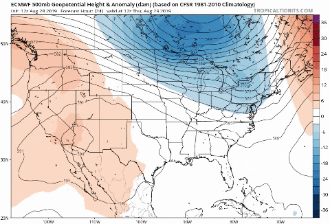
Latest Euro - This would be insane! Wow - god speed to everyone down there
0 likes
-
jlauderdal
- S2K Supporter

- Posts: 7240
- Joined: Wed May 19, 2004 5:46 am
- Location: NE Fort Lauderdale
- Contact:
Re: ATL: DORIAN - Models
dorian really slowed down after landfall, central ga at 168h..still a low in ga at 180 hours and has moved a little south
0 likes

Re: ATL: DORIAN - Models
What are the going odds of second landfall on the ConUS??? LMAO.
10-30% - from Mid Texas Coast to Louisiana/Mississippi Line
50-70% - Louisiana/Mississippi Line to Pensacola
10-30% - Pensacola to Big Bend
0-30% - No Second Landfall
that is what I'm going with, right now. I know it is over 100% but this is not an ordinary storm
10-30% - from Mid Texas Coast to Louisiana/Mississippi Line
50-70% - Louisiana/Mississippi Line to Pensacola
10-30% - Pensacola to Big Bend
0-30% - No Second Landfall
that is what I'm going with, right now. I know it is over 100% but this is not an ordinary storm
1 likes
Personal Forecast Disclaimer:
The posts in this forum are NOT official forecast and should not be used as such. They are just the opinion of the poster and may or may not be backed by sound meteorological data. They are NOT endorsed by any professional institution or storm2k.org. For official information, please refer to the NHC and NWS products.
The posts in this forum are NOT official forecast and should not be used as such. They are just the opinion of the poster and may or may not be backed by sound meteorological data. They are NOT endorsed by any professional institution or storm2k.org. For official information, please refer to the NHC and NWS products.

Re: ATL: DORIAN - Models
beachman80 wrote:jlauderdal wrote:jax landfall in 5 days...splitting the difference between the euro and gfs for a track is giving too much weight to the gfs, still have to respect the gfs but not 50/50..more like 70/30
GFS track is about 75-100 miles south of Jax. More like Daytona Beach.
That's what I see too. Maybe Ormond at the most, but I'm seeing Daytona or even the inlet between NSB and Port Orange. Definitely not Jax. Still, I think the GFS is too far north based on all of the others and its own ensemble. We shall see ..
0 likes
-
floridasun78
- Category 5

- Posts: 3755
- Joined: Sun May 17, 2009 10:16 pm
- Location: miami fl
Re: ATL: DORIAN - Models
my weather man in miami saying he like Euro nit have better record other models
0 likes
-
SunnyThoughts
- Category 5
- Posts: 2263
- Joined: Wed Jul 09, 2003 12:42 pm
- Location: Pensacola, Florida
Re: ATL: DORIAN - Models
Blinhart wrote:What are the going odds of second landfall on the ConUS??? LMAO.
10-30% - from Mid Texas Coast to Louisiana/Mississippi Line
50-70% - Louisiana/Mississippi Line to Pensacola
10-30% - Pensacola to Big Bend
0-30% - No Second Landfall
that is what I'm going with, right now. I know it is over 100% but this is not an ordinary storm
Lol, thanks for putting me into two of the catagories right in the middle
0 likes
-
beachman80
Re: ATL: DORIAN - Models
NFLnut wrote:beachman80 wrote:jlauderdal wrote:jax landfall in 5 days...splitting the difference between the euro and gfs for a track is giving too much weight to the gfs, still have to respect the gfs but not 50/50..more like 70/30
GFS track is about 75-100 miles south of Jax. More like Daytona Beach.
That's what I see too. Maybe Ormond at the most, but I'm seeing Daytona or even the inlet between NSB and Port Orange. Definitely not Jax. Still, I think the GFS is too far north based on all of the others and its own ensemble. We shall see ..
Agree. I think this could be Miami or Palm Beach. I'm also interested to see what happens if it gets into the Gulf as I've see everything from quick turns back into the west coast, to gradual turns north to NW beeline for Louisiana or Tx to the system even stalling out with no steering.
0 likes
Re: ATL: DORIAN - Models
SunnyThoughts wrote:Blinhart wrote:What are the going odds of second landfall on the ConUS??? LMAO.
10-30% - from Mid Texas Coast to Louisiana/Mississippi Line
50-70% - Louisiana/Mississippi Line to Pensacola
10-30% - Pensacola to Big Bend
0-30% - No Second Landfall
that is what I'm going with, right now. I know it is over 100% but this is not an ordinary storm
Lol, thanks for putting me into two of the catagories right in the middle
Well with the current models, it is looking like Pensacola is in the hot zone right now.
0 likes
Personal Forecast Disclaimer:
The posts in this forum are NOT official forecast and should not be used as such. They are just the opinion of the poster and may or may not be backed by sound meteorological data. They are NOT endorsed by any professional institution or storm2k.org. For official information, please refer to the NHC and NWS products.
The posts in this forum are NOT official forecast and should not be used as such. They are just the opinion of the poster and may or may not be backed by sound meteorological data. They are NOT endorsed by any professional institution or storm2k.org. For official information, please refer to the NHC and NWS products.
-
gatorcane

- S2K Supporter
- Posts: 23708
- Age: 48
- Joined: Sun Mar 13, 2005 3:54 pm
- Location: Boca Raton, FL
Re: ATL: DORIAN - Models
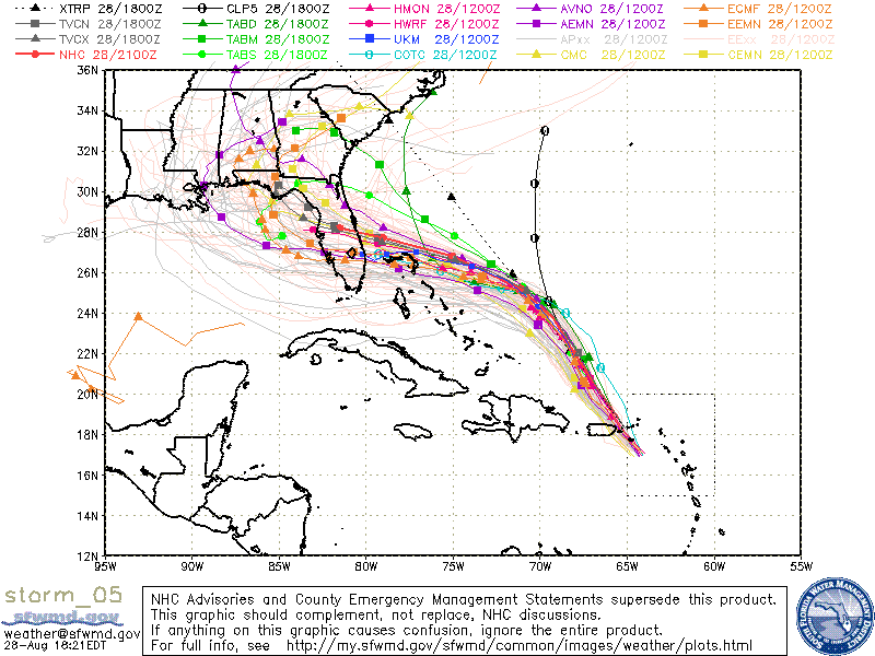
This map tells the story. With so much uncertainty, I like seeing the ensembles plotted as well. Note the stronger ensembles are the southern ones through South Florida:
Last edited by gatorcane on Wed Aug 28, 2019 5:35 pm, edited 1 time in total.
2 likes
Re: ATL: DORIAN - Models
beachman80 wrote:NFLnut wrote:beachman80 wrote:
GFS track is about 75-100 miles south of Jax. More like Daytona Beach.
That's what I see too. Maybe Ormond at the most, but I'm seeing Daytona or even the inlet between NSB and Port Orange. Definitely not Jax. Still, I think the GFS is too far north based on all of the others and its own ensemble. We shall see ..
Agree. I think this could be Miami or Palm Beach. I'm also interested to see what happens if it gets into the Gulf as I've see everything from quick turns back into the west coast, to gradual turns north to NW beeline for Louisiana or Tx to the system even stalling out with no steering.
No. I'm saying that the current GFS shows landfall at the inlet. But I'm thinking (or maybe hoping with the models southern trends so far today) landfall will probably happen no further north than Vero. Just based upon the EURO and the ICON, for all they're worth. UK also shows ~Palm Beach. Still, plenty of time for swings either way this far out.
1 likes

Re: ATL: DORIAN - Models
Bocadude85 wrote:gatorcane wrote:The GFS op and legacy GFS continues to be north of the GFS ensemble mean and Euro ensemble mean. For our sake here in South Florida I hope it is right but not sure it is. Stronger means more west this time. It may end up much stronger than what the GFS shows.
Pretty rare for a major hurricane landfall from the east north of Martin County, I would think the GFS will continue to shift south, but perhaps we will see Dorian bunk climatology and hit Central Florida from the east.
Exactly.
Hurricanes just haven't hit the Upper Florida Coast from the East. Slide up the coast, sure; but not from the east.
Would be REAL surprised if that happened, same with Georgia Coast
0 likes
Personal Forecast Disclaimer:
My posts are just my opinion and are most likely not backed by sound meteorological data. They are NOT endorsed by any professional institution or storm2k.org. For official information, please refer to the NHC and NWS products.
Bottom line is that I am just expressing my opinion!!!
My posts are just my opinion and are most likely not backed by sound meteorological data. They are NOT endorsed by any professional institution or storm2k.org. For official information, please refer to the NHC and NWS products.
Bottom line is that I am just expressing my opinion!!!
-
Hypercane_Kyle

- Category 5
- Posts: 3465
- Joined: Sat Mar 07, 2015 7:58 pm
- Location: Cape Canaveral, FL
Re: ATL: DORIAN - Models
While the GFS track certainly isn't impossible and NFL needs to keep a seriously close eye on the progression of Dorian, I think CFL/SFL is more likely. I really don't think the GFS has a good handle on the ridging like the ECMWF/UKMET do. Was way too far east with Irma amd completely failed with Sandy for this reason. It's gotten better though in more recent years, but still lagging behind its European counterparts.
0 likes
My posts are my own personal opinion, defer to the National Hurricane Center (NHC) and other NOAA products for decision making during hurricane season.
Re: ATL: DORIAN - Models
gatorcane wrote:This map tells the story. With so much uncertainty, I like seeing the ensembles plotted as well. Note the stronger ensembles are the southern ones through South Florida:
https://i.postimg.cc/XvTbf0F9/storm-05-ens.gif
I'm with you on this one Chris.
Somewhere from Martin County south or a recurve.
Since the ridge is supposed to be real potent, the second option seems off the table for now.
This smells of the turn and then dip WSW or SW; like Katrina and others....
0 likes
Personal Forecast Disclaimer:
My posts are just my opinion and are most likely not backed by sound meteorological data. They are NOT endorsed by any professional institution or storm2k.org. For official information, please refer to the NHC and NWS products.
Bottom line is that I am just expressing my opinion!!!
My posts are just my opinion and are most likely not backed by sound meteorological data. They are NOT endorsed by any professional institution or storm2k.org. For official information, please refer to the NHC and NWS products.
Bottom line is that I am just expressing my opinion!!!
Re: ATL: DORIAN - Models
gatorcane wrote:This map tells the story. With so much uncertainty, I like seeing the ensembles plotted as well. Note the stronger ensembles are the southern ones through South Florida:
For many years, that SWFMD spaghetti map was my go-to. So many other sources for spaghetti-os these days, but I still go to the SWFMD map. It's the only place that I have found that includes the UKMET (although I'm sure there are others .. I just haven't found).
0 likes
-
Craters
- Category 1

- Posts: 428
- Joined: Sat Aug 24, 2013 2:34 pm
- Location: Alvin, TX (south of Houston)
Re: ATL: DORIAN - Models
SoupBone wrote:Sambucol wrote:Aric Dunn wrote:
my thoughts last night were upper texas coast... but if it got trapped under the death ridge. then plow into mexico lol
Are still thinking the upper Texas Coast?
There is currently, nothing, indicating a Texas landfall (a few ensembles do point in that direction though), with the Death Ridge firmly in place over us. However, current conditions do not equal what could happen in a week. Still, the Death Ridge is a player in this as well, which is why you aren't hearing a whole lot of Texas chatter.
Another reason why the Texas chatter is so low, SoupBone, is because most of the rest of us are busy chugging Maalox.
3 likes
Nothing that I post here should ever be treated as a forecast or anything resembling one. Please check with your local NWS office or the NHC for forecasts, watches, and warnings.
-
SouthFLTropics

- Category 5
- Posts: 4258
- Age: 50
- Joined: Thu Aug 14, 2003 8:04 am
- Location: Port St. Lucie, Florida
Re: ATL: DORIAN - Models
Anyone have any info on the 18z Euro? Curious to know if it is standing it's ground.
0 likes
Fourth Generation Florida Native
Personal Storm History: David 79, Andrew 92, Erin 95, Floyd 99, Irene 99, Frances 04, Jeanne 04, Wilma 05, Matthew 16, Irma 17, Ian 22, Nicole 22, Milton 24
Personal Storm History: David 79, Andrew 92, Erin 95, Floyd 99, Irene 99, Frances 04, Jeanne 04, Wilma 05, Matthew 16, Irma 17, Ian 22, Nicole 22, Milton 24
Re: ATL: DORIAN - Models
Craters wrote:SoupBone wrote:Sambucol wrote:
Are still thinking the upper Texas Coast?
There is currently, nothing, indicating a Texas landfall (a few ensembles do point in that direction though), with the Death Ridge firmly in place over us. However, current conditions do not equal what could happen in a week. Still, the Death Ridge is a player in this as well, which is why you aren't hearing a whole lot of Texas chatter.
Another reason why the Texas chatter is so low, SoupBone, is because most of the rest of us are busy chugging Maalox.
Us Floridians put down the Maalox last night. It's straight rot-gut whiskey from here out ..
9 likes
Re: ATL: DORIAN - Models
SouthFLTropics wrote:Anyone have any info on the 18z Euro? Curious to know if it is standing it's ground.
IIRC, the EURO only runs at 00z and 12z. Another few hours of biting our nails yet ..
0 likes
-
Aric Dunn
- Category 5
- Posts: 21238
- Age: 43
- Joined: Sun Sep 19, 2004 9:58 pm
- Location: Ready for the Chase.
- Contact:
Re: ATL: DORIAN - Models
NFLnut wrote:SouthFLTropics wrote:Anyone have any info on the 18z Euro? Curious to know if it is standing it's ground.
IIRC, the EURO only runs at 00z and 12z. Another few hours of biting our nails yet ..
there is a 18z and 06z euro as well.
0 likes
Note: If I make a post that is brief. Please refer back to previous posts for the analysis or reasoning. I do not re-write/qoute what my initial post said each time.
If there is nothing before... then just ask
Space & Atmospheric Physicist, Embry-Riddle Aeronautical University,
I believe the sky is falling...
If there is nothing before... then just ask
Space & Atmospheric Physicist, Embry-Riddle Aeronautical University,
I believe the sky is falling...
-
AutoPenalti
- Category 5
- Posts: 4091
- Age: 29
- Joined: Mon Aug 17, 2015 4:16 pm
- Location: Ft. Lauderdale, Florida
Re: ATL: DORIAN - Models
NFLnut wrote:SouthFLTropics wrote:Anyone have any info on the 18z Euro? Curious to know if it is standing it's ground.
IIRC, the EURO only runs at 00z and 12z. Another few hours of biting our nails yet ..
There’s a 18z and 06z but that’s for premium members.
Last edited by AutoPenalti on Wed Aug 28, 2019 5:49 pm, edited 1 time in total.
0 likes
The posts in this forum are NOT official forecasts and should not be used as such. They are just the opinion of the poster and may or may not be backed by sound meteorological data. They are NOT endorsed by any professional institution or STORM2K. For official information, please refer to products from the NHC and NWS.
Model Runs Cheat Sheet:
GFS (5:30 AM/PM, 11:30 AM/PM)
HWRF, GFDL, UKMET, NAVGEM (6:30-8:00 AM/PM, 12:30-2:00 AM/PM)
ECMWF (1:45 AM/PM)
TCVN is a weighted averaged
Who is online
Users browsing this forum: No registered users and 61 guests